
February 2025
-
don

- Posts: 3148
- Joined: Wed Feb 03, 2010 3:33 pm
- Location: Wichita Falls
- Contact:
Been stuck in the 30’s all day here. The coldest night this week looks to be Wednesday with a forecast low of 18 degrees.
-
Cpv17
- Posts: 7091
- Joined: Fri Aug 31, 2018 1:58 pm
- Location: El Campo/Wharton
- Contact:
-
DoctorMu

- Posts: 8027
- Joined: Sun Jun 28, 2015 11:58 am
- Location: College Station
- Contact:
40s in Waco, Austin
50s in College Station
70s in Houston
30s Wednesday, Thursday, Saturday nights here.
Welcome to the weather battleground state of Texas.
-
DoctorMu
- Posts: 8027
- Joined: Sun Jun 28, 2015 11:58 am
- Location: College Station
- Contact:
Area Forecast Discussion
National Weather Service Houston/Galveston TX
1157 AM CST Mon Feb 10 2025
...New AVIATION...
.SHORT TERM...
(Today through Tuesday Night)
Issued at 328 AM CST Mon Feb 10 2025
A weak, diffuse front has finally made it to near the coast - but
it`ll be meandering across SE Texas through the next several days.
It will retreat inland this afternoon, then slide back towards the
coast on Tuesday. Slightly cooler/drier conditions has moved in this
morning following the front, so temperatures this afternoon will be
closer to normal than the past several days with highs in the mid to
upper 60s for most of the region. Overnight lows tonight will only
be a few degrees cooler than the highs thanks to overcast skies and
the return of southerly flow with mins in the low to mid 60s. There
will be a large temperature gradient in highs on Tuesday with area
south/east of the front rising into the mid to upper 70s while areas
to the north/west will be in the low to mid 60s. As of right now the
boundary will be somewhere between Huntsville and Conroe, but
difficult to model mesocale interactions today and tomorrow will
ultimately determine where this boundary sets up. A similar low
temperature spread will occur Tuesday night as areas south/east of
the front will bottom out in the mid to upper 60s, while areas to
the north/west will drop into the low to mid 50s.
While today`s boundary was largely rain-free other than some
isolated sprinkles, an upper level shortwave passing overhead on
Tuesday will invigorate shower and thunderstorm activity across the
area. Showers will begin early Tuesday morning northwest of the
Piney Woods, then spread across the area through the afternoon.
Coverage will be highest north of I-10, but could see some scattered
showers popping up all the way to the coast by Tuesday afternoon.
Additional disturbances aloft will continue shower and storm
potential through Tuesday night. Rainfall totals through Tuesday
night will be up to around 0.5-1" of rain north of I-10 (highest
totals likely in the Piney Woods) with below 0.25" expected south of
I-10. Minor street flooding in areas of poor drainage will be
possible with WPC maintaining a Marginal Risk (level 1 of 4) for
Excessive Rainfall for areas north of I-10 on Tuesday.
Fowler
&&
.LONG TERM...
(Wednesday through Sunday)
Issued at 328 AM CST Mon Feb 10 2025
Broad upper-lvl trough and a slow-moving sfc boundary will continue
to be the main focus for showers and storms on Wednesday. Abundant
Gulf moisture, increasing PVA with height, and strong surface
convergence will continue to lead to unsettled conditions through at
least, Thursday. LREF Clusters and the Grand Ensemble show a good
agreement with the evolution, phase and strength of this system. The
best timing for widespread rain/storms is forecast to be in the
morning hours, which matches with a 30-40kt LLJ, passing vort maxes
and upper jet. Overall, a wet Wednesday is expected with areas north
of I-10 (most likely towards Piney Woods) receiving rainfall totals
up to an inch. Will continue to monitor the severe weather risk.
However, the risk is low at the moment given that the bulk of this
activity will occur early in the morning, where instability is
meager. By Thursday, the front is progged to be offshore, however,
lingering 700:925mb moisture and weak vorticity maxes aloft will
still keep mostly cloudy skies. Cooler air will filter in Thursday
and Friday, bringing below normal temperatures. Highs in the 50s and
60s and overnight lows in the upper 30s and 40s. It will be a roller-
coaster of temperatures as a brief warming trend will be possible by
Saturday ahead of a weak coastal trough and warm front. Below normal
temperatures return again by next Sunday.
JM
-
Stratton20
- Posts: 5818
- Joined: Tue Feb 09, 2021 11:35 pm
- Location: College Station, Texas
- Contact:
If you like a long stretch of colder weather, well youre in luck, ensembles are in very good agreement that the rest of february is going to be chilly and at times pretty cold ( nothing overly crazy though) and this trend has been pretty darn consistent in the ensembles ( op models of course keep flip flopping), and it cant come soon enough, these 80’s are absolutely insufferable
-
jasons2k

- Posts: 6193
- Joined: Thu Feb 04, 2010 12:54 pm
- Location: Imperial Oaks
- Contact:
There’s been a lot of chatter about busted temperature forecasts with these fronts. Well today my official forecast high was 67 and at 1:30 I’m already up to 73 and climbing.
It feels great outside. Lots of folks out dog walking, etc. What a wonderful day to soak in a little sun and the nice breeze. It’s an added bonus that’s it’s February and this nice. No complaints here.
This evening, I’ll be putting down my pre-emergent before the rain moves in. I wanted to put it down last weekend but my local Ace Hardware didn’t have Nitro-Phos in-stock yet. It’s a little late if you ask me but I don’t control their inventory or schedule.
With our warmer climate, the Nitro-Phos (the old Randy Lemmon) lawn schedule is a good baseline but it needs to shift about a month sooner in the spring, add an extra month in the fall, and just pretend January doesn’t exist and that’s about right.

-
JDsGN
- Posts: 174
- Joined: Tue May 23, 2017 10:25 pm
- Location: Cypress TX
- Contact:
Dang, 74.7 at my house currently in Cypress. Had a forecast high of 66 last night when i checked. Quite the gradient though. Brenham showing 64 and mid 50s in College Station
-
Ptarmigan

- Statistical Specialist

- Posts: 4521
- Joined: Wed Feb 03, 2010 7:20 pm
- Contact:
The cold front is really unpredictable.
-
DoctorMu
- Posts: 8027
- Joined: Sun Jun 28, 2015 11:58 am
- Location: College Station
- Contact:
-
jasons2k
- Posts: 6193
- Joined: Thu Feb 04, 2010 12:54 pm
- Location: Imperial Oaks
- Contact:
Still 67 here a little after 10pm. In February….
-
tireman4

- Global Moderator

- Posts: 7127
- Joined: Wed Feb 03, 2010 9:24 pm
- Location: Humble, Texas
- Contact:
Today's Forecast
- Attachments
-
- KHGX_loop.gif (702.72 KiB) Viewed 18267 times
-
- small2.png (184.44 KiB) Viewed 18267 times
-
- small3.png (244.01 KiB) Viewed 18267 times
-
- small4.png (382.8 KiB) Viewed 18267 times
-
- small5.png (380.46 KiB) Viewed 18267 times
-
jasons2k
- Posts: 6193
- Joined: Thu Feb 04, 2010 12:54 pm
- Location: Imperial Oaks
- Contact:
It’s pouring here. 68 degrees. 56F up in Conroe. The front is draped across Montgomery County.
-
jasons2k
- Posts: 6193
- Joined: Thu Feb 04, 2010 12:54 pm
- Location: Imperial Oaks
- Contact:
Temp just dropped to 56 here and falling. Gusty NW winds now.
-
JDsGN
- Posts: 174
- Joined: Tue May 23, 2017 10:25 pm
- Location: Cypress TX
- Contact:
Seems like the heavier rainfall mostly north of I10 is a bust again looking at the radar. We've gotten 0.03 so far in Cypress but at my office in Katy we are a tad under an inch so far with some pretty heavy stuff.
-
tireman4
- Global Moderator
- Posts: 7127
- Joined: Wed Feb 03, 2010 9:24 pm
- Location: Humble, Texas
- Contact:
Last 30 minutes...73 to 53 in Humble ..heavy rain associated with it
-
DoctorMu
- Posts: 8027
- Joined: Sun Jun 28, 2015 11:58 am
- Location: College Station
- Contact:
FROPA finally made an appearance in Houston. 50s today in CLL, then the front flips northward with a warm Wednesday before another front. Highs on Thursday in the 40s, before another one day warm-up and back to cooler weather during the weekend.
Last edited by DoctorMu on Tue Feb 11, 2025 10:22 am, edited 1 time in total.
-
DoctorMu
- Posts: 8027
- Joined: Sun Jun 28, 2015 11:58 am
- Location: College Station
- Contact:
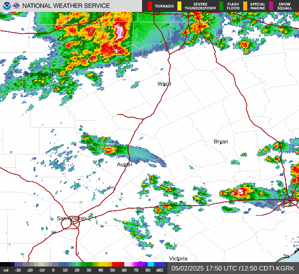
We have showers moving up Hwy 21 from Bastrop toward College Station.
-
biggerbyte
- Posts: 1437
- Joined: Thu Feb 04, 2010 12:15 am
- Location: Porter, Texas. (Montgomery County)
- Contact:
Is anyone dizzy yet? Back and forth we go. Just when Dorothy thought the wind was taking her back to Kansas. Hmmm.
I wonder if she clicked her just one more time Texas would get another snow...
I wonder if she clicked her
 just one more time Texas would get another snow...
-
DoctorMu
- Posts: 8027
- Joined: Sun Jun 28, 2015 11:58 am
- Location: College Station
- Contact:
All on board the light rail Train heading through College Station! We're getting soaked.
-
Stratton20
- Posts: 5818
- Joined: Tue Feb 09, 2021 11:35 pm
- Location: College Station, Texas
- Contact:
Well i can tell you that certainly wasn’t on my bingo card , never seen the CPC make such an aggressive trigger on hazardous cold this far out, already a moderate risk issued and normally they start with a slight risk first, that has my interest has they arent usually that fast to pull the trigger on cold
- Attachments
-
- IMG_3549.png
- (381.39 KiB) Downloaded 14552 times