
January 2025
-
sambucol

- Posts: 1248
- Joined: Wed Feb 03, 2010 5:43 pm
- Location: Mont Belvieu
- Contact:
Liking the EURO
-
snowman65

- Posts: 1415
- Joined: Thu Feb 04, 2010 6:39 am
- Location: Orange, Tx
- Contact:
Looks good but I dont understand the scale on the right. What is it telling us for Orange/Beaumont area?
-
mcheer23
- Global Moderator

- Posts: 607
- Joined: Fri Jan 11, 2013 11:15 am
- Location: Missouri City/ Sugar Land
- Contact:
Euro may be a bit nasty below I-10 light glaze of ice along with the snow.
-
Cromagnum
- Posts: 3076
- Joined: Thu Feb 03, 2011 10:42 pm
- Location: Georgetown
- Contact:
-
sswinney
- Posts: 64
- Joined: Thu Aug 24, 2017 3:29 pm
- Location: League City
- Contact:
Nice I’m under that pink purple blob right in the middle.
I’ll send yall pictures.
Been here for years since Katrina.
-
tireman4

- Global Moderator
- Posts: 7161
- Joined: Wed Feb 03, 2010 9:24 pm
- Location: Humble, Texas
- Contact:
The Noon Hour Update
AVIATION...
(18Z TAF Issuance)
Issued at 1223 PM CST Thu Jan 16 2025
VFR conditions will generally prevail through the duration of the
TAF period, with north winds in the 5 to 10 knot range throughout
the course of the afternoon. Expect winds to become light and
variable overnight before shifting to the south and increasing
into tomorrow morning. Cigs should develop above MVFR levels with
the return of onshore winds. A brief window of fog is possible
late tonight and into tomorrow morning with the return of low-
level moisture, but chances remain marginal enough as to not
include in the current TAF package for now. Increasing clouds and
persistent south winds remain in the forecast tomorrow, with rain
chances picking up tomorrow night beyond the current TAF period.
-
tireman4
- Global Moderator
- Posts: 7161
- Joined: Wed Feb 03, 2010 9:24 pm
- Location: Humble, Texas
- Contact:
Nice explanation from the AustinMan at S2K
To amplify or not to amplify is the question. Problem is, the vorticity associated with the possible secondary shortwave to be is still south of the Aleutian Islands. Until it gets onshore Saturday/Sunday, we will probably continue to see very drastic back-and-forths and spread in the guidance. Unsurprisingly, the NBM probabilistic spread (the difference between the 75th and 25th percentile, that is, the span of the middle 50%) for temperatures Tuesday and Wednesday is larger than the spread 10 days from now. A lot hinges on whether the secondary reinforcing cold can materialize.
To amplify or not to amplify is the question. Problem is, the vorticity associated with the possible secondary shortwave to be is still south of the Aleutian Islands. Until it gets onshore Saturday/Sunday, we will probably continue to see very drastic back-and-forths and spread in the guidance. Unsurprisingly, the NBM probabilistic spread (the difference between the 75th and 25th percentile, that is, the span of the middle 50%) for temperatures Tuesday and Wednesday is larger than the spread 10 days from now. A lot hinges on whether the secondary reinforcing cold can materialize.
- Attachments
-
- 12z Euro 01 16 25.jpg
- (363.8 KiB) Downloaded 2961 times
-
- 12Z GFS 01 16 25.jpg
- (344.92 KiB) Downloaded 2961 times
-
tireman4
- Global Moderator
- Posts: 7161
- Joined: Wed Feb 03, 2010 9:24 pm
- Location: Humble, Texas
- Contact:
Weather Apps Explained
Chris Michaels
@WRAL_Michaels
CBM #768 | Meteorologist for WRAL in Raleigh, NC.
Chris Michaels
@WRAL_Michaels
CBM #768 | Meteorologist for WRAL in Raleigh, NC.
- Attachments
-
- Weather Apps Explained 01 16 25.jpg (162.97 KiB) Viewed 4144 times
-
sswinney
- Posts: 64
- Joined: Thu Aug 24, 2017 3:29 pm
- Location: League City
- Contact:
Here’s an idea. Crowd sourced weather data and weather forecasting. I wonder if this type of an app has been considered. I’d start working on it but I’m no good at coding.
Been here for years since Katrina.
-
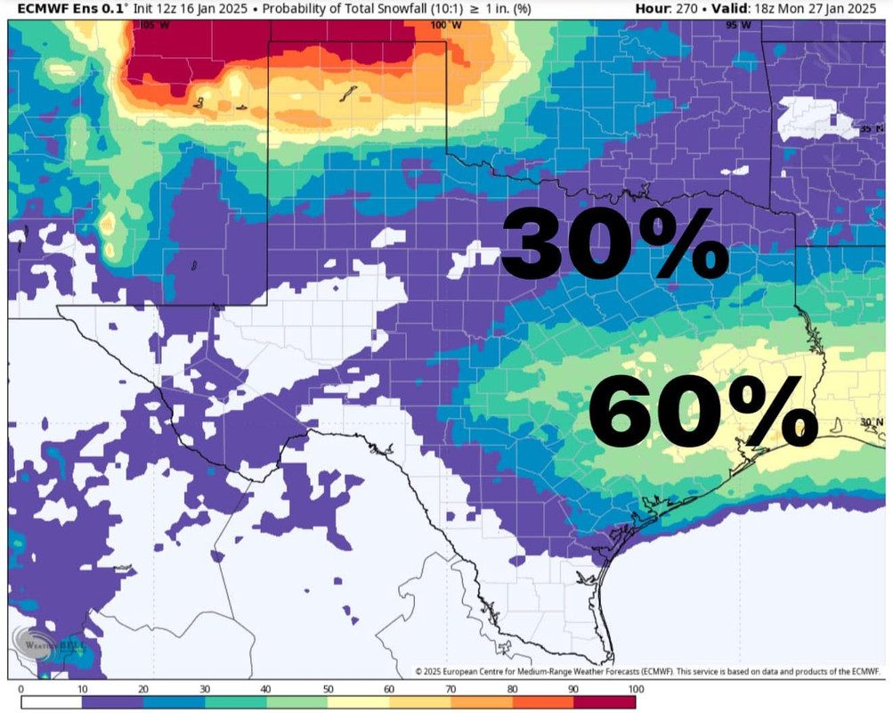
Cpv17
- Posts: 7109
- Joined: Fri Aug 31, 2018 1:58 pm
- Location: El Campo/Wharton
- Contact:
Snow probabilities of at least 1” from the Euro ensemble:
-
Stratton20
- Posts: 5870
- Joined: Tue Feb 09, 2021 11:35 pm
- Location: College Station, Texas
- Contact:
Loving that!
-
DoctorMu

- Posts: 8091
- Joined: Sun Jun 28, 2015 11:58 am
- Location: College Station
- Contact:
CMC nailed the February 2021 stormBrazoriatx979 wrote: ↑Thu Jan 16, 2025 10:32 amwell that's encouraging
-
snowman65
- Posts: 1415
- Joined: Thu Feb 04, 2010 6:39 am
- Location: Orange, Tx
- Contact:
-
tireman4
- Global Moderator
- Posts: 7161
- Joined: Wed Feb 03, 2010 9:24 pm
- Location: Humble, Texas
- Contact:
The HGX NWS folks have a new weather product. It is called Winter Weather and it is can by scrolling on the Forecasts icon. This could be interesting next week.
- Attachments
-
- Winter Weather IV.jpg
- (109.32 KiB) Downloaded 2767 times
-
- Winter Weather Outlook 01 16 25.jpg
- (159.83 KiB) Downloaded 2767 times
-
- Winter Weather Product ( Experimental) 01 16 25.jpg
- (191.51 KiB) Downloaded 2769 times
-
- Winter Weather Product (Experimental) II 01 16 25.jpg
- (200.74 KiB) Downloaded 2769 times
-
- Winter Weather Product (Experimental) III 01 16 25.jpg
- (158.6 KiB) Downloaded 2769 times
-
DoctorMu
- Posts: 8091
- Joined: Sun Jun 28, 2015 11:58 am
- Location: College Station
- Contact:
Yep. This air is dense- a 1058 mb high in Canada. It’s crashing down the spine of the Rockies. The cold is in place when the disturbance comes. The setup is (still) there. The rest is luck 5 days out.
cid:1f0e2ee7-621c-4227-9530-4d6d2be071bc@namprd11.prod.outlook.com
Physics wins.
Helwithitthescreensavr. See POW Ponder’s latest.
-
sambucol
- Posts: 1248
- Joined: Wed Feb 03, 2010 5:43 pm
- Location: Mont Belvieu
- Contact:
If we do indeed get ice or snow in SETX, how long will that last?
-
Brazoriatx979
- Posts: 565
- Joined: Tue Nov 26, 2024 10:10 am
- Location: Angleton
- Contact:
probably melt Thursday or Friday but freeze again if we get below freezing
Last edited by Brazoriatx979 on Thu Jan 16, 2025 3:01 pm, edited 1 time in total.
-
Stormlover2020
- Posts: 575
- Joined: Mon Jun 01, 2020 6:04 pm
- Contact:
Snow pack up north, snow down here with cold in place, Tuesday-Friday snow will stick around on ground in most places that have trees and shade
-
Cpv17
- Posts: 7109
- Joined: Fri Aug 31, 2018 1:58 pm
- Location: El Campo/Wharton
- Contact:
That sounds about right.Stormlover2020 wrote: ↑Thu Jan 16, 2025 3:00 pm Snow pack up north, snow down here with cold in place, Tuesday-Friday snow will stick around on ground in most places that have trees and shade