
NWS has really upped rain chances over the Labor Day weekend.
However, the Ensembles are leaning to more of the same with most of the rain offshore. There will be a lot of random local sea breeze showers. We may get peppered enough so everyone gets an inch or two or five over the next week.
August 2024
-
DoctorMu

- Posts: 8089
- Joined: Sun Jun 28, 2015 11:58 am
- Location: College Station
- Contact:
- Attachments
-
- qpf_acc-mean-imp.us_sc.png
- (405.84 KiB) Downloaded 24629 times
-
- qpf_acc-mean-imp.us_sc-1.png
- (407.56 KiB) Downloaded 24629 times
-
- qpf_acc-imp.us_sc.png
- (597.29 KiB) Downloaded 24629 times
-
djmike

- Posts: 1883
- Joined: Fri Jan 07, 2011 12:19 pm
- Location: BEAUMONT, TX
- Contact:
And right on Que. showers dissipating as they move onshore. Mets said we would have a wet morning commute and nadda!
Mike
Beaumont, TX
(IH-10 & College Street)
Beaumont, TX
(IH-10 & College Street)
-
jasons2k

- Posts: 6201
- Joined: Thu Feb 04, 2010 12:54 pm
- Location: Imperial Oaks
- Contact:

-
Pas_Bon
- Posts: 968
- Joined: Tue Sep 11, 2018 7:58 am
- Location: League City, TX
- Contact:
I'm really curious to know the meteorological explanation for it. I've missed out on just about everything all week. I didn't water on purpose....hope plants make it. Ugh.
I'm even going to miss out on this one current band (Thurs 10:15am) that held up until League City (which is already dissipating and broke at the point just south of me....I'm in west League City. We get zilch when areas east of 45 do. It's maddening.
-
tireman4

- Global Moderator

- Posts: 7161
- Joined: Wed Feb 03, 2010 9:24 pm
- Location: Humble, Texas
- Contact:
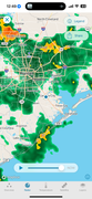
Incoming....
- Attachments
-
- Radar 10 40 am 08 29 24.jpg (124.16 KiB) Viewed 35601 times
-
Rip76

- Posts: 2151
- Joined: Mon Feb 15, 2010 12:38 am
- Location: The Woodlands
- Contact:
Lindner's Latest
NW Gulf:
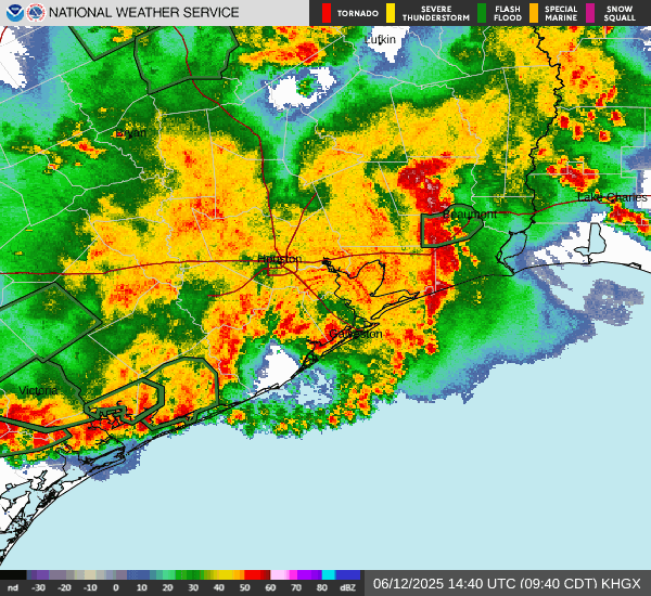
Unsettled weather remains in place over the NW Gulf of Mexico with numerous showers and thunderstorms. This weather is a result of a plume of tropical moisture in combination surface trough and mid/upper level trough over coastal Texas. Over the next 24-48 hours the moisture axis will generally move northward into the SW LA and SE TX coast and then inland along the Sabine River Valley into Saturday. Moisture levels are extremely high over the area with PWS of 2.0-2.4 inches and a nearly saturated profile which will support high short term rainfall rates. The main question over the next 24-36 hours is if there any slight organization of a surface low/trough over the coastal waters and does that consolidate the heavier rainfall into a certain area. High resolution guidance seems to be pointing toward the area from roughly Brazoria County to southeast Harris County and then eastward toward the LA border for the heaviest rainfall where WPC has placed the area under a slight risk of excessive rainfall. It is possible that the heaviest rains remain over the Gulf waters as can be common in such tropical air masses.
Rainfall amounts of 1-3 inches over much of the area can be expected with totals of 4-6 inches along the coastal counites (Brazoria, Galveston, Chambers). Isolated totals of up to 8 inches may be possible especially along the coast. Hourly rainfall rates of 1-3 inches per hour will be possible in the stronger storms which will lead to street flooding. Again the heaviest rainfall looks to focus near the coast.
Atlantic Wave:
A tropical wave in the Atlantic midway between Africa and the eastern Caribbean Sea is moving westward at 10-15mph with little organization of thunderstorms activity this morning. While development of this feature is not expected over the next 48-72 hours conditions will become generally increasingly favorable for development as the wave axis approaches the eastern Caribbean Sea by early next week. The degree of development and potential longer term track has uncertainty with several variables at play. At this point following the various ensemble guidance is the better course of action than any individual model run that can have significant run to run variations. The NHC currently gives this feature a 40% chance of development over the next 7 days.
NW Gulf:
Unsettled weather remains in place over the NW Gulf of Mexico with numerous showers and thunderstorms. This weather is a result of a plume of tropical moisture in combination surface trough and mid/upper level trough over coastal Texas. Over the next 24-48 hours the moisture axis will generally move northward into the SW LA and SE TX coast and then inland along the Sabine River Valley into Saturday. Moisture levels are extremely high over the area with PWS of 2.0-2.4 inches and a nearly saturated profile which will support high short term rainfall rates. The main question over the next 24-36 hours is if there any slight organization of a surface low/trough over the coastal waters and does that consolidate the heavier rainfall into a certain area. High resolution guidance seems to be pointing toward the area from roughly Brazoria County to southeast Harris County and then eastward toward the LA border for the heaviest rainfall where WPC has placed the area under a slight risk of excessive rainfall. It is possible that the heaviest rains remain over the Gulf waters as can be common in such tropical air masses.
Rainfall amounts of 1-3 inches over much of the area can be expected with totals of 4-6 inches along the coastal counites (Brazoria, Galveston, Chambers). Isolated totals of up to 8 inches may be possible especially along the coast. Hourly rainfall rates of 1-3 inches per hour will be possible in the stronger storms which will lead to street flooding. Again the heaviest rainfall looks to focus near the coast.
Atlantic Wave:
A tropical wave in the Atlantic midway between Africa and the eastern Caribbean Sea is moving westward at 10-15mph with little organization of thunderstorms activity this morning. While development of this feature is not expected over the next 48-72 hours conditions will become generally increasingly favorable for development as the wave axis approaches the eastern Caribbean Sea by early next week. The degree of development and potential longer term track has uncertainty with several variables at play. At this point following the various ensemble guidance is the better course of action than any individual model run that can have significant run to run variations. The NHC currently gives this feature a 40% chance of development over the next 7 days.
-
Cpv17
- Posts: 7109
- Joined: Fri Aug 31, 2018 1:58 pm
- Location: El Campo/Wharton
- Contact:
The 12z GFS looks freaking awesome for the state of Texas. Wish that would verify.
-
jasons2k
- Posts: 6201
- Joined: Thu Feb 04, 2010 12:54 pm
- Location: Imperial Oaks
- Contact:
Finally getting a nice soaking here.
-
Cpv17
- Posts: 7109
- Joined: Fri Aug 31, 2018 1:58 pm
- Location: El Campo/Wharton
- Contact:
-
Pas_Bon
- Posts: 968
- Joined: Tue Sep 11, 2018 7:58 am
- Location: League City, TX
- Contact:
We are in a hole again. Barely got any drops.
Dissipated, then re-formed just north of league city. Ughhhh
Dissipated, then re-formed just north of league city. Ughhhh
-
DoctorMu
- Posts: 8089
- Joined: Sun Jun 28, 2015 11:58 am
- Location: College Station
- Contact:
Interesting. We'll probably get the donut hole, but...there's a chance..
-
Stratton20
- Posts: 5870
- Joined: Tue Feb 09, 2021 11:35 pm
- Location: College Station, Texas
- Contact:
Depends, ive seen 2.5-3 inches the last 2 days, this pattern lasts into next weekend, everyone will see rain, just maybe not 5-6-7-8 inches
-
Cpv17
- Posts: 7109
- Joined: Fri Aug 31, 2018 1:58 pm
- Location: El Campo/Wharton
- Contact:
Some places could get 5-10” and some could only get 1-2”. That’s just how it works.Stratton20 wrote: ↑Thu Aug 29, 2024 3:13 pm Depends, ive seen 2.5-3 inches the last 2 days, this pattern lasts into next weekend, everyone will see rain, just maybe not 5-6-7-8 inches
-
DoctorMu
- Posts: 8089
- Joined: Sun Jun 28, 2015 11:58 am
- Location: College Station
- Contact:
0.2 inches. At least the lawn is green.
It feels like Louisiana out there, Pas Bon. 87°F; no wind; 72°F dewpoint.
It feels like Louisiana out there, Pas Bon. 87°F; no wind; 72°F dewpoint.
-
Rip76
- Posts: 2151
- Joined: Mon Feb 15, 2010 12:38 am
- Location: The Woodlands
- Contact:
-
don

- Posts: 3148
- Joined: Wed Feb 03, 2010 3:33 pm
- Location: Wichita Falls
- Contact:
Yep. Feast or FamineCpv17 wrote: ↑Some places could get 5-10” and some could only get 1-2”. That’s just how it works.Stratton20 wrote: ↑ Depends, ive seen 2.5-3 inches the last 2 days, this pattern lasts into next weekend, everyone will see rain, just maybe not 5-6-7-8 inches

-
Pas_Bon
- Posts: 968
- Joined: Tue Sep 11, 2018 7:58 am
- Location: League City, TX
- Contact:
-
jasons2k
- Posts: 6201
- Joined: Thu Feb 04, 2010 12:54 pm
- Location: Imperial Oaks
- Contact:
Picked up .61” today.
Plants are happy again.
Plants are happy again.
-
DoctorMu
- Posts: 8089
- Joined: Sun Jun 28, 2015 11:58 am
- Location: College Station
- Contact:
This afternoon I was on a quest to find non-frozen Gulf shrimp form some shrimp creole. After Beryl, HEB stocked more and more nasty previously frozen shrimp...and the nice brown jumbo Gulf shrimp have been completely disappeared. Evidently, store stock is coming from Temple now instead of Houston or San Antonio. Kroger's shrimp looked even more decrepit. We don't have a Fiesta Mart in Aggieland. The two fish markets in B/CS evidently closed during COVID.
So... I can't find fresh seafood anywhere in this freakin' cowtown! You'd think we were a 1000 miles from the Gulf or ocean. And our barbecue should be a lot better. The guy with the best grill in town (1975) closed shop after last summer - it was so hot.
I'm strongly considering knocking off work early tomorrow and taking a road trip to Huntsville and the closest fish market. Otherwise, I'm barbecuing some chicken with a gochujang marinade and sauce tomorrow night.
My point is that I dropped by Tad's restaurant in town which has sort of Louisiana food - the crawfish in season aren't bad. I asked where their seafood shipments came from. Evidently they ship it from Lake Charles or Youngsville, LA - close to your old stomping ground.
I went to a wedding in New Iberia once and dated a girl from Abbeville back in the day. My wife's dad is from the Baton Rouge area - she's an LSU grad. He worked for Exxon/Esso/Standard Oil in Texas and NOLA for 35 years.