
2024 Hurricane Season Discussion
-
Stratton20
- Posts: 5870
- Joined: Tue Feb 09, 2021 11:35 pm
- Location: College Station, Texas
- Contact:
The target date for the switch has always been around the 15th so we still have time to go, also keep in mind models offen have huge trouble seeing the favorable tropical forcing entering the atlantic, so that is something to keep in mind, its going to get active, just waiting on the big push from the MJO
-
Stormlover2020
- Posts: 575
- Joined: Mon Jun 01, 2020 6:04 pm
- Contact:
Yeah well did you see what phil came out with today??
-
Stratton20
- Posts: 5870
- Joined: Tue Feb 09, 2021 11:35 pm
- Location: College Station, Texas
- Contact:
Despite the lack of model guidance, the CPC has a hatched area for possible development in the western gulf between august 14-20th, I wonder what they are seeing? I dont see anything in guidance popping up, would love to know what a pro met on here thinks about this
- Attachments
-
- IMG_3286.png
- (560.05 KiB) Downloaded 5787 times
-
Cpv17
- Posts: 7109
- Joined: Fri Aug 31, 2018 1:58 pm
- Location: El Campo/Wharton
- Contact:
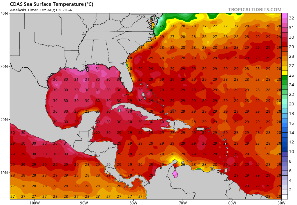
SST’s in the western Gulf are exploding now. Lots of 31°C temps are popping up. Getting primed for mid August through late September.
-
Cpv17
- Posts: 7109
- Joined: Fri Aug 31, 2018 1:58 pm
- Location: El Campo/Wharton
- Contact:
This season so far is following according to plan. Nothing has changed. To say it’s only August 6th and we’ve already had 2 landfalling hurricanes is pretty wild.Pas_Bon wrote: ↑Tue Aug 06, 2024 12:52 pmOk. The adage being true. I get it. But we were supposed to have record numbers of storms forming. I’m done, too, by the way. I’m not ballyhooing a relatively inactive lull we’ve had - Debby and Beryl aside, but where are the storms?Cromagnum wrote: ↑Tue Aug 06, 2024 12:38 pmPas_Bon wrote: ↑Tue Aug 06, 2024 8:58 am
I’ll agree with him on this.
I will say that this hurricane season seems like it is a major bust at this point compared to the hype it was given (there was great reason for the hype)
It may be considered busy for a “normal” season analog, but it sure seems that storms are having a hard time getting going
All it takes is one for someone to consider it a bad season. For me, I'm already done and don't want anymore.
-
Stratton20
- Posts: 5870
- Joined: Tue Feb 09, 2021 11:35 pm
- Location: College Station, Texas
- Contact:
MJO passes into the atlantic basin in about 7-8 days, its about to get really busy, once models adjust to that ossage, they will light up with activity
-
Cpv17
- Posts: 7109
- Joined: Fri Aug 31, 2018 1:58 pm
- Location: El Campo/Wharton
- Contact:
Yep, things will get going mid month.Stratton20 wrote: ↑Tue Aug 06, 2024 6:12 pm MJO passes into the atlantic basin in about 7-8 days, its about to get really busy, once models adjust to that ossage, they will light up with activity
-
Cpv17
- Posts: 7109
- Joined: Fri Aug 31, 2018 1:58 pm
- Location: El Campo/Wharton
- Contact:
We really don’t wanna see a storm get into the Gulf right now…yikes!
-
Stratton20
- Posts: 5870
- Joined: Tue Feb 09, 2021 11:35 pm
- Location: College Station, Texas
- Contact:
Cpv17 not at all! And thats why im worried that Beryl was just an appetizer and that the main course is still to come, when that MJO moves in, watch out!
-
Scott747
- Posts: 1659
- Joined: Tue Feb 23, 2010 9:56 am
- Location: Freeport/Surfside Beach
- Contact:
Psst....
We just had one. Went by the name of Hurricane Debby. Still had issues making it to a hurricane.
-
Cpv17
- Posts: 7109
- Joined: Fri Aug 31, 2018 1:58 pm
- Location: El Campo/Wharton
- Contact:
Haha yeah but things will probably be more favorable later this month and those SST’s sure won’t help. Plus if a storm comes to Texas it has a lot more time over water compared to going to FL.
-
Stratton20
- Posts: 5870
- Joined: Tue Feb 09, 2021 11:35 pm
- Location: College Station, Texas
- Contact:
Hurricane Debby formed during a sinking phase of the MJO which is a little concerning giving environmental conditions werent overly conducive for it, not a whole lot of upward rising motion in the basin right now, once we get that upward rising motion to set in to our part of the basin in about week, it could be a doozy
-
biggerbyte
- Posts: 1441
- Joined: Thu Feb 04, 2010 12:15 am
- Location: Porter, Texas. (Montgomery County)
- Contact:
Outside of something home grown, it looks like a bunch of fish storms are in order. The current pattern will give way to systems coming out of Africa being pulled off to the north. The change will come, but for now....
-
Stratton20
- Posts: 5870
- Joined: Tue Feb 09, 2021 11:35 pm
- Location: College Station, Texas
- Contact:
I wouldnt be so sure about that, if the wave comes off at a low latitude and waits to develop later, it could completely miss the weakness over the atlantic, and that pattern doesnt last long, that trough gets kicked out and replaced by ridging again
-
biggerbyte
- Posts: 1441
- Joined: Thu Feb 04, 2010 12:15 am
- Location: Porter, Texas. (Montgomery County)
- Contact:
Yes. The trough is expected to not be a factor, and the ridge would build back west. Depending on how much it expands we are still speaking about a more poleward turn maybe into Florida or the east coast. These waves coming in on more southern track usually get eaten up by areas well south of Texas. It's all about the obvious for the day. As I mentioned, today we see conditions favorable for a certain outcome. That is about to change around the middle of this month.
-
tireman4

- Global Moderator

- Posts: 7161
- Joined: Wed Feb 03, 2010 9:24 pm
- Location: Humble, Texas
- Contact:
The Eyewall
Matt Lanza
Debby readying to come back ashore -- slowly
You might be confused when looking at Debby this afternoon. It barely resembles a tropical storm. But as has been the case with Debby since it was a tropical wave, it's the size that really does it. Hurricane hunters found 60 mph winds about 100 miles away from the center, so Debby is currently a large, lumbering tropical storm.
Debby is slowly lifting back north toward the coast of South Carolina.
Tropical storm force winds extend out about 185 miles from the center. This also means Debby will have a bit widespread storm surge potential as it makes final approach tonight.
A 1 to 3 foot surge is expected between Folly Beach, SC and the Outer Banks as Debby maneuvers north today and tonight.
Certainly not the worst surge we've ever seen here, but spatially it will cover a wide area. From here, Debby will continue generally north and eventually northeast, accelerating and transitioning into an extratropical storm as it moves out of the Southeast.
Debby's track takes it up the Appalachians and into Quebec and Labrador through the weekend.
Debby will track through North Carolina tomorrow, into Virginia early Friday, and across Pennsylvania and New York Friday afternoon and evening, into Canada this weekend.
Today's concerns
Heavy rain is ongoing again in South Carolina this afternoon. In addition, a couple tornado warnings are in effect in North Carolina as I write this.
A high risk, level 4/4 of excessive rainfall is in place for much of southeastern North Carolina and northeastern South Carolina today. Some of the rain coming ashore now near North Myrtle Beach is quite heavy, and we'll probably see flooding begin not too long from now in these areas.
A high risk of flooding exists today for portions of the Carolinas, including Lumberton, Wilmington, Myrtle Beach, and Florence, which also includes portions of I-95.
Debby will only slowly come ashore today and tonight, so this rain isn't going to move a whole ton. Hence why we see the flooding risks beginning to increase now.
Thursday's concerns
Debby will make an effort to get to the North Carolina border north of Florence tomorrow. This means that rain is only going to gradually expand northward. But that said, we will likely see a high risk again emerge for considerable flash flooding up into central and eastern North Carolina, including Fayetteville, RDU, and parts of the Piedmont.
The high risk (level 4/4) of flash flooding lifts north later tomorrow, expanding to include Fayetteville, Raleigh-Durham, and portions of the Piedmont.
We could easily see 3 to 6 inches of rain anywhere in this region. Higher amounts are possible as well. Rapid onset flash flooding is likely to take place, so limiting travel in this area, and possibly avoiding I-95 south of Rocky Mount isn't a bad idea tomorrow. Conditions should improve Friday in much of this area.
Friday's focus comes north
As Debby begins to accelerate north, getting absorbed into an upper atmospheric trough of low pressure Friday and Saturday, its heavy rain will also come northward. We expect to see a period of heavy rain as Debby's core comes north along the eastern front of the Appalachians across Virginia, Central Pennsylvania, and Central New York. Some of these areas have seen very heavy rainfall recently, and it will take very little for flooding to unfold once more.
Total rainfall through Saturday and Sunday will be about 2 to 5 inches, with locally higher amounts possible between the Blue Ridge and Central New York into the St. Lawrence Valley of Quebec.
As of now, the moderate risk (level 3 of 4) for excessive rain does not include Philadelphia, New York City, or New Jersey, although some locally heavy rain is possible there too. It does include Harrisburg, Scranton, Syracuse, Utica, and Burlington, among other places. Portions of Vermont are extremely vulnerable to flooding right now, and any shift in Debby's track could lead to a larger impact there.
From there, Debby heads into Canada, where heavy rain is likely across Quebec and Labrador. The heaviest rain should follow the St. Lawrence across Quebec. with perhaps even some locally heavy rain in Newfoundland's Great Northern Peninsula. And then Debby will be gone. Goodbye.
Elsewhere in the tropics
Let's get you caught up on some other issues in the tropics. First, the area in the Caribbean that we've been watching has seen a significant decline in development odds since yesterday. They've just been taken down to 0 percent, and as I noted yesterday, high pressure over Texas and the South should keep this wave firmly suppressed south of the Gulf. That's that.
The Euro ensemble has multiple members showing some sort of signal for a system in the southwest Atlantic or northern Caribbean next week.
Looking farther east and farther out in time, we're seeing a signal on European ensemble modeling for potentially two more waves to watch. The first one would arrive in the Lesser Antilles or nearby in about 5 or 6 days. No development is expected out of this one before then. Look for this to perhaps get added to the NHC big board tomorrow if model trends continue. Once in the eastern Caribbean or near the islands, it will sort of be at a crossroads. A weaker system or disorganized wave would probably get forced south and west back into the Caribbean and off to the west by strong high pressure over the South. A slightly better organized system would almost certainly feel the "pull" of the deep trough over New England.
Next week's players as shown by the 06z European ensemble mean at 500 mb, 20,000 feet up. We'll have a better idea on this in the coming days.
It's too early to speculate on what is more likely. The Euro ensemble certainly favors the "capture" scenario, but I've seen situations like this where the high is a little too strong and forces a southwest motion earlier, avoiding the capture. So I'm basically unsure about this wave. For now, it's not a concern for anyone, but as is the case in August, check back in a day or two to see what's changed.
Additional waves may develop off Africa heading into late month, but we don't have any specific details as of yet.
Sponsors
-
Stratton20
- Posts: 5870
- Joined: Tue Feb 09, 2021 11:35 pm
- Location: College Station, Texas
- Contact:
12z Euro ensembles have shifted west, less recurving, more closer to the SE US and some even getting into the gulf
-
Pas_Bon
- Posts: 968
- Joined: Tue Sep 11, 2018 7:58 am
- Location: League City, TX
- Contact:
Question…..Stratton20 wrote: ↑Wed Aug 07, 2024 2:06 pm 12z Euro ensembles have shifted west, less recurving, more closer to the SE US and some even getting into the gulf
Where does one find the scatter-shot ensemble plots?
-
Cpv17
- Posts: 7109
- Joined: Fri Aug 31, 2018 1:58 pm
- Location: El Campo/Wharton
- Contact:
Are you talking about on Tropical Tidbits?Pas_Bon wrote: ↑Wed Aug 07, 2024 4:20 pmQuestion…..Stratton20 wrote: ↑Wed Aug 07, 2024 2:06 pm 12z Euro ensembles have shifted west, less recurving, more closer to the SE US and some even getting into the gulf
Where does one find the scatter-shot ensemble plots?
-
Pas_Bon
- Posts: 968
- Joined: Tue Sep 11, 2018 7:58 am
- Location: League City, TX
- Contact:
Yes. There are ensemble renderings showing animated points to signify ensemble members (rather than straight lines). I’ve not been able to locate how to get those model/ensemble renderingsCpv17 wrote: ↑Wed Aug 07, 2024 4:52 pmAre you talking about on Tropical Tidbits?Pas_Bon wrote: ↑Wed Aug 07, 2024 4:20 pmQuestion…..Stratton20 wrote: ↑Wed Aug 07, 2024 2:06 pm 12z Euro ensembles have shifted west, less recurving, more closer to the SE US and some even getting into the gulf
Where does one find the scatter-shot ensemble plots?