I feel like they’re always terrible around where you live.Cromagnum wrote: ↑Mon Jul 15, 2024 3:39 pmThey already are. I was driving along 288 on Saturday evening near a field and my truck was plastered by a gigantic swarm of them. Had to spray it off when I got home and it smelled absolutely horrible.
July 2024
-
Cpv17
- Posts: 7109
- Joined: Fri Aug 31, 2018 1:58 pm
- Location: El Campo/Wharton
- Contact:
-
Cromagnum
- Posts: 3076
- Joined: Thu Feb 03, 2011 10:42 pm
- Location: Georgetown
- Contact:
Lots of rice fields.Cpv17 wrote: ↑Mon Jul 15, 2024 8:48 pmI feel like they’re always terrible around where you live.
-
tireman4

- Global Moderator

- Posts: 7161
- Joined: Wed Feb 03, 2010 9:24 pm
- Location: Humble, Texas
- Contact:
653
FXUS64 KHGX 161104
AFDHGX
Area Forecast Discussion
National Weather Service Houston/Galveston TX
604 AM CDT Tue Jul 16 2024
...New AVIATION...
.SHORT TERM...
(Today through Wednesday Night)
Issued at 414 AM CDT Tue Jul 16 2024
With the slightly drier air mass remaining in place over SE TX, rain
chances should stay on the low side today (~20%)...but look for POPs
to increase once again tomorrow (20-30%) as moisture levels begin to
climb (from the Gulf). Aloft, the synoptic pattern where SE TX ling-
ers in the weakness region between the ridging will persist. And so,
as PWs increase back into the 1.9-2.1" range on Weds, scattered act-
ivity should be possible once again through the afternoon.
In the meantime, mostly to partly sunny skies will help with daytime
highs in the mid and upper 90s around the Brazos Valley...mid 90s in
the Piney Woods down to the I-10 corridor, and then the lower 90s at
and near the coast for today (and likely tomorrow). This will trans-
late to peak heat index values in the 102-108F range during the late
morning into the early evening hours. Lows will be in the mid to up-
per 70s....around 80 at the beaches.
41
&&
.LONG TERM...
(Thursday through Monday)
Issued at 414 AM CDT Tue Jul 16 2024
The upper-level pattern doesn`t change much through the long term: a
large ridge of high pressure centered over the Great Basin/Desert
Southwest and a large amplitude trough over the Great Lakes/Midwest.
This set up will bring persistent upper-level northwesterly flow
through the long term with shortwaves riding along the edge of the
trough bringing SE Texas rising shower and thunderstorm chances.
A rather potent shortwave moves through during the day on
Thursday, which will be able to tap into PWATs of 1.75-2.1"
bringing scattered to widespread showers and thunderstorms causing
locally heavy rainfall. This shortwave will bring a diffuse, weak
boundary that is expected to stall along/near the Gulf Coast
through the weekend. Another shortwave is expected to pass through
on Friday reinvigorating the rainfall across the boundary. WPC
has place parts of SE Texas in a Marginal Risk (level 1 of 4) for
Excessive Rainfall Thursday and Friday.
The start of the weekend looks to be a bit of a lull, but cannot out-
rule some afternoon showers and thunderstorms driven by daytime
heating. Guidance is indicating that the upper level ridge to the
west will shift a bit further to the west Sunday into next week
allowing the disturbances also to slide a bit west. PWATs also rise
to 2-2.3" by the start of next week. The increase in moisture plus
stronger disturbances is looking to set up for a rather wet week
with scattered to widespread showers and thunderstorms beginning
Sunday afternoon with high chances continuing into the workweek.
Thursday is looking to be the hottest day of the long term with high
temperatures rising into the low to mid 90s for much of the region.
Afternoon highs will remain in the upper 80s to low 90s through
Monday with the daily rainfall chances helping to keep temperatures
down. The high moisture content of the air and southerly flow will
keep overnight lows above normal with minimum temperatures staying
in the mid to upper 70s for much of the region (and low 80s along
the immediate coast)
Fowler
&&
.AVIATION...
(12Z TAF Issuance)
Issued at 545 AM CDT Tue Jul 16 2024
Quiet weather to prevail this TAF package and VFR conditions are ex-
pected throughout. Isolated showers are possible along and near the
coast this morning and again tomorrow morning, but will not add any
mention at this time. Light S winds this morning (3-6kts) should be
increasing this afternoon to around 10kts, then decreasing again by
this evening. 41
&&
.MARINE...
Issued at 414 AM CDT Tue Jul 16 2024
Light onshore flow will persist through midweek with seas around 1
to 3 ft. There will be isolated showers and thunderstorms during the
late night to early morning hours in the Gulf Waters, and in the mid
morning through the afternoon near the coast and in the Bays. Storm
chances do increase by Thursday as a weak boundary approaches and
stalls near the coast helping to initiate precipitation. This
stalled boundary also may cause the winds to become variable at
times Thursday and Friday. Onshore flow becomes predominate again
over the weekend into next week with continued chances of showers
and thunderstorms.
Fowler
&&
.PRELIMINARY POINT TEMPS/POPS...
College Station (CLL) 97 76 97 76 / 0 0 10 10
Houston (IAH) 95 78 94 77 / 10 10 40 10
Galveston (GLS) 90 82 89 80 / 10 10 40 20
&&
.HGX WATCHES/WARNINGS/ADVISORIES...
TX...None.
GM...None.
&&
$$
SHORT TERM...41
LONG TERM....Fowler
AVIATION...41
MARINE...Fowler
-
tireman4
- Global Moderator
- Posts: 7161
- Joined: Wed Feb 03, 2010 9:24 pm
- Location: Humble, Texas
- Contact:
Big Changes Coming?
- Attachments
-
- Pete Cavlin 07 16 24.png (214.06 KiB) Viewed 6201 times
-
Pas_Bon
- Posts: 968
- Joined: Tue Sep 11, 2018 7:58 am
- Location: League City, TX
- Contact:
Honestly, there were 2 2023-like weeks end of June into the first days of July, but otherwise, it's been quite pleasant (compared to last Summer).
I know I said this early on in June and took it back briefly end of June (lol), but we have definitely earned it.
I hope this pattern persists into August/September.
Which begs the question.....would you rather a persistent death ridge with very little rain all summer like last year? Or a setup like this, but with higher risk of landfalling tropical systems?
-
DoctorMu

- Posts: 8091
- Joined: Sun Jun 28, 2015 11:58 am
- Location: College Station
- Contact:
Yep - what a difference a year makes. Another Midwestern trough dips down.
We have not hit the century mark for temps in CLL after about 80 days of 100°F or over and tying the all time record of 112.5°F again and again. Last summer was the hottest year on record here.
Next week is progged to have highs in the 80s for 4-5 days. Last week, naturally Beryl tempt temps in the 80s and Friday with cloud cover also saw the high fail to reach 90°F.
Give me more of this until Fall!
-
Rip76

- Posts: 2151
- Joined: Mon Feb 15, 2010 12:38 am
- Location: The Woodlands
- Contact:
Give me this pattern every summer.Pas_Bon wrote: ↑Tue Jul 16, 2024 2:43 pmHonestly, there were 2 2023-like weeks end of June into the first days of July, but otherwise, it's been quite pleasant (compared to last Summer).
I know I said this early on in June and took it back briefly end of June (lol), but we have definitely earned it.
I hope this pattern persists into August/September.
Which begs the question.....would you rather a persistent death ridge with very little rain all summer like last year? Or a setup like this, but with higher risk of landfalling tropical systems?
-
DoctorMu
- Posts: 8091
- Joined: Sun Jun 28, 2015 11:58 am
- Location: College Station
- Contact:
-
Stratton20
- Posts: 5870
- Joined: Tue Feb 09, 2021 11:35 pm
- Location: College Station, Texas
- Contact:
, I still think models are largely underestimating rainfall potential across se texas with the front becoming stationary , will need to watch flooding potential heading forwards, this is the kind of pattern that could bring that for sure
-
Ptarmigan

- Statistical Specialist

- Posts: 4536
- Joined: Wed Feb 03, 2010 7:20 pm
- Contact:
I would not be surprised. Stalled cold front regardless of season can lead to heavy rain. It could also go over the Gulf of Mexico. Sometimes an area of thunderstorm forms along the front over the Gulf of Mexico and become tropical. Think Hurricane Alicia.Stratton20 wrote: ↑Tue Jul 16, 2024 6:05 pm , I still think models are largely underestimating rainfall potential across se texas with the front becoming stationary , will need to watch flooding potential heading forwards, this is the kind of pattern that could bring that for sure
-
Pas_Bon
- Posts: 968
- Joined: Tue Sep 11, 2018 7:58 am
- Location: League City, TX
- Contact:
Exactly my concern. There will be a ton of available moisture in the Western Gulf for the next couple weeks. Models typically have a hard time picking up on cyclogenesis ahead of time with these setups, so it would behoove those who aren’t aware to keep a close eye, because we all know these homebrew systems can make landfall with relatively little notice and can strengthen rapidly.Ptarmigan wrote: ↑Tue Jul 16, 2024 9:34 pmI would not be surprised. Stalled cold front regardless of season can lead to heavy rain. It could also go over the Gulf of Mexico. Sometimes an area of thunderstorm forms along the front over the Gulf of Mexico and become tropical. Think Hurricane Alicia.Stratton20 wrote: ↑Tue Jul 16, 2024 6:05 pm , I still think models are largely underestimating rainfall potential across se texas with the front becoming stationary , will need to watch flooding potential heading forwards, this is the kind of pattern that could bring that for sure
-
Stratton20
- Posts: 5870
- Joined: Tue Feb 09, 2021 11:35 pm
- Location: College Station, Texas
- Contact:
CMC hinting at a big rain event in central texas, gonna depend on where the front stalls, but this is a classic setup for someone to get more rain than they bargained for
-
davidiowx
- Posts: 1197
- Joined: Thu Jan 23, 2014 2:39 pm
- Location: Richmond, TX
- Contact:
I am always ready from May to OctoberPas_Bon wrote: ↑Tue Jul 16, 2024 10:02 pmExactly my concern. There will be a ton of available moisture in the Western Gulf for the next couple weeks. Models typically have a hard time picking up on cyclogenesis ahead of time with these setups, so it would behoove those who aren’t aware to keep a close eye, because we all know these homebrew systems can make landfall with relatively little notice and can strengthen rapidly.Ptarmigan wrote: ↑Tue Jul 16, 2024 9:34 pmI would not be surprised. Stalled cold front regardless of season can lead to heavy rain. It could also go over the Gulf of Mexico. Sometimes an area of thunderstorm forms along the front over the Gulf of Mexico and become tropical. Think Hurricane Alicia.Stratton20 wrote: ↑Tue Jul 16, 2024 6:05 pm , I still think models are largely underestimating rainfall potential across se texas with the front becoming stationary , will need to watch flooding potential heading forwards, this is the kind of pattern that could bring that for sure
-
DoctorMu
- Posts: 8091
- Joined: Sun Jun 28, 2015 11:58 am
- Location: College Station
- Contact:
Yep. Stalled front in the GoM could be problems. Homebrew systems don't worry about African dust and shear. They can bomb out quickly.Pas_Bon wrote: ↑Tue Jul 16, 2024 10:02 pmExactly my concern. There will be a ton of available moisture in the Western Gulf for the next couple weeks. Models typically have a hard time picking up on cyclogenesis ahead of time with these setups, so it would behoove those who aren’t aware to keep a close eye, because we all know these homebrew systems can make landfall with relatively little notice and can strengthen rapidly.Ptarmigan wrote: ↑Tue Jul 16, 2024 9:34 pmI would not be surprised. Stalled cold front regardless of season can lead to heavy rain. It could also go over the Gulf of Mexico. Sometimes an area of thunderstorm forms along the front over the Gulf of Mexico and become tropical. Think Hurricane Alicia.Stratton20 wrote: ↑Tue Jul 16, 2024 6:05 pm , I still think models are largely underestimating rainfall potential across se texas with the front becoming stationary , will need to watch flooding potential heading forwards, this is the kind of pattern that could bring that for sure
-
Cpv17
- Posts: 7109
- Joined: Fri Aug 31, 2018 1:58 pm
- Location: El Campo/Wharton
- Contact:
The 12z GFS and CMC are both very wet.
-
Pas_Bon
- Posts: 968
- Joined: Tue Sep 11, 2018 7:58 am
- Location: League City, TX
- Contact:
Well, my rain chances just fell off a cliff here in League City from today through Saturday
-
Cpv17
- Posts: 7109
- Joined: Fri Aug 31, 2018 1:58 pm
- Location: El Campo/Wharton
- Contact:
-
Stratton20
- Posts: 5870
- Joined: Tue Feb 09, 2021 11:35 pm
- Location: College Station, Texas
- Contact:
Euro is widespread 3-6 inches from se texas- central and western texas, really keeps that front stalled out for the next 10 days at least
-
Cpv17
- Posts: 7109
- Joined: Fri Aug 31, 2018 1:58 pm
- Location: El Campo/Wharton
- Contact:
Don, where you at? Lol
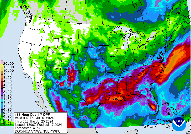
The WPC is starting to slowly buy in.
The WPC is starting to slowly buy in.
-
Cpv17
- Posts: 7109
- Joined: Fri Aug 31, 2018 1:58 pm
- Location: El Campo/Wharton
- Contact: