
A TROPICAL WAVE OVER THE EASTERN CARIBBEAN SEA IS PRODUCING A LARGE
AREA OF DISORGANIZED SHOWERS AND THUNDERSTORMS. ENVIRONMENTAL
CONDITIONS ARE EXPECTED TO BECOME MORE FAVORABLE FOR A TROPICAL
DEPRESSION TO FORM DURING THE NEXT COUPLE OF DAYS AS THE SYSTEM
MOVES WESTWARD NEAR 15 MPH. THERE IS A MEDIUM CHANCE...50
PERCENT...OF THIS SYSTEM BECOMING A TROPICAL CYCLONE DURING THE
NEXT 48 HOURS. LOCALLY HEAVY RAINFALL AND GUSTY WINDS ARE LIKELY
OVER THE WINDWARD ISLANDS...THE NETHERLANDS ANTILLES...AND
THE NORTHERN COASTS OF VENEZUELA AND COLOMBIA DURING THE NEXT DAY OR
TWO. THESE RAINS COULD CAUSE LIFE-THREATENING FLASH FLOODS.
Remnants of Matthew Inland Over Southern Mexico
-
srainhoutx

- Site Admin

- Posts: 19700
- Joined: Tue Feb 02, 2010 2:32 pm
- Location: Maggie Valley, NC
- Contact:
Carla/Alicia/Jerry(In The Eye)/Michelle/Charley/Ivan/Dennis/Katrina/Rita/Wilma/Humberto/Ike/Harvey
Member: National Weather Association
Facebook.com/Weather Infinity
Twitter @WeatherInfinity
Member: National Weather Association
Facebook.com/Weather Infinity
Twitter @WeatherInfinity
-
Ptarmigan

- Statistical Specialist

- Posts: 4519
- Joined: Wed Feb 03, 2010 7:20 pm
- Contact:
Mitch and Wilma were the most intense hurricanes and happened in October. Also, they were devastating.wxman57 wrote:Reminds me a lot of Wilma ('05), Mitch ('98) or even Keith ('00). Possibly most of Wilma. With a deepening trof to the north by late in the weekend, there won't be much to push the storm westward. It may sit for a few days in the NW Caribbean waiting to be picked up and carried off to the north and quite likely the NNE-NE toward Florida.
For now, I see the threat as being east of 90W - the northeast Gulf - rather than the northwest Gulf behind the cold front. Can't rule out a track westward across the Yucatan to Mexico (Keith 2000) if the disturbance moves much faster than forecast.
-
srainhoutx
- Site Admin
- Posts: 19700
- Joined: Tue Feb 02, 2010 2:32 pm
- Location: Maggie Valley, NC
- Contact:
18Z HWRF brings 95L W to WNW near Central America, and turns NW toward the Yucatan...
Carla/Alicia/Jerry(In The Eye)/Michelle/Charley/Ivan/Dennis/Katrina/Rita/Wilma/Humberto/Ike/Harvey
Member: National Weather Association
Facebook.com/Weather Infinity
Twitter @WeatherInfinity
Member: National Weather Association
Facebook.com/Weather Infinity
Twitter @WeatherInfinity
-
srainhoutx
- Site Admin
- Posts: 19700
- Joined: Tue Feb 02, 2010 2:32 pm
- Location: Maggie Valley, NC
- Contact:
Cyclonic flow looks to be coming together this evening. Worrisome that it will be a likely rain maker in Central America as it meanders around the Western Caribbean...
Carla/Alicia/Jerry(In The Eye)/Michelle/Charley/Ivan/Dennis/Katrina/Rita/Wilma/Humberto/Ike/Harvey
Member: National Weather Association
Facebook.com/Weather Infinity
Twitter @WeatherInfinity
Member: National Weather Association
Facebook.com/Weather Infinity
Twitter @WeatherInfinity
-
srainhoutx
- Site Admin
- Posts: 19700
- Joined: Tue Feb 02, 2010 2:32 pm
- Location: Maggie Valley, NC
- Contact:
One comment and I'm out of here for the night. Let's enjoy the exchange among members and provide good and factual information, as was Dan's practice. We have a great group of very knowledgeable folks from many walks of life. Let's keep that in mind when we agree to disagree.
Carla/Alicia/Jerry(In The Eye)/Michelle/Charley/Ivan/Dennis/Katrina/Rita/Wilma/Humberto/Ike/Harvey
Member: National Weather Association
Facebook.com/Weather Infinity
Twitter @WeatherInfinity
Member: National Weather Association
Facebook.com/Weather Infinity
Twitter @WeatherInfinity
-
kayci

- Posts: 358
- Joined: Thu Feb 04, 2010 10:30 am
- Location: Alvin
- Contact:
amensrainhoutx wrote:One comment and I'm out of here for the night. Let's enjoy the exchange among members and provide good and factual information, as was Dan's practice. We have a great group of very knowledgeable folks from many walks of life. Let's keep that in mind when we agree to disagree.
-
biggerbyte
- Posts: 1437
- Joined: Thu Feb 04, 2010 12:15 am
- Location: Porter, Texas. (Montgomery County)
- Contact:
Good night, Steve. Until tomorrow. We all better get lots of sleep. After about three days from now, we might not be getting much.
-
desiredwxgd

- Posts: 125
- Joined: Wed Feb 03, 2010 6:30 pm
- Location: TX/LA/Southern New England
- Contact:
95L showing up on the 5-Day. We wait with anticipation.
- Attachments
-
- 5dayfcst_wbg.gif
- (42.4 KiB) Downloaded 4945 times
JMS
SR. ENSC.
SR. ENSC.
-
ticka1
- Posts: 1265
- Joined: Wed Feb 03, 2010 3:02 pm
- Location: Baytown/Mont Belvieu
- Contact:
Looking at these maps - I see 95L - but I do have a question - is the cold front being forecasted?desiredwxgd wrote:95L showing up on the 5-Day. We wait with anticipation.


-
biggerbyte
- Posts: 1437
- Joined: Thu Feb 04, 2010 12:15 am
- Location: Porter, Texas. (Montgomery County)
- Contact:
Wow! If that trough digs that deep... Hello Florida. Poor folks in that State. Good for Texas and LA, of which have had enough for awhile. Way too early to guarantee this scenario, of course, but it sure looks to be a trend.
-
biggerbyte
- Posts: 1437
- Joined: Thu Feb 04, 2010 12:15 am
- Location: Porter, Texas. (Montgomery County)
- Contact:
It is still a matter of timing, as well as strength. So many possibilties with this system.
-
djjordan

- Posts: 929
- Joined: Fri Feb 05, 2010 7:19 pm
- Location: Montgomery, Texas
- Contact:
Code Red this morning @ 60% Chance right now. May be looking at a Depression later today or tomorrow.
000
ABNT20 KNHC 221141
TWOAT
TROPICAL WEATHER OUTLOOK
NWS TPC/NATIONAL HURRICANE CENTER MIAMI FL
800 AM EDT WED SEP 22 2010
FOR THE NORTH ATLANTIC...CARIBBEAN SEA AND THE GULF OF MEXICO...
THE NATIONAL HURRICANE CENTER IS ISSUING ADVISORIES ON TROPICAL
STORM LISA...LOCATED ABOUT 450 MILES WEST-NORTHWEST OF THE CAPE
VERDE ISLANDS.
SURFACE OBSERVATIONS...SATELLITE IMAGES...AND RADAR DATA FROM
CURACAO INDICATE THAT AN AREA OF LOW PRESSURE HAS FORMED OVER THE
SOUTH-CENTRAL CARIBBEAN SEA. THIS SYSTEM HAS THE POTENTIAL TO
BECOME A TROPICAL DEPRESSION LATER TODAY OR TOMORROW AS IT MOVES
WESTWARD AT 15 MPH TOWARD THE WESTERN CARIBBEAN. THERE IS A HIGH
CHANCE...60 PERCENT...OF THIS SYSTEM BECOMING A TROPICAL
CYCLONE DURING THE NEXT 48 HOURS. REGARDLESS OF ADDITIONAL
DEVELOPMENT...SQUALLS ARE LIKELY TO OCCUR OVER THE NETHERLANDS
ANTILLES...AND THE NORTHERN COASTS OF WESTERN VENEZUELA AND
COLOMBIA TODAY. THIS SYSTEM ALSO HAS THE POTENTIAL TO PRODUCE
HEAVY RAINS OVER PORTIONS OF CENTRAL AMERICA IN A COUPLE DAYS.
ELSEWHERE...TROPICAL CYCLONE FORMATION IS NOT EXPECTED DURING THE
NEXT 48 HOURS.
$$
FORECASTER AVILA/BERG
~~~When Thunder Roars Go Indoors~~~
~~~Turn Around Don't Drown~~~
~~~Run From The Water, Hide From The Wind~~~
~~~Turn Around Don't Drown~~~
~~~Run From The Water, Hide From The Wind~~~
-
srainhoutx
- Site Admin
- Posts: 19700
- Joined: Tue Feb 02, 2010 2:32 pm
- Location: Maggie Valley, NC
- Contact:
Still a very braod disturbance...
Carla/Alicia/Jerry(In The Eye)/Michelle/Charley/Ivan/Dennis/Katrina/Rita/Wilma/Humberto/Ike/Harvey
Member: National Weather Association
Facebook.com/Weather Infinity
Twitter @WeatherInfinity
Member: National Weather Association
Facebook.com/Weather Infinity
Twitter @WeatherInfinity
-
srainhoutx
- Site Admin
- Posts: 19700
- Joined: Tue Feb 02, 2010 2:32 pm
- Location: Maggie Valley, NC
- Contact:
Code: Select all
864
WHXX01 KWBC 220706
CHGHUR
TROPICAL CYCLONE GUIDANCE MESSAGE
NWS TPC/NATIONAL HURRICANE CENTER MIAMI FL
0706 UTC WED SEP 22 2010
DISCLAIMER...NUMERICAL MODELS ARE SUBJECT TO LARGE ERRORS.
PLEASE REFER TO NHC OFFICIAL FORECASTS FOR TROPICAL CYCLONE
AND SUBTROPICAL CYCLONE INFORMATION.
ATLANTIC OBJECTIVE AIDS FOR
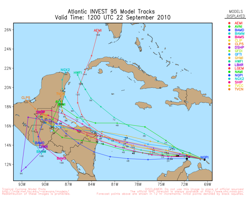
DISTURBANCE INVEST (AL952010) 20100922 0600 UTC
...00 HRS... ...12 HRS... ...24 HRS. .. ...36 HRS...
100922 0600 100922 1800 100923 0600 100923 1800
LAT LON LAT LON LAT LON LAT LON
BAMS 12.5N 67.5W 12.9N 70.0W 13.2N 72.6W 13.7N 75.2W
BAMD 12.5N 67.5W 12.6N 69.8W 12.5N 72.2W 12.4N 74.6W
BAMM 12.5N 67.5W 12.8N 69.8W 12.9N 72.1W 13.1N 74.6W
LBAR 12.5N 67.5W 13.0N 70.3W 13.5N 73.4W 14.0N 76.6W
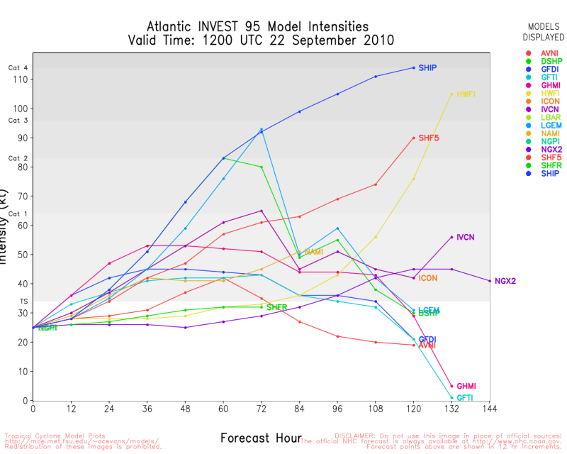
SHIP 25KTS 28KTS 35KTS 48KTS
DSHP 25KTS 28KTS 35KTS 48KTS
...48 HRS... ...72 HRS... ...96 HRS. .. ..120 HRS...
100924 0600 100925 0600 100926 0600 100927 0600
LAT LON LAT LON LAT LON LAT LON
BAMS 14.0N 77.6W 14.7N 82.4W 15.9N 86.4W 16.8N 88.4W
BAMD 12.4N 77.0W 12.9N 81.4W 14.7N 85.1W 16.6N 87.6W
BAMM 13.4N 77.1W 14.1N 81.8W 15.5N 86.3W 16.6N 88.8W
LBAR 14.7N 79.9W 16.1N 86.3W 15.7N 86.8W 16.8N 89.1W
SHIP 63KTS 89KTS 106KTS 115KTS
DSHP 63KTS 89KTS 43KTS 40KTS
...INITIAL CONDITIONS...
LATCUR = 12.5N LONCUR = 67.5W DIRCUR = 275DEG SPDCUR = 15KT
LATM12 = 12.2N LONM12 = 64.0W DIRM12 = 275DEG SPDM12 = 12KT
LATM24 = 12.1N LONM24 = 61.6W
WNDCUR = 25KT RMAXWD = 60NM WNDM12 = 25KT
CENPRS = 1009MB OUTPRS = 1011MB OUTRAD = 170NM SDEPTH = S
RD34NE = 0NM RD34SE = 0NM RD34SW = 0NM RD34NW = 0NM
Carla/Alicia/Jerry(In The Eye)/Michelle/Charley/Ivan/Dennis/Katrina/Rita/Wilma/Humberto/Ike/Harvey
Member: National Weather Association
Facebook.com/Weather Infinity
Twitter @WeatherInfinity
Member: National Weather Association
Facebook.com/Weather Infinity
Twitter @WeatherInfinity
-
srainhoutx
- Site Admin
- Posts: 19700
- Joined: Tue Feb 02, 2010 2:32 pm
- Location: Maggie Valley, NC
- Contact:
95L is moving quickly WNW at a low latitiude this morning within the strong easterly flow. Guidance suggests it will slow down in a day or so. The question I have is will it be onshore of Nicaragua/Honduras, or just offshore that the meandering begins?
Carla/Alicia/Jerry(In The Eye)/Michelle/Charley/Ivan/Dennis/Katrina/Rita/Wilma/Humberto/Ike/Harvey
Member: National Weather Association
Facebook.com/Weather Infinity
Twitter @WeatherInfinity
Member: National Weather Association
Facebook.com/Weather Infinity
Twitter @WeatherInfinity
-
srainhoutx
- Site Admin
- Posts: 19700
- Joined: Tue Feb 02, 2010 2:32 pm
- Location: Maggie Valley, NC
- Contact:
HPC thoughts this morning:
DOWN SOUTH...THE DETERMINISTIC AND ENSEMBLE GUIDANCE CONTINUE TO
ADVERTISE A SYSTEM LIFTING OUT OF THE WESTERN CARIBBEAN /INVEST
95L/ TO THE NORTH ACROSS EITHER THE YUCATAN CHANNEL OR WESTERN
CUBA BY MID NEXT WEEK. THE 00Z CANADIAN WAS BY FAR THE
STRONGEST/LARGEST WITH THIS SYSTEM...AND WAS DISCOUNTED.
CONSIDERING THE TRENDS ACROSS THE MIDWEST/EAST...IT APPEARS THAT
THIS SYSTEM WOULD BE HEADED NORTH TO NORTHEAST INTO THE SOUTHEAST
GULF OF MEXICO/WESTERN FLORIDA STRAITS TOWARDS THE NORTHEAST GULF
COAST/FLORIDA IN 7-10 DAYS. THE DETAILS WILL BE COORDINATED WITH
NHC AT 16Z. STAY TUNED.
Carla/Alicia/Jerry(In The Eye)/Michelle/Charley/Ivan/Dennis/Katrina/Rita/Wilma/Humberto/Ike/Harvey
Member: National Weather Association
Facebook.com/Weather Infinity
Twitter @WeatherInfinity
Member: National Weather Association
Facebook.com/Weather Infinity
Twitter @WeatherInfinity
-
srainhoutx
- Site Admin
- Posts: 19700
- Joined: Tue Feb 02, 2010 2:32 pm
- Location: Maggie Valley, NC
- Contact:
06Z HWRF...remains offshore of the Yucatan and moving without a stall...
Carla/Alicia/Jerry(In The Eye)/Michelle/Charley/Ivan/Dennis/Katrina/Rita/Wilma/Humberto/Ike/Harvey
Member: National Weather Association
Facebook.com/Weather Infinity
Twitter @WeatherInfinity
Member: National Weather Association
Facebook.com/Weather Infinity
Twitter @WeatherInfinity
-
Scott747
- Posts: 1648
- Joined: Tue Feb 23, 2010 9:56 am
- Location: Freeport/Surfside Beach
- Contact:
HWRF is one of the outliers to the E and the storm/area would need to start lifting WNW/NW immediately to verify. Right now and going by what a track the NHC might show currently, it would move across part of Honduras, back over the water and into the YP with a bearish intensity forecast. With only a small deviation needed in track it would change by a significant margin. Would be some entertaining discos if they have to write any during the next few days.
http://i836.photobucket.com/albums/zz29 ... 1285166461
http://i836.photobucket.com/albums/zz29 ... 1285166580
http://i836.photobucket.com/albums/zz29 ... 1285166461
http://i836.photobucket.com/albums/zz29 ... 1285166580