
Hurricane Beryl
-
DoctorMu

- Posts: 8048
- Joined: Sun Jun 28, 2015 11:58 am
- Location: College Station
- Contact:
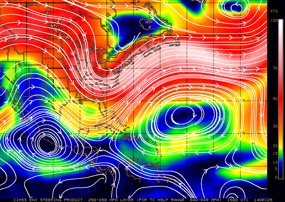
Beastmode, laughing at the shear...from global windmap. Beryl is just redirecting the easterly winds like a Greek goddess on Olympus.
- Attachments
-
- windmap.jpg
- (1.38 MiB) Downloaded 1985 times
-
cperk
- Posts: 858
- Joined: Sun Aug 19, 2012 12:09 pm
- Location: Richmond
- Contact:
Just saw Director Brennan on a utube update and toward the end of the video he was not yammering about a Mexico landfall he said the track will depend on Beryl's intensity and where it's at when it enters the gulf.He also mentioned that it's weakening at a slow pace.
-
jabcwb2
- Posts: 232
- Joined: Thu Feb 04, 2010 5:43 am
- Location: Houston 77066
- Contact:
Can someone post a continuous loop of Beryl? Perhaps every couple of pages? Thank you in advance!
-
DoctorMu
- Posts: 8048
- Joined: Sun Jun 28, 2015 11:58 am
- Location: College Station
- Contact:
Beryl appears to have some protective high pressure overhead as protective bubble. The current rector would take Beryl just north of Jamaica (instead of south). The path is expended to bend a little less NW, but don't sleep on Beryl.


-
sambucol

- Posts: 1244
- Joined: Wed Feb 03, 2010 5:43 pm
- Location: Mont Belvieu
- Contact:
-
DoctorMu
- Posts: 8048
- Joined: Sun Jun 28, 2015 11:58 am
- Location: College Station
- Contact:
Seeing 145 knots in latest reconnaissance. Is this confirmed?
-
DoctorMu
- Posts: 8048
- Joined: Sun Jun 28, 2015 11:58 am
- Location: College Station
- Contact:
So assuming the ridge moves east...
-
sambucol
- Posts: 1244
- Joined: Wed Feb 03, 2010 5:43 pm
- Location: Mont Belvieu
- Contact:
-
DoctorMu
- Posts: 8048
- Joined: Sun Jun 28, 2015 11:58 am
- Location: College Station
- Contact:
In looking back at the thread, models, and prediction Beryl was initialized far too south (100-200 miles). The built in bias reminds me of the misplaced College Football Playoff polls and their misplaced love affair with Ohio State.
-
Rip76

- Posts: 2133
- Joined: Mon Feb 15, 2010 12:38 am
- Location: The Woodlands
- Contact:
-
DoctorMu
- Posts: 8048
- Joined: Sun Jun 28, 2015 11:58 am
- Location: College Station
- Contact:
Beryl would curve north and sooner. Where it would make landfall because of the acute angle is anyone's guess - from north of Tampico to the Sabine River would be in play. We won't know until after Beryl clears Jamaica.
-
Stratton20
- Posts: 5827
- Joined: Tue Feb 09, 2021 11:35 pm
- Location: College Station, Texas
- Contact:
Pressure went from 950 mb down to 946 mb now
-
sswinney
- Posts: 64
- Joined: Thu Aug 24, 2017 3:29 pm
- Location: League City
- Contact:
-
DoctorMu
- Posts: 8048
- Joined: Sun Jun 28, 2015 11:58 am
- Location: College Station
- Contact:
From about 7:30 pm
386
URNT12 KNHC 030045
VORTEX DATA MESSAGE AL022024
A. 03/00:00:00Z
B. 16.06 deg N 071.81 deg W
C. 700 mb 2662 m
D. 949 mb
E. 160 deg 8 kt
F. Closed
G. C20
H. 134 kt
I. 007 deg 13 nm 23:55:00Z
J. 093 deg 145 kt
K. 007 deg 13 nm 23:55:00Z
L. 96 kt
M. 134 deg 8 nm 00:07:00Z
N. 216 deg 110 kt
O. 132 deg 4 nm 00:05:30Z
P. 9 C / 3034 m
Q. 16 C / 3046 m
R. 12 C / NA
S. 1234 / 07
T. 0.02 / 1 nm
U. AF302 1102A BERYL OB 04
MAX FL WIND 145 KT 007 / 13 NM 23:55:00Z
MAX FL TEMP 17 C 020 / 8 NM FROM FL CNTR
;
-
sswinney
- Posts: 64
- Joined: Thu Aug 24, 2017 3:29 pm
- Location: League City
- Contact:
Yeah I see it now. I guess tropical tidbits is a little behind.DoctorMu wrote: ↑Tue Jul 02, 2024 9:36 pmFrom about 7:30 pm
386
URNT12 KNHC 030045
VORTEX DATA MESSAGE AL022024
A. 03/00:00:00Z
B. 16.06 deg N 071.81 deg W
C. 700 mb 2662 m
D. 949 mb
E. 160 deg 8 kt
F. Closed
G. C20
H. 134 kt
I. 007 deg 13 nm 23:55:00Z
J. 093 deg 145 kt
K. 007 deg 13 nm 23:55:00Z
L. 96 kt
M. 134 deg 8 nm 00:07:00Z
N. 216 deg 110 kt
O. 132 deg 4 nm 00:05:30Z
P. 9 C / 3034 m
Q. 16 C / 3046 m
R. 12 C / NA
S. 1234 / 07
T. 0.02 / 1 nm
U. AF302 1102A BERYL OB 04
MAX FL WIND 145 KT 007 / 13 NM 23:55:00Z
MAX FL TEMP 17 C 020 / 8 NM FROM FL CNTR
;
- Attachments
-
- IMG_3066.jpeg
- (463.51 KiB) Downloaded 1807 times
Been here for years since Katrina.
-
Cpv17
- Posts: 7095
- Joined: Fri Aug 31, 2018 1:58 pm
- Location: El Campo/Wharton
- Contact:
Oof HWRF 
-
Pas_Bon
- Posts: 954
- Joined: Tue Sep 11, 2018 7:58 am
- Location: League City, TX
- Contact:
Lol
Geaux Tigers.
To keep it on the rails, Beryl is now much stronger than forecast at this point. She is also north of guidance. Eyes peeled, Middle/Upper TX coast…..
Last edited by Pas_Bon on Tue Jul 02, 2024 9:56 pm, edited 1 time in total.
-
biggerbyte
- Posts: 1439
- Joined: Thu Feb 04, 2010 12:15 am
- Location: Porter, Texas. (Montgomery County)
- Contact:
It does, did have the protection you are speaking about. That high is supposed to not move as Beryl continues on westward.
-
Rip76
- Posts: 2133
- Joined: Mon Feb 15, 2010 12:38 am
- Location: The Woodlands
- Contact:
Looks like a WSW jog there.