
June 2024
-
DoctorMu

- Posts: 8091
- Joined: Sun Jun 28, 2015 11:58 am
- Location: College Station
- Contact:
Dang it, I see a Lucy gap opening up.
-
Rip76

- Posts: 2151
- Joined: Mon Feb 15, 2010 12:38 am
- Location: The Woodlands
- Contact:
That’s a funny saying.
“Did y’all get any rain from that storm complex?”
“Nah man, we got Lucy Gapped.”

“Did y’all get any rain from that storm complex?”
“Nah man, we got Lucy Gapped.”

-
Stratton20
- Posts: 5870
- Joined: Tue Feb 09, 2021 11:35 pm
- Location: College Station, Texas
- Contact:
18z GEFS coming in more aggressive with BOC development, looks like a fire hose of moisture is coming our way!
-
DoctorMu
- Posts: 8091
- Joined: Sun Jun 28, 2015 11:58 am
- Location: College Station
- Contact:
Euro AI is enjoying itself far too much...

-
Stratton20
- Posts: 5870
- Joined: Tue Feb 09, 2021 11:35 pm
- Location: College Station, Texas
- Contact:
06z GFS shows a significant rain event for the houston metro area and to the south
- Attachments
-
- IMG_3144.png
- (369.7 KiB) Downloaded 2477 times
-
Cromagnum
- Posts: 3076
- Joined: Thu Feb 03, 2011 10:42 pm
- Location: Georgetown
- Contact:
When is all of this suppose to start?
-
Stratton20
- Posts: 5870
- Joined: Tue Feb 09, 2021 11:35 pm
- Location: College Station, Texas
- Contact:
Cromagnum time frame looks like Monday-Thursday next week
-
sswinney
- Posts: 64
- Joined: Thu Aug 24, 2017 3:29 pm
- Location: League City
- Contact:
Are we going to get this all in one shot like over 8 hours or are we looking at an extended period of days of rain? Less flooding of homes if the rain plays out over an extended period than a few hours.
Been here for years since Katrina.
-
Cpv17
- Posts: 7109
- Joined: Fri Aug 31, 2018 1:58 pm
- Location: El Campo/Wharton
- Contact:
-
DoctorMu
- Posts: 8091
- Joined: Sun Jun 28, 2015 11:58 am
- Location: College Station
- Contact:
Euro, GFS, CMC all bring 1-2 weak tropical systems into the Western Gulf next week.

-
Cpv17
- Posts: 7109
- Joined: Fri Aug 31, 2018 1:58 pm
- Location: El Campo/Wharton
- Contact:
This is going to be a very complex forecast to figure out for next week. Lots of uncertainties. Just have to wait a few days till we get a clearer picture.
-
DoctorMu
- Posts: 8091
- Joined: Sun Jun 28, 2015 11:58 am
- Location: College Station
- Contact:
Weaksauce shower heading Houston's way. We had maybe a tenth of an inch. Better than nothing. It's cloudy and not hot - the way I like summers in SETX.
Last edited by DoctorMu on Wed Jun 12, 2024 2:09 pm, edited 1 time in total.
-
mcheer23
- Global Moderator

- Posts: 607
- Joined: Fri Jan 11, 2013 11:15 am
- Location: Missouri City/ Sugar Land
- Contact:
Heavy rain off toward Fort Bend and Wharton counties...hopefully it makes it toward Sugar Land...
GFS dropped heavy rainfall totals for Monday and Tuesday...keeps about 2 inches along the coast...
GFS dropped heavy rainfall totals for Monday and Tuesday...keeps about 2 inches along the coast...
-
Rip76
- Posts: 2151
- Joined: Mon Feb 15, 2010 12:38 am
- Location: The Woodlands
- Contact:
I figured that would happen. Is there high pressure blocking?
-
Stratton20
- Posts: 5870
- Joined: Tue Feb 09, 2021 11:35 pm
- Location: College Station, Texas
- Contact:
Rip76 yes the high builds in while the system tries to lift north which is why it gets sent into mexico, however its still 7-8 days out so their is plenty of time for the strength, position of that heat ridge to change which can affect this systems track
-
Cpv17
- Posts: 7109
- Joined: Fri Aug 31, 2018 1:58 pm
- Location: El Campo/Wharton
- Contact:
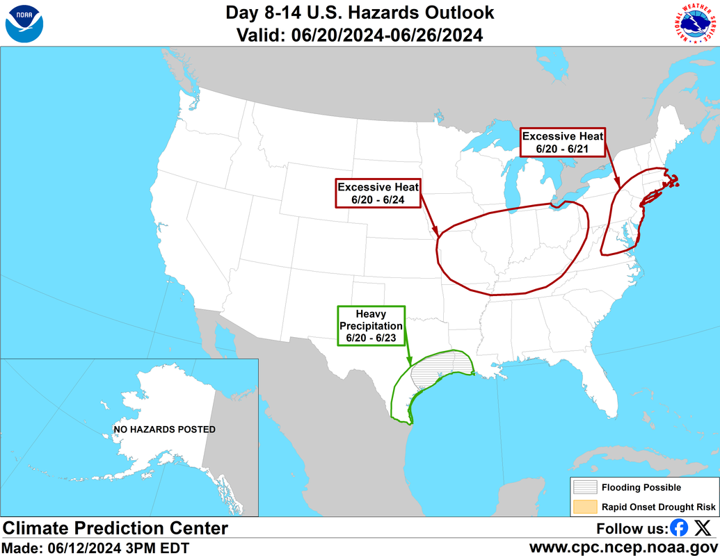
I’ll just leave this here:
-
DoctorMu
- Posts: 8091
- Joined: Sun Jun 28, 2015 11:58 am
- Location: College Station
- Contact:
-
Stratton20
- Posts: 5870
- Joined: Tue Feb 09, 2021 11:35 pm
- Location: College Station, Texas
- Contact:
Noticeable weaker heat ridge on the 18z GFS, a bit more of a weakness over texas, potentially allowing for an avenue for the system to move northward, doesnt on this run yet, but a bit more of a weakness is showing up on the GFS, something to watch in future runs
-
djmike

- Posts: 1883
- Joined: Fri Jan 07, 2011 12:19 pm
- Location: BEAUMONT, TX
- Contact:
Local mets in Beaumont already calling it a done deal it being too far south for any significant moisture for SETX. I think we still have days for this to change.
Mike
Beaumont, TX
(IH-10 & College Street)
Beaumont, TX
(IH-10 & College Street)
-
Stratton20
- Posts: 5870
- Joined: Tue Feb 09, 2021 11:35 pm
- Location: College Station, Texas
- Contact:
Herzog said their is a pathway for this system to take towards texas, said faster development and further north would allow the system to track more towards the texas coast,