June 2024
- DoctorMu
- Posts: 7803
- Joined: Sun Jun 28, 2015 11:58 am
- Location: College Station
- Contact:
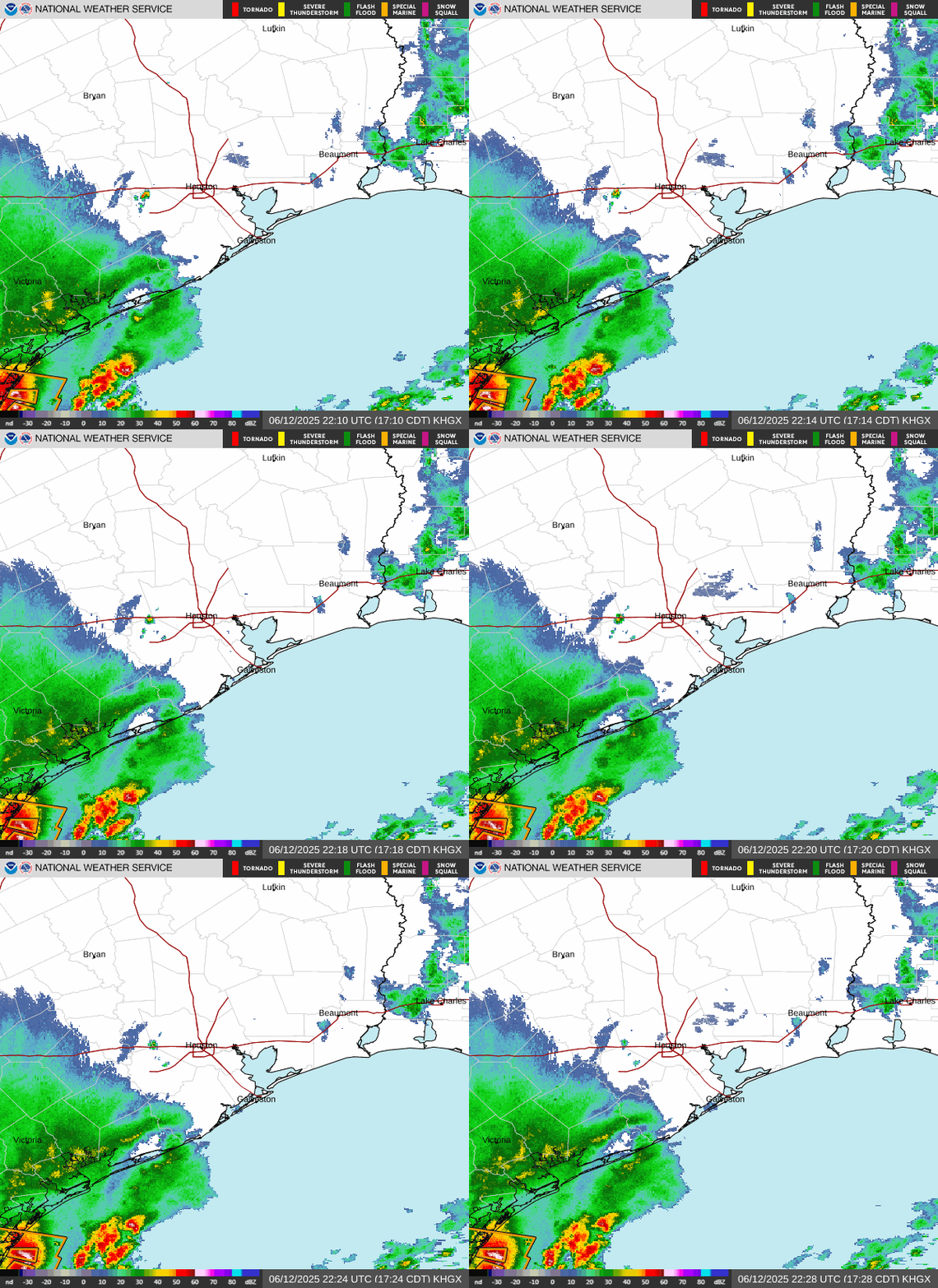
Houston, we have contact. Crossing I-10 sighting!


- jasons2k
- Posts: 6144
- Joined: Thu Feb 04, 2010 12:54 pm
- Location: Imperial Oaks
- Contact:
You don’t see this every day in June.
- Attachments
-
- IMG_2004.jpeg
- (753.33 KiB) Downloaded 3660 times
- DoctorMu
- Posts: 7803
- Joined: Sun Jun 28, 2015 11:58 am
- Location: College Station
- Contact:
Some backbuilding showers for us.
Haha, yeah our DP tanked by 10°F
Haha, yeah our DP tanked by 10°F
-
Pas_Bon
- Posts: 923
- Joined: Tue Sep 11, 2018 7:58 am
- Location: League City, TX
- Contact:
WUnderground still showing 56% chance of precip in League City at 10:41am.
LOL
It's pouring. These things are a joke when they're a joke.
LOL
It's pouring. These things are a joke when they're a joke.
- DoctorMu
- Posts: 7803
- Joined: Sun Jun 28, 2015 11:58 am
- Location: College Station
- Contact:
When Nowcasting is Nowcasting:
- Attachments
-
- WeatherRock.jpeg (177.75 KiB) Viewed 4283 times
-
Cpv17
- Posts: 6953
- Joined: Fri Aug 31, 2018 1:58 pm
- Location: El Campo/Wharton
- Contact:
I stopped using WUnderground for forecasts several years ago. The only time I ever got on there within the past few years was to read the hurricane discussion chats after Dr. Masters would post his tropical discussion articles. There were always some good chats on there. Not sure if that feature is even available anymore. Haven’t been able to find it, but honestly I stopped looking for it a few years ago.
- tireman4
- Global Moderator

- Posts: 6914
- Joined: Wed Feb 03, 2010 9:24 pm
- Location: Humble, Texas
- Contact:
Severe Thunderstorm Warning
- Attachments
-
- Severe Thunderstorm Warning 06 05 24.jpg (100.85 KiB) Viewed 4268 times
- don
- Posts: 3133
- Joined: Wed Feb 03, 2010 3:33 pm
- Location: Wichita Falls
- Contact:
I'm loving this wet Spring weather! 
-
cperk
- Posts: 850
- Joined: Sun Aug 19, 2012 12:09 pm
- Location: Richmond
- Contact:
-
Pas_Bon
- Posts: 923
- Joined: Tue Sep 11, 2018 7:58 am
- Location: League City, TX
- Contact:
Sadly, it's not available any longer.Cpv17 wrote: ↑Wed Jun 05, 2024 11:13 amI stopped using WUnderground for forecasts several years ago. The only time I ever got on there within the past few years was to read the hurricane discussion chats after Dr. Masters would post his tropical discussion articles. There were always some good chats on there. Not sure if that feature is even available anymore. Haven’t been able to find it, but honestly I stopped looking for it a few years ago.
-
Cpv17
- Posts: 6953
- Joined: Fri Aug 31, 2018 1:58 pm
- Location: El Campo/Wharton
- Contact:
That’s unfortunate. I always looked forward to going on there and catching up on everything. My main takeaway from that place was a poster on there named Wunderkidcayman and how badly he wanted every storm to go towards the Cayman Islands lolPas_Bon wrote: ↑Wed Jun 05, 2024 1:14 pmSadly, it's not available any longer.Cpv17 wrote: ↑Wed Jun 05, 2024 11:13 amI stopped using WUnderground for forecasts several years ago. The only time I ever got on there within the past few years was to read the hurricane discussion chats after Dr. Masters would post his tropical discussion articles. There were always some good chats on there. Not sure if that feature is even available anymore. Haven’t been able to find it, but honestly I stopped looking for it a few years ago.
- DoctorMu
- Posts: 7803
- Joined: Sun Jun 28, 2015 11:58 am
- Location: College Station
- Contact:
Suspending sprinkler action is my favorite part, right behind 74°F and DP down into the 60s!
Could be perfect for a mow this evening. We had 0.68 inches of rain. Good enough!
-
davidiowx
- Posts: 1185
- Joined: Thu Jan 23, 2014 2:39 pm
- Location: Richmond, TX
- Contact:
Ha I remember those days. If I recall correctly, Levi Cowan was on there all the time before he got his degree. I remember when the first started tropical tidbits. Another poster I remember was Patrap. He had some good stuff tooCpv17 wrote: ↑Wed Jun 05, 2024 1:51 pmThat’s unfortunate. I always looked forward to going on there and catching up on everything. My main takeaway from that place was a poster on there named Wunderkidcayman and how badly he wanted every storm to go towards the Cayman Islands lolPas_Bon wrote: ↑Wed Jun 05, 2024 1:14 pmSadly, it's not available any longer.Cpv17 wrote: ↑Wed Jun 05, 2024 11:13 am
I stopped using WUnderground for forecasts several years ago. The only time I ever got on there within the past few years was to read the hurricane discussion chats after Dr. Masters would post his tropical discussion articles. There were always some good chats on there. Not sure if that feature is even available anymore. Haven’t been able to find it, but honestly I stopped looking for it a few years ago.
- Ptarmigan
- Statistical Specialist

- Posts: 4470
- Joined: Wed Feb 03, 2010 7:20 pm
- Contact:
Those storms came out of nowhere. The rain keeps things cool.
-
869MB
- Posts: 204
- Joined: Fri Oct 30, 2015 8:44 am
- Location: Katy, TX
- Contact:
davidiowx wrote: ↑Wed Jun 05, 2024 4:57 pmHa I remember those days. If I recall correctly, Levi Cowan was on there all the time before he got his degree. I remember when the first started tropical tidbits. Another poster I remember was Patrap. He had some good stuff too
Yes Levi was a regular on there for a few years before he began pursuing his degrees (I think he began chatting towards the end of 2005 to be exact, because I joined as a member earlier that year before the season got crazy). There were quite a few quality participants on that forum that were knowledgeable concerning tropical weather.
-
Cpv17
- Posts: 6953
- Joined: Fri Aug 31, 2018 1:58 pm
- Location: El Campo/Wharton
- Contact:
Yep, I’m pretty sure I remember him too. The name sounds very familiar. I miss that place. Learned a lot there.davidiowx wrote: ↑Wed Jun 05, 2024 4:57 pmHa I remember those days. If I recall correctly, Levi Cowan was on there all the time before he got his degree. I remember when the first started tropical tidbits. Another poster I remember was Patrap. He had some good stuff too
- tireman4
- Global Moderator

- Posts: 6914
- Joined: Wed Feb 03, 2010 9:24 pm
- Location: Humble, Texas
- Contact:
115
FXUS64 KHGX 061150
AFDHGX
Area Forecast Discussion
National Weather Service Houston/Galveston TX
650 AM CDT Thu Jun 6 2024
...New AVIATION...
.SHORT TERM...
(Today through Friday Night)
Issued at 316 AM CDT Thu Jun 6 2024
For the most part, warm quiet weather will prevail across SE TX for
the short term. Ridging aloft will continue to amplify across W TX/
NM the next couple of days with weak surface high pressure persist-
ing over the region. Slightly lower dewpoints (in the wake of a now
stationary boundary) along with the mostly clear skies will help to
give us warm (slightly above normal) daytime temperatures (highs in
the lower to mid 90s) with heat index values ranging from 100F-105F
during the afternoons. Lows tonight will be in the lower 70s across
much of the CWA (to the upper 70s at the immediate coast). A return
of light onshore winds could add a couple of degrees to these read-
ings for tomorrow night. 41
&&
.LONG TERM...
(Saturday through Wednesday)
Issued at 316 AM CDT Thu Jun 6 2024
The dominant upper ridge will remain in place through the weekend,
with hot and humid but otherwise rain-free conditions expected to
prevail through Sunday. Diurnal thunderstorm activity will
struggle to develop under the influence of a pronounced midlevel
capping inversion, which has kept the PoP forecast near zero
through the end of the weekend. The main concern instead will be
heat, with high temperatures on both days reaching the low to mid
90s while dew points sit in the low to mid 70s. While this will
produce maximum heat index values of around 105 (below our
advisory threshold), relatively light winds and mostly clear
skies may aggravate potential heat exposure. As such, heat safety
measures should still be considered.
A pattern shift arrives on Monday, with global models remaining in
agreement in depicting the approach of a cold front extending from
a surface low over the Northeastern CONUS early on Monday. While
the boundary appears likely to stall out before reaching the
coast, it will nonetheless bring a chance of widespread showers
and storms throughout the day on Monday. That being said, we
currently do not anticipate a severe weather and/or flooding
threat. An active pattern will take hold into at least the middle
part of next week as a robust midlevel trough swings into the
South Central CONUS. As the aforementioned boundary continues to
linger over the area, additional showers and storms will be
possible. Expect high temperatures a few degrees lower to start
off the week, with most locations in the upper 80s to near 90. Low
temperatures should continue to remain mainly in the low to mid
70s.
&&
.AVIATION...
(12Z TAF Issuance)
Issued at 645 AM CDT Thu Jun 6 2024
Patchy fog should mix out by mid morning with only high clouds ex-
pected through the rest of today. We could see a return of patchy
fog tonight. Otherwise, VFR. 41
&&
.MARINE...
Issued at 316 AM CDT Thu Jun 6 2024
Lighter winds and lower seas will prevail through the weekend.
There will be a chance for some patchy fog tonight, but
visibilities should not get low enough as to require any fog
advisories. There remains a risk of rip currents through the rest
of the day today. Heading into next week, a more active weather
pattern will develop with chances of thunderstorms returning to
the forecast beginning on Monday and prevailing through at least
Wednesday.
Cady
&&
.PRELIMINARY POINT TEMPS/POPS...
College Station (CLL) 93 71 95 73 / 0 0 0 0
Houston (IAH) 95 74 96 74 / 0 0 0 0
Galveston (GLS) 89 79 89 79 / 0 0 0 0
&&
.HGX WATCHES/WARNINGS/ADVISORIES...
TX...High Rip Current Risk through this evening for TXZ436>439.
GM...None.
&&
$$
SHORT TERM...41
LONG TERM....Cady
AVIATION...41
MARINE...Cady
-
Pas_Bon
- Posts: 923
- Joined: Tue Sep 11, 2018 7:58 am
- Location: League City, TX
- Contact:
- Rip76
- Posts: 2106
- Joined: Mon Feb 15, 2010 12:38 am
- Location: The Woodlands
- Contact:
- DoctorMu
- Posts: 7803
- Joined: Sun Jun 28, 2015 11:58 am
- Location: College Station
- Contact:
NE winds this afternoon have mixed down some dry air. The haze is gone. DP in the 60s, even in Houston. Temps of 90°F. A July afternoon in NC.
I'll allow it!
I'll allow it!
