
May 2024
-
jasons2k

- Posts: 6201
- Joined: Thu Feb 04, 2010 12:54 pm
- Location: Imperial Oaks
- Contact:
Geez it’s hot
- Attachments
-
- IMG_1815.jpeg
- (2.78 MiB) Downloaded 2920 times
-
DoctorMu

- Posts: 8091
- Joined: Sun Jun 28, 2015 11:58 am
- Location: College Station
- Contact:
I guess we're the firehose that will be feeding those tornadic cells in north Texas, OK, KS that are beginning to erupt around the dry line:
Temp: 96.1°F
DP: 81.1°F
Heat Index: 119.3°F
https://youtu.be/xeSwrFKFNFw?si=vWyqG0iJyLdhTh8o
lol Jason beat me to it as I was linking the SNL hot tub skit.
Temp: 96.1°F
DP: 81.1°F
Heat Index: 119.3°F
https://youtu.be/xeSwrFKFNFw?si=vWyqG0iJyLdhTh8o
lol Jason beat me to it as I was linking the SNL hot tub skit.
-
DoctorMu
- Posts: 8091
- Joined: Sun Jun 28, 2015 11:58 am
- Location: College Station
- Contact:
Update:
Temp: 96.3°F
DP: 81.7°F (highest I've recorded here so far)
Heat Index: 120.1°F
Temp: 96.3°F
DP: 81.7°F (highest I've recorded here so far)
Heat Index: 120.1°F
-
Cpv17
- Posts: 7109
- Joined: Fri Aug 31, 2018 1:58 pm
- Location: El Campo/Wharton
- Contact:
95°F here with a feels like of 106°F. DP of 73°.
Glad I don’t live where y’all do.
Glad I don’t live where y’all do.
-
Cromagnum
- Posts: 3076
- Joined: Thu Feb 03, 2011 10:42 pm
- Location: Georgetown
- Contact:
Off to the Space Cowboys game. Gonna sweat my tail off.
-
Cpv17
- Posts: 7109
- Joined: Fri Aug 31, 2018 1:58 pm
- Location: El Campo/Wharton
- Contact:
The 12z Euro is literally just a tease for me.
-
Cpv17
- Posts: 7109
- Joined: Fri Aug 31, 2018 1:58 pm
- Location: El Campo/Wharton
- Contact:
-
Stratton20
- Posts: 5870
- Joined: Tue Feb 09, 2021 11:35 pm
- Location: College Station, Texas
- Contact:
Looks like wednesday may be the kick starter to a wettern pattern, NAM is sniffing out a disturbance moving through se texas
-
Pas_Bon
- Posts: 968
- Joined: Tue Sep 11, 2018 7:58 am
- Location: League City, TX
- Contact:
Stratton20 wrote: ↑Sat May 25, 2024 10:41 pm Looks like wednesday may be the kick starter to a wettern pattern, NAM is sniffing out a disturbance moving through se texas
God, I hope so
-
Pas_Bon
- Posts: 968
- Joined: Tue Sep 11, 2018 7:58 am
- Location: League City, TX
- Contact:
I grew up at a very similar latitude and mostly similar
climate in SW Louisiana.
It was hot in the Summer growing up, but I’m hard pressed to remember hating Summer this much. Lol.
Perhaps it’s just me getting older.
climate in SW Louisiana.
It was hot in the Summer growing up, but I’m hard pressed to remember hating Summer this much. Lol.
Perhaps it’s just me getting older.
-
Cpv17
- Posts: 7109
- Joined: Fri Aug 31, 2018 1:58 pm
- Location: El Campo/Wharton
- Contact:
Probably. The heat didn’t bother me much when I was a kid. It still doesn’t bother me that much to this day. Summer is still my favorite season actually. I can tolerate 100°F with a 112°F heat index much better than I can tolerate 30°F with a feels like of 18°F. Now if we’re talking what my favorite season is just purely based on weather then it would probably be fall.
-
Pas_Bon
- Posts: 968
- Joined: Tue Sep 11, 2018 7:58 am
- Location: League City, TX
- Contact:
Is anyone else having trouble accessing Storm2k forums?
-
Cpv17
- Posts: 7109
- Joined: Fri Aug 31, 2018 1:58 pm
- Location: El Campo/Wharton
- Contact:
-
DoctorMu
- Posts: 8091
- Joined: Sun Jun 28, 2015 11:58 am
- Location: College Station
- Contact:
One last hail producing cell 20 miles north of CLL is lurking this morning.
Horrible, violent tornadoes took their toll north of Denton and in NW Arkansas.
Horrible, violent tornadoes took their toll north of Denton and in NW Arkansas.
-
DoctorMu
- Posts: 8091
- Joined: Sun Jun 28, 2015 11:58 am
- Location: College Station
- Contact:
NWS has upped our rain chances to 40% beginning Tuesday night
Area Forecast Discussion
National Weather Service Houston/Galveston TX
637 AM CDT Sun May 26 2024
...New AVIATION...
.SHORT TERM...
(Today through Monday Night)
Issued at 415 AM CDT Sun May 26 2024
It`s been a pretty "rinse and repeat" forecast for the last few
days, and today`s forecast will continue the pattern of heat and
humidity as SE Texas remains under a broad area of high pressure
that is centered over Mexico. Daytime temperatures will continue to
top out in the low to mid 90s inland and in the 80s for the islands.
Dew point values in the mid to upper 70s will make today feel like
you are being wrapped in a hot and wet blanket...
Jokes aside, the combination of heat and humidity will lead to heat
index values reaching Advisory criteria (108 degrees and higher) for
much of SE Texas (with the exception of coastal counties and the
islands). Nighttime temperatures will not provide much relief from
the heat as temperatures lower into the 70s to around 80 degrees.
Heat index values at the time of this writing are in the upper 80s
to low 90s for much of the area. For this reason a Heat Advisory
will be in effect for this afternoon through Monday night.
Please remember to exercise caution with rising temperatures. Stay
hydrated, avoid strenuous activity during the hottest part of the
day, never leave children or pets in unattended vehicles (even if
you plan to crack a window, it is too hot!). For pet owners,
remember, it is too hot for the palm of your hand, the ground is too
hot for your pets` paws.
In addition to the heat, there is the potential for isolated strong
to severe thunderstorms across portions of SE Texas Monday (looking
like best chances may be in the nighttime hours). SPC has placed an
area generally along and north of I-10 in a Marginal Risk (level 1
of 5) for severe weather. A dry line will move into Central Texas
during the day Monday, at the 500mb level a few disturbances
embedded in the quasi-zonal flow will move through and provide
pockets of PVA. These storms would likely move in from Mexico and
push through Central Texas during the evening hours. Whether or not
the storms make it to SE Texas would largely depend on the erosion
of a pretty hefty capping inversion. If storms are able to break
through the cap, they will be met with CAPE in excess of 4000 J/kg,
LI values of around -10 to -14 (meaning a pretty volatile airmass is
in place), steep mid-level lapse rates, and decent amount of shear.
In layman`s terms, if storms overcome the cap, they would enter an
environment favorable for organized storms capable of producing
damaging winds (58 mph or greater) and large hail (1" or greater).
The greatest chance for thunderstorms would be in the western and
northern counties.
Once storms die down later on Monday night, expect partly to mostly
cloudy skies with lows in the 70s to near 80 degrees.
Finally, for those of you going to the beach, there is a high risk
of rip currents through the holiday weekend. Please swim near a
lifeguard and avoid swimming near rocks, piers and jetties as
this is where rip currents are more likely to form. If you find
yourself caught in a rip current, remember to wave, yell, and swim
parallel to the shore. In addition, don`t swim at the eastern or
western tips of Galveston Island. Tidal currents and rip currents
are always dangerous there. Galveston Beach Patrol made over a dozen
rescues yesterday and unfortunately we had one rip current
related drowning. The Beach Patrol is recommending adult
experienced swimmers only go no more than waist deep water - and
those non-swimmers with kids to stay on the beach.
Adams
&&
.LONG TERM...
(Tuesday through Saturday)
Issued at 415 AM CDT Sun May 26 2024
Unseasonably hot conditions will begin waning Tuesday as upper
ridging to our south begins losing a touch of its grip, heights
and H85/7 temps lower, and llvl winds trend more to the SE. A weak
backdoor front should be somewhat close to the region Tue (maybe
NE Tx and Ncntl La. Would anticipate some scattered tstm
development on its western periphery during the late afternoon/evening
hours. Better chances generally north of I-10 where the cap is
more likely to be overcome with any forcing. Eyes then turn to the
NW Tuesday night as a potential disturbance in the NW flow aloft
amplifies overnight into Wed with a possible MCS developing.
During the mid-late week time period, we should see another surge
of high pressure building SSE down the Midwest into the
Mississippi Valley. This well give the backdoor front a slightly
further westward push and some more recycled "drier" air into the
area. And by "drier" I mean temps/dewpoints trending back to near
normal.
With low level southeast flow in place we should still have plenty
of moisture available to fuel some shra/tstms. Some ridging aloft
won`t exactly make things ideal, but isolated-scattered diurnally
driven precip looks to be a decent bet...especially the further
inland from the coast one gets. Guidance still projecting a fairly
active NW flow aloft with embedded disturbances possibly enhancing
or generating another MCS or two upstream that`ll need to be
monitored. Confidence as to when/where remains low, but overall
pattern is somewhat favorable in regards to the possibility. 47
&&
-
dp6
- Posts: 116
- Joined: Sun May 24, 2020 5:32 pm
- Contact:
A major server farm in DFW lost power this morning and their switchover to generator failed. I don't know if they are hosted there, but possible. Wasn't from the overnight tornadoes but rather straight line winds of another line that blew in about dawn, having formed near San Angelo around midnight.
-
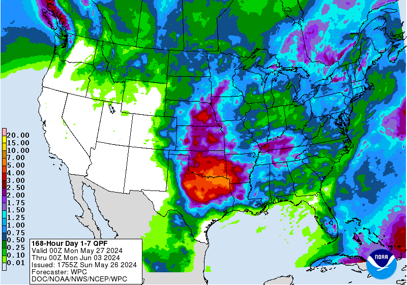
Cpv17
- Posts: 7109
- Joined: Fri Aug 31, 2018 1:58 pm
- Location: El Campo/Wharton
- Contact:
Another day with another north of I-10 special forecast from the WPC:

-
Stratton20
- Posts: 5870
- Joined: Tue Feb 09, 2021 11:35 pm
- Location: College Station, Texas
- Contact:
One thibg i will caution with the WPC rain map, I could easily see more rain in SE texas than what the map shows, especially with NW flow disturbances, the global models will likely underestimate those , lets see what happens when the short range models come into range
-
Stratton20
- Posts: 5870
- Joined: Tue Feb 09, 2021 11:35 pm
- Location: College Station, Texas
- Contact:
12z Euro has widespread 2-4 inches across se texas due a stalled out boundary focusing rain across central and se texas, very wet run
-
DoctorMu
- Posts: 8091
- Joined: Sun Jun 28, 2015 11:58 am
- Location: College Station
- Contact:
Most of the rain for the next 10-14 days still looks like more north of Hwy 79 or 1*5:
