
Very unsettling to see that. I could see records being made and broken.
2024 Hurricane Season Discussion
-
Ptarmigan

- Statistical Specialist

- Posts: 4536
- Joined: Wed Feb 03, 2010 7:20 pm
- Contact:
-
tireman4

- Global Moderator

- Posts: 7161
- Joined: Wed Feb 03, 2010 9:24 pm
- Location: Humble, Texas
- Contact:
Ocean Temperatures 2024
-
tireman4
- Global Moderator
- Posts: 7161
- Joined: Wed Feb 03, 2010 9:24 pm
- Location: Humble, Texas
- Contact:
Ocean Temperatures 2024
- Attachments
-
- Ocean Temperatures 2024.jpg (85.61 KiB) Viewed 9791 times
-
Pas_Bon
- Posts: 968
- Joined: Tue Sep 11, 2018 7:58 am
- Location: League City, TX
- Contact:
-
DoctorMu

- Posts: 8089
- Joined: Sun Jun 28, 2015 11:58 am
- Location: College Station
- Contact:
-
Cpv17
- Posts: 7109
- Joined: Fri Aug 31, 2018 1:58 pm
- Location: El Campo/Wharton
- Contact:
All I can tell you guys is watch the Caribbean Sea. Usually it’s a graveyard, but if it’s favorable this year, good chance we’re in big trouble.
-
Stratton20
- Posts: 5870
- Joined: Tue Feb 09, 2021 11:35 pm
- Location: College Station, Texas
- Contact:
Cpv17 that upper ocean heat content is really building in the Western Caribbean….. could get rough
-
Stratton20
- Posts: 5870
- Joined: Tue Feb 09, 2021 11:35 pm
- Location: College Station, Texas
- Contact:
Seeing widespread 29-30 degree celcius readings in the caribbean, all that energy just building….. It could get really rough folks
-
don

- Posts: 3148
- Joined: Wed Feb 03, 2010 3:33 pm
- Location: Wichita Falls
- Contact:
Wake up babe,Tropical Tidbits just posted a new video. LOL 
https://www.youtube.com/watch?v=QFID_jfNId4

https://www.youtube.com/watch?v=QFID_jfNId4
-
Stratton20
- Posts: 5870
- Joined: Tue Feb 09, 2021 11:35 pm
- Location: College Station, Texas
- Contact:
Don Levi Cowan is the best! I have a feeling hes going to be making alot of videos this season lol
-
Cromagnum
- Posts: 3076
- Joined: Thu Feb 03, 2011 10:42 pm
- Location: Georgetown
- Contact:
May turn into a real **** season. I don't know if "never been this hot in May before" is accurate though.
https://x.com/US_Stormwatch/status/1793401379861795095
https://x.com/US_Stormwatch/status/1793401379861795095
-
Cpv17
- Posts: 7109
- Joined: Fri Aug 31, 2018 1:58 pm
- Location: El Campo/Wharton
- Contact:
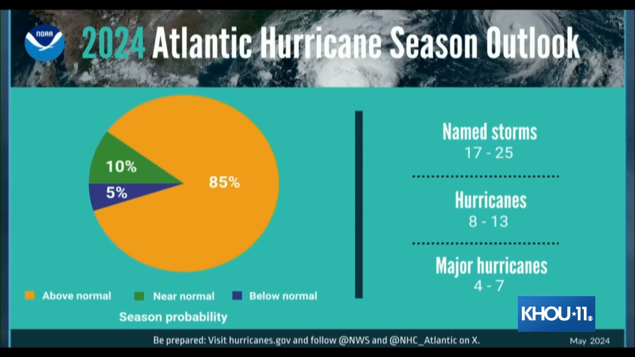
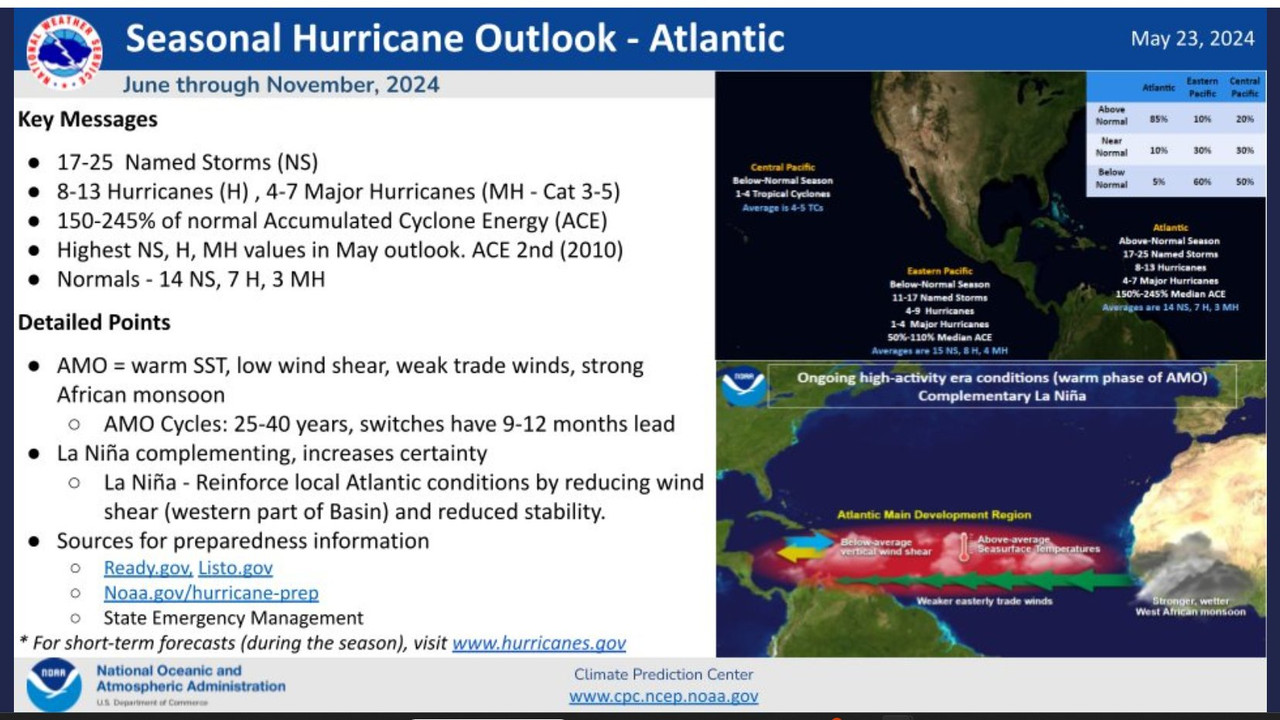
NOAA’s Hurricane Outlook:
-
tireman4
- Global Moderator
- Posts: 7161
- Joined: Wed Feb 03, 2010 9:24 pm
- Location: Humble, Texas
- Contact:
The Eyewall
@TheEyewallWx
·
18m
A tremendously aggressive forecast from NOAA this year. Add it to the litany of forecasts that say things similar. This is the year to be prepared and hope some kind of fail mode is realized.
@TheEyewallWx
·
18m
A tremendously aggressive forecast from NOAA this year. Add it to the litany of forecasts that say things similar. This is the year to be prepared and hope some kind of fail mode is realized.
-
Cpv17
- Posts: 7109
- Joined: Fri Aug 31, 2018 1:58 pm
- Location: El Campo/Wharton
- Contact:
Most aggressive May forecast ever put out by NOAA. Keep in mind, they’re conservative as well.
-
Pas_Bon
- Posts: 968
- Joined: Tue Sep 11, 2018 7:58 am
- Location: League City, TX
- Contact:
-
Stratton20
- Posts: 5870
- Joined: Tue Feb 09, 2021 11:35 pm
- Location: College Station, Texas
- Contact:
As Han Solo says “ I got a bad feeling about this”, buckle up folks
-
Stratton20
- Posts: 5870
- Joined: Tue Feb 09, 2021 11:35 pm
- Location: College Station, Texas
- Contact:
Upper ocean heat content map.. Folks if that isnt alarming, I dont know what is….
- Attachments
-
- IMG_3116.png
- (234.92 KiB) Downloaded 7404 times
-
don
- Posts: 3148
- Joined: Wed Feb 03, 2010 3:33 pm
- Location: Wichita Falls
- Contact:
Some alarming data...
- Ccdapture.PNG (43.74 KiB) Viewed 9457 times
ABC13-Travis Herzog
By the way, it was former National Hurricane Center Director Bill Read who first tipped me off to this astonishing correlation. There is a way to extend this data earlier than 1950 (although the data is not as sound), but the general correlations still hold up.
-
Pas_Bon
- Posts: 968
- Joined: Tue Sep 11, 2018 7:58 am
- Location: League City, TX
- Contact:
https://x.com/BenNollWeather/status/1793981601132798393
Ben Noll
@BenNollWeather
This map compares current sea surface temperature anomalies with the global average anomaly. Rather than using a 30-year normal to compute anomalies, this method more clearly reveals areas that are unusually warm or cool relative to the rest of the planet.
This is important toward understanding where thunderstorm activity (convection) will be favored.
The situation in the Atlantic really stands out, with widespread, anomalous warmth in the deep tropics and a cool patch toward the sub-tropics.
This configuration is highly favorable toward enabling rising air and convection in the Main Development Region (for hurricanes) and limiting it elsewhere in the basin.
Furthermore, a La Niña-like signature is maturing in the Pacific and a cool tongue is evident along the west coast of North America, characteristic of the negative phase of the Pacific Decadal Oscillation. These features will contribute to sinking air and suppressed convection in the Pacific, further propping up the Atlantic...

7:25 AM · May 24, 2024
·
1,892
Views
Ben Noll
@BenNollWeather
This map compares current sea surface temperature anomalies with the global average anomaly. Rather than using a 30-year normal to compute anomalies, this method more clearly reveals areas that are unusually warm or cool relative to the rest of the planet.
This is important toward understanding where thunderstorm activity (convection) will be favored.
The situation in the Atlantic really stands out, with widespread, anomalous warmth in the deep tropics and a cool patch toward the sub-tropics.
This configuration is highly favorable toward enabling rising air and convection in the Main Development Region (for hurricanes) and limiting it elsewhere in the basin.
Furthermore, a La Niña-like signature is maturing in the Pacific and a cool tongue is evident along the west coast of North America, characteristic of the negative phase of the Pacific Decadal Oscillation. These features will contribute to sinking air and suppressed convection in the Pacific, further propping up the Atlantic...
7:25 AM · May 24, 2024
·
1,892
Views
-
Pas_Bon
- Posts: 968
- Joined: Tue Sep 11, 2018 7:58 am
- Location: League City, TX
- Contact:
From Travis Herzog of ABC 13 in Houston...
By now you've probably seen the hurricane outlook NOAA released today calling for a very active season, but you may have never seen the eye-opening maps I'm posting for you here. One of the main drivers of the anticipated active hurricane season ahead is the transition from an El Nino ocean pattern to a La Nina Ocean pattern in the Pacific, but do you know how that specifically influences hurricane activity over Texas? It turns out that since 1950, there have only been 4 hurricane hits in Texas during a La Nina, NONE during an El Nino, but FOURTEEN hurricane hits in Texas during "La Nada," which is a non-technical name for the transitional phase between El Nino and La Nina. And half of those 14 hits occurred right here in Southeast Texas. In fact, when you look at the list of names that have hit Texas during "La Nada," there are some real bruisers like Alicia, Allen, Beulah, Carla, Harvey, Ike, and Rita. (Just take a look at the zoomed down maps.) What is the physical explanation for all of this? It boils down to steering currents. During an El NIno, the steering currents tend to push hurricanes away from Texas (or prevent tropical storms that do hit us from becoming hurricanes) while La Nina steering currents tend to favor pathways to Mexico and just east of Texas (think of Louisiana in 2020). But in between the El Nino and La Nina phases, the door is open wider than normal for hurricanes to slide into the Lone Star State. Does that mean Texas will get hit this season while in the transitional "La Nada" phase, or that a hurricane can never hit Texas during an El Nino? The answer to both of those questions is "no," but the correlations are such that there is an increased chance Texas could be impacted by hurricanes this year. And with waters in the main tropical development region of the Atlantic already as warm as they normally are in mid August, the risk of "rapidly intensifying" storms is already greater than normal, too. I sincerely hope this season defies expectations and is a resounding dud, but hope is not a good preparational strategy when it comes to any hurricane season. So please do what you can to prepare for the season ahead in case a storm tracks this way, and we'll do our part to keep you informed with all the facts you need to know in a non-sensational way in the months ahead. For more on NOAA's pre-season outlook released today, head here:
https://abc13.com/post/noaa-predicts-re ... /14861750/