
October 2023
-
jasons2k

- Posts: 6201
- Joined: Thu Feb 04, 2010 12:54 pm
- Location: Imperial Oaks
- Contact:
It has arrived. Images posted on S2K.
-
Cpv17
- Posts: 7109
- Joined: Fri Aug 31, 2018 1:58 pm
- Location: El Campo/Wharton
- Contact:
-
Cromagnum
- Posts: 3076
- Joined: Thu Feb 03, 2011 10:42 pm
- Location: Georgetown
- Contact:
Just a sprinkle south of I10. Not gonna get much of anything.
-
suprdav2
- Posts: 141
- Joined: Thu Feb 04, 2010 5:39 pm
- Location: Cypress, TX
- Contact:
I'm currently out of state, but radar looks like it's all missing Cypress. Forcefield seems to be working again. Haha!
-
don

- Posts: 3148
- Joined: Wed Feb 03, 2010 3:33 pm
- Location: Wichita Falls
- Contact:
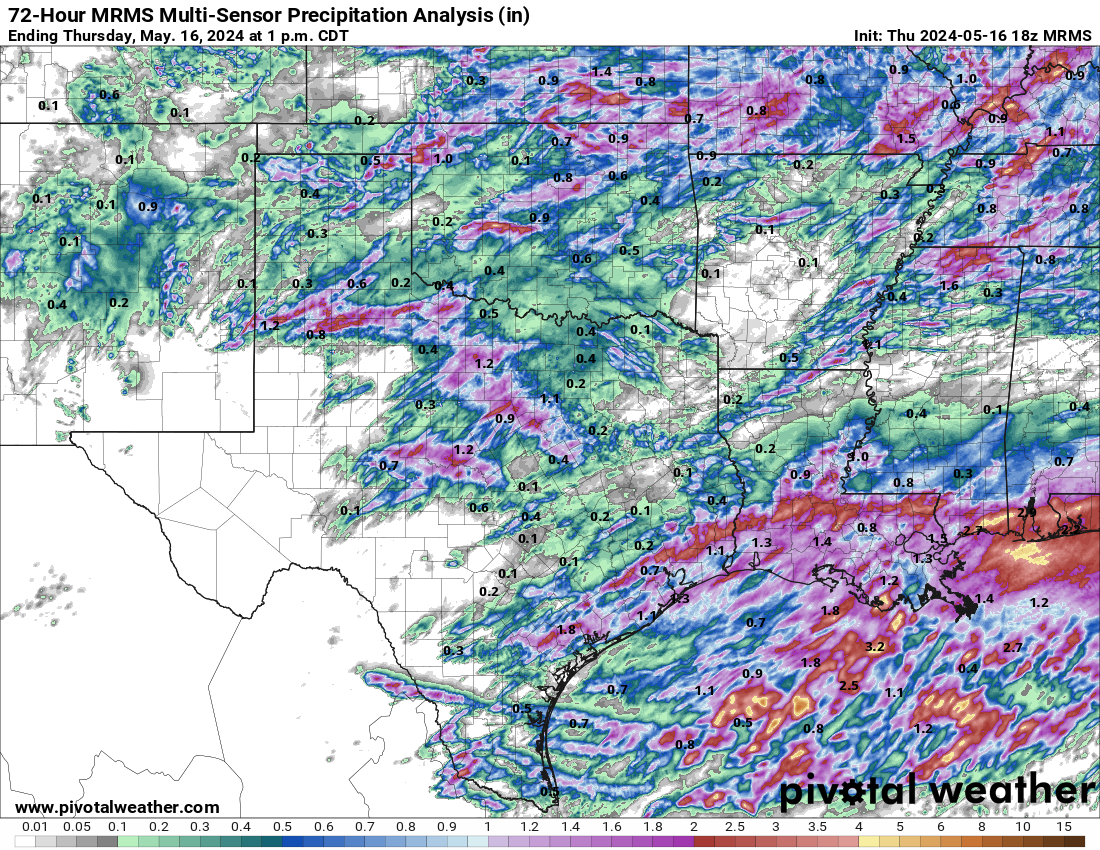
Theirs some rainfall amounts of up to 6" near Lake Conroe. Very hit or miss today in the area.Some places got pounded while other areas didn't receive a drop of rain.While not perfect, models did a pretty good job at depicting the rainfall disparity in the area. I received about .60" today.To my east 1-2 inches of rain fell today in the ship channel/Pasadena area and NE Houston.
-
Stratton20
- Posts: 5870
- Joined: Tue Feb 09, 2021 11:35 pm
- Location: College Station, Texas
- Contact:
Got about 1-1.5 inch here locally, next chance of rain looks to be ahead and behind our strong front, 00z NAM goes gung ho with a 1059 mb arctic high centered over colorado, unbelievable
-
Cpv17
- Posts: 7109
- Joined: Fri Aug 31, 2018 1:58 pm
- Location: El Campo/Wharton
- Contact:
If that verified then the CMC is onto something lolStratton20 wrote: ↑Thu Oct 26, 2023 10:22 pm Got about 1-1.5 inch here locally, next chance of rain looks to be ahead and behind our strong front, 00z NAM goes gung ho with a 1059 mb arctic high centered over colorado, unbelievable
-
DoctorMu

- Posts: 8089
- Joined: Sun Jun 28, 2015 11:58 am
- Location: College Station
- Contact:
Nam-a-Lam-a-Ding Dong

-
Ptarmigan

- Statistical Specialist

- Posts: 4536
- Joined: Wed Feb 03, 2010 7:20 pm
- Contact:
If that happened in the winter, it would be a major cold blast.Stratton20 wrote: ↑Thu Oct 26, 2023 4:17 pm lol the 18z NAM has a 1055 mb arctic high, now thats insane to see
-
Stratton20
- Posts: 5870
- Joined: Tue Feb 09, 2021 11:35 pm
- Location: College Station, Texas
- Contact:
The airmass is already colder real time compared to todays model runs, and its further south than some of the guidance, i wouldn’t be surprised to hear of a few sleet reports in our neck of the woods, this front means business, winter is making an early appearance
-
DoctorMu
- Posts: 8089
- Joined: Sun Jun 28, 2015 11:58 am
- Location: College Station
- Contact:
Looks like potentially a couple of nights in the 30s to begin November. 
Long overdue, but we finally hit or broke 1 inch of rainfall over the last day.
Long overdue, but we finally hit or broke 1 inch of rainfall over the last day.
-
DoctorMu
- Posts: 8089
- Joined: Sun Jun 28, 2015 11:58 am
- Location: College Station
- Contact:
More to come, especially NW of I-69/Hwy 59:

-
DoctorMu
- Posts: 8089
- Joined: Sun Jun 28, 2015 11:58 am
- Location: College Station
- Contact:
Presumably after the FROPA:


-
davidiowx
- Posts: 1197
- Joined: Thu Jan 23, 2014 2:39 pm
- Location: Richmond, TX
- Contact:
Is the front supposed to slow down? At this rate it looks like it would be here tonight instead of Sunday
-
brazoriatx
- Posts: 415
- Joined: Tue Nov 08, 2011 12:09 pm
- Contact:
I dont think that'd the front but I could be and probably will be wrong lol
Edit: I was wrong

Last edited by brazoriatx on Fri Oct 27, 2023 10:59 am, edited 1 time in total.
-
Stratton20
- Posts: 5870
- Joined: Tue Feb 09, 2021 11:35 pm
- Location: College Station, Texas
- Contact:
Front is moving quicker than current model guidance, NAM is 5-6 degrees colder than the GFS and Euro, and keeps lingering precipitation around for halloween, cant rule out some sleet either
-
Cromagnum
- Posts: 3076
- Joined: Thu Feb 03, 2011 10:42 pm
- Location: Georgetown
- Contact:
For College Station I'm assuming. No chance of that down here.Stratton20 wrote: ↑Fri Oct 27, 2023 10:50 am Front is moving quicker than current model guidance, NAM is 5-6 degrees colder than the GFS and Euro, and keeps lingering precipitation around for halloween, cant rule out some sleet either
-
Stratton20
- Posts: 5870
- Joined: Tue Feb 09, 2021 11:35 pm
- Location: College Station, Texas
- Contact:
Cromagnum if youre at the coast then probably not, cant rule it out for other areas of se texas, ive seen it sleet in the mid 40’s
-
jasons2k
- Posts: 6201
- Joined: Thu Feb 04, 2010 12:54 pm
- Location: Imperial Oaks
- Contact:
1.13” here yesterday
-
brazoriatx
- Posts: 415
- Joined: Tue Nov 08, 2011 12:09 pm
- Contact:
I've seen it sleet here in angleton in the 40s as well. So it is possible