
Me too, Megadeth ..September 2 .
August 2022
-
tireman4

- Global Moderator

- Posts: 7116
- Joined: Wed Feb 03, 2010 9:24 pm
- Location: Humble, Texas
- Contact:
-
Cpv17
- Posts: 7080
- Joined: Fri Aug 31, 2018 1:58 pm
- Location: El Campo/Wharton
- Contact:
I still think it’s worth keeping an eye on.Stratton20 wrote: ↑Sun Aug 28, 2022 6:12 pm Lol 18z GFS with the phantom cat 4 moving in just north of Brownsville around labor day, it just refuses to give up
-
Stratton20
- Posts: 5806
- Joined: Tue Feb 09, 2021 11:35 pm
- Location: College Station, Texas
- Contact:
Cpv17 Agreed, ive never seen a model be alone in support yet be this insistent that something will be their, this will be either a huge L by the GFS or an incredible Win for the moxel, granted the NAVGEM also has a similar idea as the GFS, just weaker and obvit not a great model, this consistently has been showing for a week now, boom or bust for the GFS here
-
cperk
- Posts: 857
- Joined: Sun Aug 19, 2012 12:09 pm
- Location: Richmond
- Contact:
Stratton in 3 or 4 days we are gonna find out if the GFS is out to lunch like many think.Stratton20 wrote: ↑Sun Aug 28, 2022 7:24 pm Cpv17 Agreed, ive never seen a model be alone in support yet be this insistent that something will be their, this will be either a huge L by the GFS or an incredible Win for the moxel, granted the NAVGEM also has a similar idea as the GFS, just weaker and obvit not a great model, this consistently has been showing for a week now, boom or bust for the GFS here
-
Stratton20
- Posts: 5806
- Joined: Tue Feb 09, 2021 11:35 pm
- Location: College Station, Texas
- Contact:
cperk yup! Its either a massive bust or a huge W for the GFS, but I counted the model runs in a row that have shown this kind of a solution, 19 straight model runs from the GFS, absolutely crazy
-
cperk
- Posts: 857
- Joined: Sun Aug 19, 2012 12:09 pm
- Location: Richmond
- Contact:
The Euro and the Icon have similar solutions for that system colored in orange both have it west of south Florida around 9/6 to 9/7.
-
cperk
- Posts: 857
- Joined: Sun Aug 19, 2012 12:09 pm
- Location: Richmond
- Contact:
That is crazy.Stratton20 wrote: ↑Sun Aug 28, 2022 7:48 pm cperk yup! Its either a massive bust or a huge W for the GFS, but I counted the model runs in a row that have shown this kind of a solution, 19 straight model runs from the GFS, absolutely crazy
-
Stratton20
- Posts: 5806
- Joined: Tue Feb 09, 2021 11:35 pm
- Location: College Station, Texas
- Contact:
I know its a sh*t model but the 12z NAVGEM although weaker, does have a similar solution. to the GFS, so I guess the GFS isn’t completely alone lol
- Attachments
-
-
cperk
- Posts: 857
- Joined: Sun Aug 19, 2012 12:09 pm
- Location: Richmond
- Contact:
Similar set up as the Euro and the Icon speaking of the storm south of Florida.Stratton20 wrote: ↑Sun Aug 28, 2022 7:52 pm I know its a sh*t model but the 12z NAVGEM although weaker, does have a similar solution. to the GFS, so I guess the GFS isn’t completely alone lol
-
Cpv17
- Posts: 7080
- Joined: Fri Aug 31, 2018 1:58 pm
- Location: El Campo/Wharton
- Contact:
It’s quite possible that Invest 91L gets trapped under a ridge and gets shunted off w or sw towards the northern Caribbean or SFL. I wouldn’t be the least bit surprised if it gets into the Gulf. That’s why I’ve been saying it has my attention more than the potential Caribbean system. Mainly because it has a lot more model support and a higher chance for development.cperk wrote: ↑Sun Aug 28, 2022 7:54 pmSimilar set up as the Euro and the Icon speaking of the storm south of Florida.Stratton20 wrote: ↑Sun Aug 28, 2022 7:52 pm I know its a sh*t model but the 12z NAVGEM although weaker, does have a similar solution. to the GFS, so I guess the GFS isn’t completely alone lol
-
Cpv17
- Posts: 7080
- Joined: Fri Aug 31, 2018 1:58 pm
- Location: El Campo/Wharton
- Contact:
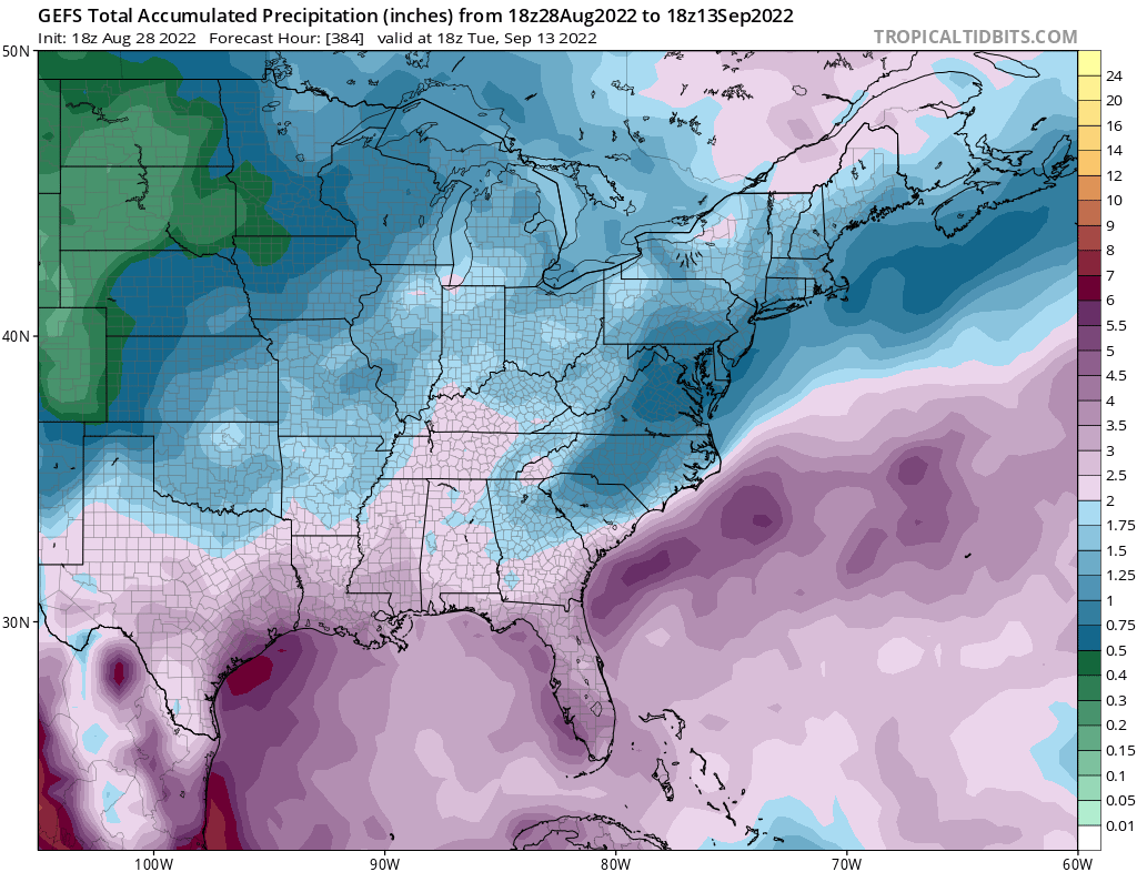
The 18z GEFS:
The 12z EPS:
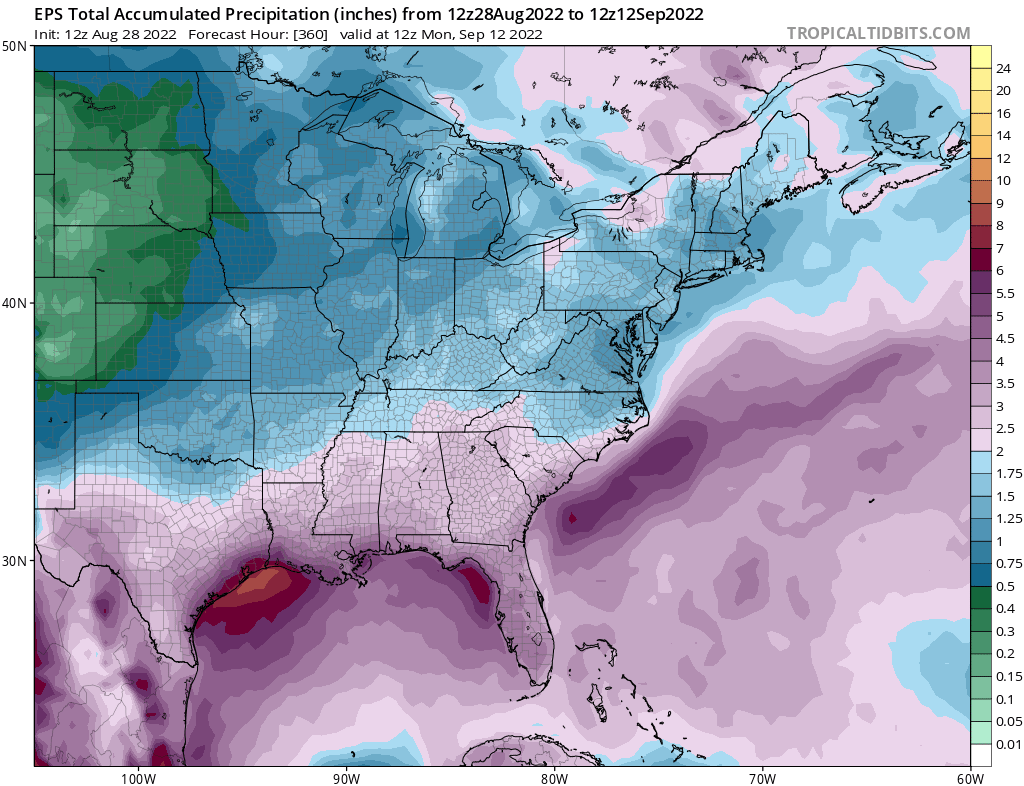
Strong agreement between both models. This is an extremely wet look for us. The wettest I can remember for the whole year so far.
The 12z EPS:
Strong agreement between both models. This is an extremely wet look for us. The wettest I can remember for the whole year so far.
-
Cromagnum
- Posts: 3065
- Joined: Thu Feb 03, 2011 10:42 pm
- Location: Georgetown
- Contact:
How much of that is occurring tomorrow? My forecast is for 1-2 inches of rain on Monday alone.
Spacecity Weather guys (rather boldy I may add) state we have nothing to worry about in Houston anytime soon.
https://spacecityweather.com/eye-on-the ... t-for-now/
Spacecity Weather guys (rather boldy I may add) state we have nothing to worry about in Houston anytime soon.
https://spacecityweather.com/eye-on-the ... t-for-now/
-
Cpv17
- Posts: 7080
- Joined: Fri Aug 31, 2018 1:58 pm
- Location: El Campo/Wharton
- Contact:
0z HRRR through 48 hours:Cromagnum wrote: ↑Sun Aug 28, 2022 9:18 pm How much of that is occurring tomorrow? My forecast is for 1-2 inches of rain on Monday alone.
Spacecity Weather guys (rather boldy I may add) state we have nothing to worry about in Houston anytime soon.
https://spacecityweather.com/eye-on-the ... t-for-now/
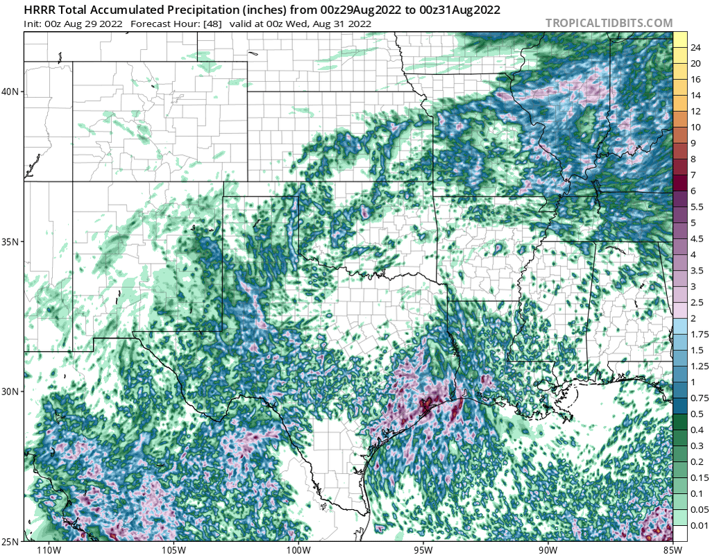
Could only get a quarter inch or get a flood.
-
Stratton20
- Posts: 5806
- Joined: Tue Feb 09, 2021 11:35 pm
- Location: College Station, Texas
- Contact:
Hrrr has some pockets of 6-8 inch totals over the next 2 days, gotta watch these mesocale models, may have some localized flooding issues
-
Cpv17
- Posts: 7080
- Joined: Fri Aug 31, 2018 1:58 pm
- Location: El Campo/Wharton
- Contact:
Yeah and the 18z HRRR had pockets of 10-12”.Stratton20 wrote: ↑Sun Aug 28, 2022 9:40 pm Hrrr has some pockets of 6-8 inch totals over the next 2 days, gotta watch these mesocale models, may have some localized flooding issues
-
Pas_Bon
- Posts: 945
- Joined: Tue Sep 11, 2018 7:58 am
- Location: League City, TX
- Contact:
Methinks we’re going to have a gully washer on our hands. Yikes. We need it, so I won’t complain.
-
DoctorMu

- Posts: 7993
- Joined: Sun Jun 28, 2015 11:58 am
- Location: College Station
- Contact:
So, yes, the old front is returning for an encore. (not all the crap that's been progged by GFS) 
Area Forecast Discussion
National Weather Service Houston/Galveston TX
1159 PM CDT Sun Aug 28 2022
...New AVIATION...
.SHORT TERM...
(Through Monday Night)
Issued at 315 PM CDT Sun Aug 28 2022
The weather this afternoon is featuring classic August conditions.
Temperatures are generally in the low to mid 90s. Dew points are in
the 70s making it feel quite humid. In addition, spotty showers and
thunderstorms are evident on radar. Some communities will be lucky
enough to receive a brief cooling shower or thunderstorm. Mid level
dry air has been limiting convection this afternoon. So thunderstorm
activity isn`t expected to be widespread. Loss of daytime heating
will decrease PoPs by the evening.
A mid/upper level disturbance in the western Gulf is moving towards
the Texas Coast. The system will enhance both PWAT and lift
tomorrow. Near the coast, showers and an isolated thunderstorm are
possible as early as late tonight. Showers and thunderstorms are
possible as far north of I-10 by mid morning tomorrow. Once we
combine daytime heating into our mix of increasing PWATs and lift,
the chance of scattered thunderstorms will increase across the
entire CWA. CAMs models continue to suggest locally heavier
thunderstorms capable of a quick 2 to 4+ inches. Considering the
likely high PWAT values, these locally heavier totals do not seem
like a stretch. Therefore, localized flooding will be a concern. At
least the increase in clouds and rainfall will keep temperatures
slightly below normal tomorrow afternoon. Highs are expected to be
in the upper 80s south of I-10. Low 90s are expected farther north.
A few locations near the immediate coast may only reach the mid 80s.
Self
&&
.LONG TERM...
(Tuesday through Sunday)
Issued at 315 PM CDT Sun Aug 28 2022
The bottom line for the Long Term will be periods of showers and
thunderstorms. System in the western Gulf waters this weekend
(or what`s left of the system and its associated deep moisture
axis) will edge westward toward our area and help to support shower
and thunderstorm development almost every day. Assisting in this
development could be a weak front that will be sagging into the
area from the north and will possibly stall in the Thursday-Friday
time period. Slightly drier air to the north of this boundary might
infiltrate parts of our area resulting in lower rain chances/coverage.
Bottom line for the week is that some days will likely end up wetter
and some days will likely end up drier, and the better chances and
better coverage might hold off until the weekend for areas near the
coast and especially offshore when a deeper plume of moisture edges
into the area from the Gulf.
-
DoctorMu
- Posts: 7993
- Joined: Sun Jun 28, 2015 11:58 am
- Location: College Station
- Contact:
Peso peeks:


-
Andrew
- Site Admin

- Posts: 3508
- Joined: Wed Feb 03, 2010 9:46 pm
- Location: North-West Houston
- Contact:
Looks like the surge of tropical moisture from the south and a weak surface trough trying to develop along the coast will provide plenty of rain chances through the first half of the week. Some localized flooding concerns are possible too as rain rates look to be pretty heavy in some of the stronger cells and some training is possible. Looking further ahead the 00Z GFS has stopped the vort max from detaching from the monsoonal trough across the Southern Caribbean and lifting north. This falls in line with the other models and severely limits tropical development. With that said, a system is still possible within the BOC but as of now it looks like any impacts will remain well south.
For Your Infinite Source For All Things Weather Visit Our Facebook
-
weatherguy425
- Pro Met

- Posts: 830
- Joined: Wed Feb 03, 2010 7:45 pm
- Location: Atlanta, Georgia
- Contact:
Something to casually watch this workweek -
Some models (various NAM runs I know, ICON, etc.) have been vaguely hinting at an area of low pressure spinning up in the northeast Gulf and detaching from a stalling front along the Gulf Coast within the next five days. Worth a very casual watch to see if model support increases.
Some models (various NAM runs