
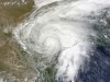
Extratropical Depression Lee: Inland N Gulf States
-
South_Texas_Storms
- Pro Met

- Posts: 55
- Joined: Fri Sep 02, 2011 1:23 pm
- Location: Houston, TX
- Contact:
Howdy yall! Been lurking for a few days (back when it was looking good for rain here).  I'm about as depressed as everyone else as I was really thinking that this could put a huge dent in our drought. Maybe we will get some rainbands tomorrow too?
-
srainhoutx

- Site Admin

- Posts: 19616
- Joined: Tue Feb 02, 2010 2:32 pm
- Location: Maggie Valley, NC
- Contact:
3rd and final vortex message from midday mission...new aircraft inbound to sample...
Product: Air Force Vortex Message (URNT12 KNHC)
Transmitted: 2nd day of the month at 18:02Z
Aircraft: Air Force Aircraft (Last 3 digits of the tail number are 306)
Tropical Depression: Number 13 (flight in the North Atlantic basin)
Mission Number: 2
Observation Number: 15
A. Time of Center Fix: 2nd day of the month at 17:27:00Z
B. Center Fix Coordinates: 27°17'N 91°35'W (27.2833N 91.5833W) (View map)
B. Center Fix Location: 205 miles (329 km) to the S (172°) from Lafayette, LA, USA.
C. Minimum Height at Standard Level: 1,461m (4,793ft) at 850mb
D. Estimated (by SFMR or visually) Maximum Surface Wind: 16kts (~ 18.4mph)
E. Location of the Estimated Maximum Surface Wind: 28 nautical miles (32 statute miles) to the S (170°) of center fix
F. Maximum Flight Level Wind Inbound: From 223° at 15kts (From the SW at ~ 17.3mph)
G. Location of Maximum Flight Level Wind Inbound: 28 nautical miles (32 statute miles) to the S (170°) of center fix
H. Minimum Sea Level Pressure: 1003mb (29.62 inHg)
I. Maximum Flight Level Temp & Pressure Altitude Outside Eye: 19°C (66°F) at a pressure alt. of 1,522m (4,993ft)
J. Maximum Flight Level Temp & Pressure Altitude Inside Eye: 20°C (68°F) at a pressure alt. of 1,525m (5,003ft)
K. Dewpoint Temp (collected at same location as temp inside eye): 11°C (52°F)
K. Sea Surface Temp (collected at same location as temp inside eye): Not Available
L. Eye Character: Not Available
M. Eye Shape: Not Available
N. Fix Determined By: Penetration, Radar, Wind, Pressure and Temperature
N. Fix Level: 850mb
O. Navigation Fix Accuracy: 0.02 nautical miles
O. Meteorological Accuracy: 4 nautical miles
Remarks Section:
Maximum Flight Level Wind: 36kts (~ 41.4mph) in the east quadrant at 16:11:30Z
Carla/Alicia/Jerry(In The Eye)/Michelle/Charley/Ivan/Dennis/Katrina/Rita/Wilma/Humberto/Ike/Harvey
Member: National Weather Association
Facebook.com/Weather Infinity
Twitter @WeatherInfinity
Member: National Weather Association
Facebook.com/Weather Infinity
Twitter @WeatherInfinity

I still think there may be a chance that the models are wrong and Lee will be shunted off to the SW after spending all that time along the Northern Gulf Coast. It's a wait and see type deal. I'm still not buying this NE push.srainhoutx wrote:The 12Z Euro suggests Lee will meander S of Lafayette/Vermillion Bay while slowly strengthening and finally head inland near hour 120, for what it's worth.
~~~When Thunder Roars Go Indoors~~~
~~~Turn Around Don't Drown~~~
~~~Run From The Water, Hide From The Wind~~~
~~~Turn Around Don't Drown~~~
~~~Run From The Water, Hide From The Wind~~~

Just give up now and cut your losses. The pain won't be as bad, even thought it's already about as tough as it gets.djjordan wrote:I still think there may be a chance that the models are wrong and Lee will be shunted off to the SW after spending all that time along the Northern Gulf Coast. It's a wait and see type deal. I'm still not buying this NE push.srainhoutx wrote:The 12Z Euro suggests Lee will meander S of Lafayette/Vermillion Bay while slowly strengthening and finally head inland near hour 120, for what it's worth.
LOLjasons wrote:Just give up now and cut your losses. The pain won't be as bad, even thought it's already about as tough as it gets.djjordan wrote:I still think there may be a chance that the models are wrong and Lee will be shunted off to the SW after spending all that time along the Northern Gulf Coast. It's a wait and see type deal. I'm still not buying this NE push.srainhoutx wrote:The 12Z Euro suggests Lee will meander S of Lafayette/Vermillion Bay while slowly strengthening and finally head inland near hour 120, for what it's worth.
~~~When Thunder Roars Go Indoors~~~
~~~Turn Around Don't Drown~~~
~~~Run From The Water, Hide From The Wind~~~
~~~Turn Around Don't Drown~~~
~~~Run From The Water, Hide From The Wind~~~

NWS for Beaumont has Mondays low of 54 and Tuesday's high of 77!! Wow! Is this front really going to be that strong? Brrr...
Mike
Beaumont, TX
(IH-10 & College Street)
Beaumont, TX
(IH-10 & College Street)
-
maroondreams
- Posts: 14
- Joined: Thu Feb 03, 2011 8:06 pm
- Location: Houston, Tx (77040)
- Contact:
I'm telling you we all need to go wash our cars. It never fails but to rain every time to wash mine. If we ALL do it then maybe just maybe a few sprinkles will come down from the heavens.djjordan wrote:LOL maybe we should all do a flash mob rain dance down at discovery green park Maybe that'll get Lee's attention
It kills me that this is happening. All those trees in memorial and our historic areas (not to mention the new trees) that are dying. Ugh, I personally already think this town doesn't have enough and to loose what we have. Just heartbreaking to say the least.
I agree it is so depressing driving to work looking at all of the dead trees. I am just plain depressed at how many times it looks like rain is coming then nothing. What is it going to take to break this ridge?
-
srainhoutx
- Site Admin
- Posts: 19616
- Joined: Tue Feb 02, 2010 2:32 pm
- Location: Maggie Valley, NC
- Contact:
Our 'cool front' should break the ridge. What we'll need to watch is when that boundary retreats/washes out and all that moisture in Caribbean begins to return.Karen wrote:I agree it is so depressing driving to work looking at all of the dead trees. I am just plain depressed at how many times it looks like rain is coming then nothing. What is it going to take to break this ridge?
Carla/Alicia/Jerry(In The Eye)/Michelle/Charley/Ivan/Dennis/Katrina/Rita/Wilma/Humberto/Ike/Harvey
Member: National Weather Association
Facebook.com/Weather Infinity
Twitter @WeatherInfinity
Member: National Weather Association
Facebook.com/Weather Infinity
Twitter @WeatherInfinity
I hope you are right on that cooler weather will be nice change.
-
South_Texas_Storms
- Pro Met
- Posts: 55
- Joined: Fri Sep 02, 2011 1:23 pm
- Location: Houston, TX
- Contact:
I just don't see any relief for at least the next 10 days. The GFS is showing pretty much no rain for all of Texas for the next 16 days.srainhoutx wrote:Our 'cool front' should break the ridge. What we'll need to watch is when that boundary retreats/washes out and all that moisture in Caribbean begins to return.Karen wrote:I agree it is so depressing driving to work looking at all of the dead trees. I am just plain depressed at how many times it looks like rain is coming then nothing. What is it going to take to break this ridge?
-
srainhoutx
- Site Admin
- Posts: 19616
- Joined: Tue Feb 02, 2010 2:32 pm
- Location: Maggie Valley, NC
- Contact:
We'll spend more time on long range solutions once we get beyond the Lee threat. Check out the September Topic and hopefully we can get some others to chime in with their thoughts as well. With that said, the frontal boundary is stalled from the Western Great Lakes back through Eastern Colorado and on W into Utah. There is a kicker trough/boundary dropping SE from NW Canada. That may be the focal point to energize the stalled boundary to our N along with a 'tug' from the subsidence or sinking air on the left flank of our developing cyclone to our E. More later. Let's see how much progress these systems make and what the synoptic setup is once Lee exits stage right.South_Texas_Storms wrote:I just don't see any relief for at least the next 10 days. The GFS is showing pretty much no rain for all of Texas for the next 16 days.srainhoutx wrote:Our 'cool front' should break the ridge. What we'll need to watch is when that boundary retreats/washes out and all that moisture in Caribbean begins to return.Karen wrote:I agree it is so depressing driving to work looking at all of the dead trees. I am just plain depressed at how many times it looks like rain is coming then nothing. What is it going to take to break this ridge?
Carla/Alicia/Jerry(In The Eye)/Michelle/Charley/Ivan/Dennis/Katrina/Rita/Wilma/Humberto/Ike/Harvey
Member: National Weather Association
Facebook.com/Weather Infinity
Twitter @WeatherInfinity
Member: National Weather Association
Facebook.com/Weather Infinity
Twitter @WeatherInfinity
All I can say is  A drop or two of moisture would be nice. Such a tease, Don to the West, Lee to the East. Something just does not want to give us any considerable rain fall.

Lee continues to fight the upper level low centered over the Port Arthur area with all of the convection off on the east side. Even though the atmosphere continues to slowly moisten over the region, subsidence from Lee along with subsidence on the western side of the upper low are not allowing much shower development at this time. With that upper low slowly moving off to the west-southwest over the next day or so, it will continue to block the westward extent to Lee's movement and could eventually help turn the cyclone off to the north towards the central Louisiana coast. Also, unfortunately the trough currently located across the northern Rockies looks to be somewhat stronger than what the models have been indicating. This means that there is better support for a turn more to the northeast late in the weekended as it deepens over the eastern US. Our only hope for some showers will be tomorrow as Lee approaches the coast and maybe can expand in size some during the afternoon.
yea it really doesn't look promising at all.
We can't catch a break.
It doesn't rain here anymore.
End of story.
We can't catch a break.
It doesn't rain here anymore.
End of story.


Going back to 1870, there were 5 October storms in Texas. So you do the math, it should happen every 28 years on average. So, I think we could see one this year.jasons wrote:
It's the beginning of the end. Once the fronts start, it becomes much more difficult for a storm to penetrate the TX coast. Our season is virtually over on Oct 1st. Jerry was probably as once-in-a-lifetime storm.
Getting sick of this drought too. I want rain.
The Rain Maker: Laser May Create Raindrops
http://abcnews.go.com/blogs/technology/ ... raindrops/
-
srainhoutx
- Site Admin
- Posts: 19616
- Joined: Tue Feb 02, 2010 2:32 pm
- Location: Maggie Valley, NC
- Contact:
BULLETIN
TROPICAL STORM LEE ADVISORY NUMBER 5
NWS NATIONAL HURRICANE CENTER MIAMI FL AL132011
400 PM CDT FRI SEP 02 2011
...TROPICAL STORM LEE DRIFTING NORTHWARD TOWARD THE SOUTHERN
LOUISIANA COAST...SQUALLS WITH HEAVY RAIN AND GUSTY WINDS SPREADING
INLAND ACROSS MUCH OF SOUTHEASTERN AND SOUTH-CENTRAL LOUISIANA...
SUMMARY OF 400 PM CDT...2100 UTC...INFORMATION
----------------------------------------------
LOCATION...27.5N 91.5W
ABOUT 185 MI...295 KM SW OF THE MOUTH OF THE MISSISSIPPI RIVER
ABOUT 220 MI...355 KM SE OF PORT ARTHUR TEXAS
MAXIMUM SUSTAINED WINDS...45 MPH...75 KM/H
PRESENT MOVEMENT...N OR 355 DEGREES AT 2 MPH...4 KM/H
MINIMUM CENTRAL PRESSURE...1003 MB...29.62 INCHES
WATCHES AND WARNINGS
--------------------
CHANGES WITH THIS ADVISORY...
NONE
SUMMARY OF WATCHES AND WARNINGS IN EFFECT...
A TROPICAL STORM WARNING IS IN EFFECT FOR...
* PASCAGOULA MISSISSIPPI WESTWARD TO SABINE PASS TEXAS...INCLUDING
THE CITY OF NEW ORLEANS...LAKE PONTCHARTRAIN...AND LAKE MAUREPAS
A TROPICAL STORM WARNING MEANS THAT TROPICAL STORM CONDITIONS ARE
EXPECTED SOMEWHERE WITHIN THE WARNING AREA...IN THIS CASE WITHIN THE
NEXT 24 HOURS.
FOR STORM INFORMATION SPECIFIC TO YOUR AREA...INCLUDING POSSIBLE
INLAND WATCHES AND WARNINGS...PLEASE MONITOR PRODUCTS ISSUED BY
YOUR LOCAL NATIONAL WEATHER SERVICE FORECAST OFFICE.
DISCUSSION AND 48-HOUR OUTLOOK
------------------------------
AT 400 PM CDT...2100 UTC...THE CENTER OF TROPICAL STORM LEE WAS
LOCATED NEAR LATITUDE 27.5 NORTH...LONGITUDE 91.5 WEST. LEE IS
DRIFTING TOWARD THE NORTH NEAR 2 MPH...4 KM/H. A SLOW AND
POSSIBLY ERRATIC MOTION TOWARD THE NORTHWEST OR NORTH IS EXPECTED
TONIGHT AND SATURDAY. ON THE FORECAST TRACK...THE CENTER OF THE
TROPICAL STORM IS EXPECTED TO APPROACH THE COAST OF SOUTHERN
LOUISIANA DURING THE WEEKEND.
REPORTS FROM OIL RIGS AND AN AIR FORCE RESERVE UNIT RECONNAISSANCE
AIRCRAFT INDICATE MAXIMUM SUSTAINED WINDS HAVE INCREASED TO NEAR 45
MPH...75 KM/H...WITH HIGHER GUSTS. GRADUAL STRENGTHENING IS
FORECAST DURING THE NEXT 48 HOURS.
TROPICAL-STORM-FORCE WINDS EXTEND OUTWARD UP TO 200 MILES...325
KM...MAINLY NORTHEAST THROUGH SOUTHEAST OF THE CENTER. A SUSTAINED
WIND OF 60 MPH WAS RECENTLY OBSERVED ON AN OIL RIG LOCATED ABOUT 65
MILES SOUTH OF THE MOUTH OF MISSISSIPPI RIVER AT AN ALTITUDE A FEW
HUNDRED FEET ABOVE THE OCEAN SURFACE.
THE ESTIMATED MINIMUM CENTRAL PRESSURE BASED ON REPORTS FROM NEARBY
OIL RIGS IS 1003 MB...29.62 INCHES.
HAZARDS AFFECTING LAND
----------------------
RAINFALL...TROPICAL STORM LEE IS EXPECTED TO PRODUCE TOTAL RAIN
ACCUMULATIONS OF 10 TO 15 INCHES OVER SOUTHERN LOUISIANA...SOUTHERN
MISSISSIPPI...AND SOUTHERN ALABAMA THROUGH SUNDAY...WITH POSSIBLE
ISOLATED MAXIMUM AMOUNTS OF 20 INCHES. THESE RAINS ARE EXPECTED TO
CAUSE EXTENSIVE FLOODING...ESPECIALLY IN URBAN AREAS. RAINFALL
AMOUNTS OF 4 TO 8 INCHES WILL BE POSSIBLE OVER THE FLORIDA
PANHANDLE THROUGH SUNDAY.
STORM SURGE...A STORM SURGE WILL RAISE WATER LEVELS BY AS MUCH AS
2 TO 4 FEET ABOVE GROUND LEVEL ALONG THE NORTHERN GULF COAST WITHIN
THE TROPICAL STORM WARNING AREA. ELEVATED WATER LEVELS ARE ALSO
POSSIBLE EAST OF THE WARNING AREA OVER COASTAL PORTIONS OF ALABAMA
AND THE FLORIDA PANHANDLE RESULTING IN MINOR COASTAL FLOODING
WITHIN THESE AREAS. SEE PRODUCTS ISSUED BY LOCAL NATIONAL WEATHER
SERVICE FORECAST OFFICES FOR MORE DETAILS.
WIND...TROPICAL STORM CONDITIONS ARE EXPECTED TO FIRST REACH THE
COAST WITHIN THE WARNING AREA THIS EVENING...MAKING OUTSIDE
PREPARATIONS DIFFICULT OR DANGEROUS.
TORNADOES...ISOLATED TORNADOES ARE POSSIBLE TONIGHT OVER PORTIONS OF
SOUTHERN LOUISIANA AND EXTREME SOUTHERN MISSISSIPPI.
NEXT ADVISORY
-------------
NEXT INTERMEDIATE ADVISORY...700 PM CDT.
NEXT COMPLETE ADVISORY...1000 PM CDT.
$$
FORECASTER STEWART
Carla/Alicia/Jerry(In The Eye)/Michelle/Charley/Ivan/Dennis/Katrina/Rita/Wilma/Humberto/Ike/Harvey
Member: National Weather Association
Facebook.com/Weather Infinity
Twitter @WeatherInfinity
Member: National Weather Association
Facebook.com/Weather Infinity
Twitter @WeatherInfinity

Can't they humor us just once and take "Louisiana" out of the discussion and replace it with "Texas"? 
We don't need a tropical system to end a drought. Many droughts ended from convective events or slow moving cold fronts.srainhoutx wrote:
Our 'cool front' should break the ridge. What we'll need to watch is when that boundary retreats/washes out and all that moisture in Caribbean begins to return.
A blizzard will end the drought I'm calling it! 