
June Ends - Hottest on Record


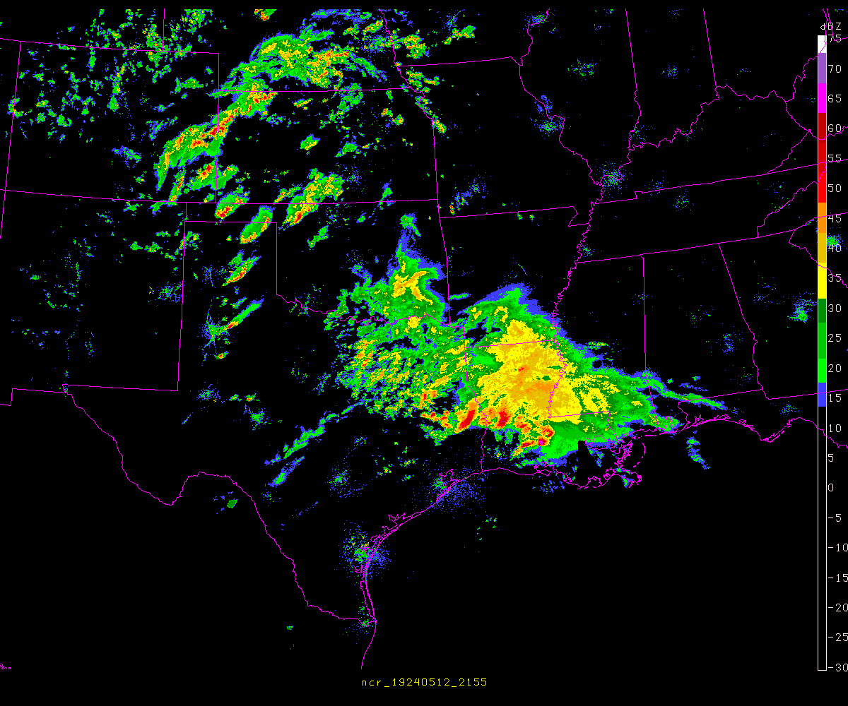
The outflow from that complex to the northeast is racing to the south. I can't get my hopes up just yet, but maybe it can hold together for at least a while longer.

I've got a cup of coffee and a bag of popcorn, mesmerized at the radar screen, Jason. Just wishin' that the complexes to the NE and NW would merge over us and dump a foot.jasons wrote:The outflow from that complex to the northeast is racing to the south. I can't get my hopes up just yet, but maybe it can hold together for at least a while longer.
-
srainhoutx

- Site Admin

- Posts: 19616
- Joined: Tue Feb 02, 2010 2:32 pm
- Location: Maggie Valley, NC
- Contact:
MESOSCALE DISCUSSION 1350
NWS STORM PREDICTION CENTER NORMAN OK
0759 PM CDT TUE JUN 21 2011
AREAS AFFECTED...PORTIONS OF WRN/NRN/CNTRL TX
CONCERNING...SEVERE THUNDERSTORM WATCH 534...
VALID 220059Z - 220200Z
THE SEVERE WEATHER THREAT FOR SEVERE THUNDERSTORM WATCH 534
CONTINUES.
WW 534 MAY NEED TO BE EXTENDED SOON ACROSS PORTIONS OF N-CNTRL TX.
WEST-EAST ORIENTED BAND OF STRONG TO SEVERE TSTMS WAS CENTERED FROM
REAGAN TO MILLS COUNTIES AS OF 0055Z. IT APPEARS LIKELY THAT FURTHER
STRENGTHENING OF THE SURFACE COLD POOL SHOULD RESULT IN SEWD
ACCELERATION OF THIS BAND TOWARDS THE HILL COUNTRY DURING THE NEXT
2-3 HOURS WITH OVERALL TRANSITION FROM LARGE HAIL TO A SEVERE WIND
THREAT.
FARTHER W/SW...DESPITE PERSISTENT TCU...CB/S HAVE BEEN RELEGATED
ALONG THE HIGHER TERRAIN IN BREWSTER COUNTY. MODEST STRENGTHENING OF
LOW-LEVEL SELYS MAY YET PROVIDE FOR ADDITIONAL TSTM DEVELOPMENT IN
THIS PORTION OF THE WW DURING THE NEXT 1-2 HOURS.
FARTHER N...A SMALL E/NEWD MOVING TSTM CLUSTER PERSISTS NEAR MWL AS
A RESULT OF EARLIER SPLITTING CELLS FAVORED BY THE UNIDIRECTIONAL
WLY WIND PROFILE ABOVE 2 KM IN THE 00Z FWD RAOB. THIS ACTIVITY
SHOULD CONTINUE TO APPROACH THE METROPLEX AND MAY EVOLVE MORE NEWD
ALONG QUASI-STATIONARY FRONT THAT ARCS TO AROUND 10 SE GYI...BASED
ON CU FIELD PRESENTATION PRIOR TO OVERSPREADING CI CANOPY.
..GRAMS.. 06/22/2011
ATTN...WFO...FWD...EWX...SJT...MAF...
- Attachments
-
Carla/Alicia/Jerry(In The Eye)/Michelle/Charley/Ivan/Dennis/Katrina/Rita/Wilma/Humberto/Ike/Harvey
Member: National Weather Association
Facebook.com/Weather Infinity
Twitter @WeatherInfinity
Member: National Weather Association
Facebook.com/Weather Infinity
Twitter @WeatherInfinity
-
srainhoutx
- Site Admin
- Posts: 19616
- Joined: Tue Feb 02, 2010 2:32 pm
- Location: Maggie Valley, NC
- Contact:
An earlier Meso Discussion for E TX...
MESOSCALE DISCUSSION 1348
NWS STORM PREDICTION CENTER NORMAN OK
0659 PM CDT TUE JUN 21 2011
AREAS AFFECTED...SERN TX...FAR WRN LA
CONCERNING...SEVERE THUNDERSTORM WATCH 534...
VALID 212359Z - 220100Z
THE SEVERE WEATHER THREAT FOR SEVERE THUNDERSTORM WATCH 534
CONTINUES.
SWD-MOVING TSTM CLUSTER ACROSS ERN TX WILL LIKELY SHIFT INTO SERN
TX/FAR WRN LA WITH ATTENDANT THREAT FOR WET MICROBURSTS AND
MARGINALLY SEVERE HAIL. A DOWNSTREAM SEVERE TSTM WATCH IS BEING
CONSIDERED.
MOST INTENSE MID-LEVEL REFLECTIVITY EXISTS ACROSS SAN AUGUSTINE
COUNTY AS OF 2350Z WITHIN BROADER SWD-MOVING TSTM COMPLEX ACROSS ERN
TX. CONTINUAL REDEVELOPMENT HAS BEEN OBSERVED ALONG THE WRN PORTION
OF ASSOCIATED OUTFLOW BOUNDARY...AIDING IN PERSISTENT AMALGAMATION
OF CELLS. DOWNSTREAM AIR MASS REMAINS VERY UNSTABLE WITH MLCAPE OF
2500 TO 3500 J/KG. HOWEVER...DEEP-LAYER SHEAR WEAKENS WITH SRN
EXTENT AND IS NOT EXPECTED TO STRENGTHEN. BUT GIVEN 30-35 KT WLYS
SAMPLED AT 6-8 KM AGL IN PALESTINE TX PROFILER...ORGANIZED
MULTICELLULAR STRUCTURES SHOULD PERSIST INTO PARTS OF SERN TX AND
PERHAPS FAR WRN LA FOR THE NEXT FEW HOURS.
..GRAMS.. 06/21/2011
ATTN...WFO...LCH...SHV...HGX...FWD...
- Attachments
-
Carla/Alicia/Jerry(In The Eye)/Michelle/Charley/Ivan/Dennis/Katrina/Rita/Wilma/Humberto/Ike/Harvey
Member: National Weather Association
Facebook.com/Weather Infinity
Twitter @WeatherInfinity
Member: National Weather Association
Facebook.com/Weather Infinity
Twitter @WeatherInfinity
-
srainhoutx
- Site Admin
- Posts: 19616
- Joined: Tue Feb 02, 2010 2:32 pm
- Location: Maggie Valley, NC
- Contact:
In other news, Harris County has banned the sell of ALL fireworks to the general public. No fireworks stands this year, folks...
COMMISSIONERS COURT BANS FIREWORKS IN RESPONSE TO HISTORIC DROUGHT CONDITIONS
Judge Emmett Signs Disaster Order Restricting Sale Or Use
Of All Fireworks Throughout Unincorporated Harris County
(Harris Co., TX) -- Harris County Judge Ed Emmett signed an order this morning declaring a drought disaster and banning the sale or use of any fireworks anywhere in unincorporated Harris County. Commissioners Court unanimously ratified Emmett’s order moments later, extending its provisions and sending it on to Gov. Rick Perry. With Perry’s approval, the disaster order remains in effect until rescinded by Emmett.
Because all 34 municipalities in Harris County already have permanent bans on the sale or use of fireworks within their jurisdictions, the action by Harris County means fireworks are illegal to sell or use throughout the entire county. In addition, most neighboring counties and municipalities have banned or are considering banning fireworks. The only exception to the ban is for a public display “conducted by a person holding a valid pyrotechnic operator’s license or a valid pyrotechnics special effects operator’s license.”
“All of us on Commissioners Court recognize public safety as our top responsibility,” Emmett said Tuesday. “I think everyone, from Fire Marshal Mike Montgomery and local fire officials to representatives of the fireworks industry and the general public at large, understands the overwhelming need to take serious preventive action to avert disastrous wildfires from threatening our property, our homes and our families.”
Harris County is experiencing unprecedented drought conditions this year, with measurements on the Keetch-Byram Drought Index (KBDI) approaching 750. The KBDI, which ranges from 0 to 800, is a measure of soil moisture and an indicator of fire potential. Commissioners Court implemented a burn ban until July 19 for unincorporated Harris County earlier this year when the KBDI reached 500. Court members extended that ban for 90 days this morning, keeping the county under a full burn ban until mid-October.
Violators of the fireworks ban face a $1,000 fine and/or 180 days in jail. Violators of the burn ban face a fine of up to $500 for each violation.
Carla/Alicia/Jerry(In The Eye)/Michelle/Charley/Ivan/Dennis/Katrina/Rita/Wilma/Humberto/Ike/Harvey
Member: National Weather Association
Facebook.com/Weather Infinity
Twitter @WeatherInfinity
Member: National Weather Association
Facebook.com/Weather Infinity
Twitter @WeatherInfinity
hoping chambers county does the same thing....and all the other surronding counties.
I agree with you all on the ban of fireworks. All counties need to do it and make sure they enforce fines for those who do not listen.
My name is Nicole and I love weather!!
~~~~~~~~~~~~~~~~~~~~~~~~~~~~~~~~~~~~~~~~~~~~~~~~~~~~~~~~~~~~~~~~~~~~~~~~~~~~~~~~~~~~~~~~~~~~~~~~
Alicia, Allison, Rita, Ike
~~~~~~~~~~~~~~~~~~~~~~~~~~~~~~~~~~~~~~~~~~~~~~~~~~~~~~~~~~~~~~~~~~~~~~~~~~~~~~~~~~~~~~~~~~~~~~~~
Alicia, Allison, Rita, Ike
-
srainhoutx
- Site Admin
- Posts: 19616
- Joined: Tue Feb 02, 2010 2:32 pm
- Location: Maggie Valley, NC
- Contact:
Very difficult forecast. Sort of a darned if you do, darned if you don't, so to speak... 
AREA FORECAST DISCUSSION
NATIONAL WEATHER SERVICE HOUSTON/GALVESTON TX
856 PM CDT TUE JUN 21 2011
.DISCUSSION...
VERY TOUGH FORECAST THIS EVENING. SHOWERS AND THUNDERSTORMS ARE IN
PORTIONS OF SOME OF OUR NORTHERN COUNTIES (SO FAR ONLY HOUSTON...TRINITY
AND POLK) AND ARE PRODUCING SOME PRETTY HEFTY RAINS THAT ARE LIKELY
HELPING TO PUT A BIG DENT IN THE AREA FIRES. STORMS CONTINUE TO SLOWLY
FORM ALONG AN ASSOCIATED SLOW MOVING OUTFLOW BOUNDARY THAT IS DRIFTING
TO THE SOUTH THROUGH SOUTHWEST. RADAR IS BEGINNING TO SHOW A SLOW WEAKENING
TREND ON THE SOUTHERN AND EASTERN SIDE OF THE MCS (PERHAPS RELATED TO
THE LOSS OF DAYTIME HEATING)...SO NOT SURE HOW LONG EVERYTHING WILL
HOLD TOGETHER AS IT MOVES SOUTHWARD. A SECOND AREA OF STRONG/SEVERE
STORMS IS IN CENTRAL TEXAS TO THE NORTHWEST OF AUSTIN AND IS MOVING
TO THE SOUTH AND SOUTHEAST. THESE STORMS HAVE A LONG WAY TO GO BEFORE
REACHING OUR AREA. PERHAPS THE TWO COMPLEXES OR BOUNDARIES CREATED BY
THE TWO COMPLEXES COULD MERGE IN OR AROUND OUR AREA OVERNIGHT? THINK
IT IS BEST TO KEEP A CHANCE OF SHOWERS AND THUNDERSTORMS ACROSS ALL
OF SOUTHEAST TEXAS FOR TONIGHT FOR THE ACTIVITY UP NORTH AND FOR POSSIBLE
STREAMER ACTIVITY DEVELOPING OVERNIGHT NEAR/OFF THE COAST. RAIN CHANCES
AND LOCATIONS TOMORROW THROUGH THURSDAY ARE VERY HARD TO FORECAST AT
THIS TIME AS WE ARE LIKELY GOING TO BE DEALING WITH MULTIPLE HARD TO
TIME AND HARD TO PLACE MESOSCALE BOUNDARIES.
Carla/Alicia/Jerry(In The Eye)/Michelle/Charley/Ivan/Dennis/Katrina/Rita/Wilma/Humberto/Ike/Harvey
Member: National Weather Association
Facebook.com/Weather Infinity
Twitter @WeatherInfinity
Member: National Weather Association
Facebook.com/Weather Infinity
Twitter @WeatherInfinity
It never ceases to give me great confidence in our Weather Service when the word "perhaps" is used.srainhoutx wrote:Very difficult forecast. Sort of a darned if you do, darned if you don't, so to speak...
PERHAPS THE TWO COMPLEXES OR BOUNDARIES CREATED BY
THE TWO COMPLEXES COULD MERGE IN OR AROUND OUR AREA OVERNIGHT? [/i]
There are two outflow boundaries clashing now right over the DFW metroplex. Seems like they get all the fun weather these days.
-
biggerbyte
- Posts: 1142
- Joined: Thu Feb 04, 2010 12:15 am
- Location: Porter, Texas. (Montgomery County)
- Contact:
Folks, watch out to our northwest overnight. Whether the storm complex holds together to give our area rain remains a possibility. There is an outflow boundary pushing ahead of it that could form homegrown showers and thunderstorms.
Let's pray for one or both. It needs to rain around here tonight and on Wednesday. After that, we dry out some more.
BB
Let's pray for one or both. It needs to rain around here tonight and on Wednesday. After that, we dry out some more.
BB


Dallas has storms right now and they had them last night at around 3:00 AM. If these storms west and northwest of here holds up and let's hope they do, rain could be here. 

NATIONAL WEATHER SERVICE HOUSTON/GALVESTON TX
1047 PM CDT TUE JUN 21 2011
.UPDATE...
UPDATED THE FORECAST PACKAGE TO REFLECT THE POTENTIAL FOR INCREASING
RAIN CHANCES DURING THE OVERNIGHT HOURS AS THE ACTIVITY OUT WEST CONTINUES
TO RACE THIS WAY. GENERALLY WENT WITH HIGHER POPS NORTH AND LOWER POPS
SOUTH AFTER MIDNIGHT TONIGHT...AND CARRIED CHANCE POPS AREA WIDE TOMORROW.
ALSO MADE SOME UPWARD ADJUSTMENTS ON QPF.
WORD HAS IT THAT A LOT OF SOUTHEAST TEXANS WOULD NOT MIND BEING WOKEN
UP TO RAIN AND THUNDER TONIGHT. HEY MOTHER NATURE - PLEASE DON`T
DISAPPOINT US.
It's pretty obvious Mother Nature just absolutely hates us by now...
-
Andrew
- Site Admin
- Posts: 3440
- Joined: Wed Feb 03, 2010 9:46 pm
- Location: North-West Houston
- Contact:
The storms are starting to send out outflow boundaries and they seem to be racing a little to fast. I am not holding my breath but I hope I am wrong. This is a similar setup to last night but a little better atmosphere conditions so we will see if they survive.
For Your Infinite Source For All Things Weather Visit Our Facebook
I like what NWS Houston says.Mr. T wrote:NATIONAL WEATHER SERVICE HOUSTON/GALVESTON TX
1047 PM CDT TUE JUN 21 2011
.UPDATE...
UPDATED THE FORECAST PACKAGE TO REFLECT THE POTENTIAL FOR INCREASING
RAIN CHANCES DURING THE OVERNIGHT HOURS AS THE ACTIVITY OUT WEST CONTINUES
TO RACE THIS WAY. GENERALLY WENT WITH HIGHER POPS NORTH AND LOWER POPS
SOUTH AFTER MIDNIGHT TONIGHT...AND CARRIED CHANCE POPS AREA WIDE TOMORROW.
ALSO MADE SOME UPWARD ADJUSTMENTS ON QPF.
WORD HAS IT THAT A LOT OF SOUTHEAST TEXANS WOULD NOT MIND BEING WOKEN
UP TO RAIN AND THUNDER TONIGHT. HEY MOTHER NATURE - PLEASE DON`T
DISAPPOINT US.
It's pretty obvious Mother Nature just absolutely hates us by now...
Whilst everyone's asleep around here, the SPC is about to issue a severe thunderstorm watch for our area. The storms have caught up to the outflow boundaries and are beginning to bow...
http://www.spc.noaa.gov/products/md/md1353.html
http://www.spc.noaa.gov/products/md/md1353.html
-
biggerbyte
- Posts: 1142
- Joined: Thu Feb 04, 2010 12:15 am
- Location: Porter, Texas. (Montgomery County)
- Contact:
SEVERE THUNDERSTORM WATCH 537 IS IN EFFECT UNTIL 600 AM CDT FOR THE FOLLOWING LOCATIONS TX . TEXAS COUNTIES INCLUDED ARE ATASCOSA AUSTIN BANDERA BASTROP BEXAR BLANCO BRAZOS BURLESON CALDWELL COLORADO COMAL DEWITT DIMMIT FAYETTE FRIO GONZALES GRIMES GUADALUPE HAYS HOUSTON KARNES KENDALL LAVACA LA SALLE LEE LIVE OAK MADISON MCMULLEN MEDINA MONTGOMERY POLK SAN JACINTO TRAVIS TRINITY UVALDE WALKER WALLER WASHINGTON WILLIAMSON WILSON ZAVALA