January Weather Discussion: Slight Chance Severe Storms

General Weather Discussions and Analysis
User avatar
Ptarmigan
Statistical Specialist
Posts: 4011
Joined: Wed Feb 03, 2010 7:20 pm
Contact:

vbhoutex wrote:
randybpt wrote:Hey don't y'all find it odd that the Gfs is always showing some exciting weather for southeast texas 10 days out like some wicked Mad mind.is.behind all this. Hmmmmmm conspiracy maybe or just maybe oh heat .......miser himself is the culprit. I will say this STEPPING DOWN I do remember a few snow.events around feb. 3rd......hey partimigan let's see the stats.
Are you talking 1973? IIRC the dates were Feb. 9 and 16. that was after an earlier snow in January, I think the 12th. the weather we have been having is starting to remind me of winters in the 70's.
It snowed three times in 1973.
January 11
February 9-10
February 17-18

The February snow was a night time event.

The last time it snowed more than once in the same month prior to 1973 was February 1899.
February 7
February 13

They were trace snowfall at the Houston Weather Bureau Office.

Years where it snowed more than once in the same month.
1899-February
1973-February
1980-February

They all happened in February.
Last edited by Ptarmigan on Fri Jan 21, 2011 3:51 pm, edited 1 time in total.
User avatar
Ptarmigan
Statistical Specialist
Posts: 4011
Joined: Wed Feb 03, 2010 7:20 pm
Contact:

I am seeing some interesting forecast models for the next 10 to 16 days. Bring on the cold air! :twisted:
TexasMetBlake
Pro Met
Pro Met
Posts: 839
Joined: Wed Feb 03, 2010 7:03 pm
Location: Spring/Woodlands
Contact:

This, to me, appears more legit than the last scare. This time there is no mistake the cold air is there. We're talking about temps that have been consistently around -55 in Alaska and to a lesser degree the Yukon. If the H5 pattern comes to fruition, then we may be in for the grand finale. However, I caution all of you not to get excited yet. 8-10 days is a LONG ways out.
User avatar
Ptarmigan
Statistical Specialist
Posts: 4011
Joined: Wed Feb 03, 2010 7:20 pm
Contact:

wxman57 wrote:Yeah, 12Z GFS doesn't have us in the lower teens on the 2nd, but now it has us under 6" or more of snow. Doesn't look like 80 degrees that week to me, regardless.
The average date to first reach 80 at KIAH is February 6th, while median is February 8th. Last year was March 9th.
User avatar
helloitsb
Posts: 194
Joined: Mon Nov 08, 2010 7:44 pm
Location: Oklahoma, TX
Contact:

man have I missed some stuff, whats going on? I just looked on IPS which takes raw data from the GFS and it looks cold someone care to fill me in?
User avatar
cristina99
Posts: 125
Joined: Fri Jan 21, 2011 2:33 pm
Location: The Woodlands / Spring / Conroe
Contact:

You sound like the reasonable one Candy Cane. However, I don't understand all the lingo you guys use. Like I said, I am a weather novice, but I think I get the weather bug from my grandmother. How are we so sure that this next cold air will not slide east, like the one before? And where do the models show we will have snow? :D
ejburas
Posts: 68
Joined: Wed Feb 03, 2010 10:25 pm
Location: Spring, TX
Contact:

I know it's a ways out yet, but check out the forecast at myforecast.com. I believe they simply extract the data frm the GFS after each run, but it's amazing to see what it's showing. When I looked up the forecast for Cypress, it shows 4 nights below 20, with one night all the way down to 5. Just wow!
randybpt
Posts: 114
Joined: Thu Feb 04, 2010 11:20 am
Contact:

Remember guys the models were showing armgeddon around the 1st of january so its fun to look at and dream of snow but if the models keep showing this next friday then maybe. Odds are against it
sleetstorm
Posts: 651
Joined: Thu Feb 04, 2010 12:33 pm
Contact:

Start praying that this feasible weather occasion does materialize. ;)
User avatar
srainhoutx
Site Admin
Site Admin
Posts: 19616
Joined: Tue Feb 02, 2010 2:32 pm
Location: Maggie Valley, NC
Contact:

It's back via the 18Z GFS...
Carla/Alicia/Jerry(In The Eye)/Michelle/Charley/Ivan/Dennis/Katrina/Rita/Wilma/Humberto/Ike/Harvey

Member: National Weather Association
Facebook.com/Weather Infinity
Twitter @WeatherInfinity
Baseballdude2915
Posts: 192
Joined: Wed Feb 03, 2010 5:21 pm
Location: Dickinson, Tx
Contact:

Quite the model runs out there in la-la land, will be interesting if our lower teens being shown are even in lower twenties here in a few days. Ill jump on the bandwagon next Wednesday if we still have something showing up consistently.

By the way, temperatures busted around here today BIG time. Forecast for Houston was 50, when i left UH at 1:00PM it was 38 and sunny. Made it up to 42 when i got home to Dickinson. :shock:
sleetstorm
Posts: 651
Joined: Thu Feb 04, 2010 12:33 pm
Contact:

srainhoutx wrote:It's back via the 18Z GFS...
In that first model, it looks like San Antonio will or could be getting a serious snowstorm, srainhoutx.
User avatar
srainhoutx
Site Admin
Site Admin
Posts: 19616
Joined: Tue Feb 02, 2010 2:32 pm
Location: Maggie Valley, NC
Contact:

sleetstorm wrote:
srainhoutx wrote:It's back via the 18Z GFS...
In that first model, it looks like San Antonio will or could be getting a serious snowstorm, srainhoutx.
01212011 18Z GFS_3_2011012118_F240_SNOWIN_SURFACE.png
01212011 18Z GFS_3_2011012118_F252_SNOWIN_SURFACE.png
01212011 18Z GFS_3_2011012118_F264_SNOWIN_SURFACE.png
01212011 18Z GFS_3_2011012118_F276_SNOWIN_SURFACE.png
Carla/Alicia/Jerry(In The Eye)/Michelle/Charley/Ivan/Dennis/Katrina/Rita/Wilma/Humberto/Ike/Harvey

Member: National Weather Association
Facebook.com/Weather Infinity
Twitter @WeatherInfinity
User avatar
srainhoutx
Site Admin
Site Admin
Posts: 19616
Joined: Tue Feb 02, 2010 2:32 pm
Location: Maggie Valley, NC
Contact:

Look in the February thread you started... perhaps a bit of a Title edit would help...
Carla/Alicia/Jerry(In The Eye)/Michelle/Charley/Ivan/Dennis/Katrina/Rita/Wilma/Humberto/Ike/Harvey

Member: National Weather Association
Facebook.com/Weather Infinity
Twitter @WeatherInfinity
User avatar
Ptarmigan
Statistical Specialist
Posts: 4011
Joined: Wed Feb 03, 2010 7:20 pm
Contact:

Looks like we may see snow if this forecast pans out. :twisted: ;)
User avatar
srainhoutx
Site Admin
Site Admin
Posts: 19616
Joined: Tue Feb 02, 2010 2:32 pm
Location: Maggie Valley, NC
Contact:

We still have several storms/fronts to pass before we get to next weekend. Sunday may well be damp.
Carla/Alicia/Jerry(In The Eye)/Michelle/Charley/Ivan/Dennis/Katrina/Rita/Wilma/Humberto/Ike/Harvey

Member: National Weather Association
Facebook.com/Weather Infinity
Twitter @WeatherInfinity
TexasMetBlake
Pro Met
Pro Met
Posts: 839
Joined: Wed Feb 03, 2010 7:03 pm
Location: Spring/Woodlands
Contact:

HOLY...

Image

*can somebody fix the link to show the image? Cough...Steve....Cough ;)
TexasMetBlake
Pro Met
Pro Met
Posts: 839
Joined: Wed Feb 03, 2010 7:03 pm
Location: Spring/Woodlands
Contact:

It cut off the end but it showed another icing event by the 8th.
User avatar
srainhoutx
Site Admin
Site Admin
Posts: 19616
Joined: Tue Feb 02, 2010 2:32 pm
Location: Maggie Valley, NC
Contact:

I see you figured it out, Blake... ;)
Carla/Alicia/Jerry(In The Eye)/Michelle/Charley/Ivan/Dennis/Katrina/Rita/Wilma/Humberto/Ike/Harvey

Member: National Weather Association
Facebook.com/Weather Infinity
Twitter @WeatherInfinity
User avatar
wxman57
Global Moderator
Global Moderator
Posts: 2621
Joined: Thu Feb 04, 2010 5:34 am
Location: Southwest Houston (Westbury)
Contact:

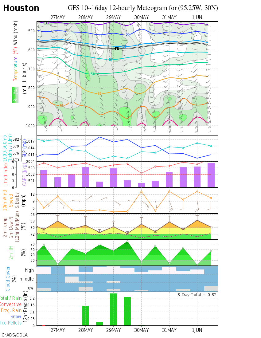
I fixed it (just highlight the URL and click the "Img" button atop the text box). But I find these meteograms easier to decipher. It shows a strong front coming through on the 31st followed by some quite cold weather and precip (snow). Note that the temperature points on the plot are at 12 hour increments - 12am and 12pm. They are NOT highs/lows for each day.
Image
Post Reply
  • Information
  • Who is online

    Users browsing this forum: Ahrefs [Bot] and 46 guests