
2011 ATL Hurricane Season: Coming to an End
-
srainhoutx

- Site Admin

- Posts: 19616
- Joined: Tue Feb 02, 2010 2:32 pm
- Location: Maggie Valley, NC
- Contact:
The latest Eurosip seasonal is out and does not bode well for a less active peak tropical months of August, September and October...
- Attachments
-
Carla/Alicia/Jerry(In The Eye)/Michelle/Charley/Ivan/Dennis/Katrina/Rita/Wilma/Humberto/Ike/Harvey
Member: National Weather Association
Facebook.com/Weather Infinity
Twitter @WeatherInfinity
Member: National Weather Association
Facebook.com/Weather Infinity
Twitter @WeatherInfinity
-
srainhoutx
- Site Admin
- Posts: 19616
- Joined: Tue Feb 02, 2010 2:32 pm
- Location: Maggie Valley, NC
- Contact:
TROPICAL WEATHER OUTLOOK
NWS NATIONAL HURRICANE CENTER MIAMI FL
200 PM EDT THU JUL 14 2011
FOR THE NORTH ATLANTIC...CARIBBEAN SEA AND THE GULF OF MEXICO...
AN AREA OF DISTURBED WEATHER HAS FORMED OVER THE SOUTHWESTERN
CARIBBEAN SEA. DEVELOPMENT...IF ANY...OF THIS SYSTEM IS EXPECTED TO
BE SLOW TO OCCUR AS IT REMAINS NEARLY STATIONARY OR DRIFTS WESTWARD
DURING THE NEXT DAY OR TWO. THIS SYSTEM HAS A LOW CHANCE...10
PERCENT...OF BECOMING A TROPICAL CYCLONE DURING THE NEXT 48 HOURS.
REGARDLESS OF DEVELOPMENT...LOCALLY HEAVY RAINFALL IS POSSIBLE OVER
PORTIONS OF CENTRAL AMERICA DURING THE NEXT FEW DAYS.
ELSEHWERE...TROPICAL CYCLONE FORMATION IS NOT EXPECTED DURING THE
NEXT 48 HOURS.
$$
FORECASTER CANGIALOSI
- Attachments
-
Carla/Alicia/Jerry(In The Eye)/Michelle/Charley/Ivan/Dennis/Katrina/Rita/Wilma/Humberto/Ike/Harvey
Member: National Weather Association
Facebook.com/Weather Infinity
Twitter @WeatherInfinity
Member: National Weather Association
Facebook.com/Weather Infinity
Twitter @WeatherInfinity
-
srainhoutx
- Site Admin
- Posts: 19616
- Joined: Tue Feb 02, 2010 2:32 pm
- Location: Maggie Valley, NC
- Contact:
CARCAH has a tentative scheduled flight to the SW Caribbean on Saturday...
WEATHER RECONNAISSANCE FLIGHTS
CARCAH, NATIONAL HURRICANE CENTER, MIAMI, FL.
1000 AM EDT THU 14 JULY 2011
SUBJECT: TROPICAL CYCLONE PLAN OF THE DAY (TCPOD)
VALID 15/1100Z TO 16/1100Z JULY 2011
TCPOD NUMBER.....11-044
I. ATLANTIC REQUIREMENTS
1. NEGATIVE RECONNAISSANCE REQUIREMENTS.
2. OUTLOOK FOR SUCCEEDING DAY: POSSIBLE LOW
LEVEL INVEST AT 16/1900Z NEAR 12N 82W.
Carla/Alicia/Jerry(In The Eye)/Michelle/Charley/Ivan/Dennis/Katrina/Rita/Wilma/Humberto/Ike/Harvey
Member: National Weather Association
Facebook.com/Weather Infinity
Twitter @WeatherInfinity
Member: National Weather Association
Facebook.com/Weather Infinity
Twitter @WeatherInfinity
-
srainhoutx
- Site Admin
- Posts: 19616
- Joined: Tue Feb 02, 2010 2:32 pm
- Location: Maggie Valley, NC
- Contact:
TROPICAL WEATHER OUTLOOK
NWS NATIONAL HURRICANE CENTER MIAMI FL
800 AM EDT FRI JUL 15 2011
FOR THE NORTH ATLANTIC...CARIBBEAN SEA AND THE GULF OF MEXICO...
AN AREA OF DISTURBED WEATHER IS MOVING INLAND OVER NICARAGUA AND
COSTA RICA...AND INTERACTION WITH LAND IS EXPECTED TO PREVENT
DEVELOPMENT OF THIS DISTURBANCE. THIS SYSTEM HAS A LOW CHANCE
...NEAR 0 PERCENT...OF BECOMING A TROPICAL CYCLONE DURING THE NEXT
48 HOURS. HOWEVER...LOCALLY HEAVY RAINFALL WILL BE POSSIBLE OVER
PORTIONS OF CENTRAL AMERICA DURING THE NEXT FEW DAYS.
ELSEWHERE...TROPICAL CYCLONE FORMATION IS NOT EXPECTED DURING THE
NEXT 48 HOURS.
$$
FORECASTER STEWART
Carla/Alicia/Jerry(In The Eye)/Michelle/Charley/Ivan/Dennis/Katrina/Rita/Wilma/Humberto/Ike/Harvey
Member: National Weather Association
Facebook.com/Weather Infinity
Twitter @WeatherInfinity
Member: National Weather Association
Facebook.com/Weather Infinity
Twitter @WeatherInfinity
-
Andrew
- Site Admin
- Posts: 3440
- Joined: Wed Feb 03, 2010 9:46 pm
- Location: North-West Houston
- Contact:
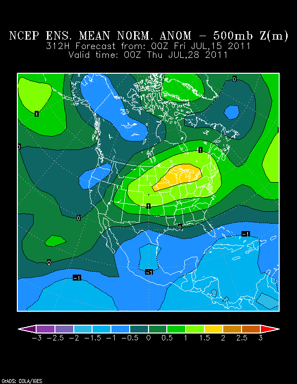
Well I think our "inactive" period (if you want to call it that) is coming to an end relatively soon. All signs are pointing towards a very active couple of months with systems beginning to erupt towards the end of July or the very beginning of August. The first signal is that the ENSO cycle looks like it is going to head neutral during the peak of the hurricane season. That could be cause for increased activity during an already active part of the season.
http://www.cpc.ncep.noaa.gov/products/a ... ts-web.pdf
Next many of the models such as the Euro and gfs are predicting a little bit of a pattern change. The seasonal Euro had sniffed this out a while back and it looks like lower then normal pressures should spread across the carribean, gulf and even parts of the South.
Many might recognize this image from the local weather thread back on the main page and this has been spread around a lot lately. If this is right it suggests some possible un-settled weather towards the gulf and Carribean. Also fortunately and unfortunately for us it could put Houston and the South in a more active pattern similar to this weekend and next week with the ridge retreating North. That could open the door up for some tropical activity to head our way if the pattern stays that way. All of the models are beginning hint at more activity and the "wave train" will begin to increase soon. Get ready everyone, be ready to loose a lot of sleep in the coming months
For Your Infinite Source For All Things Weather Visit Our Facebook


GFS is showing more unsettled weather for the Caribbean. This could mean a more active Caribbean.
Heat and maximum potential.
http://wxmaps.org/pix/hurpot.html#ATL
-
srainhoutx
- Site Admin
- Posts: 19616
- Joined: Tue Feb 02, 2010 2:32 pm
- Location: Maggie Valley, NC
- Contact:
TROPICAL WEATHER OUTLOOK
NWS NATIONAL HURRICANE CENTER MIAMI FL
200 PM EDT SAT JUL 16 2011
FOR THE NORTH ATLANTIC...CARIBBEAN SEA AND THE GULF OF MEXICO...
A SURFACE TROUGH ASSOCIATED WITH A WEAKENING FRONTAL SYSTEM IS
PRODUCING WIDESPREAD CLOUDINESS AND SHOWERS FROM THE NORTHEASTERN
FLORIDA AND GEORGIA COASTS EASTWARD OVER THE ATLANTIC OCEAN FOR
SEVERAL HUNDRED MILES. UPPER-LEVEL WINDS ARE ONLY MARGINALLY
CONDUCIVE FOR DEVELOPMENT...BUT COULD BECOME A LITTLE MORE
FAVORABLE DURING THE NEXT DAY OR TWO. THIS SYSTEM HAS A LOW
CHANCE...20 PERCENT...OF BECOMING A TROPICAL CYCLONE DURING THE
NEXT 48 HOURS AS IT MOVES SLOWLY TOWARD THE SOUTHEAST OR SOUTH.
ELSEWHERE...TROPICAL CYCLONE FORMATION IS NOT EXPECTED DURING THE
NEXT 48 HOURS.
$$
FORECASTER STEWART
- Attachments
-
Carla/Alicia/Jerry(In The Eye)/Michelle/Charley/Ivan/Dennis/Katrina/Rita/Wilma/Humberto/Ike/Harvey
Member: National Weather Association
Facebook.com/Weather Infinity
Twitter @WeatherInfinity
Member: National Weather Association
Facebook.com/Weather Infinity
Twitter @WeatherInfinity
-
srainhoutx
- Site Admin
- Posts: 19616
- Joined: Tue Feb 02, 2010 2:32 pm
- Location: Maggie Valley, NC
- Contact:
It looks like the 12Z Euro is sniffing out a possible W bound disturbance in the long range for the Gulf...
- Attachments
-
-
Carla/Alicia/Jerry(In The Eye)/Michelle/Charley/Ivan/Dennis/Katrina/Rita/Wilma/Humberto/Ike/Harvey
Member: National Weather Association
Facebook.com/Weather Infinity
Twitter @WeatherInfinity
Member: National Weather Association
Facebook.com/Weather Infinity
Twitter @WeatherInfinity
-
biggerbyte
- Posts: 1142
- Joined: Thu Feb 04, 2010 12:15 am
- Location: Porter, Texas. (Montgomery County)
- Contact:
Radars KMLB and KAMX in Florida clearly show a rotation off their east coast.
-
srainhoutx
- Site Admin
- Posts: 19616
- Joined: Tue Feb 02, 2010 2:32 pm
- Location: Maggie Valley, NC
- Contact:
The 00Z Euro and GFS are sniffing possible development near the Eastern Caribbean in 144 hours...
- Attachments
-
-
Carla/Alicia/Jerry(In The Eye)/Michelle/Charley/Ivan/Dennis/Katrina/Rita/Wilma/Humberto/Ike/Harvey
Member: National Weather Association
Facebook.com/Weather Infinity
Twitter @WeatherInfinity
Member: National Weather Association
Facebook.com/Weather Infinity
Twitter @WeatherInfinity
-
srainhoutx
- Site Admin
- Posts: 19616
- Joined: Tue Feb 02, 2010 2:32 pm
- Location: Maggie Valley, NC
- Contact:
A rather impressive CV wave near 35W is beginning to get 'that' look. We'll need to watch this feature in the days ahead as a Kelvin Wave looks to enter the Basin and a more favorable MJO pulse heads E. It's getting close to time when eyes will need to look further E in the Atlantic to those Cape Verde systems...


Carla/Alicia/Jerry(In The Eye)/Michelle/Charley/Ivan/Dennis/Katrina/Rita/Wilma/Humberto/Ike/Harvey
Member: National Weather Association
Facebook.com/Weather Infinity
Twitter @WeatherInfinity
Member: National Weather Association
Facebook.com/Weather Infinity
Twitter @WeatherInfinity
-
Andrew
- Site Admin
- Posts: 3440
- Joined: Wed Feb 03, 2010 9:46 pm
- Location: North-West Houston
- Contact:
Ed Mahmoud wrote:Somebody mentioned the lowest MDR SLP's since 2005, but didn't provide a link, and I was unsuccessful searching for any kind of anomaly SLP map for the MDR.
But, if true, with the 3rd highest June TNA (and SSTs supportive of cyclogenesis already to coastal Africa at 10º, a little earlier than usual) this is all good news for people hoping for a 1938 storm or a repeat of 2004.
2008 itself was a fun season except for September,
Your friend Jeff said that this morning in his email:
" Atlantic Sea Level Pressures have rapidly fallen to some of the lowest levels recorded in the past 50 years comparing closely to the same time in the 2005 hurricane season. The decline in SLP is concerning especially during the upcoming months of August and September and such low pressures help breed more frequent and more intense tropical cyclones. All parameters remain favorable for a significant increase in tropical cyclone activity basin wide starting in the next few weeks."
For Your Infinite Source For All Things Weather Visit Our Facebook
-
srainhoutx
- Site Admin
- Posts: 19616
- Joined: Tue Feb 02, 2010 2:32 pm
- Location: Maggie Valley, NC
- Contact:
Hmmm...
- Attachments
-
Carla/Alicia/Jerry(In The Eye)/Michelle/Charley/Ivan/Dennis/Katrina/Rita/Wilma/Humberto/Ike/Harvey
Member: National Weather Association
Facebook.com/Weather Infinity
Twitter @WeatherInfinity
Member: National Weather Association
Facebook.com/Weather Infinity
Twitter @WeatherInfinity
-
srainhoutx
- Site Admin
- Posts: 19616
- Joined: Tue Feb 02, 2010 2:32 pm
- Location: Maggie Valley, NC
- Contact:
The 12Z Canadian is sniffing development SE of the Bahamas...
- Attachments
-
Carla/Alicia/Jerry(In The Eye)/Michelle/Charley/Ivan/Dennis/Katrina/Rita/Wilma/Humberto/Ike/Harvey
Member: National Weather Association
Facebook.com/Weather Infinity
Twitter @WeatherInfinity
Member: National Weather Association
Facebook.com/Weather Infinity
Twitter @WeatherInfinity


-
srainhoutx
- Site Admin
- Posts: 19616
- Joined: Tue Feb 02, 2010 2:32 pm
- Location: Maggie Valley, NC
- Contact:
The 12Z Euro suggests a disturbance near Hispaniola...
- Attachments
-
Carla/Alicia/Jerry(In The Eye)/Michelle/Charley/Ivan/Dennis/Katrina/Rita/Wilma/Humberto/Ike/Harvey
Member: National Weather Association
Facebook.com/Weather Infinity
Twitter @WeatherInfinity
Member: National Weather Association
Facebook.com/Weather Infinity
Twitter @WeatherInfinity
-
srainhoutx
- Site Admin
- Posts: 19616
- Joined: Tue Feb 02, 2010 2:32 pm
- Location: Maggie Valley, NC
- Contact:
The Roundy TC Genesis maps suggest we may see some Gulf activity during the first couple of weeks in August...
- Attachments
-
Carla/Alicia/Jerry(In The Eye)/Michelle/Charley/Ivan/Dennis/Katrina/Rita/Wilma/Humberto/Ike/Harvey
Member: National Weather Association
Facebook.com/Weather Infinity
Twitter @WeatherInfinity
Member: National Weather Association
Facebook.com/Weather Infinity
Twitter @WeatherInfinity
-
srainhoutx
- Site Admin
- Posts: 19616
- Joined: Tue Feb 02, 2010 2:32 pm
- Location: Maggie Valley, NC
- Contact:
12Z UKMET...same general location...
Carla/Alicia/Jerry(In The Eye)/Michelle/Charley/Ivan/Dennis/Katrina/Rita/Wilma/Humberto/Ike/Harvey
Member: National Weather Association
Facebook.com/Weather Infinity
Twitter @WeatherInfinity
Member: National Weather Association
Facebook.com/Weather Infinity
Twitter @WeatherInfinity
-
srainhoutx
- Site Admin
- Posts: 19616
- Joined: Tue Feb 02, 2010 2:32 pm
- Location: Maggie Valley, NC
- Contact:
12Z Euro Ensemble Mean suggests a disturbance passing just S of Florida near day 10...
Also the HPC is depicting a disturbance in the SE/Central Bahamas on day 7...
Also the HPC is depicting a disturbance in the SE/Central Bahamas on day 7...
Carla/Alicia/Jerry(In The Eye)/Michelle/Charley/Ivan/Dennis/Katrina/Rita/Wilma/Humberto/Ike/Harvey
Member: National Weather Association
Facebook.com/Weather Infinity
Twitter @WeatherInfinity
Member: National Weather Association
Facebook.com/Weather Infinity
Twitter @WeatherInfinity
-
srainhoutx
- Site Admin
- Posts: 19616
- Joined: Tue Feb 02, 2010 2:32 pm
- Location: Maggie Valley, NC
- Contact:
T wave looking better, convectively speaking, this morning. My hunch is we'll see an INVEST before the day is out. I suspect that the NHC would like to start running the Hurricane models for what may well be a future Cindy.
Carla/Alicia/Jerry(In The Eye)/Michelle/Charley/Ivan/Dennis/Katrina/Rita/Wilma/Humberto/Ike/Harvey
Member: National Weather Association
Facebook.com/Weather Infinity
Twitter @WeatherInfinity
Member: National Weather Association
Facebook.com/Weather Infinity
Twitter @WeatherInfinity