
May 2024

Just last night they only had a 30% chance of rain for today lol
Severe watches going up out west and in the panhandle, new mesoscale discussion regarding central Texas potentially needing a watch in the next few hours. Flood watch now includes Harris Co. Things finally seem to be getting started, albeit much later than what most models hinted at for most of the day in our general neck of the woods. Not overly optimistic on any super high totals locally, but always have to watch out for training cells.
Hopefully this expands to the south. We could use a couple inches out my way.
-
Stratton20
- Posts: 4254
- Joined: Tue Feb 09, 2021 11:35 pm
- Location: College Station, Texas
- Contact:
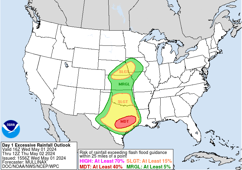
Hopefully that axis of heavy rain shifts further south, i could use a good couple of inches, when is the raib supposed to get going?

- imange1.png (340.44 KiB) Viewed 878 times
ABC13 just put out a graphic and it had almost all the rain north of I-10 through FridayStratton20 wrote: ↑Wed May 01, 2024 4:27 pm Hopefully that axis of heavy rain shifts further south, i could use a good couple of inches, when is the raib supposed to get going?
Futurecast had it pounding the area during rush hour tomorrow. Should make a fun drive to IAH in the morning, the one time in 5 years I've needed to go up there.Cpv17 wrote: ↑Wed May 01, 2024 4:58 pmABC13 just put out a graphic and it had almost all the rain north of I-10 through FridayStratton20 wrote: ↑Wed May 01, 2024 4:27 pm Hopefully that axis of heavy rain shifts further south, i could use a good couple of inches, when is the raib supposed to get going?
“It doesn’t always rain in Houston, but when it does, it does so during the morning commute.”
Looks like another storm complex overnight again like the other day.
- Screenshot 2024-05-01 at 19-16-34 Models HRRR - Pivotal Weather.png (397.95 KiB) Viewed 750 times
- Screenshot 2024-05-01 at 19-16-57 Models HRRR - Pivotal Weather.png (428.56 KiB) Viewed 750 times
- Screenshot 2024-05-01 at 19-19-42 Models HRRR - Pivotal Weather.png (435.19 KiB) Viewed 749 times


If the HRRR forecast model is any indication, it could get nasty.
If thunderstorms move faster, more likely for strong winds. Slower moving means heavy rain and possible for flooding.
https://forecast.weather.gov/product.ph ... glossary=1
https://forecast.weather.gov/product.ph ... glossary=1
Code: Select all
635
FXUS64 KHGX 020001
AFDHGX

Area Forecast Discussion
National Weather Service Houston/Galveston TX
701 PM CDT Wed May 1 2024

...New AVIATION...

.SHORT TERM...
(This evening through Thursday Night)
Issued at 333 PM CDT Wed May 1 2024

We continue to anticipate a heavy rain event overnight and into
tomorrow, which will pose a risk of flash flooding while also
exacerbating ongoing river flooding. A Flood Watch, which now
including Harris County as well as other locations along and north
of the I-10 corridor within the original Watch, will be in effect
between 10 PM tonight and 7 PM tomorrow. Additionally, this line of
storms will pose a threat of severe weather, particularly strong
wind gusts, as it moves through the area.

Models still remain in good agreement in showing the progression of
a robust midlevel trough, which will move across the area overnight
and into tomorrow. Environmental conditions remain favorable for
heavy rain, with abundant moisture availability (PWs of around 2.0
in) that will be sustained by steady onshore flow. Soils remain well-
saturated from Sunday/Monday`s storms, which, combined with elevated
river and creek levels, will make flash flooding quicker to develop.
Furthermore, SB instability in the range of 1500 J/kg and effective
layer shear of 40+kt during the overnight/early tomorrow period will
both support heavy rain and the potential for strong to severe wind
gusts. The approach of the aforementioned trough is expected to
induce the development of an MCS to our northwest, with the complex
of storms moving from NW to SE over the course of the overnight and
morning hours. A few isolated storms ahead of the line are possible,
and these storms may result in a few brief heavy downpours. However,
the main heavy rainfall window looks to remain concentrated around
the 2 AM to 12 PM timeframe.

In terms of rainfall totals, there remains quite a bit of
uncertainty across the most recent iterations of available HiRes
models as well as the HREF. Generally, the axis of heaviest rainfall
has shifted to the south since yesterday, with most locations along
and north of the I-10 corridor poised to receive average rainfall
amounts between 2-5". Some localized totals may reach 6-9", although
the exact location and extent of any higher amounts will be
dependent on exactly how the development of the line unfolds. A
faster-moving line, as depicted in some of the more recent HRRR
runs, would favor less instances of localized higher amounts but
would also result in an increased risk of strong/severe wind gusts
with the development of a stronger cold pool behind the line. With
slower-moving solutions, we`d expect to see greater instances of the
locally higher amounts. A few solutions also show some redevelopment
of scattered storms tomorrow afternoon, which could produce a few
more locally heavy downpours.

While uncertainty remains in the forecast, we nonetheless still
anticipate a widespread flooding threat with the threat of severe
weather also still present. In addition to the threat of street
flooding, these additional rains will also contribute to the ongoing
river flooding across the area, particularly across portions of the
San Jacinto and Trinity basins. This period will remain a time to be
weather aware and weather prepared...with flooding and strong winds
potentially impacting the morning commute across the area, caution
should be exercised while traveling. Having multiple ways to receive
warnings remains very important!

Cady

&&That’s some sort of storm over Trinity. Same areas that got pounded a couple days ago are getting it again. Here we are down south bone dry.
Man I feel for anyone down south of the Trinity River. That’s gonna be some catastrophic flooding downstream.
-
captainbarbossa19

- Posts: 402
- Joined: Mon Jun 28, 2021 2:50 pm
- Location: Starkville, MS
- Contact:
If you are frustrated about no rain so far, I think you will get it soon enough.

Been hearing that song for two months.captainbarbossa19 wrote: ↑Wed May 01, 2024 10:44 pm If you are frustrated about no rain so far, I think you will get it soon enough.
-
tireman4

- Global Moderator

- Posts: 4509
- Joined: Wed Feb 03, 2010 9:24 pm
- Location: Humble, Texas
- Contact:
990
FXUS64 KHGX 021201
AFDHGX
Area Forecast Discussion
National Weather Service Houston/Galveston TX
701 AM CDT Thu May 2 2024
...New AVIATION...
.SHORT TERM...
(Today through Friday Night)
Issued at 247 AM CDT Thu May 2 2024
The bulk of the widespread showers and thunderstorms tonight have re-
mained mostly north of a line from Lake Somerville to Lake Livingston.
Unfortunately, this means that a lot of the same locations that got a
bunch of rains earlier this week are getting yet another round. These
storms (the initial development here along with the western activity,
which is finally moving into the CWA), are expected to organize a bit
more before finally tracking off to the east by mid to late morning.
However, in its wake the associated frontal/outlflow/surface boundary
will be left lingering across the FA. And so, with some daytime heat-
ing, we could see more development later this afternoon. We could get
another break from the storms by this evening, but hi-res models seem
to be indicating yet another round of widespread showers and thunder-
storms for late tonight through early Fri morning. Current models are
tracking these storms more across the central and southern CWA during
this period.
So, with this in mind, have extended the Flood Watch through Fri aft-
ernoon. This watch will likely be tweaked by later shifts...mainly to
include counties south of the current watch. If all this goes accord-
ing to the plan, we may see improving conditions (that is, decreasing
POPs) by late Fri afternoon/evening. 41
&&
.LONG TERM...
(Saturday through Wednesday)
Issued at 247 AM CDT Thu May 2 2024
On Saturday afternoon, chance for showers and thunderstorms are
still on the table, mainly for the Brazos Valley and Piney Woods
region as another disturbance passes just to the north of the
region. Although there is some capping in place during the morning
hours, forecast sounding show it decreasing in the afternoon, and
with fairly good instability, we could see some isolated to
scattered activity developing over the aforementioned region. A
similar set up is progged for Sunday, with chance of showers and
thunderstorms, mainly north of I-10. We might even have the
combination of locally driven storms along with the storms
developing over Central Texas moving into our northern counties.
It is important to note that with all the expected rainfall for
today and Friday, some of these locations may have very saturated
soils along with some ongoing localized area flooding and river
flooding. Therefore, any additional heavy rainfall could result in
additional minor flooding along with further rises in creeks, small
streams, and rivers. Remember to never pass through flooded
roadways.
Things will be settling down more next week as mid to upper level
ridging begins to build over Southeast Texas. Fairly tranquil
conditions can be expected Monday into Wednesday but conditions will
be warming up each day and highs will be reaching the upper 80s to
low 90s with some locations possibly in the mid 90s by midweek. PWs
will range between 1.3 to 1.8 inches and with dewpoints mainly in
the low 70s, conditions will feel even warmer as well as muggy. In
fact, might even see heat indices in the low 100s by midweek.
24
&&
.AVIATION...
(12Z TAF Issuance)
Issued at 649 AM CDT Thu May 2 2024
Strong to severe thunderstorms will continue to move near/around
CXO, IAH, HOU within the next hour or so. Expect gusty erratic
winds and reduced visibility with this line of storms. Showers and
thunderstorms will gradually diminish from the northwest during
the morning hours; though a few lingering showers or storms will
still be possible in the afternoon. Another round of TSRA will be
possible late tonight. Have kept VCTS/PROB30 for this package
given moderate confidence in location and timing. A mix of MVFR to
VFR ceilings is expected during the day, followed by MVFR to IFR
conditions at night.
JM
&&
.MARINE...
Issued at 247 AM CDT Thu May 2 2024
Generally moderate onshore winds will prevail through much of the
forecast period. Winds today may reach Advisory levels at times, but
are expected to be mainly between 15-20 knots. For the next several
days, seas will be between 4 and 6 feet over the offshore waters and
between 2 and 5 feet over the nearshore waters. Bays may be slightly
choppy at times. Also, strong rip currents along the Gulf facing
beaches could develop at times.
There is a chance for showers and storms, some could become strong,
through Friday. During the weekend, much of the rainfall is expected
to remain inland. Tranquil weather conditions expected next week as
mid to upper level ridging builds over the region.
24
&&
.HYDROLOGY...
Issued at 247 AM CDT Thu May 2 2024
There is ongoing river flooding over parts of Southeast Texas,
particularly along portions of the Trinity and San Jacinto rivers.
The following river points continue to remain at or above flood
stage as of this morning:
- Trinity River (Liberty): Major Flood Stage
- Trinity River (Goodrich): Moderate Flood Stage
- Trinity River (Riverside): Moderate Flood Stage
- San Jacinto (New Caney): Moderate Flood Stage
- Trinity River (Moss Bluff): Minor Flood Stage
- Navasota River (Normangee): Minor Flood Stage
Additional rainfall over the next few days, both over the area and
upstream, may result in further water level rises and prolonged
river flooding. Remember to heed any instructions from your local
officials and to never travel through flooded areas or roadways.
Please monitor updated forecasts via the NWS AHPS website and/or the
new NWS NWPS webpage (https://water.noaa.gov/) as the river flood
threat continues.
24
&&
.PRELIMINARY POINT TEMPS/POPS...
College Station (CLL) 82 70 82 70 / 90 60 50 10
Houston (IAH) 84 72 82 72 / 50 50 60 10
Galveston (GLS) 80 73 79 73 / 40 50 40 10
&&
.HGX WATCHES/WARNINGS/ADVISORIES...
TX...Flood Watch through Friday afternoon for TXZ163-164-176>179-
195>200-210>213-300-313.
GM...Small Craft Should Exercise Caution until 1 PM CDT this
afternoon for GMZ330-335-350-355-370-375.
&&
$$
SHORT TERM...41
LONG TERM....24
AVIATION...JM
MARINE...24