
This setup could be nasty. This line is moving SW to NE and trying to acquire negative tilt in the process. I wouldn't be surprised to see high winds out of this event.
April 2024
-
captainbarbossa19

- Posts: 401
- Joined: Mon Jun 28, 2021 2:50 pm
- Location: Starkville, MS
- Contact:
So around 5 AM by the looks of things. Gonna make commutes during rush hour interesting.
Fellow League City citizen here....agreed. It's baffling and frustrating.Canebo wrote: ↑Tue Apr 09, 2024 11:22 amShould nickname the area between Houston and Galveston "Dry Gulch!" Galveston and areas north of here have received far more rain the last few years. We get a system or 2 that holds together, but usually just an occasional pop up shower. Whatever pattern we are in that causes this needs to change before another summer of ridiculous water bills dangit!

The latest HRRR, showing an ugly MCS with hail cores.Storms may start forming as early as midnight in some areas. As the frontal boundary moves into SE Texas and merges with the potent disturbance coming out of Mexico along the subtropical jet.
- Screenshot 2024-04-09 at 17-37-02 Models HRRR - Pivotal Weather.png (621.41 KiB) Viewed 718 times
- Screenshot 2024-04-09 at 17-37-20 Models HRRR - Pivotal Weather.png (626.79 KiB) Viewed 718 times
- Screenshot 2024-04-09 at 17-37-28 Models HRRR - Pivotal Weather.png (621.05 KiB) Viewed 718 times
Things are slowly starting to take shape as supercells have developed now to our west.The supercells ongoing in central Texas will merge with the disturbance moving in from the southwest later tonight.The MCS from this disturbance should start forming around midnight to our southwest. We're already seeing development on the east side of the area also.
- Screenshot 2024-04-09 at 19-35-07 NWS Radar.png (109.08 KiB) Viewed 639 times
- Screenshot 2024-04-09 at 19-41-33 NWS Radar.png (129.54 KiB) Viewed 633 times
The Enhanced risk has been expanded southwest.
- spcd1cavt.us_sc.png (324.05 KiB) Viewed 562 times
- spcd1tdor.us_sc.png (298.07 KiB) Viewed 562 times
- spcdb1wind.us_sc.png (320.89 KiB) Viewed 562 times
- spcdd1hail.us_sc.png (318.03 KiB) Viewed 562 times
Day 1 Convective Outlook
NWS Storm Prediction Center Norman OK
0753 PM CDT Tue Apr 09 2024
Valid 100100Z - 101200Z
...THERE IS AN ENHANCED RISK OF SEVERE THUNDERSTORMS FROM
SOUTH-CENTRAL TEXAS TO NORTHERN LOUISIANA...
...SUMMARY...
Scattered severe thunderstorms are expected tonight from
south-central Texas to the lower Mississippi Valley. All hazards are
anticipated (including very large hail and an isolated strong
tornado or two), with damaging gusts to 75 mph possible with a
potential squall line later tonight.
...01z Update...
Leading edge of large-scale ascent is spreading across west
TX/northeast Mexico early this evening. Water-vapor imagery supports
this with moistening midlevels arcing from near MAF to west of the
international border along the Rio Grande Valley. Boundary layer
steepened significantly west of the dryline across Mexico this
afternoon, and high-based convection has attempted to organize from
south of DRT to Monterrey Mexico. 00z sounding from DRT supports
this post-dryline air mass with very steep lapse rates noted through
6km. There is increasing concern that isolated severe thunderstorms
will eventually evolve along the western fringe of the deeper moist
boundary layer, then grow upscale into a linear MCS before racing
northeast toward the lower Sabine River Valley by 10/12z. Given the
large-scale support, strong shear, and very steep lapse rates,
environmental conditions appear supportive of this scenario. 01z
outlook will reflect this scenario by increasing severe probs into
south-central TX.
Downstream, persistent low-level warm advection will maintain
scattered-numerous thunderstorms from southeast TX into central MS.
Earlier thoughts regarding the severe potential continue, including
the possibility for an isolated strong tornado and perhaps hail in
excess of 2 inches with supercells.
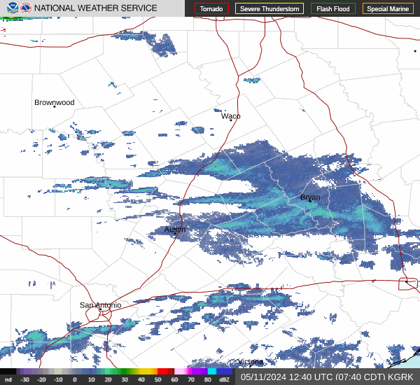
Backbuilding SW of San Antonio now. Gonna be pretty rough in a handful of hours around here.


Looks like the HRRR is picking up on the possibility of some discrete cells now..interesting.
CAM's or Short-term models didn't do a good job at all with initializing these severe thunderstorms off to the northeast of the Houston area now...
- COD-NEXRAD-HGX (1).png (2.02 MiB) Viewed 495 times
Development has started to the west....
- Screenshot 2024-04-09 at 22-03-02 NWS Radar.png (154.2 KiB) Viewed 492 times
Some pretty strong wording from the SPC regarding later tonight. A new watch will go up locally by midnight.
- IMG_0015.png (504.92 KiB) Viewed 471 times
Mesoscale Discussion 0407
NWS Storm Prediction Center Norman OK
1012 PM CDT Tue Apr 09 2024
Areas affected...Parts of south and southeast TX
Concerning...Severe Thunderstorm Watch 96...98...
Valid 100312Z - 100445Z
The severe weather threat for Severe Thunderstorm Watch 96, 98
continues.
SUMMARY...An increasing severe-wind threat is expected late tonight,
along with a continued hail risk. Downstream watch issuance is
likely by midnight CDT.
DISCUSSION...A supercell cluster near/east of Austin has shown signs
of accelerating eastward late this evening, with a substantial hail
core recently noted in MRMS data near Bastrop. MLCAPE of greater
than 2000 J/kg and favorable deep-layer shear will continue to
support large hail (potentially greater than 2 inches in diameter)
with embedded supercells in the cluster. Consolidating outflows may
also pose an increasing severe-wind threat as this cluster moves
eastward late tonight.
Farther southwest, deep convection has recently erupted across
southern portions of the Hill Country into western parts of deep
south TX, where a cold front has intercepted returning low-level
moisture. Instability and deep-layer shear are favorable for
supercells in this region as well, and a threat for large to very
large hail will accompany these storms as they move eastward. Most
recent CAM guidance suggests eventual upscale growth in this region,
which will then move quickly east-northeastward toward the TX Gulf
Coast with time, accompanied by a threat for severe wind gusts
potentially exceeding 75 mph. Some tornado threat could also
eventually evolve near the TX Coast overnight, as the upscale
growing storm cluster encounters deeper moisture and stronger
low-level flow/shear.
With a substantial severe threat expected to eventually spread
toward the TX Gulf Coast, downstream watch issuance is likely by
midnight CDT.

Incoming.
- Attachments
-
- GKv9FtyWwAAsonK-1.jpg (61.46 KiB) Viewed 446 times


Could get quite hairy tonight.
All modes of severe weather are on the table over the next several hours. Going to be an interesting one! Big change in the models from what they were showing 12 hours ago.
Yikes! "widespread damaging winds with isolated gust up to 85 mph likely"
- ww0099_overview.gif (47.5 KiB) Viewed 417 times
URGENT - IMMEDIATE BROADCAST REQUESTED
Severe Thunderstorm Watch Number 99
NWS Storm Prediction Center Norman OK
1150 PM CDT Tue Apr 9 2024
The NWS Storm Prediction Center has issued a
* Severe Thunderstorm Watch for portions of
Southeast Texas
Coastal Waters
* Effective this Tuesday night and Wednesday morning from 1150 PM
until 700 AM CDT.
* Primary threats include...
Widespread damaging winds and isolated significant gusts to 85
mph likely
Scattered large hail and isolated very large hail events to 2
inches in diameter possible
A tornado or two possible
SUMMARY...An intense line of thunderstorms over south Texas will
track eastward overnight across the watch area. The potential
exists for considerable coverage of damaging wind gust and some
hail. Isolated tornadoes are also possible along the leading edge
of the squall line.
The severe thunderstorm watch area is approximately along and 65
statute miles east and west of a line from 65 miles north northwest
of Houston TX to 30 miles southeast of Palacios TX. For a complete
depiction of the watch see the associated watch outline update
Well, ****
don wrote: ↑Wed Apr 10, 2024 12:02 am Yikes! "widespread damaging winds with isolated gust up to 85 mph likely"
ww0099_overview.gif
URGENT - IMMEDIATE BROADCAST REQUESTED
Severe Thunderstorm Watch Number 99
NWS Storm Prediction Center Norman OK
1150 PM CDT Tue Apr 9 2024
The NWS Storm Prediction Center has issued a
* Severe Thunderstorm Watch for portions of
Southeast Texas
Coastal Waters
* Effective this Tuesday night and Wednesday morning from 1150 PM
until 700 AM CDT.
* Primary threats include...
Widespread damaging winds and isolated significant gusts to 85
mph likely
Scattered large hail and isolated very large hail events to 2
inches in diameter possible
A tornado or two possible
SUMMARY...An intense line of thunderstorms over south Texas will
track eastward overnight across the watch area. The potential
exists for considerable coverage of damaging wind gust and some
hail. Isolated tornadoes are also possible along the leading edge
of the squall line.
The severe thunderstorm watch area is approximately along and 65
statute miles east and west of a line from 65 miles north northwest
of Houston TX to 30 miles southeast of Palacios TX. For a complete
depiction of the watch see the associated watch outline update
I know everyone here already knows this, but Guys and gals, make sure your emergency notifications are turned on on your phones. I have mine on and physical weather radio right next to the bed. Dogs are already sleeping under my bed. Poor gals.
Stay safe.
Stay safe.
Well, that first line was weak. I put tarp over one of the cars. That was the clincher. The hail core turned right and dissipated.
That MCV east of San Antonio has bad intentions. I think it's going to slip south of here.
That MCV east of San Antonio has bad intentions. I think it's going to slip south of here.