
April 2024
-
Stratton20
- Posts: 4259
- Joined: Tue Feb 09, 2021 11:35 pm
- Location: College Station, Texas
- Contact:
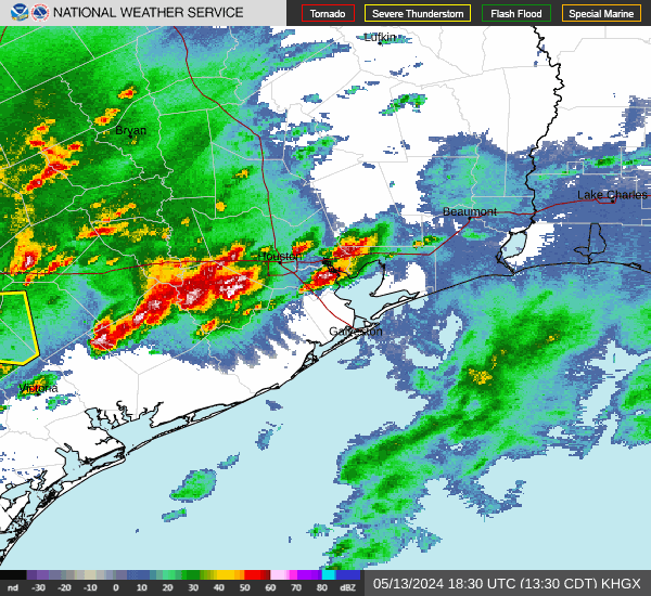
Maybe a line of storms looks like its beginning to develop near the hill country, hopefully those can hold together as they progress eastward over the next several hours
-
redneckweather
- Posts: 1023
- Joined: Mon Feb 08, 2010 7:29 pm
- Location: Montgomery, Texas
- Contact:
Just a light drizzle here in Conroe so far.
Boy, that is some kinda storm down there in Mexico. Can’t imagine the size of the hail in that baby!

That's the weak MCS that's developed as forecast.Should be in the metro area in a couple of hours.Stratton20 wrote: ↑Sat Apr 20, 2024 8:49 pm Maybe a line of storms looks like its beginning to develop near the hill country, hopefully those can hold together as they progress eastward over the next several hours
- canr45rvas.png (705.67 KiB) Viewed 879 times
Cold air just blew through here. Expect that will shut down any instability in a hurry.

Two boundaries working south
- Attachments
-
- IMG_1086.png (3.84 MiB) Viewed 844 times

The boundaries still have their act together. I see a potential hail core. We receive the colder blast before the rain as well.
1.37” here. Onto the next…
Thundered a bit around 3, but might have got 1/10 of an inch, if that. At least it will feel like fall for a day.
An amazing 4.15 inches up here in the NW territories. That's the most rain from an event that we've had in years.
Going back into my weather log...on December 27, 2018 we had 4.23 inches of rain.
I may have missed something. My logkeeping became sketchy in late 2020-2022 during COVID.
An absolutely beautiful day - I did some fence repair.
Going back into my weather log...on December 27, 2018 we had 4.23 inches of rain.
I may have missed something. My logkeeping became sketchy in late 2020-2022 during COVID.
An absolutely beautiful day - I did some fence repair.
Lol that’s some boring *** weather up there if that’s the first 4” rain event you’ve had in 6 years.DoctorMu wrote: ↑Sun Apr 21, 2024 10:25 pm An amazing 4.15 inches up here in the NW territories. That's the most rain from an event that we've had in years.
Going back into my weather log...on December 27, 2018 we had 4.23 inches of rain.
I may have missed something. My logkeeping became sketchy in late 2020-2022 during COVID.
An absolutely beautiful day - I did some fence repair.
The SPC once again has a severe weather outbreak for north Texas and Oklahoma again later this week. We’ll see if it pans out this time. They don’t have anything for our area yet.
-
tireman4

- Global Moderator

- Posts: 4510
- Joined: Wed Feb 03, 2010 9:24 pm
- Location: Humble, Texas
- Contact:
000
FXUS64 KHGX 221121
AFDHGX
Area Forecast Discussion
National Weather Service Houston/Galveston TX
621 AM CDT Mon Apr 22 2024
...New AVIATION...
.SHORT TERM...
(Today through Tuesday Night)
Issued at 234 AM CDT Mon Apr 22 2024
Dry/quiet weather will prevail across SE TX through the short-term
even as surface high pressure begins drifting east with time. This
will allow for the light NE/E winds today to gradually become more
E/SE by tomorrow. And with mostly clear skies remaining place high
temperatures will be in the lower 70s across the CWA today, then a
bit warmer tomorrow in the mid to upper 70s. Tonight will continue
to be cool as lows fall into the upper 40s to lower 50s for inland
areas...lower 60s at the immediate coast. With light onshore winds
prevailing by tomorrow night, lows will be warmer in the lower and
mid 60s. 41
&&
.LONG TERM...
(Wednesday through Sunday)
Issued at 234 AM CDT Mon Apr 22 2024
A persistent onshore wind regime will continue through the remainder
of the week and into the weekend, with this surface wind pattern
promoting a gradual increase in both temperatures and moisture over
this time period. For Wednesday and Thursday, this will result in
highs in the low to mid 80s with overnight lows rising to around 70
for most of the area. By Friday, global models continue to depict
entrance of a robust midlevel trough into the Central Rockies, which
will induce strong lee cyclogenesis as the associated surface system
deepens to near or below 990mb. The resultant surface pressure
gradient over the middle third of the CONUS will become quite strong,
increasing WAA/moist advection to SE TX. As such, we should see
highs heading into the weekend approach the mid to upper 80s, with a
few spots possibly breaking the 90 mark for the first time in quite a
while. Surface dew points in the 70s will become widespread by late
Friday, and WBGT values throughout the weekend will max out in the
lower 80s. As with all early season periods of elevated temperatures,
those who are not acclimated to the heat should plan to take safety
precautions when doing any strenuous activity outdoors.
Rainfall chances over the long term period will largely be limited,
as a weak surface boundary associated with the aforementioned
surface low looks to stall to our north. This will result in a low
but nonzero chance of showers and storms for the northern zones
beginning on Friday. Otherwise, rainfall will be limited to isolated
weak diurnal activity.
Cady
&&
.AVIATION...
(12Z TAF Issuance)
Issued at 619 AM CDT Mon Apr 22 2024
No issues with mainly VFR conditions prevailing and a gradual shift
of light east winds to the southeast late this afternoon through to-
morrow. 41
&&
.MARINE...
Issued at 234 AM CDT Mon Apr 22 2024
Winds continue to sit near 20 knots along the coast and offshore,
and as such a Small Craft Advisory remains in effect until 7 AM CT.
These winds should diminish during the late morning/early afternoon
as the wind direction shifts to the SE. Strengthening onshore flow is
expected throughout the remainder of the week and into the weekend,
with advisories likely to be needed once again on Friday. Rainfall
chances will remain low over at least the next 5 days.
Cady
&&
.PRELIMINARY POINT TEMPS/POPS...
College Station (CLL) 71 51 77 64 / 0 0 0 0
Houston (IAH) 73 53 80 65 / 0 0 0 0
Galveston (GLS) 70 63 75 70 / 0 0 0 0
&&
.HGX WATCHES/WARNINGS/ADVISORIES...
TX...None.
GM...Small Craft Advisory until 7 AM CDT this morning for GMZ330-335-
350-355-370-375.
&&
$$
SHORT TERM...41
LONG TERM....Cady
AVIATION...41
MARINE...Cady
Welcome to my world. We just hope the seabreeze can make it past Navasota in the summer!Cpv17 wrote: ↑Mon Apr 22, 2024 12:40 amLol that’s some boring *** weather up there if that’s the first 4” rain event you’ve had in 6 years.DoctorMu wrote: ↑Sun Apr 21, 2024 10:25 pm An amazing 4.15 inches up here in the NW territories. That's the most rain from an event that we've had in years.
Going back into my weather log...on December 27, 2018 we had 4.23 inches of rain.
I may have missed something. My logkeeping became sketchy in late 2020-2022 during COVID.
An absolutely beautiful day - I did some fence repair.
Horticulture in Aggieland is not for the weak of heart! The water is alkaline so no gardenias, azaelas, etc.


That is some good rain right there.DoctorMu wrote: ↑Sun Apr 21, 2024 10:25 pm An amazing 4.15 inches up here in the NW territories. That's the most rain from an event that we've had in years.
Going back into my weather log...on December 27, 2018 we had 4.23 inches of rain.
I may have missed something. My logkeeping became sketchy in late 2020-2022 during COVID.
An absolutely beautiful day - I did some fence repair.
-
tireman4
- Global Moderator
- Posts: 4510
- Joined: Wed Feb 03, 2010 9:24 pm
- Location: Humble, Texas
- Contact:
000
FXUS64 KHGX 231151
AFDHGX
Area Forecast Discussion
National Weather Service Houston/Galveston TX
651 AM CDT Tue Apr 23 2024
...New AVIATION...
.SHORT TERM...
(Today through Wednesday Night)
Issued at 357 AM CDT Tue Apr 23 2024
For the most part, not a lot issues are expected for the short-term
as the weather remains generally quiet/dry across SE TX. Flat zonal
winds at the mid/upper levels are progged to become more northwest-
erly through tomorrow as the next longwave trough approaches/begins
to develop over the southern US west coast. This along with a deep-
ening onshore flow at the lower levels here should result in warmer
temperatures the next couple of days (and beyond). Additionally, we
could also see some very isolated mainly afternoon showers tomorrow.
But, not at all confident with this scenario at this time given the
building ridge aloft.
As for temperatures, the warming trend will continue. Highs will be
in the upper 70s to around 80 today...lower to mid 80s on Weds. Low
temperatures will run similarly...lower to mid 60s tonight...mid to
upper 60s Weds night. 41
&&
.LONG TERM...
(Thursday through Monday)
Issued at 357 AM CDT Tue Apr 23 2024
Summer creeps closer and closer during the long term as persistent
southerly flow at the surface and southwesterly flow aloft bringing
increasing temperatures and humidity. Afternoon high temperatures
will be in the low to mid 80s on Thursday, mainly mid 80s on Friday,
and then upper 80s Saturday through Monday. Dew points will be in
the upper 60s to low 70s through the long term thanks to that moist,
southerly flow, leading to heat indicies will be rising into the low
90s by Saturday. bleh. Overnight lows will see a similar warming
trend with minimum temperatures upper 60s to low 70s Thursday night
becoming low to mid 70s by the weekend.
The upper level ridge overnight will begin to break down on Friday
allowing for some short wave to pass through the Southern Plains
through the weekend. Main impact to SE Texas will be increased
cloudiness, but can`t out rule some isolated showers or storms making
their way into the northern third (generally north of Conroe) over
the weekend into early next week.
Fowler
&&
.AVIATION...
(12Z TAF Issuance)
Issued at 639 AM CDT Tue Apr 23 2024
VFR conditions will prevail through much of the day, with south winds
(6-11kts) developing by this afternoon. As low-level moisture contin-
ues to deepen, periods of MVFR ceilings (and perhaps some patchy fog)
will be possible tonight. Winds will decrease overnight to 4-7kts for
most terminals. 41
&&
.MARINE...
Issued at 357 AM CDT Tue Apr 23 2024
Light onshore flow and low seas will continue through Thursday. The
onshore flow begins to strengthen Thursday night into Friday morning
ahead of some approaching weak disturbances. The winds will
strengthen to around 15-25kts with occasion higher gusts, so small
craft may will likely need to exercise caution as early as Thursday
night and Small Craft Advisories may be needed heading into the
weekend. The increase in winds will also lead to an increase in seas
to around 5 to 8 feet. Conditions improve into next week as high
pressure build overhead.
Fowler
&&
.PRELIMINARY POINT TEMPS/POPS...
College Station (CLL) 78 65 82 67 / 0 10 10 0
Houston (IAH) 79 66 83 68 / 0 0 10 0
Galveston (GLS) 75 70 77 70 / 0 0 0 0
&&
.HGX WATCHES/WARNINGS/ADVISORIES...
TX...None.
GM...None.
&&
$$
SHORT TERM...41
LONG TERM....Fowler
AVIATION...41
MARINE...Fowler