
2024 Hurricane Season Discussion
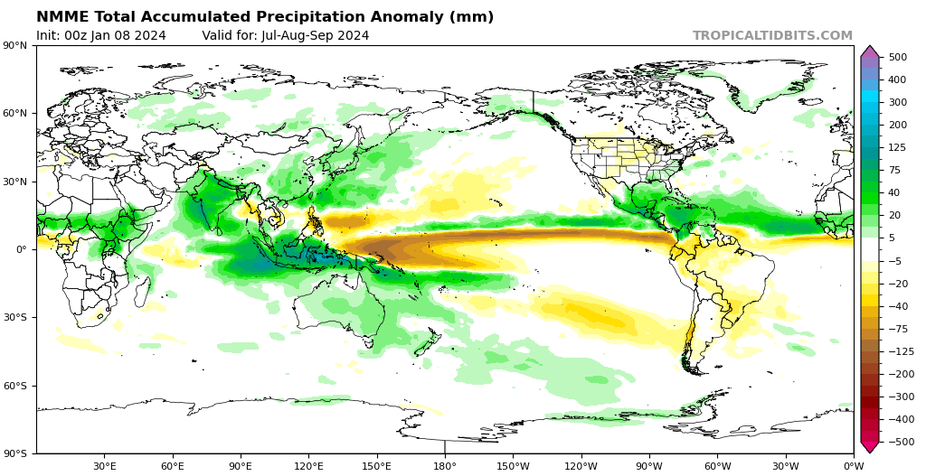
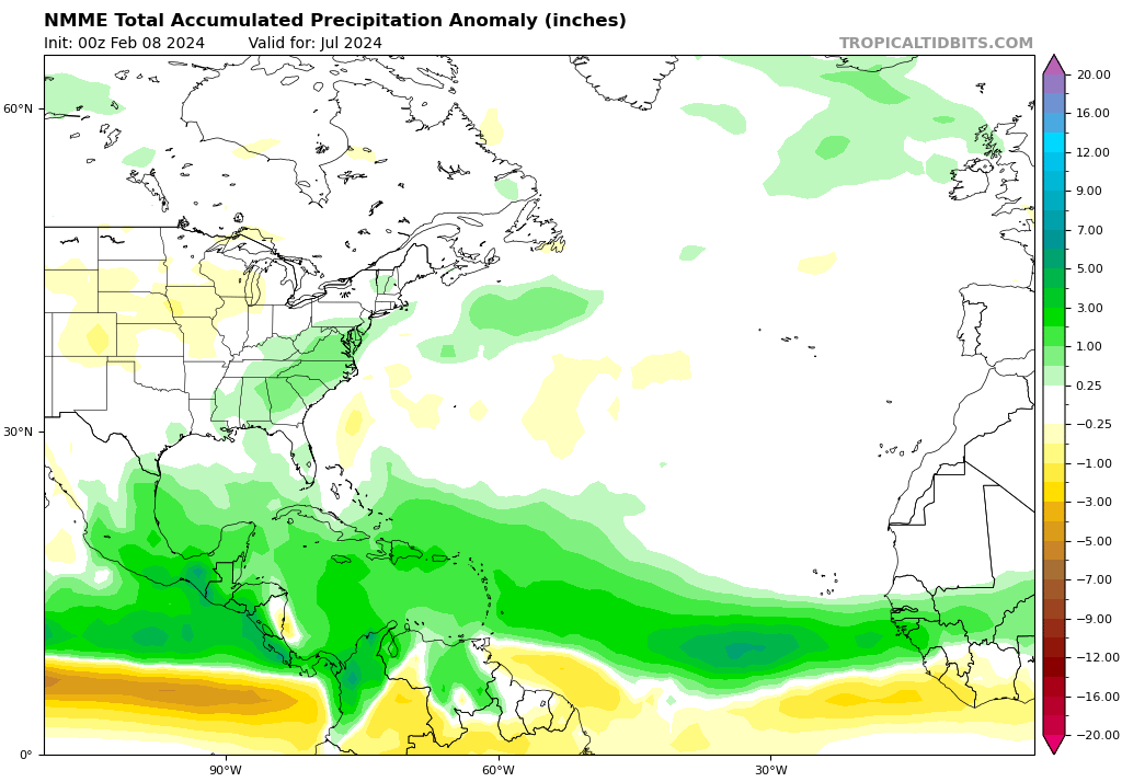
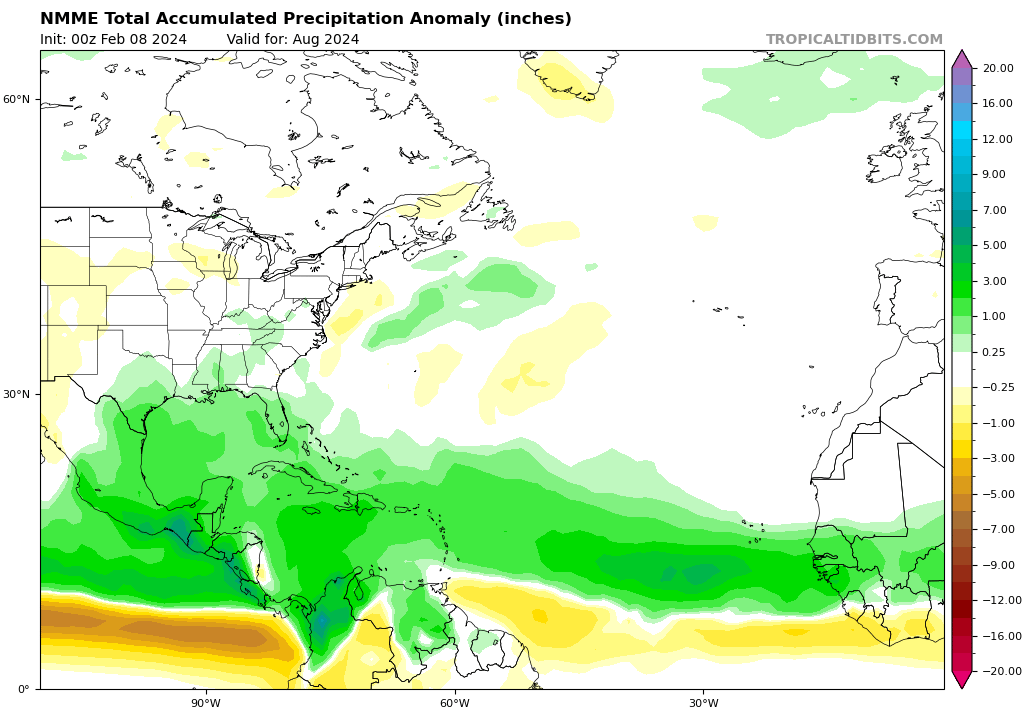
New run of the NMME came out:
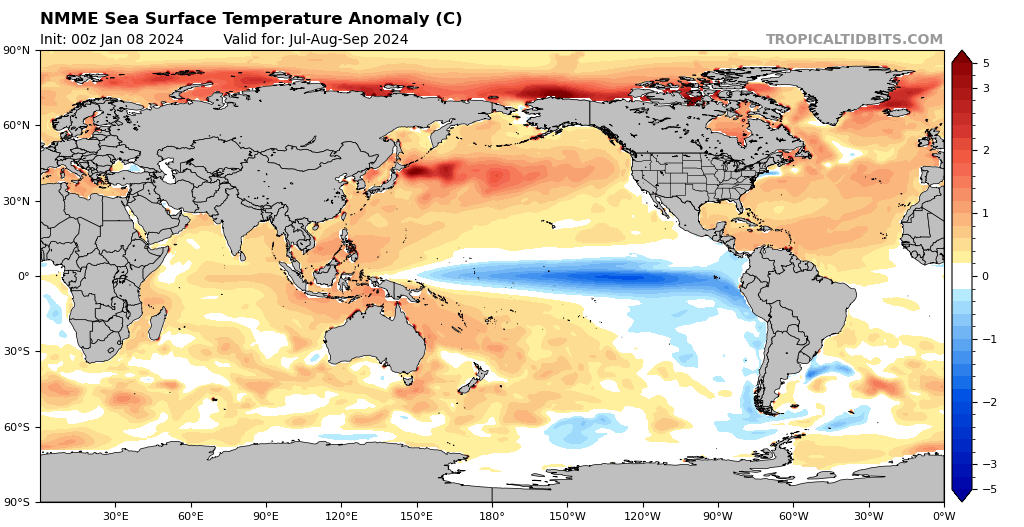
Very favorable look.
Very favorable look.
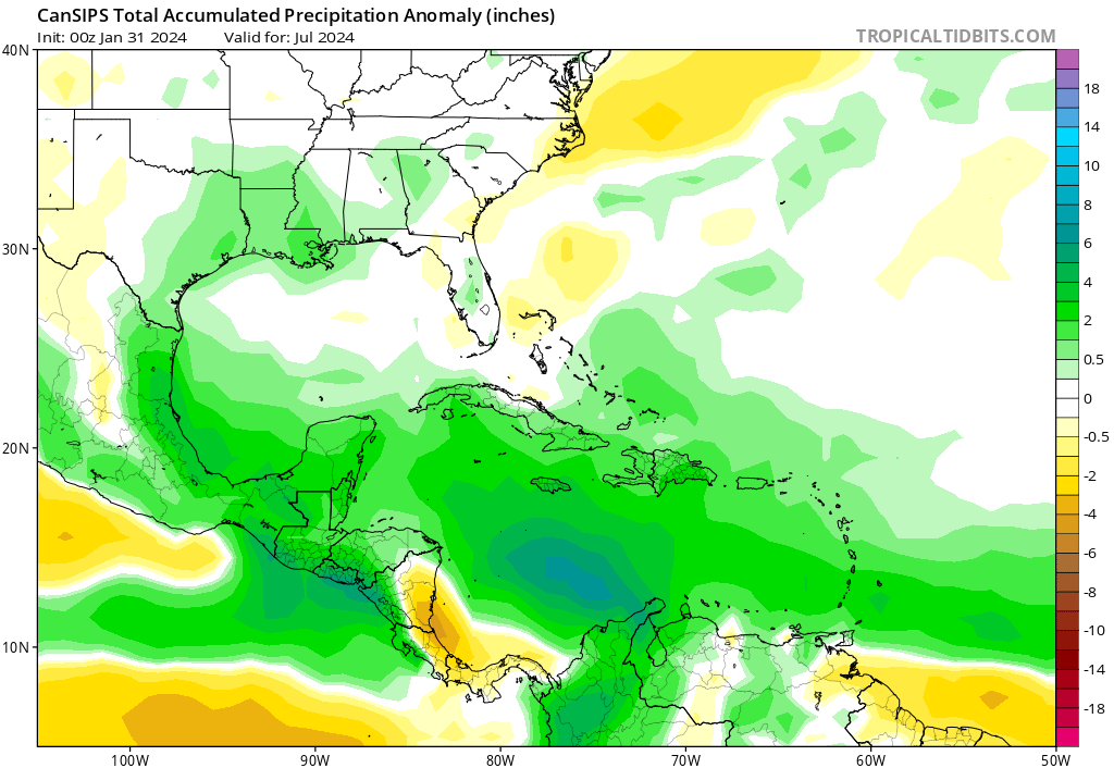
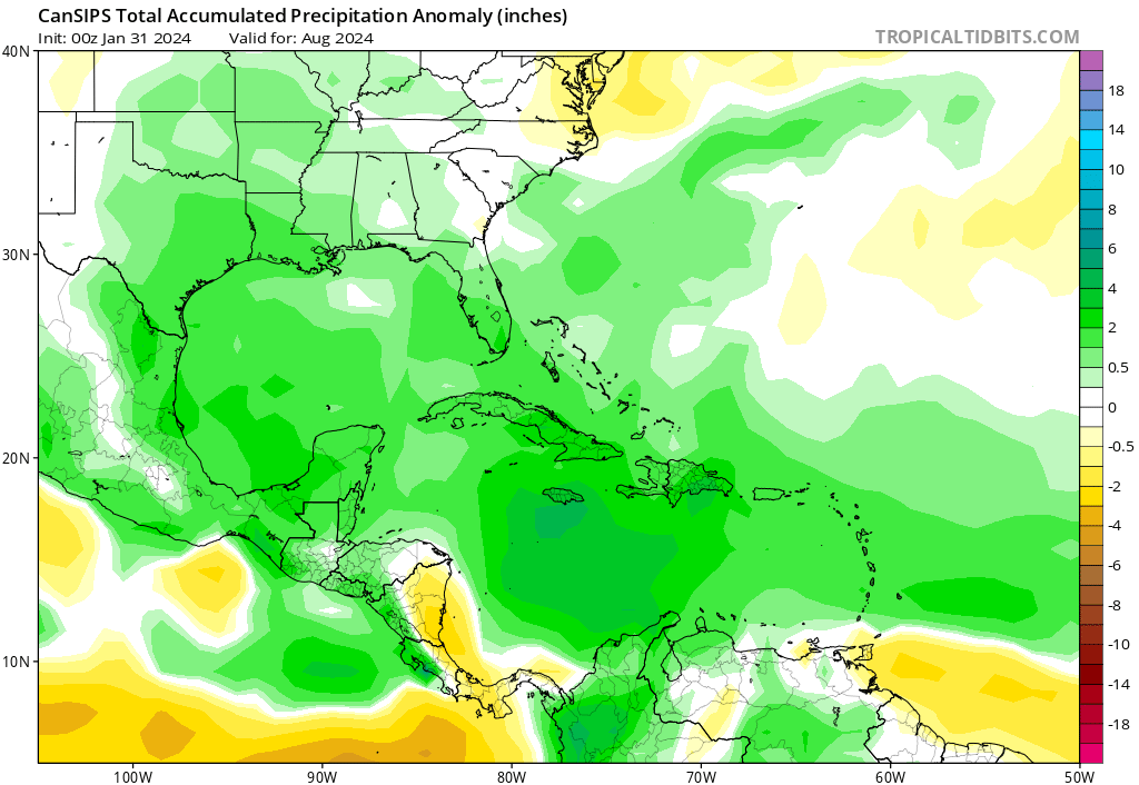
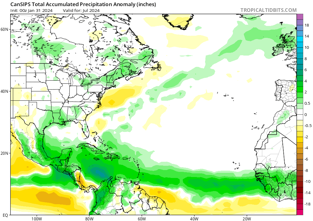
New CanSIPS forecast is out:
July
August
July
August
I’ve got a bad, sinking feeling regarding SETX this hurricane season. Nothing specific….just a bad feeling.
This is not based on any data whatsoever other than what has already been presented.
This is not based on any data whatsoever other than what has already been presented.
I’m thinking August is the month we need to watch the most as of right now.
Wider views of the NMME and CanSIPS:
NMME for July:
August:
CanSIPS for July:
August:
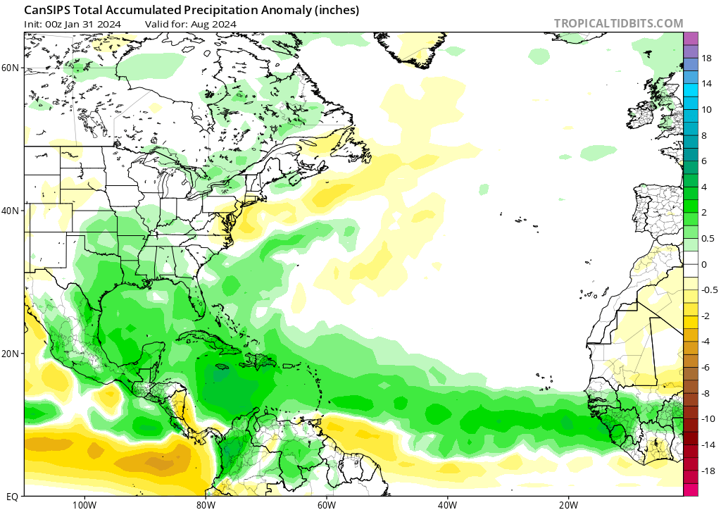
As you can see, not really much of a difference between the two models. Pretty good agreement.
NMME for July:
August:
CanSIPS for July:
August:
As you can see, not really much of a difference between the two models. Pretty good agreement.


I hope that doesn’t happpen. I’m extremely concerned about us getting hit this year in the Galveston area.
-
Stratton20
- Posts: 4248
- Joined: Tue Feb 09, 2021 11:35 pm
- Location: College Station, Texas
- Contact:
Sambucol cant blame you there, we have escaped ao many close calls from storms like Laura, Delta etc, we may not be as lucly this year, hopefully we dont get hit
After the dryness experienced the past two summers, I want a shakeup. And if that means getting all these tropical cyclones, then let's bring it.
But seriously: I'd like to see the wetter solutions verify so that we can see a clearer idea of what goes on to dictate hotter/drier versus cooler/wetter regarding the summer weather. Are these predictions simply just drawing from general Nina baselines, or is there another factor or other at play? Does the "staying power" of the ridge stem from any localized/topographic influences of the Texas/Mexico region, or is it more related to remote forcing from ENSO/other teleconnections (and any possible relationship with East Pacific ITCZ in case that plays a role)?
-PDO sucks.user:null wrote: ↑Wed Feb 21, 2024 12:03 pmAfter the dryness experienced the past two summers, I want a shakeup. And if that means getting all these tropical cyclones, then let's bring it.
But seriously: I'd like to see the wetter solutions verify so that we can see a clearer idea of what goes on to dictate hotter/drier versus cooler/wetter regarding the summer weather. Are these predictions simply just drawing from general Nina baselines, or is there another factor or other at play? Does the "staying power" of the ridge stem from any localized/topographic influences of the Texas/Mexico region, or is it more related to remote forcing from ENSO/other teleconnections (and any possible relationship with East Pacific ITCZ in case that plays a role)?
Yes, that is a factor that I've seen referenced a lot on s2k regarding the favor of summer heat and drought in Texas. I'm genuinely trying to figure out if the persistence of ridging/drought in the Texas area is due more to remote forcing from teleconnections like the PDO, or if there were local influences at play.
In order to confirm, I'll have to find the previous times that we've had a +PDO, so as to see the outcomes. I'm aware that AMO is also another factor, but that has long since been positive a while now.


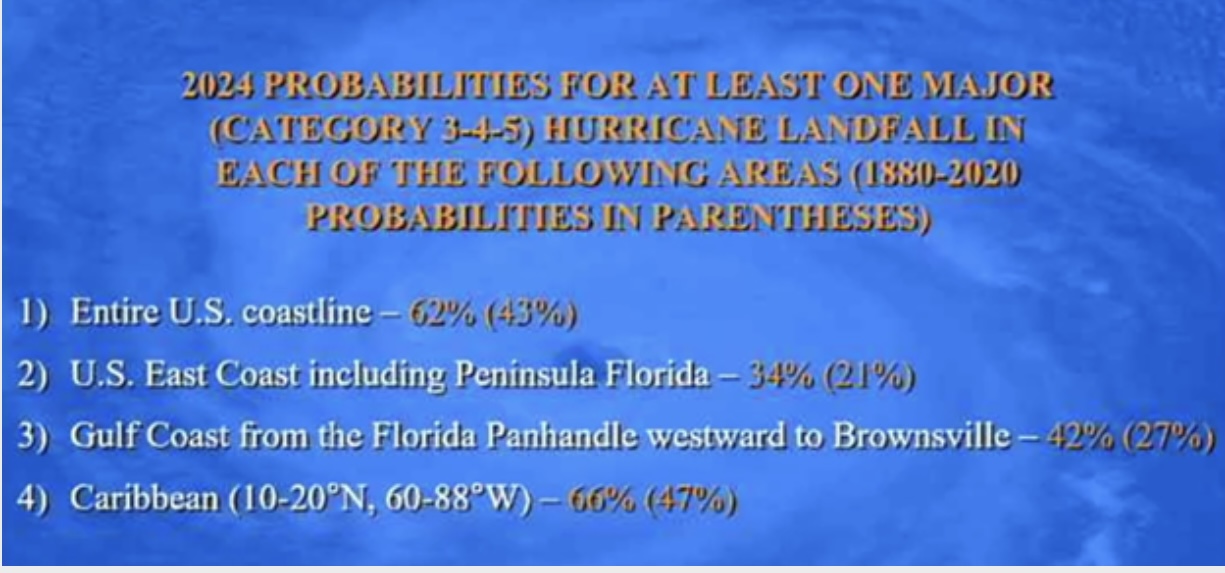
Many of the forecast I have seen have an active 2024 season.
Same here. I’m dreading hurricane season this year.


One thing to take away from this, notice over the last 30 years, we are experiencing the warmest SST anomalies since '97/98 and '15. Takeaway? Those were El Niño years.
The summer of 1997 was a below average hurricane season, with only 8 named storms, 3 of which became hurricanes, one of those major with only one of the eight storms hitting the U.S. mainland. Summer of 2015 was also a slightly below average season, 11 total storms, 4 hurricanes, 2 of those being majors. Only two hit the U.S. mainland, one of those being along the central TX coast (tropical storm Bill).
However, on the contrary, with us being in El Niño last summer, the Atlantic had an above average season with 20 named storms (which ranks fourth for the most-named storms in a year since 1950!) The 1997-98 El Niño was followed by a strong La Niña (which you can depict in the picture above with the blue/purple colors in the Pacific region), which correlated to what became an above average hurricane season, with several storms hitting the mainland. A mild La Niña followed the 2015-16 El Niño, which also ended up being an above average season, with several of those storms hitting parts of the mainland (mainly the southeastern part of the country) and also in Central America.
The point in all of this: no El Niños or La Niñas are the same (hence the busy season we had last summer, despite being in an El Niño). However, with odds increasing we'll transition into a La Niña this summer, and coming off some of the warmer SSTs from the years I've mentioned above, history could repeat itself with an above average season, possibly hyperactive. As always though, all it takes is one to hit you for it to be a bad season. I'll be closely monitoring how quickly the SSTs out in the Pacific cool in the months ahead.
Blake
Boomer Sooner
Boomer Sooner
I’m tired of seeing so many people say “oh they say it’s gonna be busy every year”. That narrative is lazy garbage and people need to educate themselves before they comment on something. Drives me crazy!