
TS Fiona
-
biggerbyte
- Posts: 1142
- Joined: Thu Feb 04, 2010 12:15 am
- Location: Porter, Texas. (Montgomery County)
- Contact:
One thing is for sure, this is not a done deal with Fiona. I don't think anyone was/is concerned about Earl, but this system has been on the scope for quite some time. Now I'm talking about Caribbean and Gulf purposes. The models may be saying no, but I say just maybe.
-
srainhoutx

- Site Admin

- Posts: 19620
- Joined: Tue Feb 02, 2010 2:32 pm
- Location: Maggie Valley, NC
- Contact:
I would think so, sambucol. The NHC seemed confident in the first 48 hours. Beyond that, I'm not so sure. Regardless, it's that time of year and another disturbance is following behind Fiona at a rather low latitude as well.sambucol wrote:At this point, we should be watching the trends and not so much the tracks. Right?
Carla/Alicia/Jerry(In The Eye)/Michelle/Charley/Ivan/Dennis/Katrina/Rita/Wilma/Humberto/Ike/Harvey
Member: National Weather Association
Facebook.com/Weather Infinity
Twitter @WeatherInfinity
Member: National Weather Association
Facebook.com/Weather Infinity
Twitter @WeatherInfinity
-
srainhoutx
- Site Admin
- Posts: 19620
- Joined: Tue Feb 02, 2010 2:32 pm
- Location: Maggie Valley, NC
- Contact:
Getting some convection...
Carla/Alicia/Jerry(In The Eye)/Michelle/Charley/Ivan/Dennis/Katrina/Rita/Wilma/Humberto/Ike/Harvey
Member: National Weather Association
Facebook.com/Weather Infinity
Twitter @WeatherInfinity
Member: National Weather Association
Facebook.com/Weather Infinity
Twitter @WeatherInfinity
-
biggerbyte
- Posts: 1142
- Joined: Thu Feb 04, 2010 12:15 am
- Location: Porter, Texas. (Montgomery County)
- Contact:
Hmm! Will big bear swallow up little bear? Stay tuned to see if Fiona survives living near Earl.
-
Andrew
- Site Admin
- Posts: 3440
- Joined: Wed Feb 03, 2010 9:46 pm
- Location: North-West Houston
- Contact:
srainhoutx wrote:Getting some convection...
It is indeed picking up some convection. Lets see if it lasts though as I still believe it is a little too close to really get going. Hmm three storms in the Atlantic and a possible fourth (which is at a low lat) and not much board activity.
For Your Infinite Source For All Things Weather Visit Our Facebook


We should keep an eye on Fiona.
Well King Euro has went from this -

To this -

In a span of a few days. Nothing wrong with cases like this to reiterate the swings the models can have at times (even with King Euro) and to not get that caught up in some of the solutions that are shown.
At this time major props to the GFS for its consistency.
To this -
In a span of a few days. Nothing wrong with cases like this to reiterate the swings the models can have at times (even with King Euro) and to not get that caught up in some of the solutions that are shown.
At this time major props to the GFS for its consistency.
-
srainhoutx
- Site Admin
- Posts: 19620
- Joined: Tue Feb 02, 2010 2:32 pm
- Location: Maggie Valley, NC
- Contact:
000
WTNT43 KNHC 311439
TCDAT3
TROPICAL STORM FIONA DISCUSSION NUMBER 4
NWS TPC/NATIONAL HURRICANE CENTER MIAMI FL AL082010
1100 AM AST TUE AUG 31 2010
A 0929 UTC SSMIS MICROWAVE OVERPASS SHOWED CURVED BANDS OF
CONVECTION LOOSELY WRAPPING AROUND THE CENTER. SINCE THAT TIME
VISIBLE SATELLITE IMAGERY INDICATES THAT THE CONVECTIVE BANDS NEAR
THE CENTER HAVE WEAKENED...WHILE NEW CONVECTION HAS DEVELOPED
AROUND THE PERIPHERY OF THE CIRCULATION. THE INITIAL INTENSITY
REMAINS 35 KT...BASED ON THE EARLIER SCATTEROMETER DATA. AN AIR
FORCE RESERVE HURRICANE HUNTER AIRCRAFT IS SCHEDULED TO
INVESTIGATE FIONA THIS AFTERNOON AND SHOULD PROVIDE A BETTER
ASSESSMENT OF THE CURRENT STRUCTURE AND INTENSITY.
THE INITIAL MOTION ESTIMATE IS 285/21 KT. THE CYCLONE IS FORECAST
TO SLOW DOWN AND TURN NORTHWESTWARD DURING THE NEXT 24 HOURS AS IT
NEARS THE WESTERN PORTION OF THE SUBTROPICAL RIDGE. THEREAFTER...
FIONA IS EXPECTED TO TURN NORTH-NORTHWESTWARD...THEN NORTHWARD
BETWEEN THE WESTERN SIDE OF THE RIDGE AND HURRICANE EARL TO THE
NORTHWEST. THE TRACK GUIDANCE IS IN BETTER AGREEMENT ON THIS
SCENARIO AND THE OFFICIAL FORECAST HAS BEEN ADJUSTED EASTWARD ALONG
THE LEFT SIDE OF THE GUIDANCE ENVELOPE. LATE IN THE FORECAST
PERIOD...FIONA SHOULD TURN NORTHEASTWARD AS DEEP SOUTHWESTERLY FLOW
DEVELOPS OVER THE WESTERN ATLANTIC.
THERE APPEARS TO BE A SMALL WINDOW OF OPPORTUNITY FOR FIONA TO
STRENGTHEN DURING THE NEXT 12 TO 24 HOURS BEFORE AN UPPER-LEVEL
RIDGE TO THE NORTHWEST OF FIONA STRENGTHENS...AND NORTHEASTERLY
UPPER-LEVEL WINDS INCREASE. THE SHEAR IS FORECAST TO REMAIN
MODERATE TO STRONG THROUGHOUT MOST OF THE FORECAST PERIOD AND NO
ADDITIONAL STRENGTHENING IS PREDICTED. AN ALTERNATE SCENARIO...AS
SHOWN BY THE GFS...IS THAT FIONA COULD WEAKEN AND POSSIBLY
DISSIPATE IN A COUPLE OF DAYS DUE TO THE AFOREMENTIONED SHEAR.
FORECAST POSITIONS AND MAX WINDS
INITIAL 31/1500Z 15.9N 55.3W 35 KT
12HR VT 01/0000Z 16.9N 58.2W 40 KT
24HR VT 01/1200Z 18.7N 61.3W 45 KT
36HR VT 02/0000Z 21.1N 63.8W 45 KT
48HR VT 02/1200Z 23.4N 65.8W 45 KT
72HR VT 03/1200Z 27.7N 67.8W 45 KT
96HR VT 04/1200Z 31.0N 67.5W 45 KT
120HR VT 05/1200Z 34.0N 66.0W 45 KT
$$
FORECASTER BROWN
Carla/Alicia/Jerry(In The Eye)/Michelle/Charley/Ivan/Dennis/Katrina/Rita/Wilma/Humberto/Ike/Harvey
Member: National Weather Association
Facebook.com/Weather Infinity
Twitter @WeatherInfinity
Member: National Weather Association
Facebook.com/Weather Infinity
Twitter @WeatherInfinity
-
biggerbyte
- Posts: 1142
- Joined: Thu Feb 04, 2010 12:15 am
- Location: Porter, Texas. (Montgomery County)
- Contact:
Poor Fiona.... Not looking good for her. Amazing what new things a new day brings. Early on, and even up to just two days ago, many folks, and many models, had Fiona being someone's problem.
Meanwhile, big-bad-Earl is being monitored.
Down the road... What comes after Fiona... Is it in the works...
Stay tuned.
The chatter has already begun.
BB
Meanwhile, big-bad-Earl is being monitored.
Down the road... What comes after Fiona... Is it in the works...
Stay tuned.
The chatter has already begun.
BB
-
biggerbyte
- Posts: 1142
- Joined: Thu Feb 04, 2010 12:15 am
- Location: Porter, Texas. (Montgomery County)
- Contact:
98l is born...
Watch that thread too, newbies. This one is coming in further south than even Fiona did.
Westward it goes.
Watch that thread too, newbies. This one is coming in further south than even Fiona did.
Westward it goes.
-
wxman57

- Global Moderator

- Posts: 2621
- Joined: Thu Feb 04, 2010 5:34 am
- Location: Southwest Houston (Westbury)
- Contact:
Looks like Earl may well absorb Fiona tomorrow. Squalls from Fiona are accelerating toward the NW right into Earl now. So much for the European's forecast of a big New Orleans storm out of Fiona.
-
srainhoutx
- Site Admin
- Posts: 19620
- Joined: Tue Feb 02, 2010 2:32 pm
- Location: Maggie Valley, NC
- Contact:
Perhaps the quick demise of Fiona was a bit premature?
Carla/Alicia/Jerry(In The Eye)/Michelle/Charley/Ivan/Dennis/Katrina/Rita/Wilma/Humberto/Ike/Harvey
Member: National Weather Association
Facebook.com/Weather Infinity
Twitter @WeatherInfinity
Member: National Weather Association
Facebook.com/Weather Infinity
Twitter @WeatherInfinity
-
biggerbyte
- Posts: 1142
- Joined: Thu Feb 04, 2010 12:15 am
- Location: Porter, Texas. (Montgomery County)
- Contact:
Indeed, Steve.
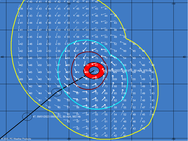
Gang, let's not take our eye off the ball. It looks like Fiona may now have her center further south. She is still moving westward, while Earl is moving more northward. Convection is blossoming as I speak. Also, some of the models are shifting west into the Caribbean. Too early to tell if she decided Earl is not her type, nor are we sure she will play follow the leader. Right now the outlook appears to be changing for another round with this system. It should not take much longer to know either way.
Gang, let's not take our eye off the ball. It looks like Fiona may now have her center further south. She is still moving westward, while Earl is moving more northward. Convection is blossoming as I speak. Also, some of the models are shifting west into the Caribbean. Too early to tell if she decided Earl is not her type, nor are we sure she will play follow the leader. Right now the outlook appears to be changing for another round with this system. It should not take much longer to know either way.
-
srainhoutx
- Site Admin
- Posts: 19620
- Joined: Tue Feb 02, 2010 2:32 pm
- Location: Maggie Valley, NC
- Contact:
Code: Select all
484
WHXX01 KWBC 011219
CHGHUR
TROPICAL CYCLONE GUIDANCE MESSAGE
NWS TPC/NATIONAL HURRICANE CENTER MIAMI FL
1219 UTC WED SEP 1 2010

DISCLAIMER...NUMERICAL MODELS ARE SUBJECT TO LARGE ERRORS.
PLEASE REFER TO NHC OFFICIAL FORECASTS FOR TROPICAL CYCLONE
AND SUBTROPICAL CYCLONE INFORMATION.

ATLANTIC OBJECTIVE AIDS FOR

TROPICAL CYCLONE FIONA (AL082010) 20100901 1200 UTC

        ...00 HRS...   ...12 HRS...   ...24 HRS. ..   ...36 HRS...
        100901  1200   100902  0000   100902  1200   100903  0000

         LAT    LON     LAT    LON     LAT    LON     LAT    LON
BAMS    18.2N  60.9W   20.7N  63.7W   23.2N  66.0W   26.1N  67.5W
BAMD    18.2N  60.9W   20.0N  63.6W   21.7N  65.6W   22.5N  66.9W
BAMM    18.2N  60.9W   20.3N  63.6W   22.3N  65.7W   24.0N  67.1W
LBAR    18.2N  60.9W   20.2N  63.2W   22.1N  65.4W   23.6N  67.2W
SHIP        50KTS          55KTS          58KTS          59KTS
DSHP        50KTS          55KTS          58KTS          59KTS

        ...48 HRS...   ...72 HRS...   ...96 HRS. ..   ..120 HRS...
        100903  1200   100904  1200   100905  1200   100906  1200

         LAT    LON     LAT    LON     LAT    LON     LAT    LON
BAMS    29.2N  67.8W   35.5N  62.5W   41.0N  55.3W   46.4N  44.7W
BAMD    22.2N  68.3W   20.2N  73.1W   18.5N  79.4W   18.3N  86.4W
BAMM    24.9N  67.9W   24.7N  69.0W   23.6N  71.7W   23.3N  75.6W
LBAR    24.6N  68.6W   25.3N  70.4W   22.8N  70.8W   21.5N  74.7W
SHIP        56KTS          49KTS          49KTS          41KTS
DSHP        56KTS          49KTS          49KTS          41KTS

         ...INITIAL CONDITIONS...
LATCUR =  18.2N LONCUR =  60.9W DIRCUR = 305DEG SPDCUR =  13KT
LATM12 =  16.8N LONM12 =  58.5W DIRM12 = 288DEG SPDM12 =  15KT
LATM24 =  15.8N LONM24 =  54.4W
WNDCUR =   50KT RMAXWD =   30NM WNDM12 =   40KT
CENPRS =  998MB OUTPRS = 1010MB OUTRAD =  150NM SDEPTH =   S
RD34NE =  120NM RD34SE =  120NM RD34SW =    0NM RD34NW =  75NM

Carla/Alicia/Jerry(In The Eye)/Michelle/Charley/Ivan/Dennis/Katrina/Rita/Wilma/Humberto/Ike/Harvey
Member: National Weather Association
Facebook.com/Weather Infinity
Twitter @WeatherInfinity
Member: National Weather Association
Facebook.com/Weather Infinity
Twitter @WeatherInfinity

-
srainhoutx
- Site Admin
- Posts: 19620
- Joined: Tue Feb 02, 2010 2:32 pm
- Location: Maggie Valley, NC
- Contact:
000
WTNT33 KNHC 021138
TCPAT3
BULLETIN
TROPICAL STORM FIONA INTERMEDIATE ADVISORY NUMBER 11A
NWS TPC/NATIONAL HURRICANE CENTER MIAMI FL AL082010
800 AM AST THU SEP 02 2010
...FIONA MOVING NORTHWESTWARD...
SUMMARY OF 800 AM AST...1200 UTC...INFORMATION
----------------------------------------------
LOCATION...23.6N 65.5W
ABOUT 610 MI...980 KM S OF BERMUDA
MAXIMUM SUSTAINED WINDS...50 MPH...85 KM/HR
PRESENT MOVEMENT...NW OR 325 DEGREES AT 17 MPH...28 KM/HR
MINIMUM CENTRAL PRESSURE...1000 MB...29.53 INCHES
Carla/Alicia/Jerry(In The Eye)/Michelle/Charley/Ivan/Dennis/Katrina/Rita/Wilma/Humberto/Ike/Harvey
Member: National Weather Association
Facebook.com/Weather Infinity
Twitter @WeatherInfinity
Member: National Weather Association
Facebook.com/Weather Infinity
Twitter @WeatherInfinity
-
srainhoutx
- Site Admin
- Posts: 19620
- Joined: Tue Feb 02, 2010 2:32 pm
- Location: Maggie Valley, NC
- Contact:
000
WTNT33 KNHC 022034
TCPAT3
BULLETIN
TROPICAL STORM FIONA ADVISORY NUMBER 13
NWS TPC/NATIONAL HURRICANE CENTER MIAMI FL AL082010
500 PM AST THU SEP 02 2010
...LITTLE CHANGE WITH FIONA...STILL HAS 50 MPH WINDS...
SUMMARY OF 500 PM AST...2100 UTC...INFORMATION
----------------------------------------------
LOCATION...25.6N 66.4W
ABOUT 475 MI...760 KM SSW OF BERMUDA
MAXIMUM SUSTAINED WINDS...50 MPH...85 KM/HR
PRESENT MOVEMENT...NNW OR 335 DEGREES AT 17 MPH...28 KM/HR
MINIMUM CENTRAL PRESSURE...1002 MB...29.59 INCHES
Carla/Alicia/Jerry(In The Eye)/Michelle/Charley/Ivan/Dennis/Katrina/Rita/Wilma/Humberto/Ike/Harvey
Member: National Weather Association
Facebook.com/Weather Infinity
Twitter @WeatherInfinity
Member: National Weather Association
Facebook.com/Weather Infinity
Twitter @WeatherInfinity