Page 12 of 16
Re: March 2010- In Like A Lamb, Out Like A Lion?
Posted: Fri Mar 19, 2010 7:14 pm
by Katdaddy
WXman57 I am so ready for the real Spring. Up here in Dallas this weekend so I might get lucky and see more snow.
Re: March 2010- In Like A Lamb, Out Like A Lion?
Posted: Fri Mar 19, 2010 7:28 pm
by srainhoutx
Katdaddy wrote:WXman57 I am so ready for the real Spring. Up here in Dallas this weekend so I might get lucky and see more snow.
You and me both Katdaddy! Take some pics.

Re: March 2010- In Like A Lamb, Out Like A Lion?
Posted: Fri Mar 19, 2010 7:37 pm
by wxman57
Well, let's see if the 18Z GFS sees any spring on the horizon. Here are a couple of meteograms. As you can see, more days above 70, but nothing near 80 for the next 2 weeks. That's unbelievable, only a couple of 80 degree days through early April. And I do think Sunday will be overcast much of the day, so Monday should be the colder morning (35).


Re: March 2010- In Like A Lamb, Out Like A Lion?
Posted: Fri Mar 19, 2010 9:44 pm
by wxdata
0z NAM showing track of upper low a bit further south than earlier runs.
Click map for larger image.
Re: March 2010- In Like A Lamb, Out Like A Lion?
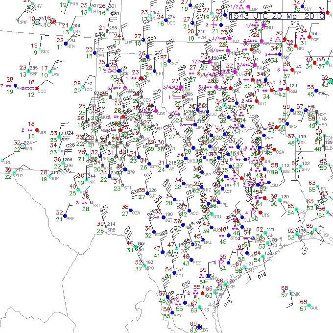
Posted: Sat Mar 20, 2010 11:01 am
by srainhoutx
Big spread in temps across TX this morning...
Re: March 2010- In Like A Lamb, Out Like A Lion?
Posted: Sat Mar 20, 2010 11:08 am
by txflagwaver
Folks to our South getting it pretty bad...60+mph winds and quarter size hail??? wow...
Re: March 2010- In Like A Lamb, Out Like A Lion?
Posted: Sat Mar 20, 2010 11:27 am
by wxdata
Dusting of snow in Amarillo where it's 22 at 11am (wow!)
Re: March 2010- In Like A Lamb, Out Like A Lion?
Posted: Sat Mar 20, 2010 12:00 pm
by wxdata
SPECIAL WEATHER STATEMENT
NATIONAL WEATHER SERVICE HOUSTON/GALVESTON TX
1158 AM CDT SAT MAR 20 2010
TXZ236>238-201800-
BRAZORIA-GALVESTON-MATAGORDA-
1158 AM CDT SAT MAR 20 2010
...SIGNIFICANT WEATHER ADVISORY...
AT 1148 AM CDT...NATIONAL WEATHER SERVICE DOPPLER RADAR INDICATED
STRONG THUNDERSTORMS ALONG A LINE EXTENDING FROM WEST COLUMBIA TO
MATAGORDA...MOVING EAST SOUTHEAST AT 30 MPH.
ONE HALF INCH DIAMETER HAIL...WINDS GREATER THAN 40 MPH...ARE
POSSIBLE WITH THESE STORMS.
LOCATIONS IN THE PATH OF THESE STORMS INCLUDE...SARGENT...
ROSHARON...GALVESTON STATE PARK...CHOCOLATE BAYOU...WEST COLUMBIA...
SWEENY...SURFSIDE BEACH...SANTA FE...RICHWOOD...QUINTANA...
LIVERPOOL...LAKE JACKSON...LA MARQUE...JAMAICA BEACH...HITCHCOCK...
FREEPORT...CLUTE...BONNEY...BAILEY'S PRAIRIE AND ANGLETON.
Re: March 2010- In Like A Lamb, Out Like A Lion?
Posted: Sat Mar 20, 2010 12:29 pm
by wxdata
Noticed that SPC took down the slight risk even for areas east of here for this afternoon.
Re: March 2010- In Like A Lamb, Out Like A Lion?
Posted: Sat Mar 20, 2010 1:59 pm
by sambucol
Are we out of danger for high winds and hail now?
Re: March 2010- In Like A Lamb, Out Like A Lion?
Posted: Sat Mar 20, 2010 3:55 pm
by wxdata
sambucol wrote:Are we out of danger for high winds and hail now?
From thunderstorms, yes. However:
URGENT - WEATHER MESSAGE
NATIONAL WEATHER SERVICE HOUSTON/GALVESTON TX
339 PM CDT SAT MAR 20 2010
...WIND ADVISORY IN EFFECT FOR THE SOUTHERN PORTIONS OF SOUTHEAST
TEXAS TONIGHT AND ALL OF SOUTHEAST TEXAS ON SUNDAY...
.STRONG NORTHWEST WINDS EXPECTED TO CONTINUE IN THE WAKE OF THE
COLD FRONT THAT PUSHED THROUGH EARLIER SATURDAY.
...WIND ADVISORY REMAINS IN EFFECT UNTIL 7 PM CDT SUNDAY...
WINDS MAY DIMINISH FOR A WHILE TONIGHT WELL INLAND BUT REMAIN
ELEVATED CLOSER TO THE COAST. EXPECT SUSTAINED NORTHWEST WINDS
BETWEEN 20 AND 30 MPH WITH HIGHER GUSTS TO PERSIST THROUGH SUNDAY.
Re: March 2010- In Like A Lamb, Out Like A Lion?
Posted: Sat Mar 20, 2010 7:17 pm
by Paul
just got back from West end...winds in the upper 20's gusting to low 30's....windchill down there about 37F...ugh....
Re: March 2010- In Like A Lamb, Out Like A Lion?
Posted: Sat Mar 20, 2010 11:19 pm
by sleetstorm
How do you decipher a storm system's intensity, wxman57, wxdata, srainhoutx, Ptarmigan, Mr. T? Are there certain numbers that indicate how strong and weak that it is?
Re: March 2010- In Like A Lamb, Out Like A Lion?
Posted: Sat Mar 20, 2010 11:59 pm
by C2G
Aunt called from Sanger (Just north of Denton.....which is north of Dallas Fort Worth) said they were getting snow again, big flakes.
She calls every time it snows up there now since our December 4th snow event.......just to rub it in, and she's rubbed it in a lot this winter.

For the love of everything decent in this world please bring on SPRING.
I truly HATE cold weather now.
Re: March 2010- In Like A Lamb, Out Like A Lion?
Posted: Sun Mar 21, 2010 12:46 am
by wxdata
Wind chill at IAH at midnight is only a nice chilly 31!
Re: March 2010- In Like A Lamb, Out Like A Lion?
Posted: Sun Mar 21, 2010 9:45 am
by Poltracker
It was still snowing in Dallas area this morning. Big problem was the wind and visibility. My brother reported almost 4 inches of snow in Rockwall. I was supposed to meet him and my sister in Buffalo this AM to give him a car (his got wrecked thanks to an unidentified 18 wheeler losing its wheel) but we had to cancel because the road conditions were so bad up there.
Re: March 2010- In Like A Lamb, Out Like A Lion?
Posted: Sun Mar 21, 2010 10:16 am
by wxman57
sleetstorm wrote:How do you decipher a storm system's intensity, wxman57, wxdata, srainhoutx, Ptarmigan, Mr. T? Are there certain numbers that indicate how strong and weak that it is?
First of all, are we all enjoying this first full day of spring? It's so nice to be done with all that cold, windy weather, isn't it? Anyone heading to the beach today to get some sun?
As for determining a storm's intensity, we look at its reflectivity in dBz. The more reflective, the stronger the storm. And we look at vertically integrated liquid (VIL) values. And we can look at Doppler velocity data to find evidence of rotation. The reflectivity and VIL values that determine severity do change a bit from season to season. Most modern radar programs help out with the determination with built-in algorithms to identify a severe storm by indicating rotation and hail size.
Re: March 2010- In Like A Lamb, Out Like A Lion?
Posted: Sun Mar 21, 2010 2:00 pm
by Ptarmigan
wxman57 wrote:
First of all, are we all enjoying this first full day of spring? It's so nice to be done with all that cold, windy weather, isn't it? Anyone heading to the beach today to get some sun?
As for determining a storm's intensity, we look at its reflectivity in dBz. The more reflective, the stronger the storm. And we look at vertically integrated liquid (VIL) values. And we can look at Doppler velocity data to find evidence of rotation. The reflectivity and VIL values that determine severity do change a bit from season to season. Most modern radar programs help out with the determination with built-in algorithms to identify a severe storm by indicating rotation and hail size.
It is too cold to go to the beach right now, you got me thinking.
Normally, it should be warm by now. I remember last year at this time, it was.
Re: March 2010- In Like A Lamb, Out Like A Lion?
Posted: Sun Mar 21, 2010 4:16 pm
by Katdaddy
The snow was great in Dallas and I am glad I got experience another snowfall. Driving out of Dallas was dangerous with the snow/slush covered bridges. Lots of wrecks. Glad to be home and very ready for real Spring.
Re: March 2010- In Like A Lamb, Out Like A Lion?
Posted: Sun Mar 21, 2010 4:26 pm
by sleetstorm
wxman57 wrote:sleetstorm wrote:How do you decipher a storm system's intensity, wxman57, wxdata, srainhoutx, Ptarmigan, Mr. T? Are there certain numbers that indicate how strong and weak that it is?
First of all, are we all enjoying this first full day of spring? It's so nice to be done with all that cold, windy weather, isn't it? Anyone heading to the beach today to get some sun?
As for determining a storm's intensity, we look at its reflectivity in dBz. The more reflective, the stronger the storm. And we look at vertically integrated liquid (VIL) values. And we can look at Doppler velocity data to find evidence of rotation. The reflectivity and VIL values that determine severity do change a bit from season to season. Most modern radar programs help out with the determination with built-in algorithms to identify a severe storm by indicating rotation and hail size.
What precisely/specifically is dBz?