Page 11 of 16
Re: March 2010- In Like A Lamb, Out Like A Lion?
Posted: Thu Mar 18, 2010 8:12 pm
by Ptarmigan
I have a feeling we could see freezing temperature into April.
Average Month To Last See 32 or Below
February
Median Month To Last See 32 or Below
February
Average Date To Last See 32 or Below
February 24
Median Date To Last See 32 or Below
February 27
Earliest Date To Last See 32 or Below
December 26, 1989 (Used -1 to represent December, since there was no 32 or below after the December 1989 Freeze.)
Latest Date To Last See 32 or Below
April 10, 1973
Re: March 2010- In Like A Lamb, Out Like A Lion?
Posted: Thu Mar 18, 2010 11:25 pm
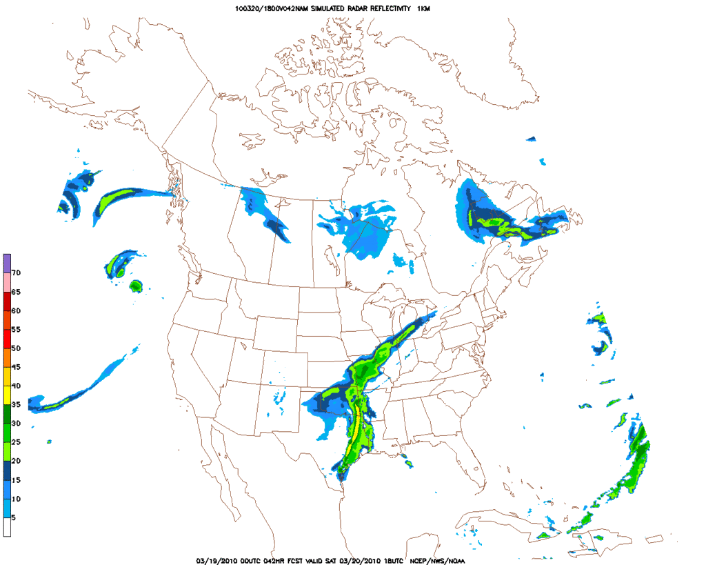
by srainhoutx
NAM suggests a healthy line of storms...
Re: March 2010- In Like A Lamb, Out Like A Lion?
Posted: Fri Mar 19, 2010 12:58 am
by wxdata
GFS: wrap around snow dives into east Texas early Sunday morning
Re: March 2010- In Like A Lamb, Out Like A Lion?
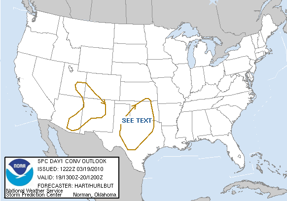
Posted: Fri Mar 19, 2010 1:39 am
by wxdata
SPC: marginal threat for severe weather here Saturday
"...CNTRL THROUGH SERN TX...
A BAND OF STORMS WILL BE ONGOING WITHIN ZONE OF FORCED ASCENT IN
VICINITY OF SEWD ADVANCING COLD FRONT. STORMS DEVELOPING ALONG SRN
END OF THIS BAND WILL EXIST WITHIN A STEEPER LAPSE RATE
ENVIRONMENT...
BUT INSTABILITY WILL REMAIN MARGINAL DUE TO LIMITED
LOW-LEVEL MOISTURE RETURN. SOME RISK FOR ISOLATED STRONG WIND GUSTS
AND HAIL WILL EXIST AS ACTIVITY DEVELOPS SEWD DURING THE DAY.
HOWEVER...OVERALL THREAT DOES NOT APPEAR SUFFICIENT TO WARRANT MORE
THAN 5% SEVERE PROBABILITIES."
Full forecast:
http://www.spc.noaa.gov/products/outloo ... 0_prt.html
Re: March 2010- In Like A Lamb, Out Like A Lion?
Posted: Fri Mar 19, 2010 7:39 am
by srainhoutx
DAY 1 CONVECTIVE OUTLOOK
NWS STORM PREDICTION CENTER NORMAN OK
0722 AM CDT FRI MAR 19 2010
VALID 191300Z - 201200Z
...NO SVR TSTM AREAS FORECAST...
...TX/OK...
A DEEP UPPER LOW/TROUGH IS SETTLING SOUTHEASTWARD ACROSS
CA/NV...WHILE A STRONG COLD FRONT DRIVES SOUTHWARD ACROSS THE
CENTRAL HIGH PLAINS THIS MORNING. INCREASING SOUTHERLY LOW LEVEL
WINDS AHEAD OF THE UPPER TROUGH WILL TRANSPORT ONLY MARGINALLY MOIST
AND UNSTABLE AIR NORTHWARD AHEAD OF THE FRONT...WITH ONLY LOW/MID
50S DEWPOINTS EXPECTED BY THIS EVENING OVER TX/OK.
NEVERTHELESS...RATHER STEEP LOW LEVEL LAPSE RATES AND COOL
TEMPERATURES ALOFT WILL PROVIDE THE INSTABILITY FOR A BAND OF LATE
AFTERNOON AND EVENING THUNDERSTORMS ALONG THE FRONT FROM CENTRAL OK
INTO WEST-CENTRAL TX. MODEL FORECAST SOUNDINGS IN THIS REGION
SUGGEST SUFFICIENT CAPE FOR THE RISK OF HAIL IN STRONGER
STORMS...MAINLY DURING THE FIRST 2-3 HOURS AFTER INITIATION. BEYOND
THAT TIME...STORMS WILL LIKELY MERGE INTO A PREDOMINANTLY NON-SEVERE
SQUALL LINE WHICH WILL SPREAD INTO NORTHERN AND CENTRAL PARTS OF TX.
..HART/HURLBUT.. 03/19/2010
Re: March 2010- In Like A Lamb, Out Like A Lion?
Posted: Fri Mar 19, 2010 9:21 am
by srainhoutx
12Z NAM suggests a rather strong line of storms along and ahead of the Cold Front tomorrow...doesn't look too boring wxdata...

Re: March 2010- In Like A Lamb, Out Like A Lion?
Posted: Fri Mar 19, 2010 11:16 am
by srainhoutx
Appears that we are going to make a run at some freezing morning lows in the Metro Area...
AREA FORECAST DISCUSSION
NATIONAL WEATHER SERVICE HOUSTON/GALVESTON TX
1044 AM CDT FRI MAR 19 2010
.UPDATE...
MORNING UPDATE BELOW.
&&
.DISCUSSION...
SURFACE HIGH PRESSURE WAS LOCATED OVER THE NORTHERN GULF COAST WITH
ONSHORE WINDS IN PLACE. WINDS WILL INCREASE IN SPEED THIS
AFTERNOON AS THE GRADIENT TIGHTENS. MORNING SOUNDINGS SUPPORT
CURRENT TEMP FORECAST. WILL TWEAK SKY COVER A BIT TO SHOW A SLIGHT
INCREASE IN AFTERNOON CLOUD COVER. MODELS SHOW A VERY COLD AIR
MASS ENTERING THE REGION SAT NIGHT INTO SUNDAY WITH 850 MB TEMPS
DROPPING TO BETWEEN -4 AND -8. IF THESE TEMPS VERIFY...FREEZING
TEMPS ARE POSSIBLE SUN OR MON MORNING. THINK WINDS ON SUNDAY WILL
BE STRONG ENOUGH AND MIXING WILL LIMIT A SUBFREEZING TEMPERATURE
DROP. 43
Re: March 2010- In Like A Lamb, Out Like A Lion?
Posted: Fri Mar 19, 2010 4:47 pm
by sleetstorm
Are these two freezes during Saturday night-Sunday morning and Sunday night-morning likey to be the last freezes that southeast Texas receives for this month or is another one predicted to come later on in this month and perhaps even one prior, during, or after Easter?
Re: March 2010- In Like A Lamb, Out Like A Lion?
Posted: Fri Mar 19, 2010 5:27 pm
by sleetstorm
How about this, southeast Texas gets an additional two cold waves for this weekend & for the initiation of the new work week, with the feasibility at getting two consecutive frosts or freezes. sigh

Hey, though frosts and freezes are not good for any fresh new leaves and flowers, all of us in this weather forum need to be truly thankful that it not predicted to be a hard freeze or even a very hard freeze, 20's or 10's for that would just be utterly horrible for any trees, shrubs, and small plants, excluding evergreens, setting them back x number of days if not weeks.

Or, do some of you not concur with this?
Re: March 2010- In Like A Lamb, Out Like A Lion?
Posted: Fri Mar 19, 2010 5:41 pm
by wxman57
It'll be hard to get to freezing Sunday morning with a low overcast that'll probably hang around until Sunday afternoon. With the upper low over NE TX, wrap around clouds will limit lows Saturday night and Sunday highs. May see upper 30s to 40 Sunday morning and a high closer to 50 than the upper 50s on Sunday with the clouds. Interesting that the Houston AFD says wrap around clouds most of Sunday but the zone forecast says clear to partly cloudy.
Re: March 2010- In Like A Lamb, Out Like A Lion?
Posted: Fri Mar 19, 2010 7:14 pm
by Katdaddy
WXman57 I am so ready for the real Spring. Up here in Dallas this weekend so I might get lucky and see more snow.
Re: March 2010- In Like A Lamb, Out Like A Lion?
Posted: Fri Mar 19, 2010 7:28 pm
by srainhoutx
Katdaddy wrote:WXman57 I am so ready for the real Spring. Up here in Dallas this weekend so I might get lucky and see more snow.
You and me both Katdaddy! Take some pics.
Re: March 2010- In Like A Lamb, Out Like A Lion?
Posted: Fri Mar 19, 2010 7:37 pm
by wxman57
Well, let's see if the 18Z GFS sees any spring on the horizon. Here are a couple of meteograms. As you can see, more days above 70, but nothing near 80 for the next 2 weeks. That's unbelievable, only a couple of 80 degree days through early April. And I do think Sunday will be overcast much of the day, so Monday should be the colder morning (35).


Re: March 2010- In Like A Lamb, Out Like A Lion?
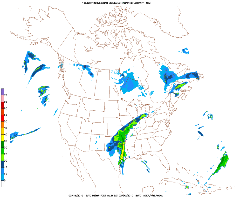
Posted: Fri Mar 19, 2010 9:44 pm
by wxdata
0z NAM showing track of upper low a bit further south than earlier runs.
Click map for larger image.
Re: March 2010- In Like A Lamb, Out Like A Lion?
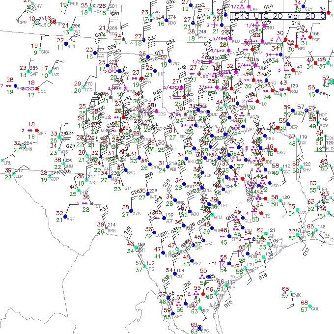
Posted: Sat Mar 20, 2010 11:01 am
by srainhoutx
Big spread in temps across TX this morning...
Re: March 2010- In Like A Lamb, Out Like A Lion?
Posted: Sat Mar 20, 2010 11:08 am
by txflagwaver
Folks to our South getting it pretty bad...60+mph winds and quarter size hail??? wow...
Re: March 2010- In Like A Lamb, Out Like A Lion?
Posted: Sat Mar 20, 2010 11:27 am
by wxdata
Dusting of snow in Amarillo where it's 22 at 11am (wow!)
Re: March 2010- In Like A Lamb, Out Like A Lion?
Posted: Sat Mar 20, 2010 12:00 pm
by wxdata
SPECIAL WEATHER STATEMENT
NATIONAL WEATHER SERVICE HOUSTON/GALVESTON TX
1158 AM CDT SAT MAR 20 2010
TXZ236>238-201800-
BRAZORIA-GALVESTON-MATAGORDA-
1158 AM CDT SAT MAR 20 2010
...SIGNIFICANT WEATHER ADVISORY...
AT 1148 AM CDT...NATIONAL WEATHER SERVICE DOPPLER RADAR INDICATED
STRONG THUNDERSTORMS ALONG A LINE EXTENDING FROM WEST COLUMBIA TO
MATAGORDA...MOVING EAST SOUTHEAST AT 30 MPH.
ONE HALF INCH DIAMETER HAIL...WINDS GREATER THAN 40 MPH...ARE
POSSIBLE WITH THESE STORMS.
LOCATIONS IN THE PATH OF THESE STORMS INCLUDE...SARGENT...
ROSHARON...GALVESTON STATE PARK...CHOCOLATE BAYOU...WEST COLUMBIA...
SWEENY...SURFSIDE BEACH...SANTA FE...RICHWOOD...QUINTANA...
LIVERPOOL...LAKE JACKSON...LA MARQUE...JAMAICA BEACH...HITCHCOCK...
FREEPORT...CLUTE...BONNEY...BAILEY'S PRAIRIE AND ANGLETON.
Re: March 2010- In Like A Lamb, Out Like A Lion?
Posted: Sat Mar 20, 2010 12:29 pm
by wxdata
Noticed that SPC took down the slight risk even for areas east of here for this afternoon.
Re: March 2010- In Like A Lamb, Out Like A Lion?
Posted: Sat Mar 20, 2010 1:59 pm
by sambucol
Are we out of danger for high winds and hail now?