Page 10 of 16
Re: March 2010- In Like A Lamb, Out Like A Lion?
Posted: Wed Mar 10, 2010 4:03 pm
by sleetstorm
What does the red line stand for and the violet line stand for on KHOU's radar?
Re: March 2010- In Like A Lamb, Out Like A Lion?
Posted: Wed Mar 10, 2010 6:07 pm
by txflagwaver
So I guess the rian is off for today?? Weird how when all the weatherfolk talk up a forecast it seems to go..ha ha...
Re: March 2010- In Like A Lamb, Out Like A Lion?
Posted: Wed Mar 10, 2010 9:04 pm
by sleetstorm
Ed Mahmoud wrote:sleetstorm wrote:What does the red line stand for and the violet line stand for on KHOU's radar?
No legend, but red seems to be severe t-storm and violet tornado warning.
NWS radars use yellow and red, which seems a more intuitive color code, plus they list a legend.
Those were my suppositions as well, Ed Mahmoud.
So much for getting any severe thunderstorms, huh?
Re: March 2010- In Like A Lamb, Out Like A Lion?
Posted: Wed Mar 10, 2010 9:05 pm
by weatherag
btw.....anyone checked out the new SPC mesoscale analysis page? Pretty sweet

Re: March 2010- In Like A Lamb, Out Like A Lion?
Posted: Wed Mar 10, 2010 11:53 pm
by sleetstorm
How did some of you get the degree symbol on this weather forum? Where did you go because I have been wanting to know that & employ it myself ever since I saw some of you wield it?
Re: March 2010- In Like A Lamb, Out Like A Lion?
Posted: Thu Mar 11, 2010 1:44 am
by wxdata
Easy. Type the number, then while holding down the ALT key, type 0176 on the KEYPAD (the regular numbers on the QWERTY keyboard won't do it.) Presto- a degree symbol.
80°
Re: March 2010- In Like A Lamb, Out Like A Lion?
Posted: Fri Mar 12, 2010 11:03 am
by srainhoutx
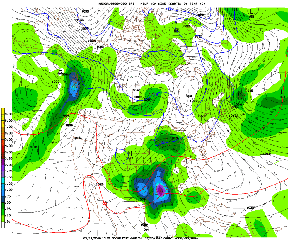
Longer range GFS continues to advertise what
may be the first significant severe weather threat of the season for SE TX...

Re: March 2010- In Like A Lamb, Out Like A Lion?
Posted: Sat Mar 13, 2010 8:32 am
by srainhoutx
The GFS continues to suggest a rather strong Spring storm and attending Cold Front near the 24th (+/- a day or so). It will be interesting to see if this storm system will bring the first bout of severe weather to the area.
Re: March 2010- In Like A Lamb, Out Like A Lion?
Posted: Sat Mar 13, 2010 8:50 am
by txflagwaver
And there is always the inevitable cold for Easter....
Re: March 2010- In Like A Lamb, Out Like A Lion?
Posted: Sat Mar 13, 2010 10:53 am
by wxdata
Ed Mahmoud wrote:txflagwaver wrote:And there is always the inevitable cold for Easter....
Didn't it snow on Easter in Waco a few years back? An Easter Miracle Snow here (I'd accept any time during the Paschal Triduum) would be final proof of Divine Love, wouldn't it.
It was one of those years when Easter fell in March.
Re: March 2010- In Like A Lamb, Out Like A Lion?
Posted: Sat Mar 13, 2010 10:54 am
by C2G
I'll consider a warm and cloudless day a sign of divine love on Easter.
Re: March 2010- In Like A Lamb, Out Like A Lion?
Posted: Sat Mar 13, 2010 11:17 am
by wxdata
srainhoutx wrote:Longer range GFS continues to advertise what may be the first significant severe weather threat of the season for SE TX...
Today's 12z GFS took even that threat away for SE TX. Boring..
Re: March 2010- In Like A Lamb, Out Like A Lion?
Posted: Sat Mar 13, 2010 3:16 pm
by wxdata
And strictly from the images above, the main 'action' stays north..
However, HPC still thinks temps stay below normal here for the next two weeks:
Re: March 2010- In Like A Lamb, Out Like A Lion?
Posted: Mon Mar 15, 2010 12:25 pm
by Ptarmigan
The storm in the Texas Panhandle is quite impressive. Very heavy rains. Doppler radar estimates that up to 4" per hour.
http://radar.weather.gov/Conus/southplains.php
Re: March 2010- In Like A Lamb, Out Like A Lion?
Posted: Tue Mar 16, 2010 12:34 am
by Ptarmigan
I notice on Doppler radar, there is rain west of here. Should be here later today.
Re: March 2010- In Like A Lamb, Out Like A Lion?
Posted: Tue Mar 16, 2010 8:59 am
by srainhoutx
From SPC. Looks like some elevated storms and a few rumbles possible today as the Cold Core Upper Low moves overhead...
...PORTIONS OF S-CENTRAL/SERN TX AND ADJACENT COASTAL PLAIN...
LARGE SCALE ASCENT IS FORECAST TO GRADUALLY WEAKEN DURING THE DAY AS
UPPER TROUGH APPROACHES THE GULF OF MEXICO. HOWEVER...A MID LEVEL
DRY SLOT DEPICTED IN MORNING WV IMAGERY IS BEING ENTRAINED INTO THE
UPPER CIRCULATION. AS A RESULT...POTENTIAL INSTABILITY MAY INCREASE
BENEATH AND IMMEDIATELY AHEAD OF THIS FEATURE DURING THE MID TO LATE
AFTERNOON...WITH MODIFIED 12Z DRT SOUNDING FOR A SURFACE TEMPERATURE
AROUND 60 AND DEWPOINTS HOLDING IN THE UPPER 40S/LOW 50S YIELDING
200-500 J/KG OF MUCAPE. IN ADDITION...A ZONE OF WEAK LOW LEVEL
CONFLUENCE IS FORECAST TO RESIDE ACROSS PORTIONS OF S-CENTRAL/SERN
TX AND THE ADJACENT COASTAL PLAIN...WHICH MAY ACT TO FOCUS THE
DEVELOPMENT OF A FEW THUNDERSTORMS.
Re: March 2010- In Like A Lamb, Out Like A Lion?
Posted: Wed Mar 17, 2010 8:47 am
by wxdata
Severe weather a possibility too!
Friday:
... PARTS OF NORTH CENTRAL/EASTERN TEXAS...
A SEPARATE AREA OF VIGOROUS CONVECTIVE DEVELOPMENT SEEMS POSSIBLE
ACROSS THE REGION PRIOR TO 12Z SATURDAY...WITHIN A STRENGTHENING
ELEVATED WARM ADVECTION REGIME...AS STRONGER MID/UPPER FORCING
FINALLY BEGINS TO SURGE EASTWARD ACROSS THE SOUTHERN PLAINS. THIS
MAY BE AIDED BY A SOMEWHAT BETTER INFLUX OF GULF MOISTURE ON THE
STRENGTHENING LOW-LEVEL JET...AND INSTABILITY COUPLED WITH
STRENGTHENING DEEP LAYER SHEAR MAY CONTRIBUTE TO A RISK FOR LARGE
HAIL.
Saturday:
GIVEN THE CLOSE PROXIMITY TO THE GULF
OF MEXICO...AND THE POTENTIAL STRENGTH OF LOW-LEVEL CYCLOGENESIS
ACCOMPANYING THE UPPER SYSTEM...MOISTURE RETURN TO A STRONGLY
SHEARED WARM SECTOR IS BECOMING A BIT LESS OF A CONCERN. THE
MAGNITUDE OF THE MOISTENING MAY NOT BE PARTICULARLY STRONG...BUT MID
50S+ F DEW POINTS PROBABLY WILL BE SUFFICIENT FOR A SIGNIFICANT
SEVERE THREAT...EVEN IF THE FORCING DOES NOT BECOME AS STRONG AS
CURRENTLY SUGGESTED BY THE 17/00Z ECMWF. CONSIDERABLE SPREAD STILL
EXISTS AMONG THE MODELS AND MODEL ENSEMBLES...BUT IF THIS ECMWF RUN
COMES CLOSE TO VERIFYING...THE SEVERE THREAT WILL PROBABLY INCLUDE
AT LEAST THE POSSIBILITY FOR ISOLATED STRONG TORNADOES.
Re: March 2010- In Like A Lamb, Out Like A Lion?
Posted: Wed Mar 17, 2010 8:59 am
by srainhoutx
wxdata wrote:Severe weather a possibility too!
Friday:
... PARTS OF NORTH CENTRAL/EASTERN TEXAS...
A SEPARATE AREA OF VIGOROUS CONVECTIVE DEVELOPMENT SEEMS POSSIBLE
ACROSS THE REGION PRIOR TO 12Z SATURDAY...WITHIN A STRENGTHENING
ELEVATED WARM ADVECTION REGIME...AS STRONGER MID/UPPER FORCING
FINALLY BEGINS TO SURGE EASTWARD ACROSS THE SOUTHERN PLAINS. THIS
MAY BE AIDED BY A SOMEWHAT BETTER INFLUX OF GULF MOISTURE ON THE
STRENGTHENING LOW-LEVEL JET...AND INSTABILITY COUPLED WITH
STRENGTHENING DEEP LAYER SHEAR MAY CONTRIBUTE TO A RISK FOR LARGE
HAIL.
Saturday:
GIVEN THE CLOSE PROXIMITY TO THE GULF
OF MEXICO...AND THE POTENTIAL STRENGTH OF LOW-LEVEL CYCLOGENESIS
ACCOMPANYING THE UPPER SYSTEM...MOISTURE RETURN TO A STRONGLY
SHEARED WARM SECTOR IS BECOMING A BIT LESS OF A CONCERN. THE
MAGNITUDE OF THE MOISTENING MAY NOT BE PARTICULARLY STRONG...BUT MID
50S+ F DEW POINTS PROBABLY WILL BE SUFFICIENT FOR A SIGNIFICANT
SEVERE THREAT...EVEN IF THE FORCING DOES NOT BECOME AS STRONG AS
CURRENTLY SUGGESTED BY THE 17/00Z ECMWF. CONSIDERABLE SPREAD STILL
EXISTS AMONG THE MODELS AND MODEL ENSEMBLES...BUT IF THIS ECMWF RUN
COMES CLOSE TO VERIFYING...THE SEVERE THREAT WILL PROBABLY INCLUDE
AT LEAST THE POSSIBILITY FOR ISOLATED STRONG TORNADOES.
Oh boy! Something non
boring to look
forward to and on a weekend.

Re: March 2010- In Like A Lamb, Out Like A Lion?
Posted: Wed Mar 17, 2010 12:45 pm
by srainhoutx
Some thoughts from Jeff concerning the weekend...
Strong cold air outbreak headed for TX this weekend.
Potential for frost/freeze across portions of SE /SC TX Sunday and Monday mornings.
Upper level storm system responsible for the rains yesterday has pushed east of the area. Water vapor images show a strong vort over the Midwest dropping southward on the backside of this system however with very limited moisture only an increase in clouds can be expected late this afternoon as this system drops down the Sabine River.
Very nice weather in store for the region Thursday and Friday with lows in the 40’s and highs in the low to mid 70’s under mostly sunny skies and increasing southerly winds.
Next item of interest is a strong storm system/cold front combo on Saturday. Models continue to come in deeper and colder with this system with a good cold push out of NW Canada as a strong ridge develops along the US west coast with a deep downstream eastern US trough. Moisture return begins in earnest on Friday as pressures lower over the TX panhandle. Do not expect showers until sometime Saturday morning. Cold front plows southward Saturday reaching the area around midday and sweeping off the coast by late afternoon. While moisture return looks marginal there should be enough to squeeze out a round of showers and thunderstorms along the front. SPC has already highlighted our eastern counties for a risk of a few severe storms…but this looks highly marginal. A good temperature drop and increase in NW winds will make Saturday afternoon feel like we are back in deep winter again with temps. Falling through the 50’s into the upper 40’s under NW winds of 15-25 mph.
Bigger concern is how cold will it get as spring green up is well underway and sensitive plantings could be damaged by a frost/freeze. Current guidance suggest near freezing temperatures across the northern portion of SE TX then SW toward the northern coastal bend by Sunday morning as cold air advection brings near 0C 850mb temperatures southward. 540mb thickness values support some fairly chilly air for Sunday. Will go with a light freeze north of Hwy 105 Sunday morning and in the rural areas along and west of a line from Cypress to Katy to Richmond. Bigger concern for a more widespread freeze/frost will come Monday morning under clear skies and light winds. Models are showing weak return flow by early Monday morning and dewpoint recovery to above freezing however if this is delayed by a few hours several locations could bottom out in the 30-34 degree range especially along and NE of a line from Bay City to Wharton to Giddings.
Re: March 2010- In Like A Lamb, Out Like A Lion?
Posted: Wed Mar 17, 2010 10:42 pm
by vbhoutex
Sounds nice till Saturday, then BBRRRR!!!!

Spring is supposed to be here!!
