
March 2010- In Like A Lamb, Out Like A Lion?

I'll consider a warm and cloudless day a sign of divine love on Easter.

Today's 12z GFS took even that threat away for SE TX. Boring..srainhoutx wrote:Longer range GFS continues to advertise what may be the first significant severe weather threat of the season for SE TX...
And strictly from the images above, the main 'action' stays north..
However, HPC still thinks temps stay below normal here for the next two weeks:
However, HPC still thinks temps stay below normal here for the next two weeks:


The storm in the Texas Panhandle is quite impressive. Very heavy rains. Doppler radar estimates that up to 4" per hour.
http://radar.weather.gov/Conus/southplains.php
http://radar.weather.gov/Conus/southplains.php
I notice on Doppler radar, there is rain west of here. Should be here later today.
-
srainhoutx

- Site Admin

- Posts: 19616
- Joined: Tue Feb 02, 2010 2:32 pm
- Location: Maggie Valley, NC
- Contact:
From SPC. Looks like some elevated storms and a few rumbles possible today as the Cold Core Upper Low moves overhead...
...PORTIONS OF S-CENTRAL/SERN TX AND ADJACENT COASTAL PLAIN...
LARGE SCALE ASCENT IS FORECAST TO GRADUALLY WEAKEN DURING THE DAY AS
UPPER TROUGH APPROACHES THE GULF OF MEXICO. HOWEVER...A MID LEVEL
DRY SLOT DEPICTED IN MORNING WV IMAGERY IS BEING ENTRAINED INTO THE
UPPER CIRCULATION. AS A RESULT...POTENTIAL INSTABILITY MAY INCREASE
BENEATH AND IMMEDIATELY AHEAD OF THIS FEATURE DURING THE MID TO LATE
AFTERNOON...WITH MODIFIED 12Z DRT SOUNDING FOR A SURFACE TEMPERATURE
AROUND 60 AND DEWPOINTS HOLDING IN THE UPPER 40S/LOW 50S YIELDING
200-500 J/KG OF MUCAPE. IN ADDITION...A ZONE OF WEAK LOW LEVEL
CONFLUENCE IS FORECAST TO RESIDE ACROSS PORTIONS OF S-CENTRAL/SERN
TX AND THE ADJACENT COASTAL PLAIN...WHICH MAY ACT TO FOCUS THE
DEVELOPMENT OF A FEW THUNDERSTORMS.
Carla/Alicia/Jerry(In The Eye)/Michelle/Charley/Ivan/Dennis/Katrina/Rita/Wilma/Humberto/Ike/Harvey
Member: National Weather Association
Facebook.com/Weather Infinity
Twitter @WeatherInfinity
Member: National Weather Association
Facebook.com/Weather Infinity
Twitter @WeatherInfinity
Severe weather a possibility too!
Friday:
... PARTS OF NORTH CENTRAL/EASTERN TEXAS...
A SEPARATE AREA OF VIGOROUS CONVECTIVE DEVELOPMENT SEEMS POSSIBLE
ACROSS THE REGION PRIOR TO 12Z SATURDAY...WITHIN A STRENGTHENING
ELEVATED WARM ADVECTION REGIME...AS STRONGER MID/UPPER FORCING
FINALLY BEGINS TO SURGE EASTWARD ACROSS THE SOUTHERN PLAINS. THIS
MAY BE AIDED BY A SOMEWHAT BETTER INFLUX OF GULF MOISTURE ON THE
STRENGTHENING LOW-LEVEL JET...AND INSTABILITY COUPLED WITH
STRENGTHENING DEEP LAYER SHEAR MAY CONTRIBUTE TO A RISK FOR LARGE
HAIL.
Saturday:
GIVEN THE CLOSE PROXIMITY TO THE GULF
OF MEXICO...AND THE POTENTIAL STRENGTH OF LOW-LEVEL CYCLOGENESIS
ACCOMPANYING THE UPPER SYSTEM...MOISTURE RETURN TO A STRONGLY
SHEARED WARM SECTOR IS BECOMING A BIT LESS OF A CONCERN. THE
MAGNITUDE OF THE MOISTENING MAY NOT BE PARTICULARLY STRONG...BUT MID
50S+ F DEW POINTS PROBABLY WILL BE SUFFICIENT FOR A SIGNIFICANT
SEVERE THREAT...EVEN IF THE FORCING DOES NOT BECOME AS STRONG AS
CURRENTLY SUGGESTED BY THE 17/00Z ECMWF. CONSIDERABLE SPREAD STILL
EXISTS AMONG THE MODELS AND MODEL ENSEMBLES...BUT IF THIS ECMWF RUN
COMES CLOSE TO VERIFYING...THE SEVERE THREAT WILL PROBABLY INCLUDE
AT LEAST THE POSSIBILITY FOR ISOLATED STRONG TORNADOES.
-
srainhoutx
- Site Admin
- Posts: 19616
- Joined: Tue Feb 02, 2010 2:32 pm
- Location: Maggie Valley, NC
- Contact:
Oh boy! Something non boring to look forward to and on a weekend.wxdata wrote:Severe weather a possibility too!
Friday:
... PARTS OF NORTH CENTRAL/EASTERN TEXAS...
A SEPARATE AREA OF VIGOROUS CONVECTIVE DEVELOPMENT SEEMS POSSIBLE
ACROSS THE REGION PRIOR TO 12Z SATURDAY...WITHIN A STRENGTHENING
ELEVATED WARM ADVECTION REGIME...AS STRONGER MID/UPPER FORCING
FINALLY BEGINS TO SURGE EASTWARD ACROSS THE SOUTHERN PLAINS. THIS
MAY BE AIDED BY A SOMEWHAT BETTER INFLUX OF GULF MOISTURE ON THE
STRENGTHENING LOW-LEVEL JET...AND INSTABILITY COUPLED WITH
STRENGTHENING DEEP LAYER SHEAR MAY CONTRIBUTE TO A RISK FOR LARGE
HAIL.
Saturday:
GIVEN THE CLOSE PROXIMITY TO THE GULF
OF MEXICO...AND THE POTENTIAL STRENGTH OF LOW-LEVEL CYCLOGENESIS
ACCOMPANYING THE UPPER SYSTEM...MOISTURE RETURN TO A STRONGLY
SHEARED WARM SECTOR IS BECOMING A BIT LESS OF A CONCERN. THE
MAGNITUDE OF THE MOISTENING MAY NOT BE PARTICULARLY STRONG...BUT MID
50S+ F DEW POINTS PROBABLY WILL BE SUFFICIENT FOR A SIGNIFICANT
SEVERE THREAT...EVEN IF THE FORCING DOES NOT BECOME AS STRONG AS
CURRENTLY SUGGESTED BY THE 17/00Z ECMWF. CONSIDERABLE SPREAD STILL
EXISTS AMONG THE MODELS AND MODEL ENSEMBLES...BUT IF THIS ECMWF RUN
COMES CLOSE TO VERIFYING...THE SEVERE THREAT WILL PROBABLY INCLUDE
AT LEAST THE POSSIBILITY FOR ISOLATED STRONG TORNADOES.
Carla/Alicia/Jerry(In The Eye)/Michelle/Charley/Ivan/Dennis/Katrina/Rita/Wilma/Humberto/Ike/Harvey
Member: National Weather Association
Facebook.com/Weather Infinity
Twitter @WeatherInfinity
Member: National Weather Association
Facebook.com/Weather Infinity
Twitter @WeatherInfinity
-
srainhoutx
- Site Admin
- Posts: 19616
- Joined: Tue Feb 02, 2010 2:32 pm
- Location: Maggie Valley, NC
- Contact:
Some thoughts from Jeff concerning the weekend...
Strong cold air outbreak headed for TX this weekend.
Potential for frost/freeze across portions of SE /SC TX Sunday and Monday mornings.
Upper level storm system responsible for the rains yesterday has pushed east of the area. Water vapor images show a strong vort over the Midwest dropping southward on the backside of this system however with very limited moisture only an increase in clouds can be expected late this afternoon as this system drops down the Sabine River.
Very nice weather in store for the region Thursday and Friday with lows in the 40’s and highs in the low to mid 70’s under mostly sunny skies and increasing southerly winds.
Next item of interest is a strong storm system/cold front combo on Saturday. Models continue to come in deeper and colder with this system with a good cold push out of NW Canada as a strong ridge develops along the US west coast with a deep downstream eastern US trough. Moisture return begins in earnest on Friday as pressures lower over the TX panhandle. Do not expect showers until sometime Saturday morning. Cold front plows southward Saturday reaching the area around midday and sweeping off the coast by late afternoon. While moisture return looks marginal there should be enough to squeeze out a round of showers and thunderstorms along the front. SPC has already highlighted our eastern counties for a risk of a few severe storms…but this looks highly marginal. A good temperature drop and increase in NW winds will make Saturday afternoon feel like we are back in deep winter again with temps. Falling through the 50’s into the upper 40’s under NW winds of 15-25 mph.
Bigger concern is how cold will it get as spring green up is well underway and sensitive plantings could be damaged by a frost/freeze. Current guidance suggest near freezing temperatures across the northern portion of SE TX then SW toward the northern coastal bend by Sunday morning as cold air advection brings near 0C 850mb temperatures southward. 540mb thickness values support some fairly chilly air for Sunday. Will go with a light freeze north of Hwy 105 Sunday morning and in the rural areas along and west of a line from Cypress to Katy to Richmond. Bigger concern for a more widespread freeze/frost will come Monday morning under clear skies and light winds. Models are showing weak return flow by early Monday morning and dewpoint recovery to above freezing however if this is delayed by a few hours several locations could bottom out in the 30-34 degree range especially along and NE of a line from Bay City to Wharton to Giddings.
Carla/Alicia/Jerry(In The Eye)/Michelle/Charley/Ivan/Dennis/Katrina/Rita/Wilma/Humberto/Ike/Harvey
Member: National Weather Association
Facebook.com/Weather Infinity
Twitter @WeatherInfinity
Member: National Weather Association
Facebook.com/Weather Infinity
Twitter @WeatherInfinity
Sounds nice till Saturday, then BBRRRR!!!!  Spring is supposed to be here!!
Saturday looking a little more interesting (especially north and east of Houston:)
"GIVEN THE COLD NATURE OF THE MID-LEVEL SYSTEM...THE STRONG FORCING...AND
STRENGTHENING VERTICAL SHEAR IN THE WARM SECTOR...INCLUDING
ENLARGING CLOCKWISE CURVED LOW-LEVEL HODOGRAPHS...SEVERE STORMS ARE
POSSIBLE DURING THIS PERIOD. HIGHEST PROBABILITIES SEEM TO EXISTS
ACROSS PARTS OF CENTRAL LOUISIANA AND CENTRAL/SOUTHERN MISSISSIPPI
INTO WEST CENTRAL ALABAMA SATURDAY NIGHT. IF OTHER MODELS BEGIN TO
TREND TOWARD THE CURRENT SLOWER/MORE SOUTHERN ECMWF...SEVERE
POTENTIAL MAY BE HIGHER THAN CURRENTLY INDICATED...INCLUDING THE
RISK FOR ISOLATED STRONG TORNADOES."
Thursday morning email from jeff:
Nice weather today and Friday will end Saturday as a strong late season cold front brings an impressive cold snap for mid March.
Potential for frost/light freeze on Sunday morning and Monday morning for portions of the area.
High pressure will begin to move eastward today allowing the development of onshore winds by tonight. Gulf of Mexico is highly worked over from the past storm system with little moisture to be found. SE winds will increase on Friday with dewpoints recovering into the 50’s by Friday evening. Potent upper level storm will drop through the Rockies and into late Friday into Saturday while cold air over NW Canada surges southward down the plains. Moisture return ahead of this feature will be fairly modest with only upper 50 degree dewpoints expected by early Saturday. ECMWF is slower and deeper with the trough and provides a much better shot at showers and thunderstorms. However will side toward the faster GFS with a dense cold air mass likely pushing southward faster than guidance would tend to show. Additionally, systems of late have had a tough time producing wetting rains over TX with poor quality moisture return off a rather cold Gulf of Mexico.
Dynamics will be impressive with this system and if better quality moisture can be drawn northern then a severe weather threat would be possible mainly along and east of I-45. Feel most areas will see some rainfall with this event given strong frontal forcing…with the greatest coverage E of I-45 and the least coverage toward Matagorda Bay. Very strong offshore flow develops behind the front with 40-50kts around 850mb for Saturday afternoon and temperatures dropping into the lower 50’s.Expect sustained 15-25mph winds at the surface making for a very blustery first day of spring.
Big question is how cold for Sunday and Monday mornings. Feel winds will stay up some overnight Saturday and this may help save some areas from a freeze. With that said lows of 32-35 will be possible from roughly Columbus to Conroe to Livingston Sunday morning. Past studies suggest the second night behind the front is usually the coldest and this seems likely with this event with clear skies, light winds, and surface ridge nearly overhead. Guidance continues to come in warmer for Monday morning, but I like a colder solution given the above reasoning. Will go with a light freeze and heavy frost (given small T/Td depressions) for areas along and N of a line from Victoria to Wharton to Sugar Land to Cypress to Kingwood to Liberty. Only a few hours of near or at freezing, but with the spring planting and green up season underway some significant damage is possible. It is still possible that the surface ridge will translate across the region during the overnight hours Sunday into Monday morning allowing weak onshore flow to develop and a slight enough increase in dewpoints to keep more of the SW and W counties a tad warmer…I think this is what the models are hinting at with their warmer lows for Monday.
-
srainhoutx
- Site Admin
- Posts: 19616
- Joined: Tue Feb 02, 2010 2:32 pm
- Location: Maggie Valley, NC
- Contact:
Tomorrow looks to offer some storms in Central and Northeast TX as the potent cold front makes it's approach....
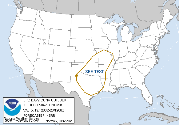
DAY 2 CONVECTIVE OUTLOOK
NWS STORM PREDICTION CENTER NORMAN OK
1204 AM CDT THU MAR 18 2010
VALID 191200Z - 201200Z
...NO SVR TSTM AREAS FORECAST...
...SYNOPSIS...
ONE VIGOROUS SHORT WAVE TROUGH LIFTING TOWARD THE BRITISH COLUMBIA
COAST...AND ANOTHER DIGGING OUT OF THE CANADIAN NORTHWEST
TERRITORIES...COULD BEGIN TO WEAKEN SHARP RIDGING ALONG THE PACIFIC
COAST. HOWEVER...MODELS CONTINUE TO INDICATE THAT THIS AMPLIFIED
REGIME WILL REMAIN STRONG THROUGH AT LEAST MUCH OF THIS FORECAST
PERIOD. AND A STRONG DOWNSTREAM SHORT WAVE TROUGH APPEARS LIKELY TO
DIG SOUTH SOUTHEASTWARD OR SOUTHWARD ACROSS THE CENTRAL ROCKIES INTO
THE SOUTHERN HIGH PLAINS BY 12Z SATURDAY. THIS IS EXPECTED TO BE
ACCOMPANIED BY A SIGNIFICANT COLD INTRUSION TO THE LEE THE
ROCKIES...THE LEADING EDGE OF WHICH MAY PROVIDE THE FOCUS FOR ONE OR
MORE SURFACE FRONTAL WAVES.
MODELS APPEAR TO BE TRENDING A BIT WEAKER WITH THE WAVE DEVELOPMENT
AND FASTER WITH THE COLD FRONT INTO AND THROUGH THE SOUTHERN PLAINS
FRIDAY. BUT...A BELT OF MODESTLY STRONG SOUTHERLY LOW-LEVEL FLOW
STILL SEEMS LIKELY TO DEVELOP OFF THE GULF OF MEXICO THROUGH MUCH OF
THE CENTRAL/SOUTHERN PLAINS AND LOWER HALF OF THE MISSISSIPPI
VALLEY. HOWEVER...IN THE WAKE OF RECENT DRYING...SUBSTANTIVE
BOUNDARY LAYER MOISTENING OVER THE GULF OF MEXICO WILL BE SLOW TO
OCCUR. WHILE THE LATEST SREF GUIDANCE SEEMS TO SUGGEST THAT THIS
MAY PROCEED A BIT MORE RAPIDLY THAN EARLIER ANTICIPATED...IT STILL
APPEARS PROBABLE THAT MID 50S SURFACE DEW POINTS WILL NOT ADVECT
MUCH FARTHER NORTH THAN THE TEXAS COASTAL PLAINS BY THE END OF THE
PERIOD. THIS WILL LIMIT THE CONVECTIVE POTENTIAL...BUT THE RISK FOR
THUNDERSTORM ACTIVITY SHOULD INCREASE ACROSS THE SOUTH CENTRAL
STATES BY FRIDAY EVENING...AND PROBABILITIES FOR SEVERE STORMS MAY
NOT BE COMPLETELY NEGLIGIBLE.
...SOUTH CENTRAL PLAINS...
A NARROW PRE-FRONTAL CORRIDOR OF STRONGER SURFACE HEATING... BENEATH
AN ELEVATED MIXED LAYER ADVECTING NORTHEASTWARD FROM THE TEXAS SOUTH
PLAINS THROUGH WESTERN/CENTRAL OKLAHOMA...IS STILL EXPECTED TO
CONTRIBUTE TO AN AXIS OF WEAK CONDITIONAL AND CONVECTIVE INSTABILITY
BY LATE FRIDAY AFTERNOON. EVEN WITH PRIMARY MID-LEVEL COOLING/LIFT
STILL LAGGING TO THE NORTH AND WEST...WEAK LOW-LEVEL MOISTENING AND
FRONTAL FORCING PROBABLY WILL CONTRIBUTE TO THE INITIATION OF STORMS
PRIOR TO 20/00Z. IN THE PRESENCE OF MODEST SHEAR...MARGINALLY
SEVERE HAIL MAY NOT BE OUT OF THE QUESTION. BUT...POTENTIALLY
DAMAGING WIND GUSTS ARE THE PRIMARY SEVERE CONCERN...AS SIZABLE
LOWER/MID TROPOSPHERIC TEMPERATURE/DEW POINT SPREADS ENHANCE
EVAPORATIVE COOLING IN DOWNDRAFTS WITHIN AN EVOLVING NARROW SQUALL
LINE. THIS THREAT MAY CONTINUE EASTWARD ACROSS PARTS OF
CENTRAL/EASTERN OKLAHOMA AND NORTH CENTRAL TEXAS...BEFORE
DIMINISHING DURING THE EVENING AS THE FRONT UNDERCUTS CONVECTION AND
MOISTURE RETURN.
...PARTS OF CENTRAL/NORTHEAST TEXAS...
A SEPARATE AREA OF VIGOROUS CONVECTIVE DEVELOPMENT STILL SEEMS
POSSIBLE PRIOR TO 12Z SATURDAY...WITHIN A STRENGTHENING ELEVATED
WARM ADVECTION REGIME...AS STRONGER MID/UPPER FORCING FINALLY BEGINS
TO SURGE EASTWARD INTO THE SOUTHERN PLAINS. THIS MAY BE AIDED BY A
SOMEWHAT STRONGER INFLUX OF GULF MOISTURE ON THE STRENGTHENING
SOUTHERLY LOW-LEVEL JET. INCREASING INSTABILITY COUPLED WITH
STRENGTHENING DEEP LAYER SHEAR COULD CONTRIBUTE TO A RISK FOR LARGE
HAIL.
..KERR.. 03/18/2010
Carla/Alicia/Jerry(In The Eye)/Michelle/Charley/Ivan/Dennis/Katrina/Rita/Wilma/Humberto/Ike/Harvey
Member: National Weather Association
Facebook.com/Weather Infinity
Twitter @WeatherInfinity
Member: National Weather Association
Facebook.com/Weather Infinity
Twitter @WeatherInfinity
-
srainhoutx
- Site Admin
- Posts: 19616
- Joined: Tue Feb 02, 2010 2:32 pm
- Location: Maggie Valley, NC
- Contact:
HPC QPF disco also suggests this late winter storm will be rather potent and will cause many problems fom wintry weather to heavy convective rains as it organizes...
DAYS 2 AND 3...
ROCKIES INTO CNTRL CONUS...
QUITE A WET AND POWERFUL SYSTEM WILL EVOLVE ON FRI AND SAT ACROSS
THE SRN PLAINS INTO THE MID TO LWR MS VLY. A POTENT SRN STREAM
SHORT WAVE PLOWING THROUGH THE FOUR CORNERS REGION WILL EJECT OUT
OF THE WRN TERRAIN INTO THE SRN PLAINS AND DEEPEN RAPIDLY. THIS
SYSTEM WILL QUICKLY CLOSE OFF A MID TO UPPER LOW AND GRADUALLY
BECOME DETACHED FROM THE OVERALL STEERING CURRENT. THIS IS DUE
INITIALLY TO THE SPLIT NATURE OF THE UPPER TROUGH EARLY ON FRI...
WITH THE NRN STREAM EXTENT REMAINING VERY FLAT OVER THE UPR MS VLY
AND PRETTY MUCH BEING A NON-FACTOR AS IT PROGRESSES DOWNSTREAM...
EXCEPT FOR DIRECTING A VERY DECENT THERMAL BOUNDARY/COLD FRONT
DOWN THE FRONT RANGE OF THE ROCKIES AND THROUGH THE PLAINS. THE
OTHER PROBLEM WITH THE SPLIT FLOW AND SRN STREAM BECOMING DOMINANT
IS LARGE SPREAD WITH THE FCST GUIDANCE FURTHER AND FURTHER OUT IN
TIME. INITIALLY... THE 00Z GFS/ECMWF ARE IN ENOUGH AGREEMENT ON
FRI/D2 THAT HPC FOLLOWED A BLEND OF THE TWO FOR MOST FACETS OF
THIS SYSTEM INCLUDING QPF. EXPECT TWO SIGNIFICANT POCKETS FOR
QPF... ONE BACK OVER CO INTO NM OR BASICALLY A COMBO OF UPSLOPE
FLOW AND STRONG DYNAMIC FORCING WITH THE UPPER VORT AND A SECOND
AREA EXPANDING FROM IA SWWRD THROUGH THE CENTRAL PLAINS INTO THE
SRN PLAINS OR A COMBO OF A WEAK VORT SLIDING FROM NE TO THE GRT
LAKES AND MOISTURE FROM THE GULF BEGINNING TO OVERRUN THE FRONTAL
BOUNDARY INTO THE COLD SECTOR. THEN ON SAT/D3... LARGE MODEL
SPREAD EXISTS BUT AN OVERALL TREND IS BEGINNING TO TAKE FORM... A
LARGE CLOSED LOW FORMING AND REALLY SLOWING DOWN. THUS HPC
FOLLOWED THE 00Z ECMWF AS A BASE AND ADDED A SMALL PORTION OF THE
GFS... THE OTHER GUIDANCE IS TOO PROGRESSIVE AND THE 03Z SREF MEAN
SUPPORTS THE SLOWER TREND. EXPECT A MASSIVE SURGE OF DEEP GULF OF
MEXICO MOISTURE TO SPREAD NORTH INTERACT WITH THE LARGE BECOMING
STACKED AREA OF LOW PRESSURE AND A MASSIVE RAIN/CONVECTION AND
POTENTIAL SNOW EVENT FROM OK/ERN TX AND SERN KS NEWRD THROUGH THE
MID TO LWR MS VLY.
Carla/Alicia/Jerry(In The Eye)/Michelle/Charley/Ivan/Dennis/Katrina/Rita/Wilma/Humberto/Ike/Harvey
Member: National Weather Association
Facebook.com/Weather Infinity
Twitter @WeatherInfinity
Member: National Weather Association
Facebook.com/Weather Infinity
Twitter @WeatherInfinity
-
srainhoutx
- Site Admin
- Posts: 19616
- Joined: Tue Feb 02, 2010 2:32 pm
- Location: Maggie Valley, NC
- Contact:
If the 12Z NAM is correct, there appears to be a good shot at some stronger storms as the cold front heads into our area...
http://www.nco.ncep.noaa.gov/pmb/nwprod ... loop.shtml
http://www.nco.ncep.noaa.gov/pmb/nwprod ... loop.shtml
Carla/Alicia/Jerry(In The Eye)/Michelle/Charley/Ivan/Dennis/Katrina/Rita/Wilma/Humberto/Ike/Harvey
Member: National Weather Association
Facebook.com/Weather Infinity
Twitter @WeatherInfinity
Member: National Weather Association
Facebook.com/Weather Infinity
Twitter @WeatherInfinity
-
srainhoutx
- Site Admin
- Posts: 19616
- Joined: Tue Feb 02, 2010 2:32 pm
- Location: Maggie Valley, NC
- Contact:
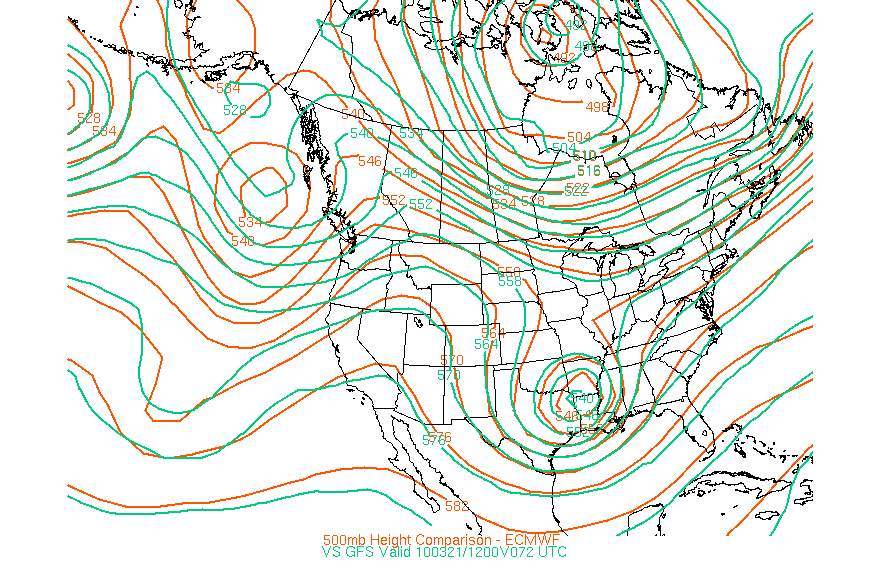
Rather good agreement in regard to the 12Z GFS and ECMWF as well as the NAM of a rather potent closed off low and colder weather as we head toward Saturday afternoon and the remainder of the weekend…
Carla/Alicia/Jerry(In The Eye)/Michelle/Charley/Ivan/Dennis/Katrina/Rita/Wilma/Humberto/Ike/Harvey
Member: National Weather Association
Facebook.com/Weather Infinity
Twitter @WeatherInfinity
Member: National Weather Association
Facebook.com/Weather Infinity
Twitter @WeatherInfinity
-
wxman57

- Global Moderator

- Posts: 2621
- Joined: Thu Feb 04, 2010 5:34 am
- Location: Southwest Houston (Westbury)
- Contact:
Good agreement through this weekend, but look off the Pacific NW coast. Quite a difference between what the GFS has moving ashore vs. the Euro. That may mean that the GFS is way off on next week's forecast (assuming the EC is correct).srainhoutx wrote:Rather good agreement in regard to the 12Z GFS and ECMWF as well as the NAM of a rather potent closed off low and colder weather as we head toward Saturday afternoon and the remainder of the weekend…
http://i228.photobucket.com/albums/ee29 ... 00cf72.gif
12z NAM at 4pm Saturday.
12z Bufkit data shows IAH not very unstable on Saturday; NAM a bit more unstable.
Hazardous Outlook from HGX:
"ON SATURDAY...A COLD FRONT WILL CROSS SOUTHEAST TEXAS. FAVORABLE
UPPER LEVEL WINDS COUPLED WITH THE FRONT WILL SET THE STAGE FOR
NUMEROUS SHOWERS AND THUNDERSTORMS ON SATURDAY. A FEW OF THE
STORMS COULD BE STRONG TO SEVERE WITH LARGE HAIL AND DAMAGING
WINDS. THE BEST CHANCE FOR SEVERE WEATHER OCCUR BETWEEN 11 AM AND
6 PM AND GENERALLY EAST OF THE I-45 CORRIDOR.