
March 2010- In Like A Lamb, Out Like A Lion?
-
sleetstorm
- Posts: 651
- Joined: Thu Feb 04, 2010 12:33 pm
- Contact:
Have any of you ever been in an Derecho, Bow Echo, Hook thunderstorm, & Supercell thunderstorm in the past? I know that this is off topic but I am just inquistive to read about your thoughts and stories.


I have been through a bow echo before. Lots of wind and rain. Kinda feels like you are in a hurricane.sleetstorm wrote:Have any of you ever been in an Derecho, Bow Echo, Hook thunderstorm, & Supercell thunderstorm in the past? I know that this is off topic but I am just inquistive to read about your thoughts and stories.


dbz is the amount of transmitted energy returned back to the radar with the values increasing along with the amount of reflectivity energy. For example, a thunderstorm containing hail will give much larger dbz (aka reflectivity) values than just a light shower because the hail stones will be able to reflect more energy than just light rain.sleetstorm wrote:What precisely/specifically is dBz?
-
wxman57

- Global Moderator

- Posts: 2621
- Joined: Thu Feb 04, 2010 5:34 am
- Location: Southwest Houston (Westbury)
- Contact:
This explains it, though it's technical. And the numbers the author identifies to distinguish light from heavy rain/strong storms looks to be "northern" numbers. Down south, we typically see much higher dbZ values, particularly in the warmer months.sleetstorm wrote: What precisely/specifically is dBz?
http://en.wikipedia.org/wiki/DBZ_%28meteorology%29
-
srainhoutx

- Site Admin

- Posts: 19616
- Joined: Tue Feb 02, 2010 2:32 pm
- Location: Maggie Valley, NC
- Contact:
I hope we are now done with this crazy winter pattern that brought many new records across TX with a -AO, -NAO, +PNA and blocking that was relentless since December. Bring on the warmth! 
http://www.star-telegram.com/2010/03/21 ... z0iubHSXisIt's official: North Texas had one of the snowiest winter seasons on record.
The National Weather Service in Fort Worth reported today that North Texas got 17.1 inches of snow this cold season, ranking it No. 2 behind the 1977-78 season which got 17.6 inches.
Of course, this weekend's dusting of snow helped the 2009-10 total. Dallas/Fort Worth Airport recorded 1.2 inches of snow on Saturday, which shattered the old record of 0.4 inches established on March 20, 1970. An additional 0.1 inches of snow earlier today brought the weekend total to 1.3 inches.
Yes, spring did arrive on Saturday, but meteorologist Dan Shoemaker said today that the NWS observations are not based on the calendar, but on the more loosely defined season.
So if North Texas gets snow in the next few days, that will be considered still part of the winter season by NWS standards, he said. But he said the 10-day outlook for North Texas isn't calling for snow.
"I'm 90 percent sure we're done," Shoemaker said. "I wouldn't say 100 percent."
North Texas has seen a late March snow in the past. The last time an inch or more fell on North Texas was March 29, 1937, when 2 inches fell.
Carla/Alicia/Jerry(In The Eye)/Michelle/Charley/Ivan/Dennis/Katrina/Rita/Wilma/Humberto/Ike/Harvey
Member: National Weather Association
Facebook.com/Weather Infinity
Twitter @WeatherInfinity
Member: National Weather Association
Facebook.com/Weather Infinity
Twitter @WeatherInfinity
-
sleetstorm
- Posts: 651
- Joined: Thu Feb 04, 2010 12:33 pm
- Contact:
Thank you, wxman57. I thought that dBz was acronym form for decibels, I was ninty-nine point nine percent certain that is what it stood for and now have helped to verify.wxman57 wrote:This explains it, though it's technical. And the numbers the author identifies to distinguish light from heavy rain/strong storms looks to be "northern" numbers. Down south, we typically see much higher dbZ values, particularly in the warmer months.sleetstorm wrote: What precisely/specifically is dBz?
http://en.wikipedia.org/wiki/DBZ_%28meteorology%29
-
sleetstorm
- Posts: 651
- Joined: Thu Feb 04, 2010 12:33 pm
- Contact:
I read in weather book, back when I was attending high school, that Supercell thunderstorms are only ten miles across. I tell that is very small for a thunderstorm even a supercell.Ed Mahmoud wrote:I drove into a supercell North of Beltway 8 on I-45 four or five years ago. It was obvious from its appearance. Kind of rare in Houston to be able to see a thunderstorm one is approaching, usually too much cloudiness in the way.
Lowered base to the SW edge.
I encountered marble, maybe quarter sized hail. Loud on the car, but no obvious damage. Passed right through the Walters/Gears/Veterans Memorial area.
I saw an LP supercell over the Franklin Mountains in West Texas, lit by the natural light or the light from El Paso. Motel Six on I-10. Not very wide, but tall, and a slow rotation was obvious. Never put down a tornado.
I have seen tropical funnels in South Louisiana, and a super skinny waterspout while I was on an offshore drilling rig, from a tall cumulus, but one that did not appear to be tall enough to be a thunderstorm cloud.
-
sleetstorm
- Posts: 651
- Joined: Thu Feb 04, 2010 12:33 pm
- Contact:
I second that, srainhoutx.srainhoutx wrote:I hope we are now done with this crazy winter pattern that brought many new records across TX with a -AO, -NAO, +PNA and blocking that was relentless since December. Bring on the warmth!
http://www.star-telegram.com/2010/03/21 ... z0iubHSXisIt's official: North Texas had one of the snowiest winter seasons on record.
The National Weather Service in Fort Worth reported today that North Texas got 17.1 inches of snow this cold season, ranking it No. 2 behind the 1977-78 season which got 17.6 inches.
Of course, this weekend's dusting of snow helped the 2009-10 total. Dallas/Fort Worth Airport recorded 1.2 inches of snow on Saturday, which shattered the old record of 0.4 inches established on March 20, 1970. An additional 0.1 inches of snow earlier today brought the weekend total to 1.3 inches.
Yes, spring did arrive on Saturday, but meteorologist Dan Shoemaker said today that the NWS observations are not based on the calendar, but on the more loosely defined season.
So if North Texas gets snow in the next few days, that will be considered still part of the winter season by NWS standards, he said. But he said the 10-day outlook for North Texas isn't calling for snow.
"I'm 90 percent sure we're done," Shoemaker said. "I wouldn't say 100 percent."
North Texas has seen a late March snow in the past. The last time an inch or more fell on North Texas was March 29, 1937, when 2 inches fell.
Last edited by sleetstorm on Mon Mar 22, 2010 3:28 pm, edited 1 time in total.
-
sleetstorm
- Posts: 651
- Joined: Thu Feb 04, 2010 12:33 pm
- Contact:
What do you mean, temperaturewise, Ed MahmoudEd Mahmoud wrote:Spring officially arrives on April 1st this year.

-
wxman57
- Global Moderator
- Posts: 2621
- Joined: Thu Feb 04, 2010 5:34 am
- Location: Southwest Houston (Westbury)
- Contact:
The red areas on the map Ed posted represents very warm air at 850mb (5000 ft up). This is suggestive of quite warm temperatures at the surface, maybe into the mid 80s or even the upper 80s. GFS only forecasts 77 degrees for early April, but it's tended to be too cool in its forecasts.sleetstorm wrote:What do you mean, temperature-wise, Ed MahmoudEd Mahmoud wrote:Spring officially arrives on April 1st this year.
http://www.ecmwf.int/products/forecasts ... !chart.gif
-
srainhoutx
- Site Admin
- Posts: 19616
- Joined: Tue Feb 02, 2010 2:32 pm
- Location: Maggie Valley, NC
- Contact:
Looks like another chance of elevated storms as the next in a series of cold fronts push into TX on Wednesday/Thursday. Capping will be the main issue as well as modest moisture return ahead of the front due to the last strong front pushing well into the GOM.
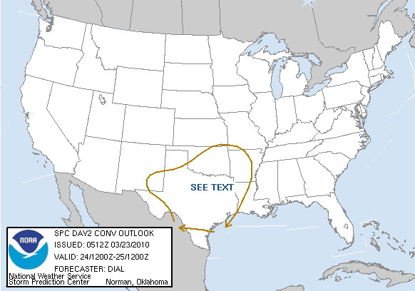
DAY 2 CONVECTIVE OUTLOOK
NWS STORM PREDICTION CENTER NORMAN OK
1212 AM CDT TUE MAR 23 2010
VALID 241200Z - 251200Z
...NO SVR TSTM AREAS FORECAST...
...SYNOPSIS...
PHASING BETWEEN A NRN STREAM IMPULSE NOW MOVING SEWD THROUGH THE NRN
ROCKIES AND UPPER LOW OFF THE NRN BAJA COAST IS FORECAST TO OCCUR
OVER THE WRN U.S. TUESDAY. THE TROUGH WILL CONTINUE INTO THE SRN
PLAINS AS AN OPEN WAVE WEDNESDAY. WEAK SURFACE LOW WILL LIKELY
DEVELOP IN ASSOCIATION WITH THE UPPER TROUGH AND LIFT NEWD ALONG
BAROCLINIC ZONE THROUGH NRN TX AND ERN OK WEDNESDAY NIGHT. TRAILING
PORTIONS OF COLD FRONT WILL SURGE SEWD THROUGH WRN AND CNTRL TX.
...TX...
RECENT INTRUSION OF CP AIR OVER THE GULF WILL ONLY ALLOW FOR PARTIAL
MODIFICATION OF THE GULF BOUNDARY LAYER WEDNESDAY WITH DEWPOINTS IN
THE 50S EXPECTED TO ADVECT NWWD THROUGH CNTRL/WRN TX AND LOW-MID 60S
LIKELY ACROSS S TX. INITIAL MOISTURE SURGE MAY RESULT IN FORMATION
OF WIDESPREAD STRATUS. INCREASING SWLY FLOW ALONG THE BASE OF UPPER
TROUGH WILL LIKELY ADVECT AN EML ABOVE THE MOIST AXIS CONTRIBUTING
TO DESTABILIZATION AS WELL AS A CAP. THE CAP WILL BE STRONGER FROM
S-CNTRL THROUGH S TX. GIVEN POTENTIAL FOR WIDESPREAD CLOUDS AND
MODEST LOW LEVEL MOISTURE RETURN...ONLY MARGINAL INSTABILITY IS
EXPECTED WITH MUCAPE GENERALLY AOB 500 J/KG.
ELEVATED CONVECTION WILL BE POSSIBLE WITHIN THE WARM ADVECTION ZONE
FROM CNTRL THROUGH N-CNTRL AND NE TX INTO OK DURING THE DAY.
DEVELOPMENT OF STRONGER STORMS WILL PROBABLY HOLD OFF UNTIL LATER
WEDNESDAY AFTERNOON AND OVERNIGHT WITHIN ZONE OF DEEPER FORCING AS
THE FRONT SURGES SEWD AND INTERCEPTS THE MOIST AXIS. THE LINE OF
STORMS WILL SUBSEQUENTLY SHIFT EWD TOWARD THE LOWER MS VALLEY
OVERNIGHT. ACTIVITY WILL BE EMBEDDED WITHING 40-50 KT SWLY DEEP
LAYER SHEAR SUFFICIENT FOR ORGANIZED STORM STRUCTURES. PRIMARY
THREAT WILL BE FOR ISOLATED STRONG WIND GUSTS AND HAIL. THREAT DOES
NOT APPEAR SUFFICIENT TO WARRANT MORE THAN 5% SEVERE PROBABILITIES
AT THIS TIME DUE TO AN EXPECTED MARGINAL THERMODYNAMIC ENVIRONMENT.
AREA WILL CONTINUE TO BE MONITORED...AND A SLIGHT RISK MIGHT BE
NEEDED IN LATER OUTLOOKS IF IT BEGINS TO APPEAR MORE INSTABILITY
WILL DEVELOP THAN CURRENTLY ANTICIPATED.
..DIAL.. 03/23/2010
Carla/Alicia/Jerry(In The Eye)/Michelle/Charley/Ivan/Dennis/Katrina/Rita/Wilma/Humberto/Ike/Harvey
Member: National Weather Association
Facebook.com/Weather Infinity
Twitter @WeatherInfinity
Member: National Weather Association
Facebook.com/Weather Infinity
Twitter @WeatherInfinity
-
srainhoutx
- Site Admin
- Posts: 19616
- Joined: Tue Feb 02, 2010 2:32 pm
- Location: Maggie Valley, NC
- Contact:
SPC has a Slight Risk up for parts of N Central TX and OK this morning...
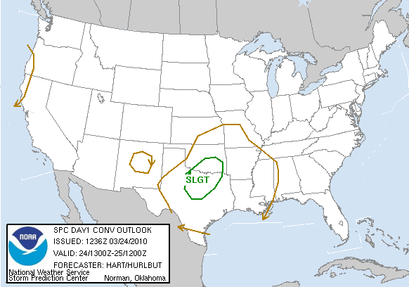
DAY 1 CONVECTIVE OUTLOOK
NWS STORM PREDICTION CENTER NORMAN OK
0736 AM CDT WED MAR 24 2010
VALID 241300Z - 251200Z
...THERE IS A SLGT RISK OF SVR TSTMS OVER PARTS OF OK/TX...
...OK/TX THIS AFTERNOON/EVENING...
A LARGE UPPER TROUGH OVER THE CENTRAL/SOUTHERN ROCKIES WILL TRACK
EASTWARD INTO THE PLAINS TODAY...WHILE A STRONG COLD FRONT SURGES
SOUTHWARD INTO WESTERN OK/TX. MEANWHILE...TO THE EAST OF THE
FRONT...SOUTHERLY LOW LEVEL WINDS WILL CONTINUE TO TRANSPORT GULF
MOISTURE NORTHWARD WITH DEWPOINTS IN THE MID/UPPER 50S EXPECTED
THROUGHOUT THE WARM SECTOR OF SOUTHERN OK/NORTH TX BY THIS
AFTERNOON. PARTIAL SUNSHINE AND COOLING TEMPERATURES ALOFT WILL
LEAD TO AFTERNOON MLCAPE VALUES OF AROUND 1000 J/KG.
THUNDERSTORMS ARE LIKELY TO INTENSIFY ALONG THE SURFACE COLD FRONT
OVER SOUTHWEST OK/WESTERN NORTH TX BY MID-LATE AFTERNOON
/PARTICULARLY NEAR FRONT/DRYLINE TRIPLE POINT/ AND SPREAD EASTWARD
ROUGHLY ALONG THE RED RIVER DURING THE EVENING. FORECAST SOUNDINGS
SHOW FAVORABLE THERMODYNAMIC PROFILES FOR A RISK OF LARGE HAIL AND
DAMAGING WINDS IN STRONGER STORMS. EFFECTIVE SHEAR VALUES OF 30-40
KNOTS WILL ALSO PROMOTE ORGANIZED MULTICELL AND SUPERCELL STORM
STRUCTURES... DESPITE RATHER WEAK LOW LEVEL WINDS. UNCERTAINTY IN
THE SEVERE THREAT INCREASES SOUTH OF I-20 WHERE A STRONGER CAP AND
WEAKER FORCING WILL BE PRESENT.
...ARKLATEX OVERNIGHT...
OVERNIGHT...MODEL GUIDANCE IS IN GOOD AGREEMENT THAT A SECONDARY LOW
LEVEL JET AXIS WILL DEVELOP OVER THE ARKLATEX REGION. THIS AREA
WILL SEE INCREASING CONVECTIVE ACTIVITY AFTER MIDNIGHT AS THE COLD
FRONT APPROACHES FROM THE WEST. FORECAST SOUNDINGS INDICATE THAT
LOW LEVEL HODOGRAPHS WILL BECOME MORE FAVORABLE FOR SUPERCELLS
DESPITE MARGINAL CAPE VALUES. WILL MAINTAIN LOW SEVERE/TORNADO
PROBABILITIES ACROSS THIS AREA FOR THE OVERNIGHT PERIOD...BUT WILL
NEED TO CONSIDER AN UPGRADE TO SLIGHT RISK IF LATER MODEL RUNS
SUGGEST GREATER MOISTENING/DESTABILIZATION COULD OCCUR.
..HART/HURLBUT.. 03/24/2010
Carla/Alicia/Jerry(In The Eye)/Michelle/Charley/Ivan/Dennis/Katrina/Rita/Wilma/Humberto/Ike/Harvey
Member: National Weather Association
Facebook.com/Weather Infinity
Twitter @WeatherInfinity
Member: National Weather Association
Facebook.com/Weather Infinity
Twitter @WeatherInfinity
-
Mrs.Frosty

- Posts: 42
- Joined: Thu Feb 04, 2010 10:10 am
- Location: Cleveland/Liberty County
- Contact:
Can we expect any severe weather around here today or overnight ? From the looks of it , the SPC has parts of the northern Counties in the 2% risk for Tornadoes ! :-/
Thanks so much in advance!
Thanks so much in advance!

Never say never, however the cap is expected to hold this far south and most of the severe weather will stay north and east of Houston.Mrs.Frosty wrote:Can we expect any severe weather around here today or overnight ? From the looks of it , the SPC has parts of the northern Counties in the 2% risk for Tornadoes ! :-/
Thanks so much in advance!
NWS writes:
"THE COLD FRONT WILL MOVE INTO SE TX BETWEEN 06Z AND 12Z THU WITH
THE BEST LIFT FROM THE SHORTWAVE PASSING ACROSS N TX. THIS WILL
LIKELY BE WHEN FORCED CONVECTION WILL BE STRONGEST BUT ANY SEVERE
STORM THREAT LOOKS TO BE NORTH OF A KCLL TO KLFK LINE. GIVEN THE
NOCTURNAL NATURE OF THE STORMS...INSTABILITY WILL BE LACKING. ANY
STORMS THAT DO HAPPEN TO TAP SOME HIGHER INSTABILITY MAY BE
CAPABLE OF SOME STRONG WIND GUSTS BUT DO NOT SEE MUCH IN THE WAY
OF A HAIL THREAT. A THIN LINE OF STORMS WILL LIKELY ACCOMPANY THE
FRONT THROUGH THE MORNING HOURS WITH MORE ISO ACTIVITY OFF TO THE
SW WHERE THE CAP IS STRONGER."
-
srainhoutx
- Site Admin
- Posts: 19616
- Joined: Tue Feb 02, 2010 2:32 pm
- Location: Maggie Valley, NC
- Contact:

MESOSCALE DISCUSSION 0208
NWS STORM PREDICTION CENTER NORMAN OK
0145 PM CDT WED MAR 24 2010
AREAS AFFECTED...CENTRAL TX AND VICINITY
CONCERNING...SEVERE POTENTIAL...WATCH POSSIBLE
VALID 241845Z - 242045Z
CONVECTION HAS BEGIN TO INCREASE ACROSS CENTRAL TX...WITH AN
EVENTUAL WW POSSIBLE.
SURFACE ANALYSIS SHOWS THE COLD FRONT CONTINUING TO PROGRESS SLOWLY
SEWD ACROSS SWRN OK AND THE WRN HALF OF TX...WITH A WEAK DRYLINE
ALSO EVIDENT ALONG ERN FRINGES OF THE TRANSPECOS REGION. AHEAD OF
THE FRONT/DRYLINE...BROKEN CLOUD COVER HAS ALLOWED SOME HEATING TO
OCCUR. THIS COMBINED WITH MODEST /UPPER 50S TO LOW 60S/ SURFACE
DEWPOINTS IS NOW RESULTING IN ROUGHLY 500 J/KG MIXED-LAYER CAPE.
LATEST RADAR LOOP REVEALS A VERY SLOW INCREASE IN CONVECTIVE UPDRAFT
INTENSITY...WITH THE FIRST COUPLE OF LIGHTNING STRIKES NOW OBSERVED
NEAR ABILENE. EXPECT A CONTINUED/SLOW INCREASE IN CONVECTION OVER
THE NEXT COUPLE OF HOURS...AS ADDITIONAL HEATING/DESTABILIZATION
OCCURS THIS AFTERNOON.
LOW-LEVEL FLOW FIELD ACROSS THE TX WARM SECTOR REMAINS SOMEWHAT
WEAK. HOWEVER...ENHANCED /40 TO 50 KT/ MID-LEVEL SWLYS ON THE SERN
FRINGE OF THE NM UPPER LOW IS CONTRIBUTING TO SHEAR SUFFICIENT FOR
ORGANIZED/SUPERCELL STORMS. THUS...EXPECT AN INCREASE IN HAIL
POTENTIAL AS STORMS STRENGTHEN THIS AFTERNOON...ALONG WITH THE
THREAT FOR AN ISOLATED/STRONGER GUST. THREAT WILL LIKELY BE
GREATEST ACROSS CENTRAL AND N TX...THOUGH ISOLATED STORMS/SEVERE
POTENTIAL MAY OCCUR AS FAR SW AS THE MID RIO GRANDE VALLEY.
..GOSS.. 03/24/2010
Carla/Alicia/Jerry(In The Eye)/Michelle/Charley/Ivan/Dennis/Katrina/Rita/Wilma/Humberto/Ike/Harvey
Member: National Weather Association
Facebook.com/Weather Infinity
Twitter @WeatherInfinity
Member: National Weather Association
Facebook.com/Weather Infinity
Twitter @WeatherInfinity
-
srainhoutx
- Site Admin
- Posts: 19616
- Joined: Tue Feb 02, 2010 2:32 pm
- Location: Maggie Valley, NC
- Contact:

BULLETIN - IMMEDIATE BROADCAST REQUESTED
SEVERE THUNDERSTORM WATCH OUTLINE UPDATE FOR WS 34
NWS STORM PREDICTION CENTER NORMAN OK
320 PM CDT WED MAR 24 2010
SEVERE THUNDERSTORM WATCH 34 IS IN EFFECT UNTIL 1000 PM CDT
FOR THE FOLLOWING LOCATIONS
TXC035-049-059-081-083-085-093-095-097-099-113-121-133-139-143-
147-181-193-217-221-231-251-257-267-281-307-319-327-333-363-367-
397-399-411-413-425-429-435-439-441-451-497-250300-
/O.NEW.KWNS.SV.A.0034.100324T2020Z-100325T0300Z/
TX
. TEXAS COUNTIES INCLUDED ARE
BOSQUE BROWN CALLAHAN
COKE COLEMAN COLLIN
COMANCHE CONCHO COOKE
CORYELL DALLAS DENTON
EASTLAND ELLIS ERATH
FANNIN GRAYSON HAMILTON
HILL HOOD HUNT
JOHNSON KAUFMAN KIMBLE
LAMPASAS MASON MCCULLOCH
MENARD MILLS PALO PINTO
PARKER ROCKWALL RUNNELS
SAN SABA SCHLEICHER SOMERVELL
STEPHENS SUTTON TARRANT
TAYLOR TOM GREEN WISE
ATTN...WFO...FWD...SJT...
Last edited by srainhoutx on Wed Mar 24, 2010 3:26 pm, edited 1 time in total.
Reason: Edit To Add Graphic
Reason: Edit To Add Graphic
Carla/Alicia/Jerry(In The Eye)/Michelle/Charley/Ivan/Dennis/Katrina/Rita/Wilma/Humberto/Ike/Harvey
Member: National Weather Association
Facebook.com/Weather Infinity
Twitter @WeatherInfinity
Member: National Weather Association
Facebook.com/Weather Infinity
Twitter @WeatherInfinity
With rain around, why is HGX still in clear-air mode (as of 3:50pm?)
-
sleetstorm
- Posts: 651
- Joined: Thu Feb 04, 2010 12:33 pm
- Contact:
Where did you obtain the degree symbol that some of you employed with the temperature? I would very much like to know.
-
sleetstorm
- Posts: 651
- Joined: Thu Feb 04, 2010 12:33 pm
- Contact:
Would that be the alt key+the number 0186, Ed Mahmoud?Ed Mahmoud wrote:sleetstorm wrote:Where did you obtain the degree symbol that some of you employed with the temperature? I would very much like to know.
alt 0186
º
Or just copy and paste...