Page 6 of 39
Re: May 2021
Posted: Tue May 11, 2021 9:08 am
by Cromagnum
don wrote: ↑Tue May 11, 2021 8:20 am
The EURO looks very wet starting this weekend and through next week, we'll see.
Starting what day this weekend? I've got a fishing trip planned Saturday.
Re: May 2021
Posted: Tue May 11, 2021 9:50 am
by don
Rights now the NWS has a 60% chance of rain Saturday night and a 70% on Sunday, but exact timing and how much rain coverage we get this weekend is still questionable.We'll need to see a few more model runs over the next few days to see if the wet trend continues.
Re: May 2021
Posted: Tue May 11, 2021 10:09 am
by Cpv17
Tomorrow doesn’t look like much per the latest mesoscale models. Probably because it has the storm coming through in the morning and it has the line weakening as it pushes through the area. If it were to come through a few hours earlier or during the evening hours when there’s more instability in the atmosphere then we’d probably be looking at some good rains.
Re: May 2021
Posted: Tue May 11, 2021 11:12 am
by DoctorMu
The atmosphere looks more stable today. Massive bust so far, and now on the wrong side of the front in CLL. Potential for a line coming through late this afternoon. The models are faring poorly up until now.
The stuff in the Bay of Campeche is not headed this way. Just a bit too early.
Re: May 2021
Posted: Tue May 11, 2021 12:56 pm
by Iceresistance
DoctorMu wrote: ↑Tue May 11, 2021 11:12 am
The atmosphere looks more stable today. Massive bust so far, and now on the wrong side of the front in CLL. Potential for a line coming through late this afternoon. The models are faring poorly up until now.
The stuff in the Bay of Campeche is not headed this way. Just a bit too early.
And it's gone . . .
Re: May 2021
Posted: Tue May 11, 2021 1:48 pm
by don
The EURO is showing some really high rainfall totals this weekend,definitely something to watch over the next few days.
Re: May 2021
Posted: Tue May 11, 2021 1:52 pm
by jasons2k
Getting busy...
Re: May 2021
Posted: Tue May 11, 2021 2:29 pm
by DoctorMu
Tornado Warning - east of Madisonville.:
https://twitter.com/chrisnunley/status/ ... 78209?s=20
Message: NOAA-NWS-ALERTS-TX1261A0570724.TornadoWarning.1261A0571DCCTX.HGXTORHGX.55aa1c0ba11dd7e0a8abc9018442df78 from
w-nws.webmaster@noaa.gov
Sent: 13:57 CDT on 05-11-2021
Effective: 13:57 CDT on 05-11-2021
Expires: 14:15 CDT on 05-11-2021
Event: Tornado Warning
Alert:
The National Weather Service in League City has issued a
* Tornado Warning for...
Southwestern Houston County in southeastern Texas...
Northeastern Madison County in southeastern Texas...
North central Walker County in southeastern Texas...
* Until 215 PM CDT.
* At 157 PM CDT, a severe thunderstorm capable of producing a tornado
was located 13 miles south of Austonio, moving northeast at 15 mph.
HAZARD...Tornado and quarter size hail.
SOURCE...Radar indicated rotation.
IMPACT...Flying debris will be dangerous to those caught without
shelter. Mobile homes will be damaged or destroyed.
Damage to roofs, windows, and vehicles will occur. Tree
damage is likely.
* This tornadic thunderstorm will remain over mainly rural areas of
southwestern Houston, northeastern Madison and north central Walker
Counties.
TORNADO...RADAR INDICATED
HAIL...1.00IN
Re: May 2021
Posted: Tue May 11, 2021 3:20 pm
by jasons2k
URGENT - IMMEDIATE BROADCAST REQUESTED
Severe Thunderstorm Watch Number 164
NWS Storm Prediction Center Norman OK
305 PM CDT Tue May 11 2021
The NWS Storm Prediction Center has issued a
* Severe Thunderstorm Watch for portions of
Parts of east central and southeast Texas
* Effective this Tuesday afternoon and evening from 305 PM until
900 PM CDT.
* Primary threats include...
Scattered large hail and isolated very large hail events to 2
inches in diameter possible
Scattered damaging wind gusts to 70 mph possible
A tornado or two possible
SUMMARY...Isolated supercells along a surface front may persist for another couple of hours, prior to outflow from central Texas
convection overtaking the front and leading to additional storm
development and intensification. An brief tornado or two may occur in the short term, but large hail and damaging winds will be the main threats through the afternoon/evening as storm coverage increases.
The severe thunderstorm watch area is approximately along and 55 statute miles east and west of a line from 45 miles north northwest of Lufkin TX to 35 miles southeast of College Station TX. For a complete depiction of the watch see the associated watch outline update (WOUS64 KWNS WOU4).
Re: May 2021
Posted: Tue May 11, 2021 3:56 pm
by DoctorMu
That should read 35 miles southWEST of College Station. Pretty nice wall cloud to the west. Light rain here.
Re: May 2021
Posted: Tue May 11, 2021 4:21 pm
by DoctorMu
Very heavy rain here at A&M. Evidently light rain at home.
Re: May 2021
Posted: Tue May 11, 2021 4:29 pm
by DoctorMu
No hail here, but lots of wind and rain.
Message: NOAA-NWS-ALERTS-TX1261A05769F8.SevereThunderstormWarning.1261A05777A4TX.HGXSVRHGX.589148d75cacc57ce36cd20d969fe874 from
w-nws.webmaster@noaa.gov
Sent: 16:10 CDT on 05-11-2021
Effective: 16:10 CDT on 05-11-2021
Expires: 16:45 CDT on 05-11-2021
Event: Severe Thunderstorm Warning
Alert:
The National Weather Service in League City has issued a
* Severe Thunderstorm Warning for...
Northwestern Grimes County in southeastern Texas...
East central Burleson County in southeastern Texas...
Southeastern Brazos County in southeastern Texas...
* Until 445 PM CDT.
* At 410 PM CDT, a severe thunderstorm was located near College
Station, moving east at 25 mph.
HAZARD...60 mph wind gusts and quarter size hail.
SOURCE...Radar indicated.
IMPACT...Hail damage to vehicles is expected. Expect wind damage
to roofs, siding, and trees.
* Locations impacted include...
College Station, Millican, Kyle Field, Wellborn and Carlos.
HAIL...1.00IN
WIND...60MPH
Instructions: For your protection move to an interior room on the lowest floor of a building.
Target Area:
Brazos
Burleson
Grimes
Re: May 2021
Posted: Tue May 11, 2021 4:57 pm
by jasons2k
Mesoscale Discussion 0595
NWS Storm Prediction Center Norman OK
0437 PM CDT Tue May 11 2021
Areas affected...East-central Texas and far southwest Louisiana
Concerning...Severe Thunderstorm Watch 164...
Valid 112137Z - 112300Z
The severe weather threat for Severe Thunderstorm Watch 164
continues.
SUMMARY...Severe storms in east-central Texas may move out of watch
164 in the next few hours.
DISCUSSION...The strongest storms within watch 164 are moving into
Trinity county, Texas at 2130Z. The environment downstream of this
ongoing activity remains favorable with 1500 to 2000 J/kg MLCAPE and
effective shear around 35 to 40 knots per SPC mesoanalysis. In
addition, this activity is located near a warm frontal boundary.
Locally backed winds near this boundary are increasing low-level
SRH. The KPOE VWP can be used as a proxy for this low-level shear
profile and it is showing 0-1 SRH in excess of 200 m2/s2 and flow
around 2km has increased to around 45 knots. Therefore, a localized
tornado threat will exist near this warm front over the next few
hours as these storms move across east-central Texas.
In addition, given the favorable downstream environment, this
activity may persist east of watch 164 and a downstream watch may be
needed across portions of southeast Texas and southwest Louisiana.
..Bentley/Hart.. 05/11/2021
...Please see
www.spc.noaa.gov for graphic product...
ATTN...WFO...LCH...SHV...HGX...
Re: May 2021
Posted: Tue May 11, 2021 5:49 pm
by djmike
I may actually get more than 3 drops in Beaumont finally. Yippee!
Re: May 2021
Posted: Tue May 11, 2021 5:51 pm
by unome
Re: May 2021
Posted: Tue May 11, 2021 6:21 pm
by jasons2k
Haha
Re: May 2021
Posted: Tue May 11, 2021 6:59 pm
by djmike
Uh oh. May get more than I bargained for in Beaumont. Feast or famine.
Re: May 2021
Posted: Tue May 11, 2021 7:01 pm
by suprdav2
Not a drop here in Cypress. Got re6dark and windy, then poof.....nothing.
I blame my neighbor who decided to put on their sprinklers.
Re: May 2021
Posted: Tue May 11, 2021 7:05 pm
by jasons2k
Got a whole 0.11”
Re: May 2021
Posted: Tue May 11, 2021 7:09 pm
by Cpv17
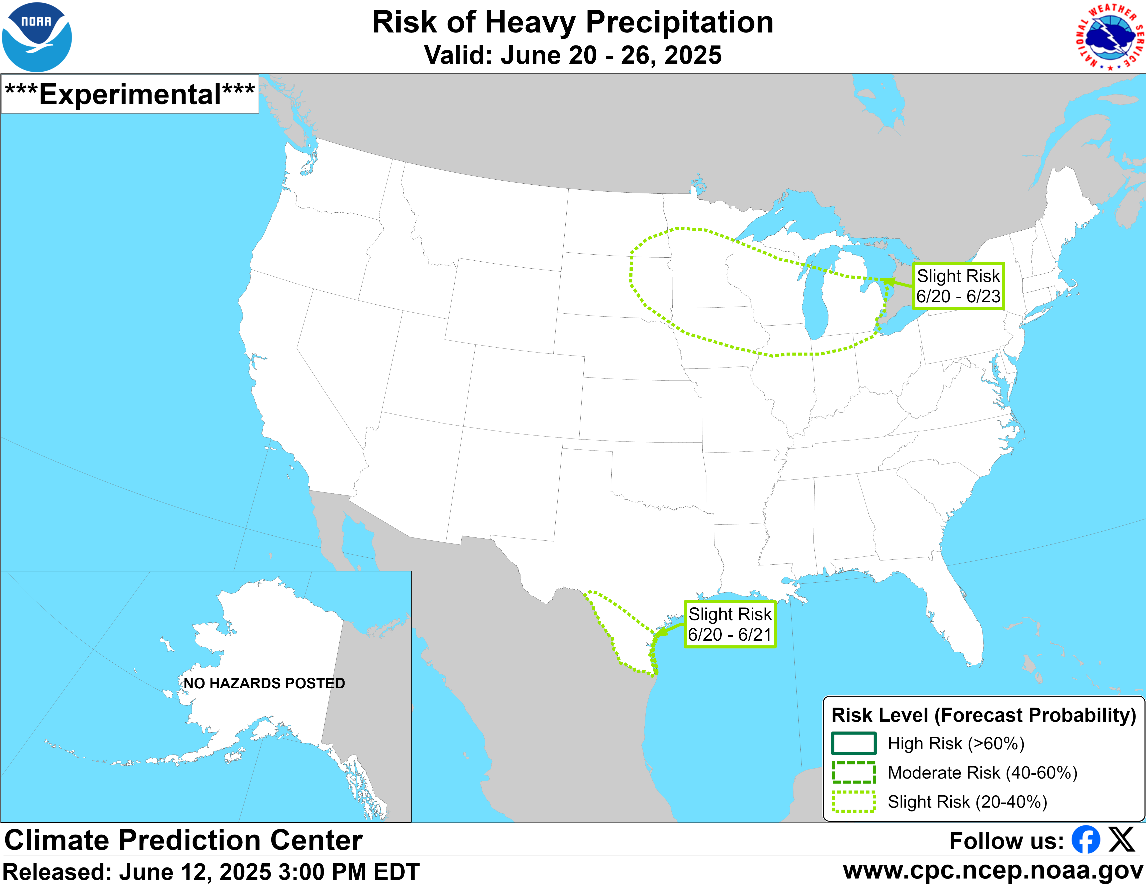
I don’t really think I’m going to get anything from this event here in Wharton. All good though. Don’t need any rain. By the looks of it, we could all be flooded out by next week:


That’s one heck of rain signal from the CPC directly over southeast TX.


