Page 38 of 64
Re: September 2020: Tracking TS Beta
Posted: Sat Sep 19, 2020 11:52 pm
by Rip76
Re: September 2020: Tracking TS Beta
Posted: Sun Sep 20, 2020 1:31 am
by Rip76
Re: September 2020: Tracking TS Beta
Posted: Sun Sep 20, 2020 1:32 am
by biggerbyte
It sure is trying tonight. Looking a bit better.
Re: September 2020: Tracking TS Beta
Posted: Sun Sep 20, 2020 1:35 am
by Rip76
biggerbyte wrote: ↑Sun Sep 20, 2020 1:32 am
It sure is trying tonight. Looking a bit better.
But that’s not moving West.
Re: September 2020: Tracking TS Beta
Posted: Sun Sep 20, 2020 2:41 am
by DoctorMu
Rip76 wrote: ↑Sat Sep 19, 2020 11:48 pm
Still cruising NNE?
That's shear.
Re: September 2020: Tracking TS Beta
Posted: Sun Sep 20, 2020 5:22 am
by Snakeswx
Nocturnal core rainfall .. looks like a good setup for it no? With the center very near downtown?
Re: September 2020: Tracking TS Beta
Posted: Sun Sep 20, 2020 7:16 am
by don
The edge of tropical storm Beta is already showing up on local radar.
Re: September 2020: Tracking TS Beta
Posted: Sun Sep 20, 2020 8:08 am
by redneckweather
In other news, 63 degrees up here around Lake Conroe with a nice northerly breeze!
Re: September 2020: Tracking TS Beta
Posted: Sun Sep 20, 2020 8:10 am
by unome
https://twitter.com/NWSHouston/status/1 ... 5437504512
@NWSHouston
Minor/Moderate Coastal flooding is currently ongoing!
The tide gauge at Galveston Railroad Bridge has seen water levels at 2.93ft above MHHW this morning - the highest water level this site has ever reported!
It should be noted this gauge has only been around since 2012. #GLSwx
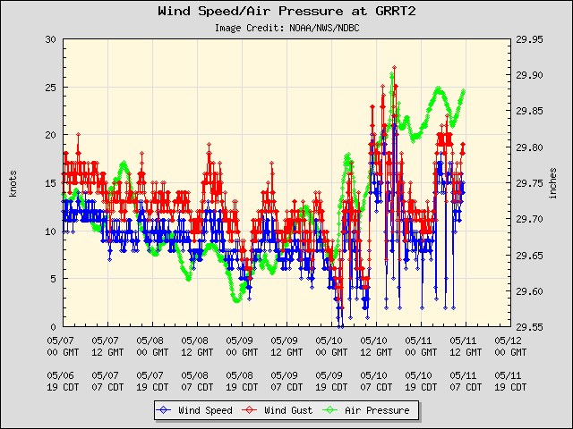
link to NDBC data for this site:
https://www.ndbc.noaa.gov/station_page. ... tion=grrt2
Galveston Buoycam, Station 42035:
https://www.ndbc.noaa.gov/station_page. ... tion=42035
Latest Image from 42035:
https://www.ndbc.noaa.gov/buoycam.php?station=42035
Re: September 2020: Tracking TS Beta
Posted: Sun Sep 20, 2020 8:20 am
by unome
Re: September 2020: Tracking TS Beta
Posted: Sun Sep 20, 2020 9:42 am
by Cromagnum
This storm is in opposite world. It dies down during DMax and flares up during DMin
Re: September 2020: Tracking TS Beta
Posted: Sun Sep 20, 2020 9:45 am
by Scott747
Something weird is up with the new recon obs. Readings new hurricane force gusts. Not sure if it's rain contaminated. Also the center might be a little further nw.
Re: September 2020: Tracking TS Beta
Posted: Sun Sep 20, 2020 9:55 am
by TexasBreeze
It sure does look well organised south of Lake Charles. Mid level circulation on radar there in the middle of the storm cells?
Re: September 2020: Tracking TS Beta
Posted: Sun Sep 20, 2020 9:56 am
by Kingwood36
Anyone know where I can find radar to look at beta?
Re: September 2020: Tracking TS Beta
Posted: Sun Sep 20, 2020 9:58 am
by Scott747
This is surprisingly a decent set of recon obs. It's far better than the entire mission last night. Definitely still a 50kt storm and they could even increase it a bit.
Re: September 2020: Tracking TS Beta
Posted: Sun Sep 20, 2020 9:59 am
by Stormlover2020
Scott, is the new center farther north ?
Re: September 2020: Tracking TS Beta
Posted: Sun Sep 20, 2020 10:00 am
by Rip76
I noticed on the WV loop this morning that some of that dry air looked like it was getting pushed back a bit.
Re: September 2020: Tracking TS Beta
Posted: Sun Sep 20, 2020 10:03 am
by weatherguy425
Scott747 wrote: ↑Sun Sep 20, 2020 9:58 am
This is surprisingly a decent set of recon obs. It's far better than the entire mission last night. Definitely still a 50kt storm and they could even increase it a bit.
Re: September 2020: Tracking TS Beta
Posted: Sun Sep 20, 2020 10:08 am
by Scott747
Stormlover2020 wrote: ↑Sun Sep 20, 2020 9:59 am
Scott, is the new center farther north ?
As of now, no indication from the recon obs. Thought there was a hint of one just to the NW.
Re: September 2020: Tracking TS Beta
Posted: Sun Sep 20, 2020 10:11 am
by Scott747
weatherguy425 wrote: ↑Sun Sep 20, 2020 10:03 am
Scott747 wrote: ↑Sun Sep 20, 2020 9:58 am
This is surprisingly a decent set of recon obs. It's far better than the entire mission last night. Definitely still a 50kt storm and they could even increase it a bit.
That's one hell of a vortex then because there were finding similar obs well removed from it to the w.
