
September 2020:

Latest runs of the HRRR model now shows the core rains starting earlier mid afternoon into the evening/night, instead of overnight. The NWS is calling for up to 20+ inches of rain in some areas especially in metro Houston where more than 12 inches of rain has fallen overnight over the southwest side.
Looks quiet for a large part of the area right now (not counting downtown obviously). So it looks like the fireworks start this afternoon?
Still moving NW at a snails pace. Seems to be moving inland much more than expected. When are they now expecting it to make a turn to the NE?
Later this afternoon or evening.
So is that 20+ on top of the 12 that’s already fallen or more rain to get to 20+?don wrote: ↑Tue Sep 22, 2020 8:34 am Latest runs of the HRRR model now shows the core rains starting earlier mid afternoon into the evening/night, instead of overnight. The NWS is calling for up to 20+ inches of rain in some areas especially in metro Houston where more than 12 inches of rain has fallen overnight over the southwest side.
More rain to get up to 20+ inches. 5-10 inches of more rain is possible today.Texashawk wrote: ↑Tue Sep 22, 2020 8:56 amSo is that 20+ on top of the 12 that’s already fallen or more rain to get to 20+?don wrote: ↑Tue Sep 22, 2020 8:34 am Latest runs of the HRRR model now shows the core rains starting earlier mid afternoon into the evening/night, instead of overnight. The NWS is calling for up to 20+ inches of rain in some areas especially in metro Houston where more than 12 inches of rain has fallen overnight over the southwest side.
-
MontgomeryCoWx

- Posts: 2356
- Joined: Wed Dec 14, 2011 4:31 pm
- Location: Weimar, TX
- Contact:
Woooo Hooo…. go back to Hell Summer!
3 inches in Magnolia so far. I'd love to get 6-8 out of this.
3 inches in Magnolia so far. I'd love to get 6-8 out of this.
Team #NeverSummer
Where is the graphic showing this?don wrote: ↑Tue Sep 22, 2020 9:06 amMore rain to get up to 20+ inches. 5-10 inches of more rain is possible today.Texashawk wrote: ↑Tue Sep 22, 2020 8:56 amSo is that 20+ on top of the 12 that’s already fallen or more rain to get to 20+?don wrote: ↑Tue Sep 22, 2020 8:34 am Latest runs of the HRRR model now shows the core rains starting earlier mid afternoon into the evening/night, instead of overnight. The NWS is calling for up to 20+ inches of rain in some areas especially in metro Houston where more than 12 inches of rain has fallen overnight over the southwest side.
Its from this mornings discussion. WPC has also issued a high risk for flash flooding in metro Houston.
National Weather Service Houston/Galveston TX
356 AM CDT Tue Sep 22 2020
...Very Dangerous Flash Flood Threat Continues to Develop...
.SHORT TERM [Today through Wednesday]...
Tropical Storm Beta made landfall Monday evening and is centered to
the west of the Edna area early this morning. Rainbands associated
with Beta`s circulation, similar to the ones that developed Monday
evening and caused flash flooding in/around the South Houston/Pearland/
Friendswood/League City areas, have continued to develop early this
morning with some in and around the same locations that received 5 to
8 inches of rain yesterday. Lots of short term and high resolution
models have been consistent in developing additional rainbands during
the remaining overnight hours and out through at least the morning hours.
If this pans out, especially over already hard hit locations, dangerous
flooding and flash flooding will occur, including on area creeks, bayous
and rivers. Beta`s slow forecasted movement over the next 24 to 36 hours
will favor additional banding development. If this happens, especially
over the same areas over and over again, dangerous flooding and flash
flooding could continue on into tonight and Wednesday morning, including
in and near locations that have been experiencing some surge related
flooding from this system. Additional rainfall totals of 5 to 10 inches
or more will be possible with the persistent banding, and this could
easily make Beta`s isolated totals reach or exceed 20 inches. 42
- Attachments
-
Last edited by don on Tue Sep 22, 2020 9:17 am, edited 1 time in total.
Wow clear creek is wayyyy over its banks! That’s not good with the training still ongoing over the area and more to come.
-
Katdaddy

- Global Moderator

- Posts: 2502
- Joined: Thu Feb 04, 2010 8:18 am
- Location: League City, Tx
- Contact:
9.40" in W League City as of 8:05AM and yes the Clear Creek watershed has taking a pounding. Things could get a lot worse should core rains develop over the watershed but we know the training is continuing this morning.

The sun just for a sec.
-
Kingwood36
- Posts: 1592
- Joined: Sat Dec 29, 2018 10:29 am
- Location: Freeport
- Contact:
In a dry slot here in brazoria county..finally...will the rain begin to build back in later Today?
It is expected to start filling in this afternoon into tonight per latest mesoscale model runs. HRRR is running right nowKingwood36 wrote: ↑Tue Sep 22, 2020 10:08 am In a dry slot here in brazoria county..finally...will the rain begin to build back in later Today?
https://www.tropicaltidbits.com/analysi ... 92214&fh=1

Clear Creek today:


Clear Creek is normally supposed to look like this, for reference:
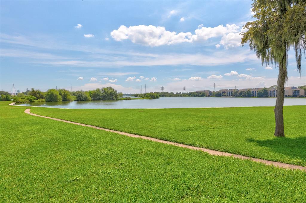
This is Clear Creek just before it empties into Clear Lake.
Clear Creek is normally supposed to look like this, for reference:
This is Clear Creek just before it empties into Clear Lake.
Great pics and I would be pretty worried if I were in those apartments!
The HRRR seems to move most of the rain out after about 11 hours. Coupled with the dry slot to the south and the dry air entrainment it looks (hopes?) like the worst may be over...
-
vci_guy2003
- Posts: 203
- Joined: Mon Jun 28, 2010 4:04 am
- Contact:
Does anyone have the rain total for Hobby airport?
-
- Information
-
Who is online
Users browsing this forum: Ahrefs [Bot], Bing [Bot], DoctorMu, TexasBreeze and 64 guests