it's going to be a long day for a lot of folks in the south
https://www.spc.noaa.gov/products/md/
https://www.wpc.ncep.noaa.gov/metwatch/metwatch_mpd.php
https://www.spc.noaa.gov/products/outlook/pwo.html
Public Severe Weather Outlook (PWO)
Print Version
Note: During early morning hours (approximately 6am Central time), the SPC will produce a multimedia briefing MP4 file shortly after the PWO issuance. Please check back momentarily for a link to this MP4 file on this page. Please note the briefing may be out of date 5 hours after its issuance and there will be no subsequent updates during the day. Please send comments or questions to spc.feedback@noaa.gov or via the feedback page.
ZCZC SPCPWOSPC ALL
WOUS40 KWNS 190718
ALZ000-FLZ000-GAZ000-LAZ000-MSZ000-TXZ000-191800-
PUBLIC SEVERE WEATHER OUTLOOK
NWS STORM PREDICTION CENTER NORMAN OK
0218 AM CDT SUN APR 19 2020
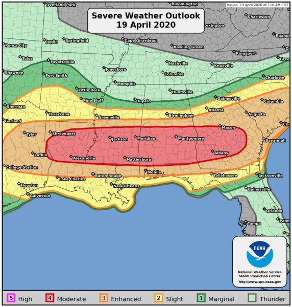
...Severe thunderstorms expected over parts of the southeast US
later today and tonight...
* LOCATIONS...
Central and southern Alabama
Central and southern Georgia
Northwestern Florida Panhandle
Central and southern Mississippi
Central and northern Louisiana
East Texas
* HAZARDS...
Widespread damaging winds, some hurricane force
Several tornadoes, a few intense
Scattered large hail, some baseball size
* SUMMARY...
An outbreak of tornadoes and severe thunderstorms is expected
today from parts of the lower Mississippi Valley across much of
the the Southeast. In addition to tornadoes, many of the storms
will have very large hail and wind damage. The severe threat
will be greatest from north-central Louisiana eastward to
southern and central Mississippi, southern and central Alabama
into south-central Georgia. Additional severe storms with a
threat for tornadoes, wind damage and hail will be possible in
parts of east Texas this morning and in the Carolinas tonight.
Preparedness actions...
Review your severe weather safety procedures for the possibility
of dangerous weather today. Stay tuned to NOAA Weather Radio,
weather.gov, or other media for watches and warnings. A watch
means that conditions are favorable for severe thunderstorms
over the next several hours. If a severe thunderstorm warning is
issued for your area, move to a place of safety, ideally in an
interior room on the lowest floor of a sturdy building.
&&
..Edwards.. 04/19/2020
$$
April 2020
New MD from the SPC, tornado watch likely in the next hour or two. I’m guessing the rain along 10 isn’t going to zap the atmosphere of energy?
https://www.spc.noaa.gov/products/md/md0401.html
- Katdaddy
- Global Moderator
- Posts: 2502
- Joined: Thu Feb 04, 2010 8:18 am
- Location: League City, Tx
- Contact:
A Tornado Watch will be issued for SE TX this morning. Remain weather aware.
Mesoscale Discussion 0401
NWS Storm Prediction Center Norman OK
0722 AM CDT Sun Apr 19 2020
Areas affected...portions of central and southeastern TX into far western LA
Concerning...Severe potential...Tornado Watch likely
Valid 191222Z - 191415Z
Probability of Watch Issuance...95 percent
SUMMARY...Thunderstorm activity will increase through the morning from central into southeastern Texas. Very large hail, a few tornadoes and damaging wind gusts are all possible. A tornado watch will likely be needed in the next 1-2 hours.
DISCUSSION...Elevated convection is increasing this morning across
portions of central TX with large-scale ascent increasing as a
shortwave trough begins to eject eastward from NM into western TX.
Initial convection will likely remain elevated for a couple of hours
until stronger heating after sunrise allows surface inhibition to
erode and as a warm front draped across the area continues to lift
northward. Nevertheless, very steep midlevel lapse rates (7.5-8.5
C/km) are contributing to MUCAPE values around 2000 J/kg per 12z
mesoanalysis and the 12z FWD RAOB. Effective shear is sufficient for
storm organization currently, and will continue to improve over the
next few hours. Large hail (some potentially greater than 2 inches
in diameter) will be the main concern in the immediate near-term,
especially with any discrete cells.
With time, convection will become surface-based as it approaches far
eastern TX and the Sabine River Valley late this morning. As this
occurs, an increasing threat for tornadoes and damaging winds will
accompany convection. While low level hodographs will become
enlarged by late morning into the afternoon, deep-layer winds are
rather unidirectional above 3km. This could result in storm
interactions and clustering toward midday, with a mix of
semi-discrete cells and clusters/bowing segments. As such, all
severe hazards are anticipated and some locations could see more
than one round of severe storms.
- srainhoutx
- Site Admin
- Posts: 19616
- Joined: Tue Feb 02, 2010 2:32 pm
- Location: Maggie Valley, NC
- Contact:
- Katdaddy
- Global Moderator
- Posts: 2502
- Joined: Thu Feb 04, 2010 8:18 am
- Location: League City, Tx
- Contact:
Tornado Watch until 3PM for all of SE TX. Some strong wording from the SPC.......A few tornadoes likely with a couple intense tornadoes possible
Remain weather aware today.
URGENT - IMMEDIATE BROADCAST REQUESTED
Tornado Watch Number 120
NWS Storm Prediction Center Norman OK
840 AM CDT Sun Apr 19 2020
The NWS Storm Prediction Center has issued a
* Tornado Watch for portions of
Western Louisiana
East Texas
Coastal Waters
* Effective this Sunday morning and afternoon from 840 AM until
300 PM CDT.
* Primary threats include...
A few tornadoes likely with a couple intense tornadoes possible
Widespread large hail and isolated very large hail events to 2.5 inches in diameter likely
Scattered damaging wind gusts to 70 mph likely
SUMMARY...Thunderstorms are expected to intensify this morning
across east Texas and spread across the watch area through the
afternoon. Large hail is the primary threat this morning. But
increasing winds aloft will promote a risk of tornadoes by early
afternoon.
The tornado watch area is approximately along and 105 statute miles
east and west of a line from 20 miles north of Shreveport LA to 55
miles southeast of Angleton TX. For a complete depiction of the
watch see the associated watch outline update (WOUS64 KWNS WOU0).
PRECAUTIONARY/PREPAREDNESS ACTIONS...
REMEMBER...A Tornado Watch means conditions are favorable for
tornadoes and severe thunderstorms in and close to the watch
area. Persons in these areas should be on the lookout for
threatening weather conditions and listen for later statements
and possible warnings.
- Katdaddy
- Global Moderator
- Posts: 2502
- Joined: Thu Feb 04, 2010 8:18 am
- Location: League City, Tx
- Contact:
BULLETIN - IMMEDIATE BROADCAST REQUESTED
SEVERE THUNDERSTORM WARNING
NATIONAL WEATHER SERVICE HOUSTON/GALVESTON TX
902 AM CDT SUN APR 19 2020
THE NATIONAL WEATHER SERVICE IN LEAGUE CITY HAS ISSUED A
* SEVERE THUNDERSTORM WARNING FOR...
NORTHEASTERN FORT BEND COUNTY IN SOUTHEASTERN TEXAS...
CENTRAL HARRIS COUNTY IN SOUTHEASTERN TEXAS...
* UNTIL 945 AM CDT.
* AT 901 AM CDT, A SEVERE THUNDERSTORM WAS LOCATED OVER SOUTHEASTERN
ADDICKS PARK TEN, MOVING EAST AT 40 MPH.
HAZARD...QUARTER SIZE HAIL.
SOURCE...RADAR INDICATED.
IMPACT...DAMAGE TO VEHICLES IS EXPECTED.
* LOCATIONS IMPACTED INCLUDE...
BELLAIRE, HUMBLE, WEST UNIVERSITY PLACE, GALENA PARK, JACINTO CITY,
JERSEY VILLAGE, HUNTERS CREEK VILLAGE, BUNKER HILL VILLAGE, PINEY
POINT VILLAGE, MIDTOWN HOUSTON, CLOVERLEAF, DOWNTOWN HOUSTON,
NORTHSIDE / NORTHLINE, GREENWAY / UPPER KIRBY AREA, SPRING BRANCH
NORTH, SECOND WARD, GREATER GREENSPOINT, GREATER HEIGHTS, HIGHLANDS
AND MISSION BEND.
a good day to just keep them refreshed
https://twitter.com/iembot_hgx
https://map.blitzortung.org/#5.18/31.246/-97.144
https://twitter.com/iembot_hgx
https://map.blitzortung.org/#5.18/31.246/-97.144
- srainhoutx
- Site Admin
- Posts: 19616
- Joined: Tue Feb 02, 2010 2:32 pm
- Location: Maggie Valley, NC
- Contact:
Crosby area about to get it
Don't like that velocity signature.
Rain all over.....except here in League City. Again
Arghhhhhhh!!!!!
Arghhhhhhh!!!!!
- srainhoutx
- Site Admin
- Posts: 19616
- Joined: Tue Feb 02, 2010 2:32 pm
- Location: Maggie Valley, NC
- Contact:
Collin Myers ABC13
@collinabc13
OMG LOOK AT OUR HOUSTON CAM right now. Our camera is IN THE CLOUD BASE of the Supercell!
My goodness.
@abc13houston
http://abc13.com/weather
Carla/Alicia/Jerry(In The Eye)/Michelle/Charley/Ivan/Dennis/Katrina/Rita/Wilma/Humberto/Ike/Harvey
Member: National Weather Association
Facebook.com/Weather Infinity
Twitter @WeatherInfinity
Member: National Weather Association
Facebook.com/Weather Infinity
Twitter @WeatherInfinity
https://twitter.com/NWSHouston/status/1 ... 0747508737
First round of storms have been moving through the area. The airmass over SETX is destabilizing and the threat of severe storms starting to increase again over the red highlighted area. A Tornado Watch is in effect.
Wow that’s an impressive photo of Houston! Pretty crazy storm. Looks like more developing SW, I def need it BAD but don’t need the hail, or tornadoes!
- Katdaddy
- Global Moderator
- Posts: 2502
- Joined: Thu Feb 04, 2010 8:18 am
- Location: League City, Tx
- Contact:
Watching that strong cell SW of Houston headed NE. Yes I could also use a little more rai as well but no hail, damaging winds, or a tornado.
Special Weather Statement
National Weather Service Houston/Galveston TX
1133 AM CDT Sun Apr 19 2020
TXZ226-235-191700-
Wharton TX-Inland Jackson TX-
1133 AM CDT Sun Apr 19 2020
...SIGNIFICANT WEATHER ADVISORY...
At 1131 AM CDT, Doppler radar was tracking a strong thunderstorm near
Edna, moving northeast at 40 mph.
Half inch hail will be possible with this storm.
Locations impacted include...
Edna, Ganado, Cordele and Louise.
A Tornado Watch remains in effect until 300 PM CDT for south central
and southeastern Texas.
- Attachments
-
- Screen Shot 2020-04-19 at 11.58.39 AM.png (101.51 KiB) Viewed 4297 times
Now that is surfaced based convection. Wow.srainhoutx wrote: ↑Sun Apr 19, 2020 11:28 am
Collin Myers ABC13
@collinabc13
OMG LOOK AT OUR HOUSTON CAM right now. Our camera is IN THE CLOUD BASE of the Supercell!
My goodness.
@abc13houston
http://abc13.com/weather
- Katdaddy
- Global Moderator
- Posts: 2502
- Joined: Thu Feb 04, 2010 8:18 am
- Location: League City, Tx
- Contact:
Cell to the SW is now severe:
Severe Thunderstorm Warning
TXC239-321-481-191745-
/O.NEW.KHGX.SV.W.0034.200419T1705Z-200419T1745Z/
BULLETIN - IMMEDIATE BROADCAST REQUESTED
Severe Thunderstorm Warning
National Weather Service Houston/Galveston TX
1205 PM CDT Sun Apr 19 2020
The National Weather Service in League City has issued a
* Severe Thunderstorm Warning for...
Wharton County in southeastern Texas...
Northeastern Jackson County in south central Texas...
Northwestern Matagorda County in southeastern Texas...
* Until 1245 PM CDT.
* At 1203 PM CDT, a severe thunderstorm was located near Ganado, or
12 miles northeast of Edna, moving northeast at 30 mph.
HAZARD...60 mph wind gusts and quarter size hail.
SOURCE...Radar indicated.
IMPACT...Hail damage to vehicles is expected. Wind damage to
roofs, siding, and trees is possible.
* Locations impacted include...
El Campo, Wharton, Edna, Ganado, Pierce, Cordele, Egypt, Louise and
Danevang.
PRECAUTIONARY/PREPAREDNESS ACTIONS...
A Tornado Watch remains in effect until 300 PM CDT for south central
and southeastern Texas.
For your protection move to an interior room on the lowest floor of a
building.
Severe Thunderstorm Warning
TXC239-321-481-191745-
/O.NEW.KHGX.SV.W.0034.200419T1705Z-200419T1745Z/
BULLETIN - IMMEDIATE BROADCAST REQUESTED
Severe Thunderstorm Warning
National Weather Service Houston/Galveston TX
1205 PM CDT Sun Apr 19 2020
The National Weather Service in League City has issued a
* Severe Thunderstorm Warning for...
Wharton County in southeastern Texas...
Northeastern Jackson County in south central Texas...
Northwestern Matagorda County in southeastern Texas...
* Until 1245 PM CDT.
* At 1203 PM CDT, a severe thunderstorm was located near Ganado, or
12 miles northeast of Edna, moving northeast at 30 mph.
HAZARD...60 mph wind gusts and quarter size hail.
SOURCE...Radar indicated.
IMPACT...Hail damage to vehicles is expected. Wind damage to
roofs, siding, and trees is possible.
* Locations impacted include...
El Campo, Wharton, Edna, Ganado, Pierce, Cordele, Egypt, Louise and
Danevang.
PRECAUTIONARY/PREPAREDNESS ACTIONS...
A Tornado Watch remains in effect until 300 PM CDT for south central
and southeastern Texas.
For your protection move to an interior room on the lowest floor of a
building.
There’s a severe warned storm really close to me right now just to my sw. It kinda looks like it’s going to miss me just to my south and east. Looks like it wants to split the gap between my house and the Wharton/El Campo area. I’m 10 miles north of El Campo and 10 miles west of Wharton.
Yeah it’s going to miss me. El Campo is about to get crushed. We’re only going to get some light to moderate showers out of it.
Cpv17 that's gonna be a close call.
-
- Information
-
Who is online
Users browsing this forum: Ahrefs [Bot], Amazon [Bot], Andrew, Cpv17, JDsGN and 10 guests