Page 1 of 70
Hurricane Alex. 40 Miles NNE of La Pesca. 100 MPH/948MB
Posted: Mon Jun 21, 2010 8:24 am
by srainhoutx
BEGIN
NHC_ATCF
invest_al932010.invest
FSTDA
R
U
040
010
0000
201006211308
NONE
NOTIFY=ATRP
END
INVEST, AL, L, , , , , 93, 2010, DB, O, 2010062112, 9999999999, , , , , , METWATCH, , AL932010
AL, 93, 2010062018, , BEST, 0, 123N, 632W, 25, 1009, DB, 0, , 0, 0, 0, 0,
AL, 93, 2010062100, , BEST, 0, 125N, 645W, 25, 1009, DB, 0, , 0, 0, 0, 0,
AL, 93, 2010062106, , BEST, 0, 128N, 659W, 25, 1009, DB, 0, , 0, 0, 0, 0,
AL, 93, 2010062112, , BEST, 0, 130N, 672W, 25, 1010, DB, 34, NEQ, 0, 0, 0, 0, 1011, 120, 30, 0, 0, L, 0, , 0, 0, INVEST, S,
Re: 93L Central Caribbean
Posted: Mon Jun 21, 2010 8:26 am
by srainhoutx
Code: Select all
151
WHXX01 KWBC 211310
CHGHUR
TROPICAL CYCLONE GUIDANCE MESSAGE
NWS TPC/NATIONAL HURRICANE CENTER MIAMI FL
1310 UTC MON JUN 21 2010

DISCLAIMER...NUMERICAL MODELS ARE SUBJECT TO LARGE ERRORS.
PLEASE REFER TO NHC OFFICIAL FORECASTS FOR TROPICAL CYCLONE
AND SUBTROPICAL CYCLONE INFORMATION.

ATLANTIC OBJECTIVE AIDS FOR

DISTURBANCE INVEST (AL932010) 20100621 1200 UTC

        ...00 HRS...   ...12 HRS...   ...24 HRS. ..   ...36 HRS...
        100621  1200   100622  0000   100622  1200   100623  0000

         LAT    LON     LAT    LON     LAT    LON     LAT    LON
BAMS    13.0N  67.2W   13.7N  69.3W   14.4N  71.6W   15.2N  73.9W
BAMD    13.0N  67.2W   13.8N  69.3W   14.5N  71.5W   15.3N  73.7W
BAMM    13.0N  67.2W   13.6N  69.4W   14.3N  71.9W   15.1N  74.3W
LBAR    13.0N  67.2W   14.0N  69.6W   15.2N  72.2W   16.2N  74.7W
SHIP        25KTS          29KTS          37KTS          46KTS
DSHP        25KTS          29KTS          37KTS          46KTS

        ...48 HRS...   ...72 HRS...   ...96 HRS. ..   ..120 HRS...
        100623  1200   100624  1200   100625  1200   100626  1200

         LAT    LON     LAT    LON     LAT    LON     LAT    LON
BAMS    15.8N  76.1W   16.8N  80.1W   17.8N  83.3W   19.1N  85.7W
BAMD    15.9N  75.7W   16.7N  78.9W   17.6N  81.7W   18.6N  84.1W
BAMM    15.7N  76.6W   16.6N  80.3W   17.4N  83.1W   18.5N  85.4W
LBAR    16.9N  77.1W   18.0N  81.1W   19.7N  84.0W   22.2N  85.5W
SHIP        56KTS          70KTS          80KTS          88KTS
DSHP        56KTS          70KTS          80KTS          88KTS
         ...INITIAL CONDITIONS...
LATCUR =  13.0N LONCUR =  67.2W DIRCUR = 280DEG SPDCUR =  13KT
LATM12 =  12.5N LONM12 =  64.5W DIRM12 = 281DEG SPDM12 =  13KT
LATM24 =  11.8N LONM24 =  60.5W
WNDCUR =   25KT RMAXWD =   30NM WNDM12 =   25KT
CENPRS = 1010MB OUTPRS = 1011MB OUTRAD =  120NM SDEPTH =   S
RD34NE =    0NM RD34SE =    0NM RD34SW =    0NM RD34NW =   0NM

$$
NNNN
Re: 93L Central Caribbean
Posted: Mon Jun 21, 2010 8:40 am
by Hardcoreweather
Re: 93L Central Caribbean
Posted: Mon Jun 21, 2010 9:10 am
by texoz
some reliable posters on wunderground are extremely concerned about this one. low shear & very warm waters over the next few days for 93L
Re: 93L Central Caribbean
Posted: Mon Jun 21, 2010 9:13 am
by Hardcoreweather
GFS is forecasting almost no shear and with the very warm water this thing will be a real player down the road . If I was to pick a landfall location at this time I would say Northern MX
Re: 93L Central Caribbean
Posted: Mon Jun 21, 2010 9:51 am
by Hardcoreweather
Re: 93L Central Caribbean
Posted: Mon Jun 21, 2010 9:55 am
by srainhoutx
One thing that raises and eyebrow for me is the strength of the Upper Ridge. Although some guidance suggests it will weaken and shift to our N and E, one has to wonder if that will infact varify. Regardless, I suspect we will see Alex declared before the week is over IMHO.
Re: 93L Central Caribbean
Posted: Mon Jun 21, 2010 10:00 am
by srainhoutx
Re: 93L Central Caribbean
Posted: Mon Jun 21, 2010 10:01 am
by ticka1
Are we going to be protected by the heat ridge for this one? Or is it going to break down and move aside?
Re: 93L Central Caribbean
Posted: Mon Jun 21, 2010 10:03 am
by srainhoutx
May see RECON soon as well...
000
NOUS42 KNHC 211400
WEATHER RECONNAISSANCE FLIGHTS
CARCAH, NATIONAL HURRICANE CENTER, MIAMI, FL.
1000 AM EDT MON 21 JUNE 2010
SUBJECT: TROPICAL CYCLONE PLAN OF THE DAY (TCPOD)
VALID 22/1100Z TO 23/1100Z JUNE 2010
TCPOD NUMBER.....10-021
I. ATLANTIC REQUIREMENTS
1. NEGATIVE RECONNAISSANCE REQUIREMENTS.
2. SUCCEEDING DAY OUTLOOK: POSSIBLE LOW LEVEL
INVEST NEAR 16.ON 77.0W AT 23/1800Z.
II. PACIFIC REQUIREMENTS
1. NEGATIVE RECONNAISSANCE REQUIREMENTS.
2. OUTLOOK FOR SUCCEEDING DAY.....NEGATIVE.
JWP
Re: 93L Central Caribbean
Posted: Mon Jun 21, 2010 10:17 am
by Hardcoreweather
Re: 93L Central Caribbean
Posted: Mon Jun 21, 2010 10:29 am
by Portastorm
Currently light shear in the central Carribbean with GFS forecasting very little shear in its path over the next 48 hours. What's not to stop this thing from developing?
shr_48.gif
Re: 93L Central Caribbean
Posted: Mon Jun 21, 2010 10:52 am
by srainhoutx
Re: 93L Central Caribbean
Posted: Mon Jun 21, 2010 11:03 am
by Paul
I would agree with you ED...there is not evidence of something at the surface. Not many obs out there to go by and the sat view is a mess. Where is QSCAT when you need it....

personally, track wise it will get into the GOM, How strong it will be and where it would go next is the big question. We need more model agreement to nail this one down....
Re: 93L Central Caribbean
Posted: Mon Jun 21, 2010 11:05 am
by Paul
BTW- I would take Wunderground posters with a grain of salt....though I love Jeff Masters some of his peeps are not the sharpest tools in the shed,,,,
Re: 93L Central Caribbean
Posted: Mon Jun 21, 2010 11:17 am
by Scott747
Crazy early intensity runs. Should get the first hurricane suite runs in a few hours.

Re: 93L Central Caribbean
Posted: Mon Jun 21, 2010 11:21 am
by srainhoutx
We have a lot of Guests viewing. Welcome and if you have not signed in to become a member, we encourage you to do so and join in on the discussions!
There are 3 registered users and 1 hidden user online
There are 7 guest users online
Re: 93L Central Caribbean
Posted: Mon Jun 21, 2010 11:27 am
by texoz
Paul wrote:BTW- I would take Wunderground posters with a grain of salt....though I love Jeff Masters some of his peeps are not the sharpest tools in the shed,,,,
Agree, but there's a few on there that do know what they're talking about. StormW is one. He's usually pretty conservative in his statements and he's concerned about the set up for 93L.
Re: 93L Central Caribbean
Posted: Mon Jun 21, 2010 11:31 am
by srainhoutx
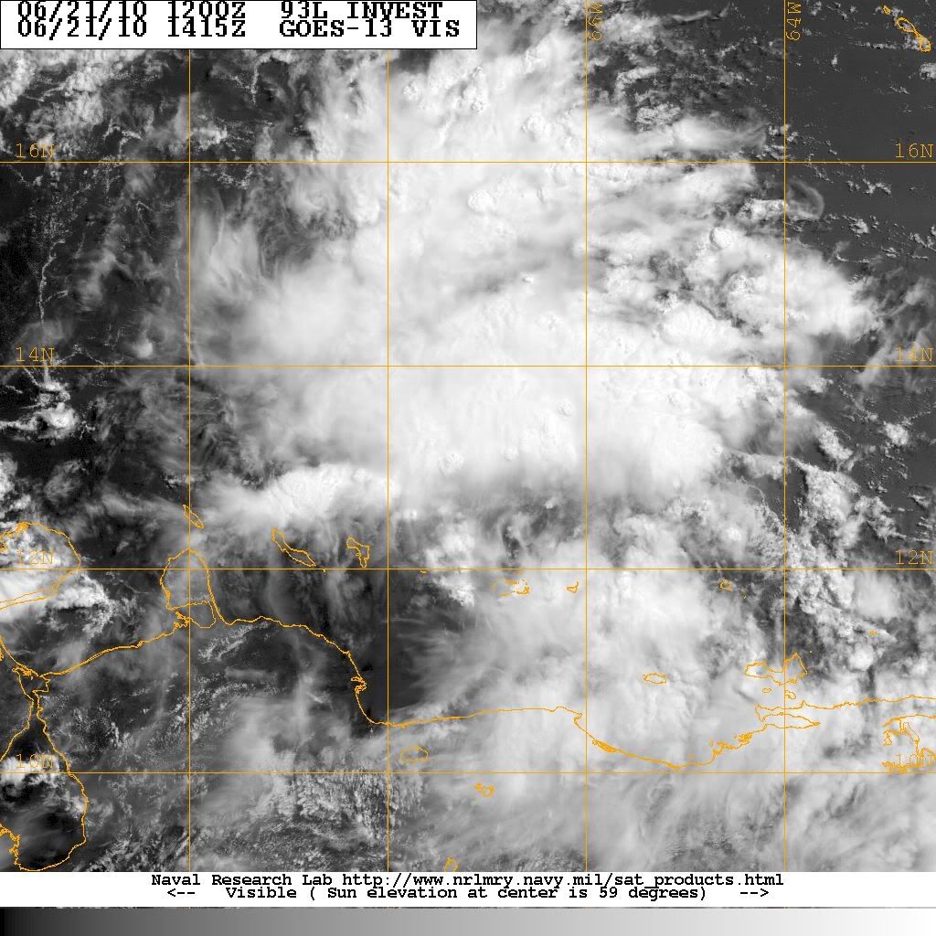
Moisture evelope looks impressive for further development...
Re: 93L Central Caribbean
Posted: Mon Jun 21, 2010 11:44 am
by srainhoutx