

Hurricane Alex. 40 Miles NNE of La Pesca. 100 MPH/948MB
-
Andrew
- Site Admin

- Posts: 3440
- Joined: Wed Feb 03, 2010 9:46 pm
- Location: North-West Houston
- Contact:
Gfs on the other hand sends it way way south hitting the Yucatan peninsula. At this point everywhere from South America to Florida looks in play. Going to be some sleepless nights ahead....
For Your Infinite Source For All Things Weather Visit Our Facebook

convection is now noticeably fading despite d-max. it needs to refire if it is to have any hope of ramping up quickly.
I think it was going to be a slow developer from the get go like most systems. What you have across the boards was the big Euro run last night combined with being probably the first legit system and many folks have looked for development a little to quickly.msp wrote:convection is now noticeably fading despite d-max. it needs to refire if it is to have any hope of ramping up quickly.
there's truth in that without a doubt, but i feel there was a sense of hope that a quicker development may have been in the cards when the fanning signature improved this afternoon and some mild mid-level turning became apparent. that said, you're right that this is probably going to wax and wane for another day or two as it passes jamaica before it begins to crank up.Scott747 wrote:I think it was going to be a slow developer from the get go like most systems. What you have across the boards was the big Euro run last night combined with being probably the first legit system and many folks have looked for development a little to quickly.
still 50%
A VIGOROUS TROPICAL WAVE EXTENDING FROM HISPANIOLA SOUTHWARD
OVER THE CENTRAL CARIBBEAN SEA IS PRODUCING WIDESPREAD CLOUDINESS
AND SHOWERS ACROSS MUCH OF THE CENTRAL AND EASTERN CARIBBEAN AND THE
ADJACENT LAND AREAS. UPPER-LEVEL WINDS APPEAR TO BE CONDUCIVE FOR
A TROPICAL DEPRESSION TO FORM DURING THE NEXT COUPLE OF DAYS. THIS
DISTURBANCE COULD PRODUCE LOCALLY HEAVY RAINFALL AND GUSTY WINDS
OVER PORTIONS OF PUERTO RICO...THE DOMINICAN REPUBLIC...
HAITI...THE NETHERLANDS ANTILLES...AND JAMAICA DURING THE NEXT DAY
OR SO AS IT MOVES WEST-NORTHWESTWARD AT 10 TO 15 MPH. THERE IS A
MEDIUM CHANCE...50 PERCENT...OF THIS SYSTEM BECOMING A TROPICAL
CYCLONE DURING THE NEXT 48 HOURS.

0z Euro is a S TX landfall again, fwiw
The storm misses the bypassing trough over the NE as 93L starts to take a more northerly track, and takes a hard turn left towards the S TX Coast as a large 594 dm+ ridge builds to the north
The storm misses the bypassing trough over the NE as 93L starts to take a more northerly track, and takes a hard turn left towards the S TX Coast as a large 594 dm+ ridge builds to the north

I know this is a long way out ... haven't been paying too close attention to the models ....... Tyler .... what timeframe does that show for the S. Texas Lanfall??
~~~When Thunder Roars Go Indoors~~~
~~~Turn Around Don't Drown~~~
~~~Run From The Water, Hide From The Wind~~~
~~~Turn Around Don't Drown~~~
~~~Run From The Water, Hide From The Wind~~~
Yeah, should've mentioned that... After day 7, or around next wednesday. Plenty of time before then for the models to flip back and forth.djjordan wrote:I know this is a long way out ... haven't been paying too close attention to the models ....... Tyler .... what timeframe does that show for the S. Texas Lanfall??
This is all just pure speculation at this point. We still do not have a defined center for this system, so expect high variability in the modeling until we actually have a developed LLC.
Yeah .... true ... we all know models have a very hard time until a LLC can develop ..... lots of time to keep watching this. I do believe this has a decent chance of becoming Alex however.
~~~When Thunder Roars Go Indoors~~~
~~~Turn Around Don't Drown~~~
~~~Run From The Water, Hide From The Wind~~~
~~~Turn Around Don't Drown~~~
~~~Run From The Water, Hide From The Wind~~~

-
srainhoutx

- Site Admin
- Posts: 19616
- Joined: Tue Feb 02, 2010 2:32 pm
- Location: Maggie Valley, NC
- Contact:
000
ABNT20 KNHC 221136
TWOAT
TROPICAL WEATHER OUTLOOK
NWS TPC/NATIONAL HURRICANE CENTER MIAMI FL
800 AM EDT TUE JUN 22 2010
FOR THE NORTH ATLANTIC...CARIBBEAN SEA AND THE GULF OF MEXICO...
A STRONG TROPICAL WAVE OVER THE CENTRAL CARIBBEAN SEA IS PRODUCING A
LARGE AREA OF DISORGANIZED SHOWERS AND THUNDERSTORMS OVER PORTIONS
OF THE CENTRAL CARIBBEAN AND THE ADJACENT LAND AREAS. UPPER-LEVEL
WINDS APPEAR TO BE CONDUCIVE FOR GRADUAL DEVELOPMENT AND A TROPICAL
DEPRESSION COULD FORM DURING THE NEXT COUPLE OF DAYS. REGARDLESS
OF DEVELOPMENT...LOCALLY HEAVY RAINFALL AND GUSTY WINDS ARE
POSSIBLE OVER PORTIONS OF PUERTO RICO...THE DOMINICAN REPUBLIC...
HAITI...AND JAMAICA DURING THE NEXT DAY OR SO AS IT MOVES
WEST-NORTHWESTWARD AT ABOUT 10 MPH. THERE IS A MEDIUM CHANCE...40
PERCENT...OF THIS SYSTEM BECOMING A TROPICAL CYCLONE DURING THE
NEXT 48 HOURS.
ELSEWHERE...TROPICAL CYCLONE FORMATION IS NOT EXPECTED DURING THE
NEXT 48 HOURS.
$$
FORECASTER BROWN/BLAKE
Carla/Alicia/Jerry(In The Eye)/Michelle/Charley/Ivan/Dennis/Katrina/Rita/Wilma/Humberto/Ike/Harvey
Member: National Weather Association
Facebook.com/Weather Infinity
Twitter @WeatherInfinity
Member: National Weather Association
Facebook.com/Weather Infinity
Twitter @WeatherInfinity
-
srainhoutx
- Site Admin
- Posts: 19616
- Joined: Tue Feb 02, 2010 2:32 pm
- Location: Maggie Valley, NC
- Contact:
Have a great vacation Ed.
Carla/Alicia/Jerry(In The Eye)/Michelle/Charley/Ivan/Dennis/Katrina/Rita/Wilma/Humberto/Ike/Harvey
Member: National Weather Association
Facebook.com/Weather Infinity
Twitter @WeatherInfinity
Member: National Weather Association
Facebook.com/Weather Infinity
Twitter @WeatherInfinity

not looking all that great this am.....just a mess with some mid-level turning. nada at the surface....model support still somewhat there....glad to see last nights GFDL backed off on the major going into the oil spill.....
Ed, dont go into "its a Small World"...you will never get it out of your head for days....
Ed, dont go into "its a Small World"...you will never get it out of your head for days....
-
srainhoutx
- Site Admin
- Posts: 19616
- Joined: Tue Feb 02, 2010 2:32 pm
- Location: Maggie Valley, NC
- Contact:
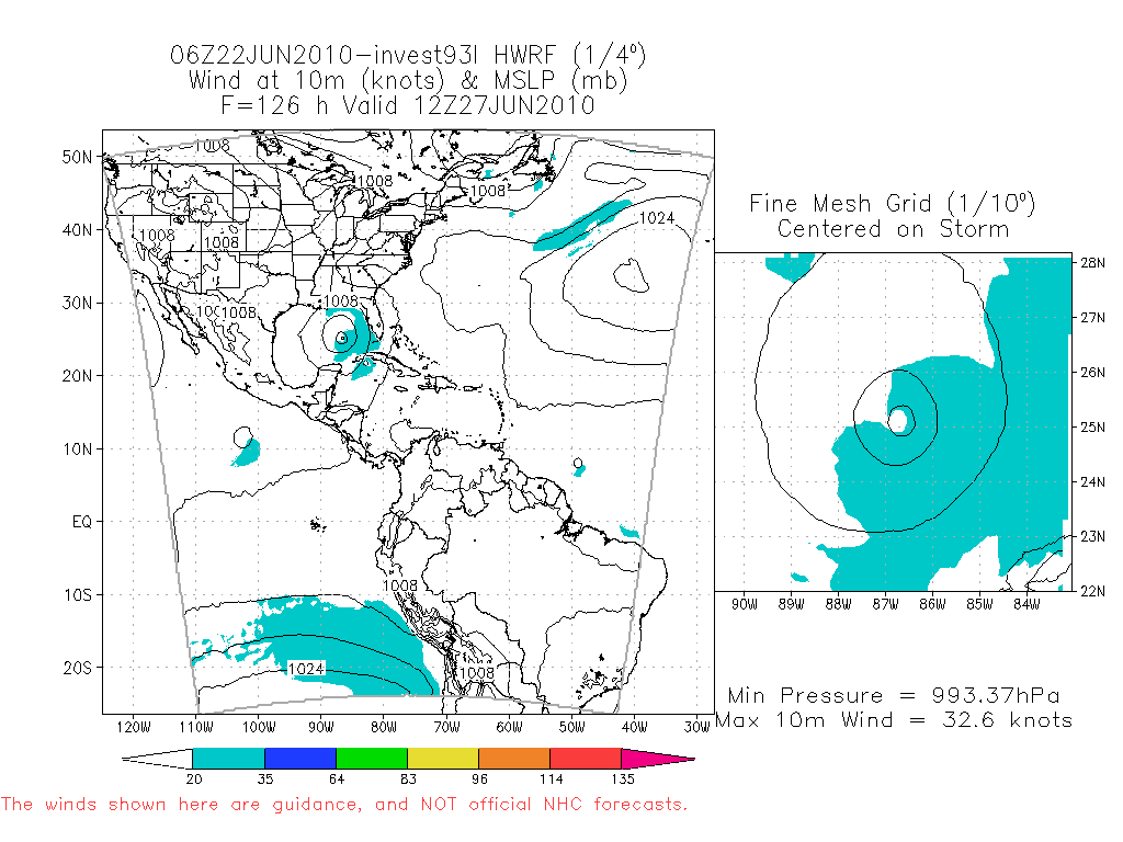
06Z HWRF suggests a weak Trpoical Storm just NW of Key West...
Carla/Alicia/Jerry(In The Eye)/Michelle/Charley/Ivan/Dennis/Katrina/Rita/Wilma/Humberto/Ike/Harvey
Member: National Weather Association
Facebook.com/Weather Infinity
Twitter @WeatherInfinity
Member: National Weather Association
Facebook.com/Weather Infinity
Twitter @WeatherInfinity
-
srainhoutx
- Site Admin
- Posts: 19616
- Joined: Tue Feb 02, 2010 2:32 pm
- Location: Maggie Valley, NC
- Contact:
Code: Select all
WHXX01 KWBC 221243
CHGHUR
TROPICAL CYCLONE GUIDANCE MESSAGE
NWS TPC/NATIONAL HURRICANE CENTER MIAMI FL
1243 UTC TUE JUN 22 2010

DISCLAIMER...NUMERICAL MODELS ARE SUBJECT TO LARGE ERRORS.
PLEASE REFER TO NHC OFFICIAL FORECASTS FOR TROPICAL CYCLONE
AND SUBTROPICAL CYCLONE INFORMATION.

ATLANTIC OBJECTIVE AIDS FOR

DISTURBANCE INVEST (AL932010) 20100622 1200 UTC

...00 HRS... ...12 HRS... ...24 HRS. .. ...36 HRS...
100622 1200 100623 0000 100623 1200 100624 0000

LAT LON LAT LON LAT LON LAT LON
BAMS 15.3N 72.3W 16.2N 74.7W 17.0N 77.1W 17.8N 79.2W
BAMD 15.3N 72.3W 16.0N 74.3W 16.6N 76.1W 16.9N 77.8W
BAMM 15.3N 72.3W 16.1N 74.5W 16.8N 76.7W 17.5N 78.7W
LBAR 15.3N 72.3W 16.2N 74.5W 17.2N 76.8W 18.0N 79.0W
SHIP 25KTS 29KTS 34KTS 42KTS
DSHP 25KTS 29KTS 34KTS 42KTS

...48 HRS... ...72 HRS... ...96 HRS. .. ..120 HRS...
100624 1200 100625 1200 100626 1200 100627 1200

LAT LON LAT LON LAT LON LAT LON
BAMS 18.3N 81.5W 19.1N 85.1W 20.0N 88.1W 21.2N 90.6W
BAMD 17.0N 79.3W 17.3N 82.6W 17.8N 85.8W 18.4N 88.9W
BAMM 17.8N 80.5W 18.2N 83.9W 19.0N 86.8W 20.0N 89.3W
LBAR 18.6N 81.0W 20.0N 84.9W 21.9N 87.9W 23.6N 89.6W
SHIP 51KTS 66KTS 80KTS 91KTS
DSHP 51KTS 66KTS 80KTS 37KTS

...INITIAL CONDITIONS...
LATCUR = 15.3N LONCUR = 72.3W DIRCUR = 285DEG SPDCUR = 12KT
LATM12 = 14.9N LONM12 = 70.0W DIRM12 = 282DEG SPDM12 = 12KT
LATM24 = 14.0N LONM24 = 67.6W
WNDCUR = 25KT RMAXWD = 60NM WNDM12 = 25KT
CENPRS = 1010MB OUTPRS = 1012MB OUTRAD = 120NM SDEPTH = S
RD34NE = 0NM RD34SE = 0NM RD34SW = 0NM RD34NW = 0NM
Carla/Alicia/Jerry(In The Eye)/Michelle/Charley/Ivan/Dennis/Katrina/Rita/Wilma/Humberto/Ike/Harvey
Member: National Weather Association
Facebook.com/Weather Infinity
Twitter @WeatherInfinity
Member: National Weather Association
Facebook.com/Weather Infinity
Twitter @WeatherInfinity

Tropical update portion of Jeff Lindner's email:
93L:
Caribbean tropical system is looking poorly organized this morning with a general overall lack of deep convection. There remains no signs of any kind of surface circulation in the surface observations, although some weak mid level turning is noted on IR images. While conditions are generally favorable for development, it will be slow and not likely until the system reaches the west-central Caribbean Sea.
Forecast models remain at odds as to where to take this system and how strong it will become. The GFS still does not even show any kind of system at all for the next 5 days. The intense ECMWF runs from yesterday have backed way off and shifted well west bringing a broad circulation toward the NW Gulf. The GFDL hurricane model looks like yesterdays ECMWF with a monster hurricane plowing toward W Cuba and then toward the east-central US Gulf coast. The HWRF hurricane model does all kinds of weird loops and turns and shows little development, so it is being tossed out. The CMC is somewhat in line with the GFDL, but much weaker and develops a strange phantom storm over S FL at the same time 93L reaches the Gulf and moves them both NNE into the NE Gulf…interesting but highly unlikely. The NOGAPS is also weak and in the same ball park as the ECMWF. Models will not get much better until a defined center forms.
Will side with the weaker and southern/western track shown by the ECMWF, GFS, and NOGAPS given the current organization and the time of year. While the GFDL is a highly respected model, it is likely making 93L too strong and hence the system feels a greater pull from a weakness over the SE US. Not sure what is up with the GFS not showing anything…or maybe it is on the right page. HPC progs with NHC coordination bring a closed low out of the western Caribbean Sea and into the SC Gulf of Mexico early next week….and I still think this is the best solution for this system.
Still much uncertainty in the forecast for the late weekend into early next week and will leave it at that for now.
06Z 93L Guidance:
Note the crazy looking HWRF track. The GFDL and HWRF and on the east side of the cluster with all the tropical models run by NHC on the far left or southern side of the cluster. CLP5 and LBAR are not forecast models, but baselines to run against.

-
srainhoutx
- Site Admin
- Posts: 19616
- Joined: Tue Feb 02, 2010 2:32 pm
- Location: Maggie Valley, NC
- Contact:

Carla/Alicia/Jerry(In The Eye)/Michelle/Charley/Ivan/Dennis/Katrina/Rita/Wilma/Humberto/Ike/Harvey
Member: National Weather Association
Facebook.com/Weather Infinity
Twitter @WeatherInfinity
Member: National Weather Association
Facebook.com/Weather Infinity
Twitter @WeatherInfinity
We were looking at a short vacation to north Houston on July 1-4 - I know it's way early and anything can happen, but I'm thinking best case we'll see some rain from this during that time frame? Sorry, not technical weather question, but I have alternatives if it looks like I'll be stuck in a hotel room with 3 kids for a few days. Thanks!