

Hurricane Alex. 40 Miles NNE of La Pesca. 100 MPH/948MB
-
Portastorm

- Posts: 800
- Joined: Wed Feb 03, 2010 3:04 pm
- Location: Southwest Austin/Oak Hill, TX
- Contact:
Currently light shear in the central Carribbean with GFS forecasting very little shear in its path over the next 48 hours. What's not to stop this thing from developing?
-
srainhoutx

- Site Admin

- Posts: 19616
- Joined: Tue Feb 02, 2010 2:32 pm
- Location: Maggie Valley, NC
- Contact:

Carla/Alicia/Jerry(In The Eye)/Michelle/Charley/Ivan/Dennis/Katrina/Rita/Wilma/Humberto/Ike/Harvey
Member: National Weather Association
Facebook.com/Weather Infinity
Twitter @WeatherInfinity
Member: National Weather Association
Facebook.com/Weather Infinity
Twitter @WeatherInfinity

I would agree with you ED...there is not evidence of something at the surface. Not many obs out there to go by and the sat view is a mess. Where is QSCAT when you need it.... 
personally, track wise it will get into the GOM, How strong it will be and where it would go next is the big question. We need more model agreement to nail this one down....
personally, track wise it will get into the GOM, How strong it will be and where it would go next is the big question. We need more model agreement to nail this one down....
BTW- I would take Wunderground posters with a grain of salt....though I love Jeff Masters some of his peeps are not the sharpest tools in the shed,,,,
Crazy early intensity runs. Should get the first hurricane suite runs in a few hours.

-
srainhoutx
- Site Admin
- Posts: 19616
- Joined: Tue Feb 02, 2010 2:32 pm
- Location: Maggie Valley, NC
- Contact:
We have a lot of Guests viewing. Welcome and if you have not signed in to become a member, we encourage you to do so and join in on the discussions!
There are 3 registered users and 1 hidden user online
There are 7 guest users online
There are 3 registered users and 1 hidden user online
There are 7 guest users online
Carla/Alicia/Jerry(In The Eye)/Michelle/Charley/Ivan/Dennis/Katrina/Rita/Wilma/Humberto/Ike/Harvey
Member: National Weather Association
Facebook.com/Weather Infinity
Twitter @WeatherInfinity
Member: National Weather Association
Facebook.com/Weather Infinity
Twitter @WeatherInfinity
Agree, but there's a few on there that do know what they're talking about. StormW is one. He's usually pretty conservative in his statements and he's concerned about the set up for 93L.Paul wrote:BTW- I would take Wunderground posters with a grain of salt....though I love Jeff Masters some of his peeps are not the sharpest tools in the shed,,,,
-
srainhoutx
- Site Admin
- Posts: 19616
- Joined: Tue Feb 02, 2010 2:32 pm
- Location: Maggie Valley, NC
- Contact:
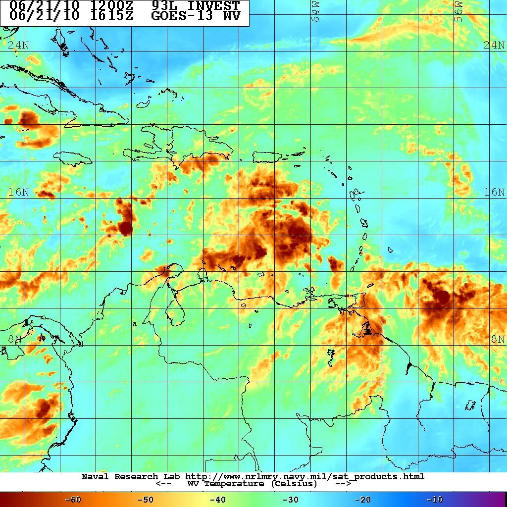
Moisture evelope looks impressive for further development...
Carla/Alicia/Jerry(In The Eye)/Michelle/Charley/Ivan/Dennis/Katrina/Rita/Wilma/Humberto/Ike/Harvey
Member: National Weather Association
Facebook.com/Weather Infinity
Twitter @WeatherInfinity
Member: National Weather Association
Facebook.com/Weather Infinity
Twitter @WeatherInfinity
-
srainhoutx
- Site Admin
- Posts: 19616
- Joined: Tue Feb 02, 2010 2:32 pm
- Location: Maggie Valley, NC
- Contact:

Carla/Alicia/Jerry(In The Eye)/Michelle/Charley/Ivan/Dennis/Katrina/Rita/Wilma/Humberto/Ike/Harvey
Member: National Weather Association
Facebook.com/Weather Infinity
Twitter @WeatherInfinity
Member: National Weather Association
Facebook.com/Weather Infinity
Twitter @WeatherInfinity
Euro has also went from STx/NMex to near Florida in the span of a few runs. Typical flip flopping with the longer range and needs to become more consistent and should do so as we shorten the range.
This is still a week or so from being a potential threat to any of the Gulf states.
This is still a week or so from being a potential threat to any of the Gulf states.
-
srainhoutx
- Site Admin
- Posts: 19616
- Joined: Tue Feb 02, 2010 2:32 pm
- Location: Maggie Valley, NC
- Contact:
Carla/Alicia/Jerry(In The Eye)/Michelle/Charley/Ivan/Dennis/Katrina/Rita/Wilma/Humberto/Ike/Harvey
Member: National Weather Association
Facebook.com/Weather Infinity
Twitter @WeatherInfinity
Member: National Weather Association
Facebook.com/Weather Infinity
Twitter @WeatherInfinity
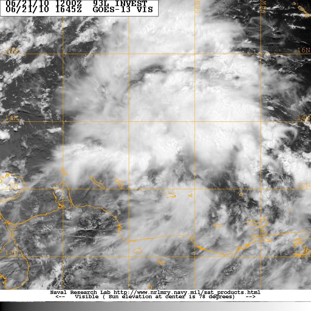
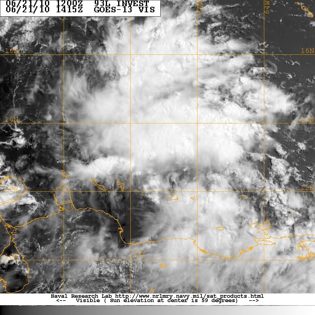
Is it me, and I promise I am not trying to be a smartie pants here as I am still learning, or does 93L seem to be looking a little more healthy this afternoon?
My name is Nicole and I love weather!!
~~~~~~~~~~~~~~~~~~~~~~~~~~~~~~~~~~~~~~~~~~~~~~~~~~~~~~~~~~~~~~~~~~~~~~~~~~~~~~~~~~~~~~~~~~~~~~~~
Alicia, Allison, Rita, Ike
~~~~~~~~~~~~~~~~~~~~~~~~~~~~~~~~~~~~~~~~~~~~~~~~~~~~~~~~~~~~~~~~~~~~~~~~~~~~~~~~~~~~~~~~~~~~~~~~
Alicia, Allison, Rita, Ike

In a hurry so I don't have time to mince words:
Favorable shear - check
Ridge overhead forecasted to build W with the system - check
Favorbale SSTs - check
Favorable MJO - check
Large Moisture Envelope - check
Model support for development - check (forget the GFS for now)
I think we will see Alex out of this. Not buying the latest Euro track. This one needs to be watched...we have late summer SSTs in the GOM with a ridge to the north.
Early HWRF run @ 42 hrs -

-
Hardcoreweather
2pm
000
ABNT20 KNHC 211748
TWOAT
TROPICAL WEATHER OUTLOOK
NWS TPC/NATIONAL HURRICANE CENTER MIAMI FL
200 PM EDT MON JUN 21 2010
FOR THE NORTH ATLANTIC...CARIBBEAN SEA AND THE GULF OF MEXICO...
#5
A LARGE AREA OF SHOWERS AND THUNDERSTORMS OVER THE EASTERN CARIBBEAN
SEA IS ASSOCIATED WITH A STRONG TROPICAL WAVE THAT IS MOVING
WESTWARD AT 10 TO 15 MPH. ALTHOUGH THERE IS NO EVIDENCE OF A
SURFACE CIRCULATION...THIS SYSTEM IS SHOWING SOME SIGNS OF
ORGANIZATION AND ENVIRONMENTAL CONDITIONS APPEAR CONDUCIVE FOR
GRADUAL DEVELOPMENT DURING THE NEXT COUPLE OF DAYS. THIS WAVE
COULD PRODUCE LOCALLY HEAVY RAINFALL AND GUSTY WINDS OVER PORTIONS
OF NORTHERN VENEZUELA...THE NETHERLANDS ANTILLES...PUERTO
RICO...THE DOMINICAN REPUBLIC...AND HAITI OVER THE NEXT DAY OR SO.
THERE IS A MEDIUM CHANCE...30 PERCENT...OF THIS SYSTEM BECOMING A
TROPICAL CYCLONE DURING THE NEXT 48 HOURS.
ELSEWHERE...TROPICAL CYCLONE FORMATION IS NOT EXPECTED DURING THE
NEXT 48 HOURS.
$$
FORECASTER BLAKE

30% now...
-
srainhoutx
- Site Admin
- Posts: 19616
- Joined: Tue Feb 02, 2010 2:32 pm
- Location: Maggie Valley, NC
- Contact:
Hardcoreweather wrote:2pm
000
ABNT20 KNHC 211748
TWOAT
TROPICAL WEATHER OUTLOOK
NWS TPC/NATIONAL HURRICANE CENTER MIAMI FL
200 PM EDT MON JUN 21 2010
FOR THE NORTH ATLANTIC...CARIBBEAN SEA AND THE GULF OF MEXICO...
#5
A LARGE AREA OF SHOWERS AND THUNDERSTORMS OVER THE EASTERN CARIBBEAN
SEA IS ASSOCIATED WITH A STRONG TROPICAL WAVE THAT IS MOVING
WESTWARD AT 10 TO 15 MPH. ALTHOUGH THERE IS NO EVIDENCE OF A
SURFACE CIRCULATION...THIS SYSTEM IS SHOWING SOME SIGNS OF
ORGANIZATION AND ENVIRONMENTAL CONDITIONS APPEAR CONDUCIVE FOR
GRADUAL DEVELOPMENT DURING THE NEXT COUPLE OF DAYS. THIS WAVE
COULD PRODUCE LOCALLY HEAVY RAINFALL AND GUSTY WINDS OVER PORTIONS
OF NORTHERN VENEZUELA...THE NETHERLANDS ANTILLES...PUERTO
RICO...THE DOMINICAN REPUBLIC...AND HAITI OVER THE NEXT DAY OR SO.
THERE IS A MEDIUM CHANCE...30 PERCENT...OF THIS SYSTEM BECOMING A
TROPICAL CYCLONE DURING THE NEXT 48 HOURS.
ELSEWHERE...TROPICAL CYCLONE FORMATION IS NOT EXPECTED DURING THE
NEXT 48 HOURS.
$$
FORECASTER BLAKE
Carla/Alicia/Jerry(In The Eye)/Michelle/Charley/Ivan/Dennis/Katrina/Rita/Wilma/Humberto/Ike/Harvey
Member: National Weather Association
Facebook.com/Weather Infinity
Twitter @WeatherInfinity
Member: National Weather Association
Facebook.com/Weather Infinity
Twitter @WeatherInfinity
-
srainhoutx
- Site Admin
- Posts: 19616
- Joined: Tue Feb 02, 2010 2:32 pm
- Location: Maggie Valley, NC
- Contact:
Decent development in a few hours...
Carla/Alicia/Jerry(In The Eye)/Michelle/Charley/Ivan/Dennis/Katrina/Rita/Wilma/Humberto/Ike/Harvey
Member: National Weather Association
Facebook.com/Weather Infinity
Twitter @WeatherInfinity
Member: National Weather Association
Facebook.com/Weather Infinity
Twitter @WeatherInfinity
Jeff Lindner's update:
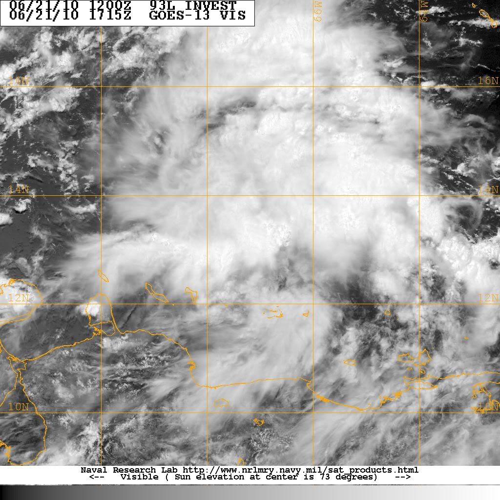
Strong tropical wave over the east-central Caribbean Sea is becoming better organized.
Visible satellite images show numerous developing convective clusters, but as of yet no well defined surface circulation. Moist envelop surrounds this system of interest and strong shear in the Caribbean will be weakening over the next 24-48 hours allowing the development of favorable upper air conditions. NHC has risen the threat of TX development in the next 48 hours into the 30-50%. Conditions only get better aloft and at the surface as the system heads for the western Caribbean Sea by the end of the week.
Intensity guidance is very aggressive with this system, with SHIPS taking it well into a hurricane by days 4 and 5 which is very aggressive for a June tropical system…but it has happened before. Gulf water temperatures are now running in the low to mid 80’s and are more than warm enough to support a tropical cyclone. Models are forecasting the development of an anticyclone aloft over the system as it enters the Gulf, so conditions do look ripe for intensification.
Model guidance remains inconsistent on the potential track with various possibilities playing out. CMC and EURO are strongest and show a weakness in the southern US ridge over the central Gulf states allowing the system to gradually recurve into the eastern Gulf coast. The GFS is still showing no development at all…which is really strange for this model along with the UKMET. The NOGAPS shows a weaker system sliding WNW into the western Gulf of Mexico. Way too early to tell either way with anything.
Recon aircraft is tasked to investigate if needed on Wednesday