

UK Ensembles:
https://www.americanwx.com/bb/applicati ... aeddd33958
Be prepared!
September 2019 - Warm End of September
Mandatory evacuations for Gold Coast of Florida.
https://www.miamiherald.com/news/weathe ... 14387.html
https://www.miamiherald.com/news/weathe ... 14387.html


Jeff e-mail from this morning.
“Tropical wave over the Gulf of Mexico continues to slowly move westward this morning with little change in organization. Global forecast models continue to suggest the broad area of low pressure associated with this feature may have some more additional development over the next 2-3 days as the system reaches the west and southwest Gulf of Mexico. NHC currently gives the system a 30% chance of development. With high pressure building from the four corners area today into the southern plains by Tuesday the W to WSW steering flow on the southern side of this high will keep the wave axis and broad low pressure south of TX and aimed at the eastern coast of MX. Strong subsidence will be developing over much of TX by Tuesday, and while deep tropical moisture associated with this feature will move toward the TX coast, the orientation of the high pressure and sinking air over the region will likely keep most of the showers and thunderstorms off the coast and over the Gulf waters.
The potential for the development of other systems over the Atlantic basin currently pose no threat to the Gulf of Mexico.”


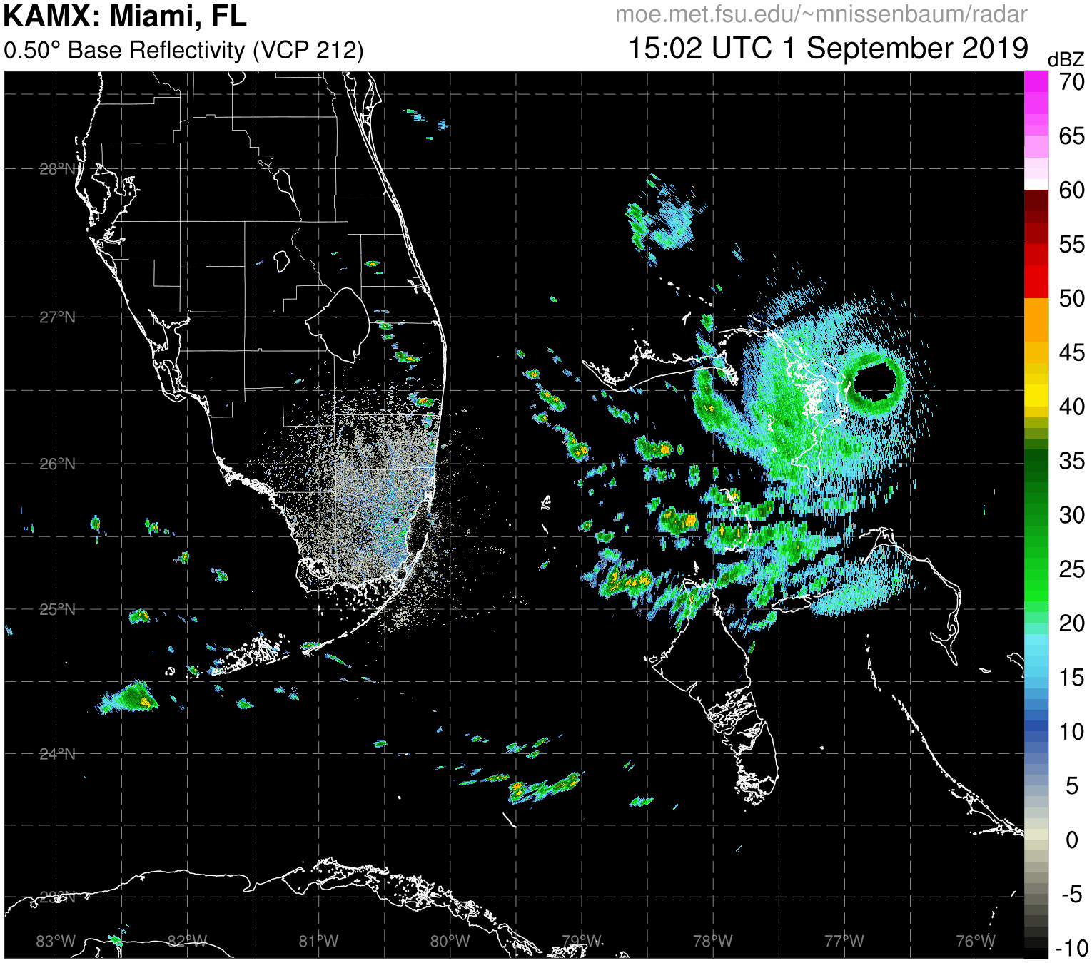
Doppler radar out of Bahamas.
http://smartmet.bahamasweather.org.bs/radarcomposite/
A very frightening sight.


http://smartmet.bahamasweather.org.bs/radarcomposite/
A very frightening sight.
Last edited by Ptarmigan on Sun Sep 01, 2019 10:55 am, edited 1 time in total.
Wow, that is terrible
I am surprised the weather station is still working.
Current Weather For Hope Town.
https://www.wunderground.com/weather/bs/hope-town
It has 163 mph and is on the western edge of Dorian.
Looks like landfall is about to happen.
Rip76 wrote: ↑Sun Sep 01, 2019 10:46 am Jeff e-mail from this morning.
“Tropical wave over the Gulf of Mexico continues to slowly move westward this morning with little change in organization. Global forecast models continue to suggest the broad area of low pressure associated with this feature may have some more additional development over the next 2-3 days as the system reaches the west and southwest Gulf of Mexico. NHC currently gives the system a 30% chance of development. With high pressure building from the four corners area today into the southern plains by Tuesday the W to WSW steering flow on the southern side of this high will keep the wave axis and broad low pressure south of TX and aimed at the eastern coast of MX. Strong subsidence will be developing over much of TX by Tuesday, and while deep tropical moisture associated with this feature will move toward the TX coast, the orientation of the high pressure and sinking air over the region will likely keep most of the showers and thunderstorms off the coast and over the Gulf waters.
The potential for the development of other systems over the Atlantic basin currently pose no threat to the Gulf of Mexico.”
Thanks Rip76.
Live video from Marsh Harbor. I would not want to be caught in it for sure.
https://www.youtube.com/watch?v=6RuhYgn41ms
https://www.youtube.com/watch?v=6RuhYgn41ms
-
TexasBreeze
- Posts: 942
- Joined: Sun Sep 26, 2010 4:46 pm
- Location: NW Houston, TX
- Contact:
It still appears to be strengthening according to each recon pass and the radar presentation is truely perfect and as astounding as can get.
Code: Select all
KeviShader
@KeviShader
Follow Follow @KeviShader
More
New recon pass shows 909mb extrapolated and still relatively strong winds so the new pressure is likely ~908mb or so.
This thing is intensifying 5mb per pass!!!!
#Dorian
8:31 AM - 1 Sep 2019Pressure is still dropping. No eyewall replacement cycle yet.
Last edited by Ptarmigan on Sun Sep 01, 2019 11:08 am, edited 1 time in total.
-
srainhoutx

- Site Admin

- Posts: 19616
- Joined: Tue Feb 02, 2010 2:32 pm
- Location: Maggie Valley, NC
- Contact:
Josh MorgermanVerified account @iCyclone · 11m11 minutes ago
11:40 am. Pounding. CRASHING. Boards prying off windows. We're moving children to a safe space, wrapping them in blankets. 969 mg. #DORIAN
11:40 am. Pounding. CRASHING. Boards prying off windows. We're moving children to a safe space, wrapping them in blankets. 969 mg. #DORIAN
Carla/Alicia/Jerry(In The Eye)/Michelle/Charley/Ivan/Dennis/Katrina/Rita/Wilma/Humberto/Ike/Harvey
Member: National Weather Association
Facebook.com/Weather Infinity
Twitter @WeatherInfinity
Member: National Weather Association
Facebook.com/Weather Infinity
Twitter @WeatherInfinity
Canadian starting the turn on 12z just off the coast.
-
Texaspirate11

- Posts: 1278
- Joined: Tue Dec 31, 2013 12:24 am
- Contact:
180 mph poor Bahamas
Just because you're disabled, you don't have to be a victim
Be Weather Aware & Prepared!
Barbara Jordan Winner in Media
Disability Integration Consultant
Be Weather Aware & Prepared!
Barbara Jordan Winner in Media
Disability Integration Consultant
907 mb pressure
In the eye.
