I noticed TWC has been relying a lot on the new GFS. Omega block? ...or not. We're traveling way up north, and the forecast has been undergoing huge "mood swings" the past few days. lol We're getting close to NOOA range. Euro, CNC. Legacy should come to an agreement soon.
Area Forecast Discussion
National Weather Service Houston/Galveston TX
1039 AM CDT Thu Aug 15 2019
.SHORT TERM [Tonight Through Saturday]...
Surface analysis has rather diffuse frontal boundary stalled
across SE Texas with an outflow boundary out in the Gulf
supporting scattered showers and storms. Overall expectation is
for a few showers and storms to start initiating with daytime
heating. 500mb heights are a little lower today and there is still
a good slug of 2 inch PWAT airmass south of the stalled front and
in the vicinity of the outflow boundary. These conditions should
be favorable for more showers and storms to form. Latest HRRR and
WRF runs seem to support this idea as the stalled front could
become a focus for storms.
Overpeck
&&
.PREV DISCUSSION /Issued 600 AM CDT Thu Aug 15 2019/...
.AVIATION...
VFR. Few to Sct 3-5k ft cu with a sct ci deck. Higher threat for
isolated pop up morning showers transitioning to warmth-of-the-
afternoon storms generally closer to the coast. Festering daytime
convection (-TSRA or SHRA) may even work its way as far north as
HOU or IAH, but many inland terminals will likely remain dry
through the period. A weak northerly breeze will slowly veer east
to southeast through early Friday. 31
Scott747 wrote: ↑Thu Aug 15, 2019 5:54 am
Both the euro and GFS are now on the same page. Both have the disturbance that will be coming thru the caribbean waiting till it's in the BoC before trying to organize. Looks like a weak ts around corpus sometime next weekend. Sure there will be further differences but we're closing in on a window to take a potential threat more seriously...
I totally agree it's becoming increasingly possible that see may a tropical system in the GOM going into next weekend.
Some cells now popping in northern Montgomery County, moving south. Please please hold together and give me some rain - I tried to water this morning and only two zones out of 8 came on!! If I don’t get any rain I’ll have to water the old fashioned way until I can fix my control valves.
Cromagnum wrote: ↑Thu Aug 15, 2019 3:33 pm
Repeat of yesterday on tap? Radar is firing up the same way.
Yeah a repeat of me getting shafted again!! The storms south of Conroe are just falling apart as they approach my neighborhood — at 3:30 in the afternoon, when they should be building-up — like sick joke.
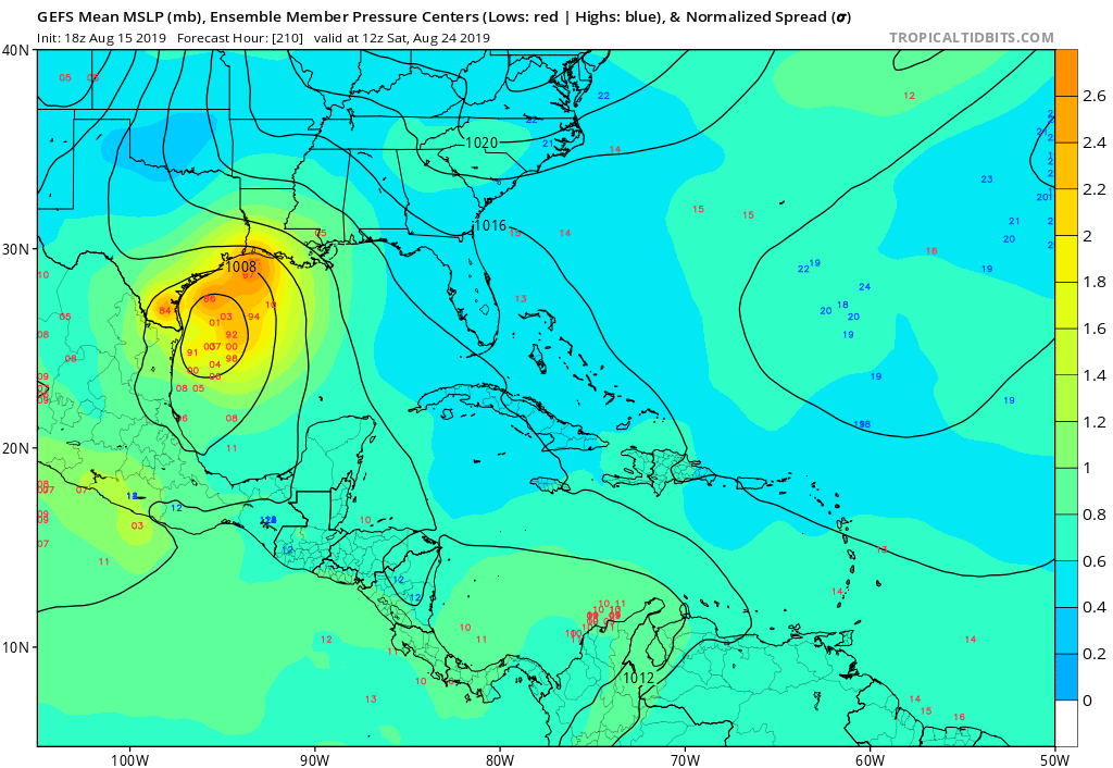
For those watching the tropics, the 12Z GEFS/Euro Ensembles do suggest some potential mischief possibly attempting to develop in the SW/Western Caribbean in about 5 days and possibly moving generally NW to near the Yucatan Peninsula/Bay of Campeche later next week. The spread among the individual ensemble members are very large (Tampico to Tampa) with a somewhat cluster of members focused along the Upper Texas Coast to Mobile. The surface charts do suggest a tropical wave will be moving in near that timeframe as well as a favorable Convectively Coupled Kelvin Wave arriving from the Eastern Pacific. The Caribbean Sea is hostile right now with West and SW wind shear, but as the CCKW moves further into the Western Atlantic Basin the hostile upper levels winds may collapse. There isn't a vigorous tropical wave that we can really 'look to' on satellite today, so we are depending on the various computer schemes for possible tropical mischief brewing sometime next week.
Carla/Alicia/Jerry(In The Eye)/Michelle/Charley/Ivan/Dennis/Katrina/Rita/Wilma/Humberto/Ike/Harvey
Member: National Weather Association
Facebook.com/Weather Infinity
Twitter @WeatherInfinity
srainhoutx wrote: ↑Thu Aug 15, 2019 5:02 pm
For those watching the tropics, the 12Z GEFS/Euro Ensembles do suggest some potential mischief possibly attempting to develop in the SW/Western Caribbean in about 5 days and possibly moving generally NW to near the Yucatan Peninsula/Bay of Campeche later next week. The spread among the individual ensemble members are very large (Tampico to Tampa) with a somewhat cluster of members focused along the Upper Texas Coast to Mobile. The surface charts do suggest a tropical wave will be moving in near that timeframe as well as a favorable Convectively Coupled Kelvin Wave arriving from the Eastern Pacific. The Caribbean Sea is hostile right now with West and SW wind shear, but as the CCKW moves further into the Western Atlantic Basin the hostile upper levels winds may collapse. There isn't a vigorous tropical wave that we can really 'look to' on satellite today, so we are depending on the various computer schemes for possible tropical mischief brewing sometime next week.
08152019 Day 5 SC 9lhwbg_conus.gif
08152019 Day 6 SC 9mhwbg_conus.gif
08152019 Day 7 SC 9nhwbg_conus.gif
08152019 CCKW twc_mjoCCKW_vp200.png
If something does develop we need it to stay weak and move into south TX so that way everyone gets in on the action. Upper TX coast would be no bueno.