
July 2019: Warming Trend/Slight Chances For Rain
This has got to be one of the weirdest storms I have ever seen.
I don't know folks, looking at radar I don't see Barry turning north at all and I'm pretty sure that turn was expected awhile ago... Seems to be hugging the coast and heading slowly west to me. Just radar casting.
Agreed. It’s mid July and Gulf storms are usually odd balls but generally predictable. This one is quite strange indeed. Having said that, it may look completely different once the sun comes up. It’s sit and watch time
A outer band is trying to form through texas and louisiana
- Attachments
-
skidog48


Night time tends to have most changes to tropical cyclones.
Many hurricanes that undergo rapid intensification happen at night.
I am not suggesting Barry is going to do that.
-
Kingwood36
- Posts: 1592
- Joined: Sat Dec 29, 2018 10:29 am
- Location: Freeport
- Contact:

This thing is a mess.

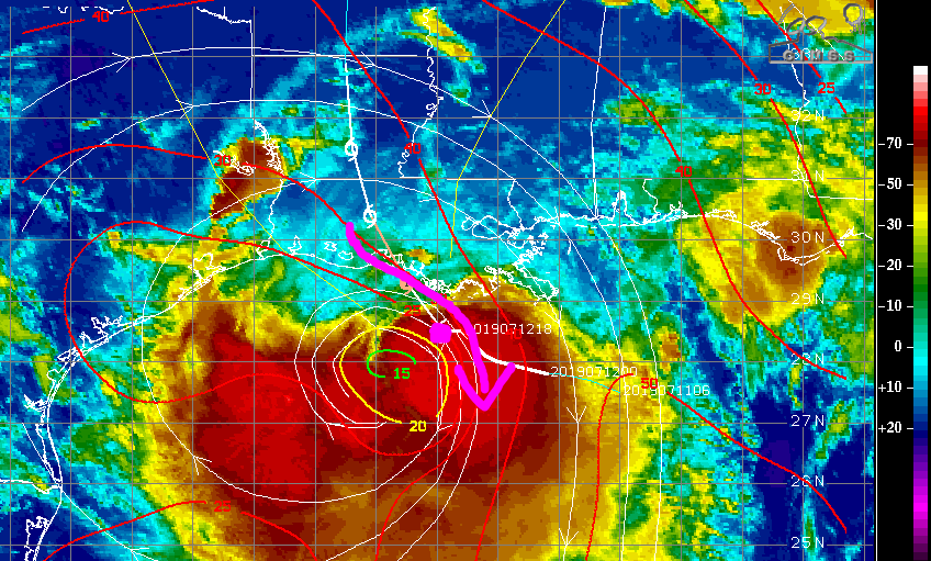
Yeah, the CoC is completely outside the mitotic convection. Incredibly weak NE side with shear. So disorganized and chopped off that steering current have not drawn Barry north yet.
CoC is SSE of Lafayette, past Morgan City and nearly due south of Franklin. The convection is literally being pulled in two.
https://www.windy.com/?29.511,-91.682,11
The models are consistent in sending Barry up the chute between the 2 highs - north.
Last edited by DoctorMu on Sat Jul 13, 2019 1:13 am, edited 1 time in total.
in other news, from the HGX AFD: https://www.weather.gov/hgx/
.CLIMATE...
It was hot yesterday. Offshore winds always bring very warm
temperatures to the coast during summer and Palacios reached 100
degrees and that ties for it's 12th warmest temperature all time.
Galveston tied it's record high of 96 degrees which was set all
the way back in 1876. Galveston also set a new high minimum
temperature record for the day with a low of 85 degrees. It also
tied it's warmest ALL-TIME overnight low temperature of 85
degrees set on June 23 2019. And, not to be left out, Houston
Hobby also established a new record high minimum temperature
record with a low of 83 degrees. This is a new high minimum record
for the day, but also for the month of July and ties for it's
warmest ALL-TIME minimum temperature set on June 23 2019. 43
-
srainhoutx

- Site Admin

- Posts: 19616
- Joined: Tue Feb 02, 2010 2:32 pm
- Location: Maggie Valley, NC
- Contact:
Barry is hardly moving and appears to be mostly drifting to the WNW or NW to the S of Abbeville and Lafayette. We are suppose to have one last RECON mission by our AF 53rd friends shortly, but no sign of the C-130J in the air. Observations due indicate some gusts to Hurricane force offshore, but Northwesterly wind shear has certainly hampered Barry throughout the past 24 hours. Locally, I continue to see signs of a rather potent feeder band setting up over SE Texas tomorrow and probably Monday. There are some indications that the remnants of Barry may be slower to exit our East Texas/West Louisiana Region than currently forecast. Barry will likely be remembered for its heavy rainfall/flooding.
- Attachments
-
-
-
Carla/Alicia/Jerry(In The Eye)/Michelle/Charley/Ivan/Dennis/Katrina/Rita/Wilma/Humberto/Ike/Harvey
Member: National Weather Association
Facebook.com/Weather Infinity
Twitter @WeatherInfinity
Member: National Weather Association
Facebook.com/Weather Infinity
Twitter @WeatherInfinity
NOAA Tides and Currents, "Quick Look" for Barry
https://tidesandcurrents.noaa.gov/inund ... Barry.html
Product Description
Inundation Dashboard provides real-time and historic coastal flooding information at a majority of coastal water level stations operated by the National Ocean Service (NOS) Center for Operational Oceanographic Products & Services (CO-OPS). The product features both a map based view where users can easily view coastal flooding information geospatially and a more detailed station view where real-time and historical data for a specific location are highlighted.
in the air http://hurricanecity.com/recon/srainhoutx wrote: ↑Sat Jul 13, 2019 6:15 am ... We are suppose to have one last RECON mission by our AF 53rd friends shortly, but no sign of the C-130J in the air.
latest obs for AF304 http://hurricanecity.com/recon/recon.cg ... page=AF304
-
srainhoutx
- Site Admin
- Posts: 19616
- Joined: Tue Feb 02, 2010 2:32 pm
- Location: Maggie Valley, NC
- Contact:
BULLETIN
TROPICAL STORM BARRY INTERMEDIATE ADVISORY NUMBER 12A
NWS NATIONAL HURRICANE CENTER MIAMI FL AL022019
700 AM CDT SAT JUL 13 2019
...BARRY GETS A LITTLE STRONGER AS IT NEARS THE LOUISIANA COAST...
...DANGEROUS STORM SURGE, HEAVY RAINS, AND WIND CONDITIONS
EXPECTED ACROSS THE NORTH-CENTRAL GULF COAST...
SUMMARY OF 700 AM CDT...1200 UTC...INFORMATION
----------------------------------------------
LOCATION...29.3N 91.9W
ABOUT 50 MI...80 KM WSW OF MORGAN CITY LOUISIANA
ABOUT 60 MI...95 KM S OF LAFAYETTE LOUISIANA
MAXIMUM SUSTAINED WINDS...70 MPH...115 KM/H
PRESENT MOVEMENT...NW OR 305 DEGREES AT 5 MPH...7 KM/H
MINIMUM CENTRAL PRESSURE...991 MB...29.26 INCHES
Carla/Alicia/Jerry(In The Eye)/Michelle/Charley/Ivan/Dennis/Katrina/Rita/Wilma/Humberto/Ike/Harvey
Member: National Weather Association
Facebook.com/Weather Infinity
Twitter @WeatherInfinity
Member: National Weather Association
Facebook.com/Weather Infinity
Twitter @WeatherInfinity
-
srainhoutx
- Site Admin
- Posts: 19616
- Joined: Tue Feb 02, 2010 2:32 pm
- Location: Maggie Valley, NC
- Contact:
"Center" may be onshore in the Western Vermillion Bay area, but who knows if it's an eddy or one of several meso vorts rotating around
- Attachments
-
Carla/Alicia/Jerry(In The Eye)/Michelle/Charley/Ivan/Dennis/Katrina/Rita/Wilma/Humberto/Ike/Harvey
Member: National Weather Association
Facebook.com/Weather Infinity
Twitter @WeatherInfinity
Member: National Weather Association
Facebook.com/Weather Infinity
Twitter @WeatherInfinity
https://twitter.com/NHC_Atlantic/status ... 4121177088
NHC Director Ken Graham will be discussing Tropical Storm #Barry on Facebook Live at 7:30 AM CDT: https://www.facebook.com/NWSNHC/
NHC Director Ken Graham will be discussing Tropical Storm #Barry on Facebook Live at 7:30 AM CDT: https://www.facebook.com/NWSNHC/


Looking at visible and radar, sure looks like Barry is inland: NW of Vermilion Bay heading NW. If you are SW of Lafayette and just waking up, probably wouldn't believe a strong TS (maybe Hurricane?) would be just a few miles from you with relatively dry conditions with maybe some sprinkles. Barry has been an odd storm and I'll be glad when it is finally dead and gone. Good riddance on this one...
Blake
Boomer Sooner
Boomer Sooner