
INVEST 92L
-
srainhoutx

- Site Admin

- Posts: 19619
- Joined: Tue Feb 02, 2010 2:32 pm
- Location: Maggie Valley, NC
- Contact:
About time for 'Bones' to make an appearance...
Carla/Alicia/Jerry(In The Eye)/Michelle/Charley/Ivan/Dennis/Katrina/Rita/Wilma/Humberto/Ike/Harvey
Member: National Weather Association
Facebook.com/Weather Infinity
Twitter @WeatherInfinity
Member: National Weather Association
Facebook.com/Weather Infinity
Twitter @WeatherInfinity
-
srainhoutx
- Site Admin
- Posts: 19619
- Joined: Tue Feb 02, 2010 2:32 pm
- Location: Maggie Valley, NC
- Contact:
ftp://ftp.tpc.ncep.noaa.gov/atcf/tcweb/Ed Mahmoud wrote:
Whats the web site wher eone can see if the have officially deactivated this as an invest yet?
Carla/Alicia/Jerry(In The Eye)/Michelle/Charley/Ivan/Dennis/Katrina/Rita/Wilma/Humberto/Ike/Harvey
Member: National Weather Association
Facebook.com/Weather Infinity
Twitter @WeatherInfinity
Member: National Weather Association
Facebook.com/Weather Infinity
Twitter @WeatherInfinity
-
srainhoutx
- Site Admin
- Posts: 19619
- Joined: Tue Feb 02, 2010 2:32 pm
- Location: Maggie Valley, NC
- Contact:
TROPICAL WEATHER OUTLOOK
NWS TPC/NATIONAL HURRICANE CENTER MIAMI FL
800 PM EDT WED JUN 16 2010
FOR THE NORTH ATLANTIC...CARIBBEAN SEA AND THE GULF OF MEXICO...
SATELLITE IMAGERY AND BUOY OBSERVATIONS INDICATE THAT THE LOW
PRESSURE AREA LOCATED ABOUT 550 MILES EAST OF THE LESSER ANTILLES
HAS WEAKENED TO A TROPICAL WAVE. IN ADDITION... THE ASSOCIATED
SHOWER ACTIVITY HAS DECREASED. UPPER-LEVEL WINDS ARE EXPECTED TO
REMAIN UNFAVORABLE FOR TROPICAL CYCLONE FORMATION...AND THERE IS A
LOW CHANCE...NEAR 0 PERCENT...OF THIS SYSTEM BECOMING A TROPICAL
CYCLONE DURING THE NEXT 48 HOURS AS IT MOVES WEST-NORTHWESTWARD
NEAR 15 MPH.
ELSEWHERE...TROPICAL CYCLONE FORMATION IS NOT EXPECTED DURING THE
NEXT 48 HOURS.
$$
FORECASTER CANGIALOSI/BEVEN
Carla/Alicia/Jerry(In The Eye)/Michelle/Charley/Ivan/Dennis/Katrina/Rita/Wilma/Humberto/Ike/Harvey
Member: National Weather Association
Facebook.com/Weather Infinity
Twitter @WeatherInfinity
Member: National Weather Association
Facebook.com/Weather Infinity
Twitter @WeatherInfinity

yep 92L went the way of Chris in 2006....nothing left really.....I sitll say this was a TD a few days ago....
NEXT....
NEXT....
-
srainhoutx
- Site Admin
- Posts: 19619
- Joined: Tue Feb 02, 2010 2:32 pm
- Location: Maggie Valley, NC
- Contact:
Interesting to see the 12Z GFS suggesting that 92L or what is left of the wave will approach the FL Straits (hour 132) and end up in the Central GOM (hour 168).
Carla/Alicia/Jerry(In The Eye)/Michelle/Charley/Ivan/Dennis/Katrina/Rita/Wilma/Humberto/Ike/Harvey
Member: National Weather Association
Facebook.com/Weather Infinity
Twitter @WeatherInfinity
Member: National Weather Association
Facebook.com/Weather Infinity
Twitter @WeatherInfinity
-
srainhoutx
- Site Admin
- Posts: 19619
- Joined: Tue Feb 02, 2010 2:32 pm
- Location: Maggie Valley, NC
- Contact:
The wave that will not give up...

ABNT20 KNHC 171736
TWOAT
TROPICAL WEATHER OUTLOOK
NWS TPC/NATIONAL HURRICANE CENTER MIAMI FL
200 PM EDT THU JUN 17 2010
FOR THE NORTH ATLANTIC...CARIBBEAN SEA AND THE GULF OF MEXICO...
A STRONG TROPICAL WAVE APPROACHING THE LEEWARD ISLANDS IS PRODUCING
DISORGANIZED SHOWERS AND THUNDERSTORMS AS IT MOVES TO THE
WEST-NORTHWEST AT ABOUT 15 MPH. ALTHOUGH STRONG UPPER-LEVEL WINDS
SHOULD PREVENT TROPICAL CYCLONE FORMATION...LOCALLY HEAVY RAIN AND
GUSTY WINDS ARE POSSIBLE IN THE LEEWARD ISLANDS AND PUERTO RICO
OVER THE NEXT DAY OR TWO. THERE IS A LOW CHANCE...NEAR 0
PERCENT...OF THIS SYSTEM BECOMING A TROPICAL CYCLONE DURING THE
NEXT 48 HOURS.
TROPICAL CYCLONE FORMATION IS NOT EXPECTED DURING THE NEXT 48 HOURS.
$$
FORECASTER BLAKE
Carla/Alicia/Jerry(In The Eye)/Michelle/Charley/Ivan/Dennis/Katrina/Rita/Wilma/Humberto/Ike/Harvey
Member: National Weather Association
Facebook.com/Weather Infinity
Twitter @WeatherInfinity
Member: National Weather Association
Facebook.com/Weather Infinity
Twitter @WeatherInfinity
-
srainhoutx
- Site Admin
- Posts: 19619
- Joined: Tue Feb 02, 2010 2:32 pm
- Location: Maggie Valley, NC
- Contact:
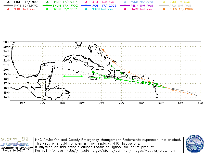
WHXX01 KWBC 171831
CHGHUR
TROPICAL CYCLONE GUIDANCE MESSAGE
NWS TPC/NATIONAL HURRICANE CENTER MIAMI FL
1831 UTC THU JUN 17 2010
DISCLAIMER...NUMERICAL MODELS ARE SUBJECT TO LARGE ERRORS.
PLEASE REFER TO NHC OFFICIAL FORECASTS FOR TROPICAL CYCLONE
AND SUBTROPICAL CYCLONE INFORMATION.
ATLANTIC OBJECTIVE AIDS FOR
DISTURBANCE INVEST (AL922010) 20100617 1800 UTC
...00 HRS... ...12 HRS... ...24 HRS. .. ...36 HRS...
100617 1800 100618 0600 100618 1800 100619 0600
LAT LON LAT LON LAT LON LAT LON
BAMS 16.0N 58.5W 16.5N 61.5W 17.1N 64.4W 17.3N 67.2W
BAMD 16.0N 58.5W 16.5N 59.7W 16.9N 61.0W 17.1N 62.4W
BAMM 16.0N 58.5W 16.4N 60.7W 17.0N 62.8W 17.2N 64.8W
LBAR 16.0N 58.5W 16.4N 60.8W 17.1N 63.5W 17.7N 66.2W
SHIP 25KTS 23KTS 22KTS 22KTS
DSHP 25KTS 23KTS 22KTS 22KTS
...48 HRS... ...72 HRS... ...96 HRS. .. ..120 HRS...
100619 1800 100620 1800 100621 1800 100622 1800
LAT LON LAT LON LAT LON LAT LON
BAMS 17.8N 70.1W 18.2N 75.5W 18.5N 80.1W 18.5N 84.4W
BAMD 17.3N 63.8W 17.8N 67.1W 19.2N 69.9W 20.7N 72.5W
BAMM 17.4N 66.9W 17.9N 71.0W 18.6N 74.3W 19.5N 77.2W
LBAR 18.3N 69.1W 19.9N 74.1W 22.1N 77.3W 23.1N 78.9W
SHIP 24KTS 26KTS 35KTS 49KTS
DSHP 24KTS 26KTS 30KTS 44KTS
...INITIAL CONDITIONS...
LATCUR = 16.0N LONCUR = 58.5W DIRCUR = 280DEG SPDCUR = 15KT
LATM12 = 15.5N LONM12 = 55.4W DIRM12 = 282DEG SPDM12 = 17KT
LATM24 = 14.8N LONM24 = 52.1W
WNDCUR = 25KT RMAXWD = 60NM WNDM12 = 25KT
CENPRS = 1012MB OUTPRS = 1013MB OUTRAD = 125NM SDEPTH = M
RD34NE = 0NM RD34SE = 0NM RD34SW = 0NM RD34NW = 0NM
$$
Carla/Alicia/Jerry(In The Eye)/Michelle/Charley/Ivan/Dennis/Katrina/Rita/Wilma/Humberto/Ike/Harvey
Member: National Weather Association
Facebook.com/Weather Infinity
Twitter @WeatherInfinity
Member: National Weather Association
Facebook.com/Weather Infinity
Twitter @WeatherInfinity
-
srainhoutx
- Site Admin
- Posts: 19619
- Joined: Tue Feb 02, 2010 2:32 pm
- Location: Maggie Valley, NC
- Contact:
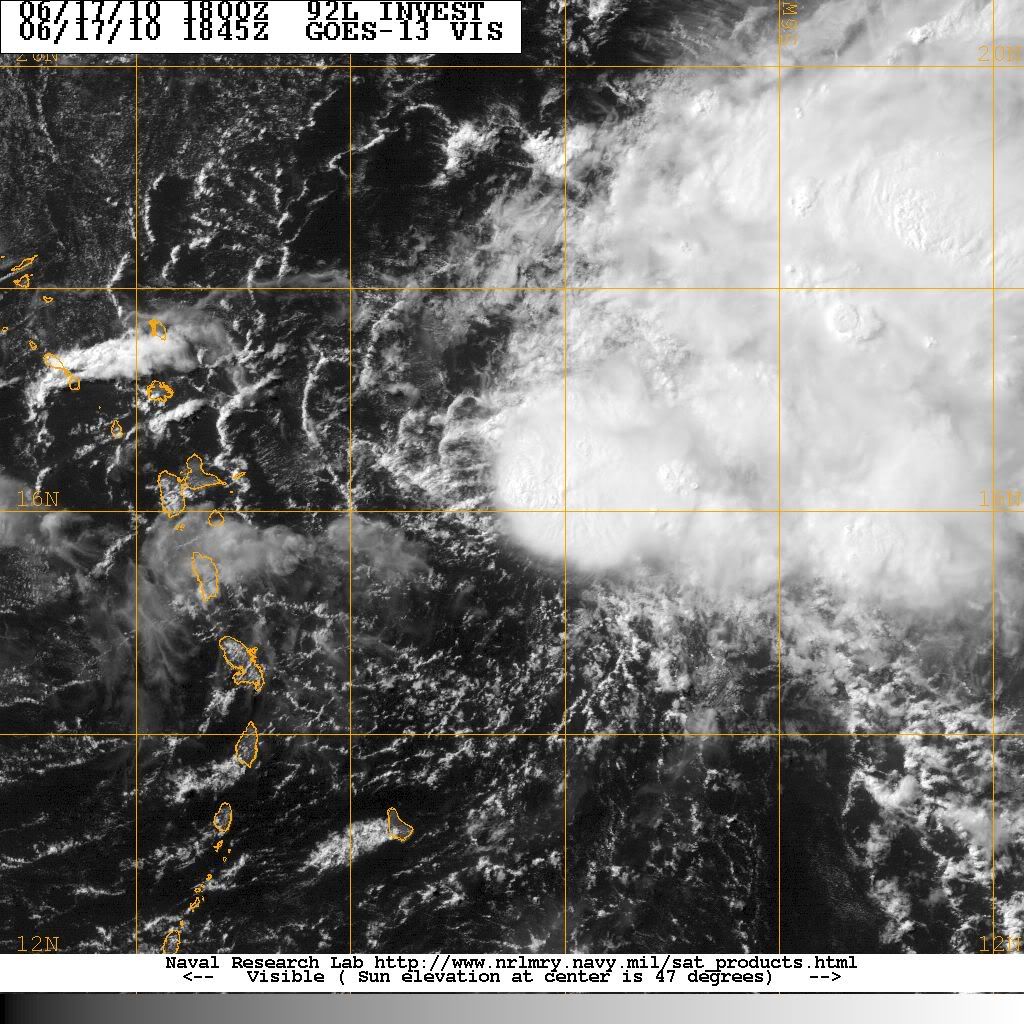
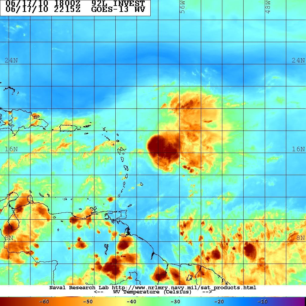
Still looks sheared. A fighter none the less...
Carla/Alicia/Jerry(In The Eye)/Michelle/Charley/Ivan/Dennis/Katrina/Rita/Wilma/Humberto/Ike/Harvey
Member: National Weather Association
Facebook.com/Weather Infinity
Twitter @WeatherInfinity
Member: National Weather Association
Facebook.com/Weather Infinity
Twitter @WeatherInfinity


Not too willing to write Invest 92L out yet.
I've been really curious about this one because I am leaving on a cruise this coming Monday. Anyone care to speculate on what impact we might see in BOC/Yucatan?
No rain, no rainbows.
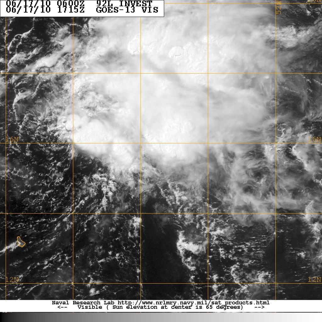
Invest 92L has fired up. The cloud tops are cold.
East of the Windward Island


East of the Windward Island
-
biggerbyte
- Posts: 1142
- Joined: Thu Feb 04, 2010 12:15 am
- Location: Porter, Texas. (Montgomery County)
- Contact:
92l will be reborn. Everybody had the right idea about this one all along.

It is just an area of extremely sheared convection within this tropical wave that is pushing steadily eastward. The only chance it has to possibly develop into a TD will not be until it nears the Bahamas and the FL Straights as the shear will likely finally subside... It is in an impossible area to develop right now as the westerly shear is screaming across the Leeward Islands
Anyway, the 0z GFS has whatever will be of 92L in the central GOM in about a week. I will definitely be watching this one closely as it moves out of this death zone it is stuck in at the moment...
I wouldn't put any stock in the exact forecasted position that far out at this point. Whatever will be left of 92L will likely move into the Eastern GOM, which is the main thing we should be paying attention to; Who knows where it goes once it enters the GOM. FWIW, the GFS is forecasting a large ridge to develop across the South next week. My initial knee-jerk reaction would be for 92L to just keep its course straight westward into Mexico, but that's just throwing darts at a pinhole right now...Ed Mahmoud wrote:GFS- headed straight for the oil spill...
The environment around Florida and the Eastern GOM should be much more favorable for perhaps a tropical cyclone developing in that region. For now, we won't see any development during the next couple of days.
I could have sworn 92 opened up after barfing outflows yesterday...now today it is looking better but highly sheared...
I retract my NEXT comment....for now...
I retract my NEXT comment....for now...
http://moe.met.fsu.edu/cgi-bin/hwrftc2. ... =Animation
thru the keys
0z GFDL up the EC
0z CMC into the WGOM
thru the keys
0z GFDL up the EC
0z CMC into the WGOM
-
srainhoutx
- Site Admin
- Posts: 19619
- Joined: Tue Feb 02, 2010 2:32 pm
- Location: Maggie Valley, NC
- Contact:
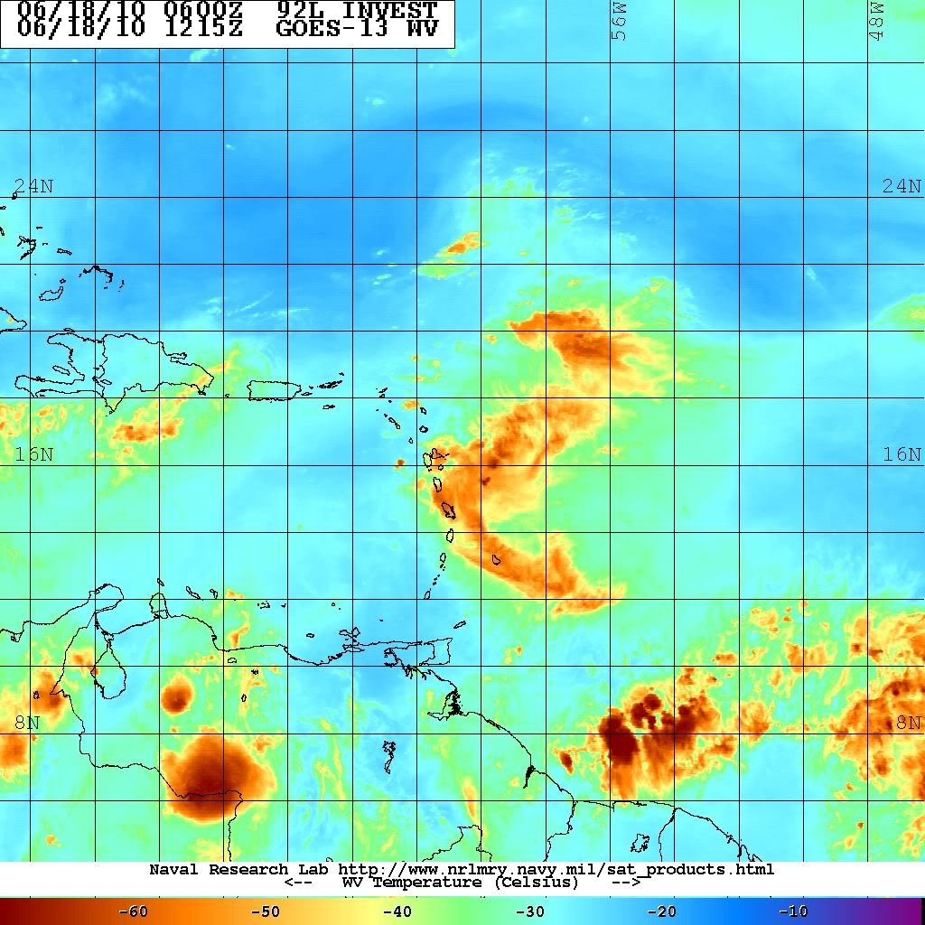
Looking mighty ragged this morning...
Carla/Alicia/Jerry(In The Eye)/Michelle/Charley/Ivan/Dennis/Katrina/Rita/Wilma/Humberto/Ike/Harvey
Member: National Weather Association
Facebook.com/Weather Infinity
Twitter @WeatherInfinity
Member: National Weather Association
Facebook.com/Weather Infinity
Twitter @WeatherInfinity
-
srainhoutx
- Site Admin
- Posts: 19619
- Joined: Tue Feb 02, 2010 2:32 pm
- Location: Maggie Valley, NC
- Contact:
Code: Select all
949
WHXX01 KWBC 181307
CHGHUR
TROPICAL CYCLONE GUIDANCE MESSAGE
NWS TPC/NATIONAL HURRICANE CENTER MIAMI FL
1307 UTC FRI JUN 18 2010

DISCLAIMER...NUMERICAL MODELS ARE SUBJECT TO LARGE ERRORS.
PLEASE REFER TO NHC OFFICIAL FORECASTS FOR TROPICAL CYCLONE
AND SUBTROPICAL CYCLONE INFORMATION.

ATLANTIC OBJECTIVE AIDS FOR

DISTURBANCE INVEST (AL922010) 20100618 1200 UTC

        ...00 HRS...   ...12 HRS...   ...24 HRS. ..   ...36 HRS...
        100618  1200   100619  0000   100619  1200   100620  0000

         LAT    LON     LAT    LON     LAT    LON     LAT    LON
BAMS    16.1N  62.2W   16.4N  65.4W   16.8N  68.9W   17.2N  71.7W
BAMD    16.1N  62.2W   16.5N  63.6W   16.8N  65.0W   17.1N  66.5W
BAMM    16.1N  62.2W   16.5N  64.5W   16.9N  66.9W   17.2N  69.1W
LBAR    16.1N  62.2W   16.4N  64.5W   16.8N  67.2W   17.2N  69.8W
SHIP        25KTS          24KTS          24KTS          26KTS
DSHP        25KTS          24KTS          24KTS          26KTS

        ...48 HRS...   ...72 HRS...   ...96 HRS. ..   ..120 HRS...
        100620  1200   100621  1200   100622  1200   100623  1200

         LAT    LON     LAT    LON     LAT    LON     LAT    LON
BAMS    17.2N  74.6W   17.9N  79.7W   18.2N  84.1W   18.0N  87.8W
BAMD    17.4N  68.1W   18.6N  71.0W   20.3N  74.0W   22.1N  76.7W
BAMM    17.5N  71.2W   18.3N  74.7W   19.4N  77.9W   20.6N  80.6W
LBAR    17.6N  72.6W   19.3N  77.0W   22.0N  80.5W   23.4N  83.0W
SHIP        28KTS          32KTS          42KTS          58KTS
DSHP        28KTS          31KTS          41KTS          58KTS

         ...INITIAL CONDITIONS...
LATCUR =  16.1N LONCUR =  62.2W DIRCUR = 270DEG SPDCUR =  12KT
LATM12 =  16.1N LONM12 =  59.3W DIRM12 = 273DEG SPDM12 =  11KT
LATM24 =  15.8N LONM24 =  57.2W
WNDCUR =   25KT RMAXWD =   60NM WNDM12 =   25KT
CENPRS = 1011MB OUTPRS = 1013MB OUTRAD =  120NM SDEPTH =   M
RD34NE =    0NM RD34SE =    0NM RD34SW =    0NM RD34NW =   0NM

$$
NNNN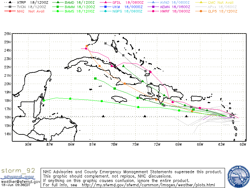
Carla/Alicia/Jerry(In The Eye)/Michelle/Charley/Ivan/Dennis/Katrina/Rita/Wilma/Humberto/Ike/Harvey
Member: National Weather Association
Facebook.com/Weather Infinity
Twitter @WeatherInfinity
Member: National Weather Association
Facebook.com/Weather Infinity
Twitter @WeatherInfinity