
June 2019: Showers/Storms Increasing To End June
-
srainhoutx

- Site Admin

- Posts: 19616
- Joined: Tue Feb 02, 2010 2:32 pm
- Location: Maggie Valley, NC
- Contact:
One more hot day with a chance of some severe weather across portions of N Central Texas and the Hill Country this afternoon/evening mainly along and S of the I-20 Corridor and then the first shot of cooler weather arrives tomorrow. It looks like highs in the 80's and lows in the low to mid 60's with NW breezes and clouds will be the theme this coming week.
- Attachments
-
Carla/Alicia/Jerry(In The Eye)/Michelle/Charley/Ivan/Dennis/Katrina/Rita/Wilma/Humberto/Ike/Harvey
Member: National Weather Association
Facebook.com/Weather Infinity
Twitter @WeatherInfinity
Member: National Weather Association
Facebook.com/Weather Infinity
Twitter @WeatherInfinity

90° by noon - typical summer day in the Brazos Valley. Heat indices to exceed 105°+ probable over CLL and areas SW.
Relief is on its way. Rain chances currently low with the frontal passage, although strong storms could make to Hearne and Caldwell. We'll see.
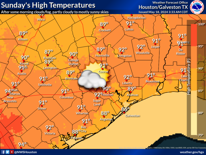
Relief is on its way. Rain chances currently low with the frontal passage, although strong storms could make to Hearne and Caldwell. We'll see.
- Attachments
-
Well all of a sudden models are turning pretty wet for Texas again.. that changed fast.

This has been alluded to in the long-range models, Specifically GFS brings fronts into the area next weekend and another back door front 8-9 days after that. We'll see - would be nice.
- Attachments
-
-
Canadian is also sniffing out the fronts, with less rain and not quite as far South.
Bring on as many fronts as possible. It's disgusting outside right now.
-
srainhoutx
- Site Admin
- Posts: 19616
- Joined: Tue Feb 02, 2010 2:32 pm
- Location: Maggie Valley, NC
- Contact:
62 kt wind gust reported at Love Field in Dallas. I also see reports of trucks blown over along 635
Carla/Alicia/Jerry(In The Eye)/Michelle/Charley/Ivan/Dennis/Katrina/Rita/Wilma/Humberto/Ike/Harvey
Member: National Weather Association
Facebook.com/Weather Infinity
Twitter @WeatherInfinity
Member: National Weather Association
Facebook.com/Weather Infinity
Twitter @WeatherInfinity
-
srainhoutx
- Site Admin
- Posts: 19616
- Joined: Tue Feb 02, 2010 2:32 pm
- Location: Maggie Valley, NC
- Contact:
Severe Thunderstorm Watch likely...
Mesoscale Discussion 1041
NWS Storm Prediction Center Norman OK
0207 PM CDT Sun Jun 09 2019
Areas affected...Much of central Texas
Concerning...Severe potential...Watch likely
Valid 091907Z - 092100Z
Probability of Watch Issuance...95 percent
SUMMARY...Severe thunderstorms will become increasing likely across
western North Texas southward into much of central Texas through
mid/late afternoon. A Severe Thunderstorm Watch will be issued
within the hour.
DISCUSSION...Visible satellite imagery trends in conjunction with
subjective surface analysis suggest that inhibition continues to
erode with increasingly common towering cumulus across the Big
Country, near and south of where south/southwestward-advancing
outflow is intercepting a northeast/southwest-oriented cold front.
The air mass along/east of the front is very unstable southward into
Edwards Plateau/Hill Country vicinity where lower 70s F surface
dewpoints are contributing to upwards of 4000 J/kg MLCAPE.
Thunderstorms are likely to continue to develop and increase in
coverage/intensity through the afternoon. Although
low/mid-tropospheric winds are not overly strong, factors such as
veering winds with height, somewhat stronger high-level westerlies,
as well as very strong buoyancy could allow for some initial intense
supercells. With time, storms should tend to organize into
southward-moving clusters with heightened wind damage potential into
a hot/very unstable environment across much of central Texas/Edwards
Plateau.
..Guyer/Thompson.. 06/09/2019
...Please see www.spc.noaa.gov for graphic product...
ATTN...WFO...HGX...FWD...EWX...SJT...
Carla/Alicia/Jerry(In The Eye)/Michelle/Charley/Ivan/Dennis/Katrina/Rita/Wilma/Humberto/Ike/Harvey
Member: National Weather Association
Facebook.com/Weather Infinity
Twitter @WeatherInfinity
Member: National Weather Association
Facebook.com/Weather Infinity
Twitter @WeatherInfinity
Brushing NW areas of the region:
Hazardous Weather Outlook...UPDATED
National Weather Service Fort Worth TX
1217 PM CDT Sun Jun 9 2019
TXZ091>095-100>107-115>123-129>135-141>148-156>162-174-175-101100-
Montague-Cooke-Grayson-Fannin-Lamar-Young-Jack-Wise-Denton-Collin-
Hunt-Delta-Hopkins-Stephens-Palo Pinto-Parker-Tarrant-Dallas-
Rockwall-Kaufman-Van Zandt-Rains-Eastland-Erath-Hood-Somervell-
Johnson-Ellis-Henderson-Comanche-Mills-Hamilton-Bosque-Hill-Navarro-
Freestone-Anderson-Lampasas-Coryell-Bell-McLennan-Falls-Limestone-
Leon-Milam-Robertson-
1217 PM CDT Sun Jun 9 2019
This Hazardous Weather Outlook is for North and Central Texas.
.DAY ONE...This Afternoon and Tonight.
Severe thunderstorms will be possible across much of North and
Central Texas this afternoon and evening. Through mid-afternoon, the
greatest threat will be in areas that are both east of I-35 and north
of I-30. For the mid to late afternoon time frame, the focus will be
primarily in areas west of the I-35 corridor along an advancing cold
front. The severe threat will spread east of I-35 into the evening
hours. Strong storms with a small hail threat may persist behind the
cold front overnight.
The main severe weather hazard will be damaging winds in excess of 60
mph. Destructive winds of 70 mph or more may accompany the strongest
storms. There will also be the potential for large hail, particularly
with the initial discrete cells. However, high storm bases and
unfavorable shear profiles should limit the tornadic potential.
In addition, heavy downpours may pose a flood risk through the event.
Heat index values of 105 to 110 degrees will be possible this
afternoon, particularly across western portions Central Texas. The
heat index may top 100 elsewhere before clouds and storms take the
edge off the heat.
.DAYS TWO THROUGH SEVEN...Monday through Saturday.
Low thunderstorm chances will linger Monday and Tuesday across
western portions of Central Texas, particularly during the morning
hours. These storms are not expected to be severe.
A few strong storms are possible late Tuesday night with a weakening
storm complex arriving into areas west of I-35 and north of I-20.
Similar complexes may impact the region late Thursday night into
Friday morning, then again Saturday night into Sunday morning. Severe
weather is not anticipated.
.SPOTTER INFORMATION STATEMENT...
Spotter activation is likely this afternoon and evening. Through
mid-afternoon, the main focus will be in areas that are north of the
I-20 corridor. For the mid to late afternoon time frame, activation
requests should be primarily in areas west of the I-35 corridor.
Evening requests will mainly be in areas along and east of I-35.
-
srainhoutx
- Site Admin
- Posts: 19616
- Joined: Tue Feb 02, 2010 2:32 pm
- Location: Maggie Valley, NC
- Contact:
Severe Thunderstorm Watch issued until 10 PM...
- Attachments
-
Carla/Alicia/Jerry(In The Eye)/Michelle/Charley/Ivan/Dennis/Katrina/Rita/Wilma/Humberto/Ike/Harvey
Member: National Weather Association
Facebook.com/Weather Infinity
Twitter @WeatherInfinity
Member: National Weather Association
Facebook.com/Weather Infinity
Twitter @WeatherInfinity


Cluster of cells tracking down I-45 to Centerville - Crocket area. Not sure they will hold together.
Message: NOAA-NWS-ALERTS-TX125CFE170BC0.SevereThunderstormWatch.125CFE237DB0TX.WNSWOU0.f5ff8000bb4aff5d523c2156450e06c3 from w-nws.webmaster@noaa.gov
Sent: 16:44 CDT on 06-09-2019
Effective: 16:50 CDT on 06-09-2019
Expires: 22:00 CDT on 06-09-2019
Event: Severe Thunderstorm Watch
Alert:
SEVERE THUNDERSTORM WATCH 350 IS IN EFFECT UNTIL 1000 PM CDT
FOR THE FOLLOWING LOCATIONS
TX
. TEXAS COUNTIES INCLUDED ARE
AUSTIN BRAZOS BURLESON
COLORADO DEWITT FAYETTE
GONZALES GRIMES KARNES
LAVACA MADISON MONTGOMERY
WALKER WALLER WASHINGTON
WILSON
Instructions:
Target Area:
Austin
Brazos
Burleson
Colorado
DeWitt
Fayette
Gonzales
Grimes
Karnes
Lavaca
Madison
Montgomery
Walker
Waller
Washington
Wilson
-
srainhoutx
- Site Admin
- Posts: 19616
- Joined: Tue Feb 02, 2010 2:32 pm
- Location: Maggie Valley, NC
- Contact:
Severe Thunderstorm Watch issued until 10 PM
- Attachments
-
Carla/Alicia/Jerry(In The Eye)/Michelle/Charley/Ivan/Dennis/Katrina/Rita/Wilma/Humberto/Ike/Harvey
Member: National Weather Association
Facebook.com/Weather Infinity
Twitter @WeatherInfinity
Member: National Weather Association
Facebook.com/Weather Infinity
Twitter @WeatherInfinity
incoming:
Message: NOAA-NWS-ALERTS-TX125CFE1725EC.SpecialWeatherStatement.125CFE174E8CTX.HGXSPSHGX.70cd504c1f098feea484fc838381f216 from w-nws.webmaster@noaa.gov
Sent: 17:11 CDT on 06-09-2019
Effective: 16:24 CDT on 06-09-2019
Expires: 18:15 CDT on 06-09-2019
Event: Special Weather Statement
Alert:
...SIGNIFICANT WEATHER ADVISORY FOR CENTRAL BURLESON AND BRAZOS
COUNTIES UNTIL 615 PM CDT...
At 511 PM CDT, Doppler radar was tracking a strong thunderstorm near
Franklin, or 10 miles northeast of Hearne, moving south at 40 mph.
Nickel size hail and winds in excess of 40 mph will be possible with
this storm.
Locations impacted include...
College Station, Bryan, Caldwell, Snook, Kurten, Wixon Valley,
Millican, Kyle Field and Wellborn.
A Severe Thunderstorm Watch remains in effect until 1000 PM CDT for
southeastern Texas.
Instructions: Frequent cloud to ground lightning is occurring with this storm. Lightning can strike 10 miles away from a thunderstorm. Seek a safe shelter inside a building or vehicle.
Target Area:
Brazos
Burleson

Both clusters are holding together, at least until close to sunset.
Cells are starting to tank, now... At least we'll see an outflow breeze.
Wow, unexpected pop up thunderstorm in Rosharon.