
June 2019: Showers/Storms Increasing To End June
Barely missed me to the south in Rosharon. Nice blue green hail storm that skirted by us. Ugly wall cloud too.
Another 1 1/2” of rain today. 8” yesterday morning, 1/2” this morning from a severe warned storm, and another 1” this evening from a severe storm. I hit the jackpot this go round.
-
srainhoutx

- Site Admin

- Posts: 19616
- Joined: Tue Feb 02, 2010 2:32 pm
- Location: Maggie Valley, NC
- Contact:
Some drier air has filtered in and a weak front is situated across NE Texas this morning. Additional drier air may filter down tonight into tomorrow resulting in slightly cooler temperatures than were earlier expected today and tomorrow (low 90's versus mid 90's).
Sunday night the first in a series of 'cold fronts' arrive bringing much lower dew points (upper 50's versus low to mid 70's) likely by mid to late next week. I do think that isolated to scattered showers and perhaps a thundershower or two may be possible most of next week. While it is not unheard of to see mid June fronts this far South, it has been a while.
Sunday night the first in a series of 'cold fronts' arrive bringing much lower dew points (upper 50's versus low to mid 70's) likely by mid to late next week. I do think that isolated to scattered showers and perhaps a thundershower or two may be possible most of next week. While it is not unheard of to see mid June fronts this far South, it has been a while.
- Attachments
-
-
Carla/Alicia/Jerry(In The Eye)/Michelle/Charley/Ivan/Dennis/Katrina/Rita/Wilma/Humberto/Ike/Harvey
Member: National Weather Association
Facebook.com/Weather Infinity
Twitter @WeatherInfinity
Member: National Weather Association
Facebook.com/Weather Infinity
Twitter @WeatherInfinity
-
tireman4

- Global Moderator

- Posts: 4488
- Joined: Wed Feb 03, 2010 9:24 pm
- Location: Humble, Texas
- Contact:
Alluding to Srain's spot on forecast, as usual, the HGX folks feel the same way in the short and long term....
000
FXUS64 KHGX 071610
AFDHGX
Area Forecast Discussion
National Weather Service Houston/Galveston TX
1110 AM CDT Fri Jun 7 2019
.SHORT TERM [Today through Evening]...
Scattered clouds across the area remain after the stratus deck
scattered out. Southwest converging into northwesterly flow
blankets the area. Northwesterly flow bringing in lower dewpoints
lower to upper 60s and southwesterly flow still ushering in mid
to upper 70 dewpoints. Expect that as the flow weakens late this
afternoon the seabreeze will stall just in from the coast a few
miles or possibly creep very slowly inland through 6 pm. Will be
paring back POPs over the western and central areas and
maintaining chance pops along the coast and lower in the far
northeastern counties closer to the low.
Temperatures minor adjustments to bump up temperatures a degree or
two near the coast early this afternoon then any storms that
develop should arrest the rise thanks to an increase in cloud
cover. If the storms don`t pan out may need to nudge them up a bit
more in the short term.
45
&&
.PREV DISCUSSION /Issued 656 AM CDT Fri Jun 7 2019/...
.LONG TERM...
Weak high pressure will settle over SE TX Saturday night in the
wake of a very weak cold front. Generally clear skies are expected
Saturday night but despite the fropa, MinT will remain on the warm
side. The warm start to Sunday coupled with 850 mb temperatures
around 24 C will yield high temperatures in the upper 90`s. Sunday
will likely be the warmest day of the year so far. There is some
dry air in the soundings which should mix to the surface so dew
points are expected to fall to near 70 by afternoon. There could
be some heat index issues along the coast once the sea breeze
moves inland in the late afternoon. Between 3-7 PM, some heat
index values in the coastal counties will be between 107 and 110
degrees so a Heat Advisory may be required.
A cold front will approach the region on Sunday night. Clouds
will be on the increase late and even a few showers will be
possible over the NW part of the region prior to sunrise on Monday.
The front will cross the rest of the CWA early Monday morning.
Some showers and isolated thunderstorms will be possible Monday as
a weak short wave rotates around an expanding upper ridge over N
Mexico and SW TX. The upper ridge dampens a bit Monday night into
Tuesday as another short wave over the central Rockies moves E-SE
and phases with another short wave over the Central Plains to
carve out a long wave trough that moves across East Texas. This
feature will enhance lift and bring the region scattered showers.
Wednesday and Thursday look dry for now as surface winds remain
N-NE and PW values lower to around 1.20 inches. Seasonal
temperatures are expected during the day but the humidity will be
low so it should feel reasonably comfortable. Since the air mass
is dry, overnight lows should cool off into the 60`s over the
north and around 70 south. The flow aloft is NW and we`ll need to
watch and see if anything develops in the lee of the Rockies that
could head this way. The GFS hints at such a scenario on Friday.
Onshore winds will return on Friday as will the humidity and
slightly warmer temperatures. 43
.AVIATION [12Z TAF Issuance]...
VFR conditions expected to prevail across all SE TX terminals
today. A weak frontal boundary will continue to sag southward
and stall out along the coast. Short term guidance has struggled
to initialize well this morning, but overall NMM, ARW, and HRRR
all show some development of precip this afternoon along an axis
of convergence that looks to set up over the coastal counties,
potentially impacting LBX and GLS. If we do get such development,
and with convective temperatures in reach, we should get
thunderstorms along this boundary. Convection would wane with the
loss of daytime heating and VFR conditions will prevail through
the overnight hours. Winds will be turning more out of the
northwest by the afternoon hours behind this boundary, and
increase in speed to between 8-14 knots area wide. Any residual
surface moisture associated with today`s precip could result in
radiational fog overnight tonight with mostly clear skies and
light winds anticipated.
Hathaway
.MARINE...
Moderate SW winds will turn more out of the west this afternoon,
as a weak frontal boundary approaches the region but stalls north
of the coastal waters. Showers and thunderstorms will be possible
mostly over the eastern Gulf waters today, due to a combination of
both this axis of convergence and the sea breeze. Winds will turn
more out of the northwest by tomorrow afternoon, before onshore
flow returns Sunday afternoon. A weak frontal boundary moves
through the Gulf waters Monday, and winds will turn out of the
north to northeast behind this frontal passage. Still not
anticipating any need for flags at this time. Additionally, tides
are running near normal, which should continue into early next
week.
Hathaway
&&
.PRELIMINARY POINT TEMPS/POPS...
College Station (CLL) 90 71 94 74 97 / 10 0 0 0 0
Houston (IAH) 94 73 95 75 97 / 10 0 0 0 0
Galveston (GLS) 91 79 92 81 91 / 40 10 0 0 0
&&
.HGX WATCHES/WARNINGS/ADVISORIES...
TX...None.
GM...None.
&&
$$
SHORT TERM...45

Felt pretty good last night and this morning. NNW breezes, DPs in the 60s. Temps in the 80s. Everything is green, crisp sunshine. The longer we can delay the Death Ridge and Texas summer the better.
Gonna be a steamy mosquito infested mess this weekend.
-
srainhoutx
- Site Admin
- Posts: 19616
- Joined: Tue Feb 02, 2010 2:32 pm
- Location: Maggie Valley, NC
- Contact:
Looking ahead toward the end of June/beginning of July, the afternoon Updated Week 3 to Week 4 Experimental Outlook suggests below normal temperatures and above normal precipitation.
- Attachments
-
-
Carla/Alicia/Jerry(In The Eye)/Michelle/Charley/Ivan/Dennis/Katrina/Rita/Wilma/Humberto/Ike/Harvey
Member: National Weather Association
Facebook.com/Weather Infinity
Twitter @WeatherInfinity
Member: National Weather Association
Facebook.com/Weather Infinity
Twitter @WeatherInfinity
Wow srain I hope that forecast holds.srainhoutx wrote: ↑Fri Jun 07, 2019 2:32 pm Looking ahead toward the end of June/beginning of July, the afternoon Updated Week 3 to Week 4 Experimental Outlook suggests below normal temperatures and above normal precipitation.

I do too! Today is just too darn hot! And it's only June.cperk wrote: ↑Fri Jun 07, 2019 3:47 pmWow srain I hope that forecast holds.srainhoutx wrote: ↑Fri Jun 07, 2019 2:32 pm Looking ahead toward the end of June/beginning of July, the afternoon Updated Week 3 to Week 4 Experimental Outlook suggests below normal temperatures and above normal precipitation.
The latest Euro looks a little interesting for areas south of 10 Tuesday and Wednesday. It has an area of about 1-3” of rain.
-
srainhoutx
- Site Admin
- Posts: 19616
- Joined: Tue Feb 02, 2010 2:32 pm
- Location: Maggie Valley, NC
- Contact:
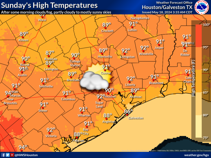
One more hot day with a chance of some severe weather across portions of N Central Texas and the Hill Country this afternoon/evening mainly along and S of the I-20 Corridor and then the first shot of cooler weather arrives tomorrow. It looks like highs in the 80's and lows in the low to mid 60's with NW breezes and clouds will be the theme this coming week.
- Attachments
-
Carla/Alicia/Jerry(In The Eye)/Michelle/Charley/Ivan/Dennis/Katrina/Rita/Wilma/Humberto/Ike/Harvey
Member: National Weather Association
Facebook.com/Weather Infinity
Twitter @WeatherInfinity
Member: National Weather Association
Facebook.com/Weather Infinity
Twitter @WeatherInfinity
90° by noon - typical summer day in the Brazos Valley. Heat indices to exceed 105°+ probable over CLL and areas SW.
Relief is on its way. Rain chances currently low with the frontal passage, although strong storms could make to Hearne and Caldwell. We'll see.
Relief is on its way. Rain chances currently low with the frontal passage, although strong storms could make to Hearne and Caldwell. We'll see.
- Attachments
-
Well all of a sudden models are turning pretty wet for Texas again.. that changed fast.

This has been alluded to in the long-range models, Specifically GFS brings fronts into the area next weekend and another back door front 8-9 days after that. We'll see - would be nice.
- Attachments
-
-
Canadian is also sniffing out the fronts, with less rain and not quite as far South.
Bring on as many fronts as possible. It's disgusting outside right now.
-
srainhoutx
- Site Admin
- Posts: 19616
- Joined: Tue Feb 02, 2010 2:32 pm
- Location: Maggie Valley, NC
- Contact:
62 kt wind gust reported at Love Field in Dallas. I also see reports of trucks blown over along 635
Carla/Alicia/Jerry(In The Eye)/Michelle/Charley/Ivan/Dennis/Katrina/Rita/Wilma/Humberto/Ike/Harvey
Member: National Weather Association
Facebook.com/Weather Infinity
Twitter @WeatherInfinity
Member: National Weather Association
Facebook.com/Weather Infinity
Twitter @WeatherInfinity
-
srainhoutx
- Site Admin
- Posts: 19616
- Joined: Tue Feb 02, 2010 2:32 pm
- Location: Maggie Valley, NC
- Contact:
Severe Thunderstorm Watch likely...
Mesoscale Discussion 1041
NWS Storm Prediction Center Norman OK
0207 PM CDT Sun Jun 09 2019
Areas affected...Much of central Texas
Concerning...Severe potential...Watch likely
Valid 091907Z - 092100Z
Probability of Watch Issuance...95 percent
SUMMARY...Severe thunderstorms will become increasing likely across
western North Texas southward into much of central Texas through
mid/late afternoon. A Severe Thunderstorm Watch will be issued
within the hour.
DISCUSSION...Visible satellite imagery trends in conjunction with
subjective surface analysis suggest that inhibition continues to
erode with increasingly common towering cumulus across the Big
Country, near and south of where south/southwestward-advancing
outflow is intercepting a northeast/southwest-oriented cold front.
The air mass along/east of the front is very unstable southward into
Edwards Plateau/Hill Country vicinity where lower 70s F surface
dewpoints are contributing to upwards of 4000 J/kg MLCAPE.
Thunderstorms are likely to continue to develop and increase in
coverage/intensity through the afternoon. Although
low/mid-tropospheric winds are not overly strong, factors such as
veering winds with height, somewhat stronger high-level westerlies,
as well as very strong buoyancy could allow for some initial intense
supercells. With time, storms should tend to organize into
southward-moving clusters with heightened wind damage potential into
a hot/very unstable environment across much of central Texas/Edwards
Plateau.
..Guyer/Thompson.. 06/09/2019
...Please see www.spc.noaa.gov for graphic product...
ATTN...WFO...HGX...FWD...EWX...SJT...
Carla/Alicia/Jerry(In The Eye)/Michelle/Charley/Ivan/Dennis/Katrina/Rita/Wilma/Humberto/Ike/Harvey
Member: National Weather Association
Facebook.com/Weather Infinity
Twitter @WeatherInfinity
Member: National Weather Association
Facebook.com/Weather Infinity
Twitter @WeatherInfinity
Brushing NW areas of the region:
Hazardous Weather Outlook...UPDATED
National Weather Service Fort Worth TX
1217 PM CDT Sun Jun 9 2019
TXZ091>095-100>107-115>123-129>135-141>148-156>162-174-175-101100-
Montague-Cooke-Grayson-Fannin-Lamar-Young-Jack-Wise-Denton-Collin-
Hunt-Delta-Hopkins-Stephens-Palo Pinto-Parker-Tarrant-Dallas-
Rockwall-Kaufman-Van Zandt-Rains-Eastland-Erath-Hood-Somervell-
Johnson-Ellis-Henderson-Comanche-Mills-Hamilton-Bosque-Hill-Navarro-
Freestone-Anderson-Lampasas-Coryell-Bell-McLennan-Falls-Limestone-
Leon-Milam-Robertson-
1217 PM CDT Sun Jun 9 2019
This Hazardous Weather Outlook is for North and Central Texas.
.DAY ONE...This Afternoon and Tonight.
Severe thunderstorms will be possible across much of North and
Central Texas this afternoon and evening. Through mid-afternoon, the
greatest threat will be in areas that are both east of I-35 and north
of I-30. For the mid to late afternoon time frame, the focus will be
primarily in areas west of the I-35 corridor along an advancing cold
front. The severe threat will spread east of I-35 into the evening
hours. Strong storms with a small hail threat may persist behind the
cold front overnight.
The main severe weather hazard will be damaging winds in excess of 60
mph. Destructive winds of 70 mph or more may accompany the strongest
storms. There will also be the potential for large hail, particularly
with the initial discrete cells. However, high storm bases and
unfavorable shear profiles should limit the tornadic potential.
In addition, heavy downpours may pose a flood risk through the event.
Heat index values of 105 to 110 degrees will be possible this
afternoon, particularly across western portions Central Texas. The
heat index may top 100 elsewhere before clouds and storms take the
edge off the heat.
.DAYS TWO THROUGH SEVEN...Monday through Saturday.
Low thunderstorm chances will linger Monday and Tuesday across
western portions of Central Texas, particularly during the morning
hours. These storms are not expected to be severe.
A few strong storms are possible late Tuesday night with a weakening
storm complex arriving into areas west of I-35 and north of I-20.
Similar complexes may impact the region late Thursday night into
Friday morning, then again Saturday night into Sunday morning. Severe
weather is not anticipated.
.SPOTTER INFORMATION STATEMENT...
Spotter activation is likely this afternoon and evening. Through
mid-afternoon, the main focus will be in areas that are north of the
I-20 corridor. For the mid to late afternoon time frame, activation
requests should be primarily in areas west of the I-35 corridor.
Evening requests will mainly be in areas along and east of I-35.
-
srainhoutx
- Site Admin
- Posts: 19616
- Joined: Tue Feb 02, 2010 2:32 pm
- Location: Maggie Valley, NC
- Contact:
Severe Thunderstorm Watch issued until 10 PM...
- Attachments
-
Carla/Alicia/Jerry(In The Eye)/Michelle/Charley/Ivan/Dennis/Katrina/Rita/Wilma/Humberto/Ike/Harvey
Member: National Weather Association
Facebook.com/Weather Infinity
Twitter @WeatherInfinity
Member: National Weather Association
Facebook.com/Weather Infinity
Twitter @WeatherInfinity
-
- Information
-
Who is online
Users browsing this forum: Ahrefs [Bot], Amazon [Bot], Bing [Bot] and 64 guests