

MAY 2019: Wednesday Storm Complex/Scattered Showers To End May
I would watch out if you live about 20 miles on either side of the 59 corridor specifically from around Houston towards maybe as far as Victoria or even Beeville. Some models are keying in on that area for training later this afternoon into the evening hours.
Last edited by Cpv17 on Thu May 09, 2019 8:42 am, edited 2 times in total.
-
srainhoutx

- Site Admin

- Posts: 19616
- Joined: Tue Feb 02, 2010 2:32 pm
- Location: Maggie Valley, NC
- Contact:
Thursday morning Weather Briefing from Jeff:
Heavy rainfall and flash flood/flood event increasing likely.
Flash flood watch will be in effect for the entire region from 100pm today until 700pm Friday
Rainfall Amounts: 5-8 inches widespread (9-12 inches isolated)
Hourly Rainfall: 2-4 inches possible
Timing: Late this afternoon/evening into Saturday
Watersheds: creek, bayou, river flooding possible. Some structures/homes may be threatened (3-4 inches in 3 hrs will likely cause flooding on some watersheds in the county)
Street: significant street flooding possible in areas of high hourly rainfall rates
Addicks Reservoir:
With 8.5 inches of rainfall over the next 5 days the pool is forecasted by the COE to rise to 1.5 feet below the level that would impact HWY 6
Barker Reservoir:
With 8.5 inches of rainfall over the next 5 days the pool is forecasted by the COE to rise to 1-2 feet below the level that would impact Westheimer Pkwy
HCFCD Actions:
· Opened the Clear Creek Outlet Gates yesterday to help expedite the flow of storm water run-off out of Clear Creek
· Staffing plan is in place to staff both the EOC and HCFCD today-Saturday
· Coordination continues with NWS, WGRFC, SJRA, and other local partners on forecasts and potential impacts.
· Teams are ready to collect discharge measurements. One crew has been helping Fort Bend County over the last 24 hours collecting data along the Brazos River
· Gage 100 is having transmission issues and HCFCD staff will be onsite this morning to troubleshoot
Synopsis:
Stalled outflow boundary from yesterday’s complex of thunderstorms over the northern counties is roughly along a line from Columbus to Livingston this morning. A weak cold front is moving through central Texas and will enter SE TX this afternoon. As the air mass heats it will become increasingly unstable today with showers and thunderstorms likely forming along both the incoming frontal boundary and any leftover outflow boundaries. Most of the models hold off on any significant development until after 4-6pm, but a few do show storms developing early this afternoon. Thunderstorms are likely tonight both locally and from any complexes that may approach from SC/C TX into early Friday morning. Air mass is certainly capable of some impressive rainfall rates and totals with PWS rising to near 2.0 inches and good low level inflow projected off the Gulf of Mexico. With increasing diffluence aloft, and approach of disturbances out of Mexico many factors are in place for heavy rainfall tonight into Friday. The capability of this air mass to produce intense short term rainfall totals of 2-6 inches in 1-2 hours is very much a possibility.
Where exactly intense rainfall develops remains the question and trends will have to be monitored closely today. Given saturated grounds, much of the rainfall will be converted to run-off with rapid rises on area creeks, bayous, and rivers. Flash flood guidance is low and coordination with the WGRFC yesterday suggests that 3-4 inches of rainfall in a 3 hour period would likely result in overbank flooding on some Harris County watersheds.
Excessive Rainfall Outlook (Today):
5-day Rainfall Totals:
Heavy rainfall and flash flood/flood event increasing likely.
Flash flood watch will be in effect for the entire region from 100pm today until 700pm Friday
Rainfall Amounts: 5-8 inches widespread (9-12 inches isolated)
Hourly Rainfall: 2-4 inches possible
Timing: Late this afternoon/evening into Saturday
Watersheds: creek, bayou, river flooding possible. Some structures/homes may be threatened (3-4 inches in 3 hrs will likely cause flooding on some watersheds in the county)
Street: significant street flooding possible in areas of high hourly rainfall rates
Addicks Reservoir:
With 8.5 inches of rainfall over the next 5 days the pool is forecasted by the COE to rise to 1.5 feet below the level that would impact HWY 6
Barker Reservoir:
With 8.5 inches of rainfall over the next 5 days the pool is forecasted by the COE to rise to 1-2 feet below the level that would impact Westheimer Pkwy
HCFCD Actions:
· Opened the Clear Creek Outlet Gates yesterday to help expedite the flow of storm water run-off out of Clear Creek
· Staffing plan is in place to staff both the EOC and HCFCD today-Saturday
· Coordination continues with NWS, WGRFC, SJRA, and other local partners on forecasts and potential impacts.
· Teams are ready to collect discharge measurements. One crew has been helping Fort Bend County over the last 24 hours collecting data along the Brazos River
· Gage 100 is having transmission issues and HCFCD staff will be onsite this morning to troubleshoot
Synopsis:
Stalled outflow boundary from yesterday’s complex of thunderstorms over the northern counties is roughly along a line from Columbus to Livingston this morning. A weak cold front is moving through central Texas and will enter SE TX this afternoon. As the air mass heats it will become increasingly unstable today with showers and thunderstorms likely forming along both the incoming frontal boundary and any leftover outflow boundaries. Most of the models hold off on any significant development until after 4-6pm, but a few do show storms developing early this afternoon. Thunderstorms are likely tonight both locally and from any complexes that may approach from SC/C TX into early Friday morning. Air mass is certainly capable of some impressive rainfall rates and totals with PWS rising to near 2.0 inches and good low level inflow projected off the Gulf of Mexico. With increasing diffluence aloft, and approach of disturbances out of Mexico many factors are in place for heavy rainfall tonight into Friday. The capability of this air mass to produce intense short term rainfall totals of 2-6 inches in 1-2 hours is very much a possibility.
Where exactly intense rainfall develops remains the question and trends will have to be monitored closely today. Given saturated grounds, much of the rainfall will be converted to run-off with rapid rises on area creeks, bayous, and rivers. Flash flood guidance is low and coordination with the WGRFC yesterday suggests that 3-4 inches of rainfall in a 3 hour period would likely result in overbank flooding on some Harris County watersheds.
Excessive Rainfall Outlook (Today):
Carla/Alicia/Jerry(In The Eye)/Michelle/Charley/Ivan/Dennis/Katrina/Rita/Wilma/Humberto/Ike/Harvey
Member: National Weather Association
Facebook.com/Weather Infinity
Twitter @WeatherInfinity
Member: National Weather Association
Facebook.com/Weather Infinity
Twitter @WeatherInfinity
-
srainhoutx
- Site Admin
- Posts: 19616
- Joined: Tue Feb 02, 2010 2:32 pm
- Location: Maggie Valley, NC
- Contact:
While it's just one of the short fuse mesoscale models, that 12Z HRRR does suggest the Mesoscale Convective Vortex (MCV) or wound up area of low pressure riding up along the boundary. We'll see how well that models does as the day and evening progresses.
- Attachments
-
Carla/Alicia/Jerry(In The Eye)/Michelle/Charley/Ivan/Dennis/Katrina/Rita/Wilma/Humberto/Ike/Harvey
Member: National Weather Association
Facebook.com/Weather Infinity
Twitter @WeatherInfinity
Member: National Weather Association
Facebook.com/Weather Infinity
Twitter @WeatherInfinity
-
Txrunner82
- Posts: 4
- Joined: Sat Dec 01, 2018 1:32 pm
- Contact:
What’s the probability for training to happen?
-
Texaspirate11

- Posts: 1278
- Joined: Tue Dec 31, 2013 12:24 am
- Contact:
Be Safe everyone -
Just because you're disabled, you don't have to be a victim
Be Weather Aware & Prepared!
Barbara Jordan Winner in Media
Disability Integration Consultant
Be Weather Aware & Prepared!
Barbara Jordan Winner in Media
Disability Integration Consultant
-
srainhoutx
- Site Admin
- Posts: 19616
- Joined: Tue Feb 02, 2010 2:32 pm
- Location: Maggie Valley, NC
- Contact:
Not sure we can put an percentage on the chance of training. It is a possibility that is not negligible
Carla/Alicia/Jerry(In The Eye)/Michelle/Charley/Ivan/Dennis/Katrina/Rita/Wilma/Humberto/Ike/Harvey
Member: National Weather Association
Facebook.com/Weather Infinity
Twitter @WeatherInfinity
Member: National Weather Association
Facebook.com/Weather Infinity
Twitter @WeatherInfinity
I’m curious to know where the boundary is located because that’s the area that stands the best shot at seeing any training. HRRR wants to set it up right on top of me. This image is a really good image at showing where the boundary sets up.

The HRRR model is usually one of the better short range mesoscale models. It’s one I often look at, but even that model isn’t perfect. No model even sniffed out what was in store for us on Tuesday.
Rain totals along the boundary are pretty impressive through 18 hours:

Cool link to show all the factors in play. Cold front moving south, Pacific moisture streaming in from the southwest, and moisture being drawn in from the gulf. As you can see at the border of Mexico convection is really starting to pop.
https://www.tropicaltidbits.com/sat/sat ... roduct=vis
https://www.tropicaltidbits.com/sat/sat ... roduct=vis
-
stormlover
- Posts: 439
- Joined: Wed Dec 04, 2013 10:21 am
- Location: Lumberton TX
- Contact:
Cp ur right that’s only 18 hours, that’s a good amount, I think gfs and euro have struggled all week with this and hrr is usually pretty good when the event is about to happen
narrow line popping from Cameron to Nacogdoches and moving south.
Let’s connect the two dots here. Storms are firing off to the north of Laredo and the line of storms from last night looks to have stalled out near Lake Charles, LA. Now connect the two points +/- 20 or so miles and that may be where the boundary is located. You may also be able to see it on satellite.
Last edited by Cpv17 on Thu May 09, 2019 10:15 am, edited 1 time in total.


-
redneckweather
- Posts: 1023
- Joined: Mon Feb 08, 2010 7:29 pm
- Location: Montgomery, Texas
- Contact:
Extremely thick cloud deck over Southeast, Texas currently which will keep things semi stabilized as ingredients try to come together. Now if the sun would poke out a bit it would really stir things up. I would look for a wide spread 1-2 inches or rain with some isolated 3 to 4 inches totals across the area. At least I hope. I would like to mow my back pasture sometime in the next few weeks. 
After looking at the models, I was thinking that the SPC should extend it’s slight risk further SW. I was just about to come on here and say that, but before I did I went and checked out their website and sure enough they did just that lol
They do mention that supercells are a possibility. Main risks will be hail and high winds.
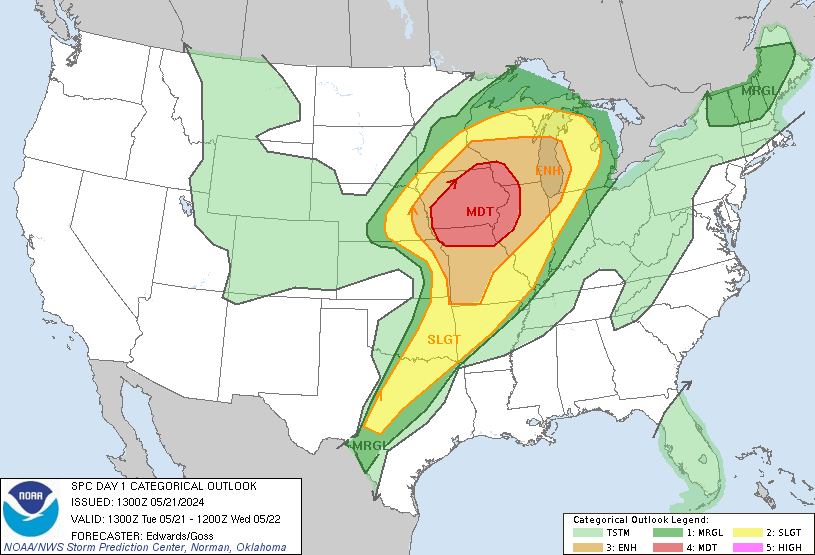
They do mention that supercells are a possibility. Main risks will be hail and high winds.
-
srainhoutx
- Site Admin
- Posts: 19616
- Joined: Tue Feb 02, 2010 2:32 pm
- Location: Maggie Valley, NC
- Contact:
Clouds have thinned out a bit and we are beginning to see the sun peak through across NW Harris County
- Attachments
-
Carla/Alicia/Jerry(In The Eye)/Michelle/Charley/Ivan/Dennis/Katrina/Rita/Wilma/Humberto/Ike/Harvey
Member: National Weather Association
Facebook.com/Weather Infinity
Twitter @WeatherInfinity
Member: National Weather Association
Facebook.com/Weather Infinity
Twitter @WeatherInfinity
- Attachments
-
Last edited by spadilly on Thu May 09, 2019 11:13 am, edited 1 time in total.
-
stormlover
- Posts: 439
- Joined: Wed Dec 04, 2013 10:21 am
- Location: Lumberton TX
- Contact:
If gfs run is right but prob won’t be but who knows drops hammer on golden triangle
GFS is similar to the HRRR.stormlover wrote: ↑Thu May 09, 2019 11:07 am If gfs run is right but prob won’t be but who knows drops hammer on golden triangle
-
stormlover
- Posts: 439
- Joined: Wed Dec 04, 2013 10:21 am
- Location: Lumberton TX
- Contact:
Maybe we are getting some model consistency

Can you post the gfs graphic?
Mike
Beaumont, TX
(IH-10 & College Street)
Beaumont, TX
(IH-10 & College Street)