
MAY 2019: Wednesday Storm Complex/Scattered Showers To End May
The storm south of Columbus appears to be strengthening again. One nasty looking cell.

Message: NOAA-NWS-ALERTS-TX125CF7C4F160.TornadoWarning.125CF7C4F5ACTX.HGXSVSHGX.dc15a3f0557ecc998d46d3cc56c7ae7c from w-nws.webmaster@noaa.gov
Sent: 12:04 CDT on 05-03-2019
Effective: 12:04 CDT on 05-03-2019
Expires: 12:15 CDT on 05-03-2019
Event: Tornado Warning
Alert:
...A TORNADO WARNING REMAINS IN EFFECT UNTIL 1215 PM CDT FOR CENTRAL
WALLER AND NORTHWESTERN HARRIS COUNTIES...
At 1204 PM CDT, a severe thunderstorm capable of producing a tornado
was located over Pine Island, or near Hempstead, moving northeast at
15 mph.
HAZARD...Tornado.
SOURCE...Radar indicated rotation.
IMPACT...Flying debris will be dangerous to those caught without
shelter. Mobile homes will be damaged or destroyed. Damage
to roofs, windows, and vehicles will occur. Tree damage is
likely.
Locations impacted include...
Hempstead, Prairie View and Pine Island.
TORNADO...RADAR INDICATED
HAIL...<.75IN
Instructions: TAKE COVER NOW! Move to a basement or an interior room on the lowest floor of a sturdy building. Avoid windows. If you are outdoors, in a mobile home, or in a vehicle, move to the closest substantial shelter and protect yourself from flying debris.
Target Area:
Harris
Waller
Message: NOAA-NWS-ALERTS-TX125CF7C4DE3C.SevereThunderstormWarning.125CF7C4FB88TX.HGXSVRHGX.ec592817562f8f0cb0275733882ceed8 from w-nws.webmaster@noaa.gov
Sent: 11:55 CDT on 05-03-2019
Effective: 11:55 CDT on 05-03-2019
Expires: 12:30 CDT on 05-03-2019
Event: Severe Thunderstorm Warning
Alert:
The National Weather Service in League City has issued a
* Severe Thunderstorm Warning for...
Central Colorado County in southeastern Texas...
* Until 1230 PM CDT.
* At 1155 AM CDT, a severe thunderstorm was located near Columbus,
moving east at 10 mph.
HAZARD...Quarter size hail.
SOURCE...Radar indicated.
IMPACT...Damage to vehicles is expected.
* Locations impacted include...
Columbus, Altair and Rock Island.
HAIL...1.00IN
WIND...<50MPH
Instructions: For your protection move to an interior room on the lowest floor of a building.
Target Area:
Colorado
-
srainhoutx

- Site Admin

- Posts: 19616
- Joined: Tue Feb 02, 2010 2:32 pm
- Location: Maggie Valley, NC
- Contact:
Spotter reports Tornado near Columbus
Carla/Alicia/Jerry(In The Eye)/Michelle/Charley/Ivan/Dennis/Katrina/Rita/Wilma/Humberto/Ike/Harvey
Member: National Weather Association
Facebook.com/Weather Infinity
Twitter @WeatherInfinity
Member: National Weather Association
Facebook.com/Weather Infinity
Twitter @WeatherInfinity
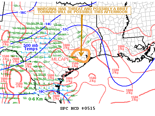
Mesoscale Discussion 0515
NWS Storm Prediction Center Norman OK
1220 PM CDT Fri May 03 2019
Areas affected...Southeast Texas
Concerning...Severe potential...Watch unlikely
Valid 031720Z - 031945Z
Probability of Watch Issuance...20 percent
SUMMARY...A marginal hail threat and brief tornado will be possible
across the Houston area over the next few hours.
DISCUSSION...The latest surface analysis shows a very moist airmass
in place across southeast Texas with dewpoints in the lower 70s F. A
small cluster of thunderstorms is located just to the west of the
Houston area, associated with an MCV evident on water vapor imagery.
Surface winds ahead of the MCV are backed to the southeast which is
enhancing low-level shear. The Houston WSR-88D VWP shows veering
winds with height in the lowest 3 km AGL with 0-3 km storm relative
helicity near 220 m2/s2. For this reason, the stronger cells with
the MCV will rotate and could produce a brief tornado. Also, hail
will be possible with the stronger updrafts.
..Broyles/Guyer.. 05/03/2019
...Please see www.spc.noaa.gov for graphic product...
ATTN...WFO...HGX...
LAT...LON 30189581 29879629 29629633 29409600 29219518 29449487
29849476 30149493 30189581
-
srainhoutx
- Site Admin
- Posts: 19616
- Joined: Tue Feb 02, 2010 2:32 pm
- Location: Maggie Valley, NC
- Contact:
Folks near Bellville need to keep an eye on your Severe Warned cell. Rotation noted and these cells within the Mesoscale Convective Vortex can spin up very quickly.
Carla/Alicia/Jerry(In The Eye)/Michelle/Charley/Ivan/Dennis/Katrina/Rita/Wilma/Humberto/Ike/Harvey
Member: National Weather Association
Facebook.com/Weather Infinity
Twitter @WeatherInfinity
Member: National Weather Association
Facebook.com/Weather Infinity
Twitter @WeatherInfinity
Message: NOAA-NWS-ALERTS-TX125CF7C4F9F8.TornadoWarning.125CF7C516E0TX.HGXTORHGX.a41d4e9abce1d83348c95b391d9bea38 from w-nws.webmaster@noaa.gov
Sent: 12:26 CDT on 05-03-2019
Effective: 12:26 CDT on 05-03-2019
Expires: 13:00 CDT on 05-03-2019
Event: Tornado Warning
Alert:
The National Weather Service in League City has issued a
* Tornado Warning for...
East central Colorado County in southeastern Texas...
Northern Wharton County in southeastern Texas...
* Until 100 PM CDT.
* At 1226 PM CDT, a confirmed tornado was located 8 miles south of
Columbus, moving east at 10 mph.
HAZARD...Damaging tornado.
SOURCE...Weather spotters confirmed tornado.
IMPACT...Flying debris will be dangerous to those caught without
shelter. Mobile homes will be damaged or destroyed.
Damage to roofs, windows, and vehicles will occur. Tree
damage is likely.
* The tornado will be near...
Eagle Lake around 100 PM CDT.
Other locations impacted by this tornadic thunderstorm include
Altair.
TORNADO...OBSERVED
HAIL...<.75IN
Instructions: To repeat, a tornado is on the ground. TAKE COVER NOW! Move to a basement or an interior room on the lowest floor of a sturdy building. Avoid windows. If you are outdoors, in a mobile home, or in a vehicle, move to the closest substantial shelter and protect yourself from flying debris.
Target Area:
Colorado
Wharton
2 nasty cells heading towards
1. Eagle Lake
2. Pine Island south of Hempstead - this cell is right turning, likely rotating.
1. Eagle Lake
2. Pine Island south of Hempstead - this cell is right turning, likely rotating.
another spinoff cell to watch out for heading towards stagecoach
https://twitter.com/iembot_hgx/status/1 ... 8075887617
Area Forecast Discussion
National Weather Service Houston/Galveston TX
1243 PM CDT Fri May 3 2019
.AVIATION [18Z TAF Issuance]...
Extremely difficult forecast as thunderstorms - some severe - work
their way past CLL and towards the I-45 sites. Amendments are a
certainty as mesoscale effects dominate early this afternoon.
Beyond that, in general expect a lull period for thunderstorms
after this first round makes it through, but expectations are for
another round of showers and possibly thunderstorms tonight
into/or tomorrow morning. Have not tried to get cute here - there
is very little confidence in how exactly this will play out, and
future cycles will have to refine.
-
srainhoutx
- Site Admin
- Posts: 19616
- Joined: Tue Feb 02, 2010 2:32 pm
- Location: Maggie Valley, NC
- Contact:
Weather Update from Jeff:
A cluster of supercell thunderstorms have developed in the last hour over Austin and Colorado Counties. At 1225pm this afternoon fire Department officials near Eagle Lake reported a tornado on the ground at the intersection of CR 71 and 101 west of Eagle Lake. Additionally, a cell near Bellville in Austin County is showing increasing rotation. A cell earlier in Waller County had strong rotation near Waller.
These supercells appear to be focusing on some sort of leftover outflow boundary near I-10 from the storms yesterday evening which is enhancing low level shear and resulting in strong low level rotation of cells. Over the last few hours these storms have separated from the main rain shield and are feeding off favorable instability and shear so the localized tornado threat may expand eastward along either side of I-10 toward Waller, Fort Bend and possibly Harris Counties early this afternoon.
In addition to the tornado threat, large hail to ping pong and golfball size will be possible with the stronger supercells.
Carla/Alicia/Jerry(In The Eye)/Michelle/Charley/Ivan/Dennis/Katrina/Rita/Wilma/Humberto/Ike/Harvey
Member: National Weather Association
Facebook.com/Weather Infinity
Twitter @WeatherInfinity
Member: National Weather Association
Facebook.com/Weather Infinity
Twitter @WeatherInfinity
Bellville and Eagle Lake are both getting hit hard right now. Storms have a more southerly movement to them in the past few frames.
-
nlosrgr8

- Posts: 21
- Joined: Fri Feb 05, 2010 8:19 am
- Location: Sugar Land (First Colony), TX
- Contact:
Can anyone tell which areas of the metro area are in the paths and when to expect arrival. Stations are not predicting outside warning areas
Wherever you go, no matter what the weather, always bring your own sunshine.
Anthony J. D'Angelo
Anthony J. D'Angelo
-
srainhoutx
- Site Admin
- Posts: 19616
- Joined: Tue Feb 02, 2010 2:32 pm
- Location: Maggie Valley, NC
- Contact:
The trio of super cells are moving around 10 MPH. If they maintain the movement, I expect we'll see them nearing Fort Bend and Waller Counties around 2 and Western Harris possibly by 3...if they hold together. Remember the super cell near Eagle Lake has been tracked and have cycled up and down since early this morning when it passed through Lavaca County in NWS San Antonio/Austin's area of responsibility.
Carla/Alicia/Jerry(In The Eye)/Michelle/Charley/Ivan/Dennis/Katrina/Rita/Wilma/Humberto/Ike/Harvey
Member: National Weather Association
Facebook.com/Weather Infinity
Twitter @WeatherInfinity
Member: National Weather Association
Facebook.com/Weather Infinity
Twitter @WeatherInfinity
just me personally (caveat, I'm not a weather expert) but the way the line broke up & mesoscale implications took over ( http://tempest.aos.wisc.edu/radar/sp3comphtml5.html ) I think there's a time to pay close attention to WPC, SPC & national weather forecasts & then there's a time to pay close attention to your local NWS, emergency managers & other local weather experts - I think this is a time to pay attention to local sources, just my opinion
ps - radar is your friend
pps - the "moderator", "administrator" & "pro" colored experts on this forum know better than I
-
tireman4

- Global Moderator

- Posts: 4490
- Joined: Wed Feb 03, 2010 9:24 pm
- Location: Humble, Texas
- Contact:
107
FXUS64 KHGX 031743
AFDHGX
Area Forecast Discussion
National Weather Service Houston/Galveston TX
1243 PM CDT Fri May 3 2019
.AVIATION [18Z TAF Issuance]...
Extremely difficult forecast as thunderstorms - some severe - work
their way past CLL and towards the I-45 sites. Amendments are a
certainty as mesoscale effects dominate early this afternoon.
Beyond that, in general expect a lull period for thunderstorms
after this first round makes it through, but expectations are for
another round of showers and possibly thunderstorms tonight
into/or tomorrow morning. Have not tried to get cute here - there
is very little confidence in how exactly this will play out, and
future cycles will have to refine.
&&