
MAY 2019: Wednesday Storm Complex/Scattered Showers To End May
Not that I'm wishing for doom and destruction, but this did not seem nearly as bad as all the twitterverse was saying it would be.
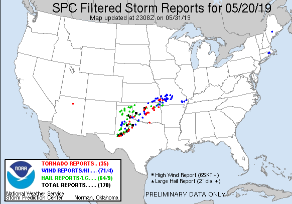
I mean, yes there were some tornadoes in Oklahoma but so far they haven't been nailed yet. The area between Abilene and Midland looks pretty bad right now though
-
Texaspirate11

- Posts: 1278
- Joined: Tue Dec 31, 2013 12:24 am
- Contact:
Wind is howling down here by the bay...feeding all that energy up
Just because you're disabled, you don't have to be a victim
Be Weather Aware & Prepared!
Barbara Jordan Winner in Media
Disability Integration Consultant
Be Weather Aware & Prepared!
Barbara Jordan Winner in Media
Disability Integration Consultant
And now the bad stuff is starting to blow up. Late night tornadoes have to be pretty damned terrifying.

Yeah, it’s not over yet. It’s gonna be a long night for those folks...
-
tireman4

- Global Moderator

- Posts: 4515
- Joined: Wed Feb 03, 2010 9:24 pm
- Location: Humble, Texas
- Contact:
00
FXUS64 KHGX 211544
AFDHGX
Area Forecast Discussion
National Weather Service Houston/Galveston TX
1044 AM CDT Tue May 21 2019
.DISCUSSION...
A couple lines of weak precipitation moving into the CWFA from the
W/NW this morning seem to be holding together as they move further
E with time. The initial line (outflow?) should weaken as it moves
through the area...but will have to keep an eye on the second line
as near-term models/morning soundings are indicating a decent pot-
ential for strong thunderstorms this afternoon. Locations north of
I-10 should see the highest POPs with much lower numbers closer to
the coast (where the cap seems to be stronger). Current grids seem
to be on track, so not planning on a lot (if any) changes with the
update. 41
&&
.PREV DISCUSSION... /ISSUED 437 AM CDT Tue May 21 2019/
Many hazards to consider today; from strong gradient winds to
potential strong northern county thunderstorms. The east-to-west
synoptic pressure gradient between GA-FL high pressure and
western Texas low pressure is the tightest across eastern Texas
this morning. This is producing early day 20 to 30 mph sustained
southeasterly winds with gusts approaching 35 to 40 mph over a
good western 2/3rds of the forecast area including the immediate
coastline. These winds have prompted a Wind Advisory that will be
in effect through 6 PM this evening. This healthy long duration
onshore fetch will push Gulf and Bay water onto local beachfronts
and there will coastal flooding issues during high tide times
(please see Marine section below). A Coastal Flood Warning is in
effect through 6 PM for the Galveston Bay area with a Coastal
Flood Advisory for western coastal region down shore of the San
Luis Pass. A line of Central Texas thunderstorms will be entering
our warm and conditionally unstable environment this afternoon.
There is a marginal chance that isolated thunderstorms could reach
strong to severe thresholds and produce short duration, limited
coverage damaging downburst winds and large hail. If discrete
cells do form just ahead of the main line late this morning, there
will be enough uni-directional shear energy with height to open a
small window of opportunity for tornadoes.
The main line of thunderstorms will be encountering a more stable
air mass over the southern 2/3rds of the CWA. Prog and AMDAR
aircraft sounding reports depict quite the robust, deep warm
layer with decent near 7 C/km lapse rates above 700 mb. If
surface temperatures across the northern third of the forecast
area can achieve the lower 80s before noon this could erode this
warm nose enough for frontogenesis-induced lift to tap into this
higher CAPE column. Early day overcast will inhibit warming `but`
sunrise temperatures will be within 5 degrees of convective
temperatures. For what is it is worth, all models are showing
strong enough frontal forcing to suggest enough ascent to sustain
or initiate downstream thunderstorms north of the city early this
afternoon. Higher confidence of strong thunderstorms to impact
the far northern tier of counties from Brazos County over to
Houston County with developing storms south of these communities
struggling to maintain enough structure to pose much of a threat.
As column winds veer more parallel with the mean flow this loss of
bulk shear, in tandem with more stout southern CWA capping, has
focused this early afternoon marginal severe threat north of a
Brenham to Huntsville to Livingston line.
Once today`s storms travel east of the region, we will not be
visited by any significant precipitation for several days.
Surface to upper ridging builds in from the east through the
remainder of the week and this will shut off any mention of
rain/convection. Other than early day streamer showers over our
southern/coastal counties, days will be sunny enough to warm the
region to around 90 F each subsequent day through early next
week...minimum temperatures in the average middle to upper 70s.
The only deviation in overnight temperatures will come from (late
week) periods of slightly drier air advecting in on southeasterly
steering flow. Onshore winds will remain in the moderate realm as
mid-morning through late afternoon interior western forecast area
and coastal winds regularly strengthen to 15 to 25 mph through
the remainder of the work week. These winds will aid in mixing
down some drier mid layer air thus regulating afternoon apparent
temperatures to the lower 90s, or a few degrees warmer than
ambient temperatures. 31
&&
.PRELIMINARY POINT TEMPS/POPS...
College Station (CLL) 86 74 91 75 92 / 60 10 10 10 10
Houston (IAH) 88 77 89 76 90 / 30 20 0 10 10
Galveston (GLS) 85 79 85 78 85 / 10 10 10 10 10
&&
.HGX WATCHES/WARNINGS/ADVISORIES...
TX...Coastal Flood Warning until 6 PM CDT this evening for the
following zones: Brazoria Islands...Chambers...Coastal
Galveston...Coastal Harris...Galveston Island and Bolivar
Peninsula.
Wind Advisory until 6 PM CDT this evening for the following
zones: Austin...Brazos...Burleson...Chambers...Coastal
Brazoria...Coastal Galveston...Coastal Harris...Coastal
Jackson...Coastal Matagorda...Colorado...Fort Bend...
Galveston Island and Bolivar Peninsula...Grimes...Houston...
Inland Brazoria...Inland Galveston...Inland Harris...Inland
Jackson...Inland Matagorda...Madison...Matagorda Islands...
Montgomery...Walker...Waller...Washington...Wharton.
Coastal Flood Advisory until 6 PM CDT this evening for the
following zones: Coastal Brazoria...Coastal Jackson...
Coastal Matagorda.
Coastal Flood Advisory from 6 PM this evening to 1 PM CDT
Thursday for the following zones: Brazoria Islands...
Galveston Island and Bolivar Peninsula.
Coastal Flood Advisory until 1 PM CDT Thursday for the following
zones: Matagorda Islands.
GM...Small Craft Advisory until 7 PM CDT this evening for the
following zones: Galveston Bay...Matagorda Bay.
Small Craft Advisory until 4 AM CDT Wednesday for the following
zones: Coastal waters from Freeport to Matagorda Ship
Channel TX out 20 NM...Coastal waters from High Island to
Freeport TX out 20 NM...Waters from Freeport to Matagorda
Ship Channel TX from 20 to 60 NM...Waters from High Island
to Freeport TX from 20 to 60 NM.
&&
$$
I’m at 88 degrees, will probably hit 90. NWS said cap would be breakable with low-80’s. Question is: will it actually happen?
12z GFS offers a bit of hope the last couple days of the month.

Broken line of showers headed through BCS with modest rainfall. Will the line hold up?
90 degrees at the house now. Surely that’s enough heat to bust the cap (or is it???)
A rain cooled 68°F here. Enjoy it while it lasts!
I have a week or two to fix a couple sections of the sprinkler system.
I have a week or two to fix a couple sections of the sprinkler system.
It’s still a broken line of showers. No thunderbolts yet on RadarScope. I don’t want severe weather - I just want a good 1/2” of rain to keep the lawn watered until Saturday. I need to replace a leak and a few sprinkler heads as well until I can use sprinklers.
I would like at least a little rain to keep the dust settled. That’s all I ask for at this moment lol
-
redneckweather
- Posts: 1023
- Joined: Mon Feb 08, 2010 7:29 pm
- Location: Montgomery, Texas
- Contact:
Not going to happen.jasons wrote: ↑Tue May 21, 2019 2:05 pm It’s still a broken line of showers. No thunderbolts yet on RadarScope. I don’t want severe weather - I just want a good 1/2” of rain to keep the lawn watered until Saturday. I need to replace a leak and a few sprinkler heads as well until I can use sprinklers.
Looks pretty weaksauce on radar.
0.00”