
Horrible day/night for Okla and Mo City - 8 years to the day of the Joplin, mo tornado....unome wrote: ↑Thu May 23, 2019 1:17 amJefferson City also
https://www.broadcastify.com/listen/ctid/1504
https://www.weather.gov/lsx/
https://twitter.com/iembot_lsx
https://mesonet.agron.iastate.edu/lsr/# ... 40459/0100
https://twitter.com/bhensonweather
https://twitter.com/gdimeweather
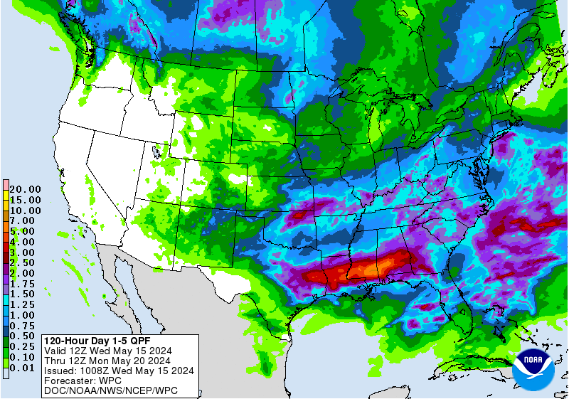
MAY 2019: Wednesday Storm Complex/Scattered Showers To End May
-
Texaspirate11

- Posts: 1278
- Joined: Tue Dec 31, 2013 12:24 am
- Contact:
Just because you're disabled, you don't have to be a victim
Be Weather Aware & Prepared!
Barbara Jordan Winner in Media
Disability Integration Consultant
Be Weather Aware & Prepared!
Barbara Jordan Winner in Media
Disability Integration Consultant
Dry lines and fronts can do wonders with as much moisture inflow that's being pumped over our area and up north. Makes for a much livelier storm season, to say the least.jasons wrote: ↑Wed May 22, 2019 7:40 pm It's amazing to me how much action they get up in the semi-arid Panhandle and SW Oklahoma, but that same inflow down here along the coast is too dry and capped for anything. Not wishing for severe weather, but a clap of thunder with some rainfall would be welcome.
-
tireman4

- Global Moderator

- Posts: 4488
- Joined: Wed Feb 03, 2010 9:24 pm
- Location: Humble, Texas
- Contact:
The forecast, to which Jeff and Steve have alluded to in their forecasts...
000
FXUS64 KHGX 230915
AFDHGX
Area Forecast Discussion
National Weather Service Houston/Galveston TX
415 AM CDT Thu May 23 2019
.DISCUSSION...
Southeastern Texas getting clipped by a Central Texas near 40
knot low level jet. Our regional morning 30 knot lower layer
winds have translated to 15 to 25 (gust 35) knot surface winds,
especially strongest across the coastal counties. These gusty
overnight winds have prompted a Wind Advisory for the immediate
coastline through 10 AM. Water vapor imagery may be picking up on
a small weak disturbance moving into the northern reaches of the
Mexican Provinces of Nuevo Leon and Tamaulipas. This disturbance
may work its way up into southern Texas and reach our far western
zones around Matagorda Bay later this morning. If so, it may
provide enough lift within a conditionally unstable and highly
moist (near 1.7 inch pwat) environment surrounding Matagorda Bay
that, in tandem with a weakening low level 25 knot jet, to
initiate scattered showers and maybe that rogue thunderstorm.
Slight to low end chance POPS for slowly north and eastern
propagating cells along and in the vicinity of the Highway
59/Interstate 69 corridor southwest of metro through the
afternoon. This will probably be the last mentionable chance for
rain in a week. Recently amped up winds will fall back to 10 to
15 knot magnitudes during the day, 5 to 10 knot overnight speeds.
Eastern upper ridging centered over the southeastern U.S. is
forecast to expand westward in the coming days and overtake
eastern Texas. Suppression with these higher heights are expected
to envelop the region and nil any appreciable rain chances through
mid next week. A trend towards relatively drier air moving in on
a general southerly steering flow will assist in ending this trend
of record high minimum temperatures; expect average lower to
middle 70 sunrise temperatures. Partially cloudy days will have
more sun making it to the surface and warming many into the
slightly above normal lower 90s each subsequent day through the
period. Slightly lower humidity levels, per more sunshine
assisting in more efficient afternoon mixing, will keep heat
indices in the mean middle 90s, or a few degrees above ambient
afternoon temperatures through late May. Even though sub 100 heat
indices are forecast, it is important to bear in mind that early
warm season heat, with lessened air quality (as more sun creates
higher levels of lower level ozone), can be a silent killer in
terms of heat-related stress and exhaustion. Limit afternoon
activities, stay shaded and hydrated and always check your
vechicle`s backseat for the little ones. 31
&&
.MARINE...
Moderate onshore flow will persist today and tonight. Will keep the
current configuration of advsy flags in place, though the day shift
may be able to downgrade some locations to caution later today.
Overall trend should be for slightly lower winds/seas as we head
into the weekend...though marine conditions will probably be rougher
than we`ve seen the past several Memorial Day weekends which will
need to be taken into consideration given the high number of people
expected at area beaches and on the water.
Coastal Flood Advisory will continue along the Gulf facing coast
today. Minor coastal flooding remains a possibility around times of
high tide. The more prone location will be the Highway 87/124
intersection on Bolivar today. Levels have been trending down the
past 24-36 hours. We may be able to make this the last
advisory...and transition to more of a beach hazards product
incorporating the primary issue of being the rip current risk for
the holiday weekend.
Winds/seas build again early next week as the pressure gradient
tightens back up. 47
&&
.AVIATION...
Mix of MVFR/VFR ceilings across the area early this morning. Should
transition into mostly VFR this afternoon. There will probably be
some iso shra around, but not planning to include any VCSH wording
attm and let amendments take care of those if need be. Ceilings
should lower back down into MVFR territory this evening. 12z TAF
package should look similar to what`s already out. 47
&&
.PRELIMINARY POINT TEMPS/POPS...
College Station (CLL) 91 75 92 74 91 / 10 0 0 0 0
Houston (IAH) 91 76 92 75 91 / 20 0 0 0 0
Galveston (GLS) 86 79 88 79 85 / 10 0 0 0 0
&&
.HGX WATCHES/WARNINGS/ADVISORIES...
TX...Wind Advisory until 10 AM CDT this morning for the following
zones: Brazoria Islands...Chambers...Coastal Brazoria...
Coastal Galveston...Coastal Jackson...Coastal Matagorda...
Galveston Island and Bolivar Peninsula...Matagorda Islands.
Coastal Flood Advisory until 5 PM CDT this afternoon for the
following zones: Brazoria Islands...Galveston Island and
Bolivar Peninsula...Matagorda Islands.
GM...Small Craft Advisory until 7 AM CDT Friday for the following
zones: Coastal waters from Freeport to Matagorda Ship
Channel TX out 20 NM...Coastal waters from High Island to
Freeport TX out 20 NM...Matagorda Bay...Waters from
Freeport to Matagorda Ship Channel TX from 20 to 60 NM...
Waters from High Island to Freeport TX from 20 to 60 NM.
Small Craft Advisory until 10 AM CDT this morning for the
following zones: Galveston Bay.
&&
$$
Discussion...31/47

NOAA has come out with their 2019 Hurricane Forecast. Predicting near-normal season. More info in link -
https://www.noaa.gov/media-release/noaa ... ane-season
https://www.noaa.gov/media-release/noaa ... ane-season
- Attachments
-
Blake
Boomer Sooner
Boomer Sooner
-
tireman4
- Global Moderator
- Posts: 4488
- Joined: Wed Feb 03, 2010 9:24 pm
- Location: Humble, Texas
- Contact:
00
FXUS64 KHGX 231647
AFDHGX
Area Forecast Discussion
National Weather Service Houston/Galveston TX
1147 AM CDT Thu May 23 2019
.AVIATION...
MVFR rising to VFR quickly by afternoon except near the coast. LLJ
over the western areas this morning should help keep it breezy
today with SE winds 13-17g18-25kt. MVFR deck developing and
expanding quickly inland this evening and continuing through mid
morning. LLJ to the west of the region tonight will keep winds up
tonight but it is a little further west and weaker so slightly
lighter winds. Nearly rinse and repeat for the tafs with
persistence.
45
&&
.PREV DISCUSSION... /ISSUED 1053 AM CDT Thu May 23 2019/
UPDATE...
General concept of the forecast is on track, with biggest changes
being to nudge up southerly winds to better track with
observations as well as giving a bit of a re-ramp PoPs in the
west to line up with radar trends as a few sprinkles are beginning
to pop up in Jackson and Wharton County.

Closer to home, there are some quick-moving showers out there. NWS has upped my POPs up to 30% today.

-
tireman4
- Global Moderator
- Posts: 4488
- Joined: Wed Feb 03, 2010 9:24 pm
- Location: Humble, Texas
- Contact:
000
FXUS64 KHGX 240920
AFDHGX
Area Forecast Discussion
National Weather Service Houston/Galveston TX
420 AM CDT Fri May 24 2019
.DISCUSSION...
Forecast of persistence looks tough to beat thru the holiday
weekend. Pattern will generally consist of a southeastern U.S.
ridge and a western trof. We`ll be situated closer to the
periphery of the ridge and its associated subsidence should limit
overall chances of precipitation (though can`t totally rule out
some streamer type shra from time to time). So, in general, look
for late night and morning cloudiness followed by pcldy days with
lows in the 70s and highs around 90.
Early next week, a shortwave will drop into the base of the trof
and eject northeast from the Four Corners area toward the Great
Lakes Tue and Wed. This should somewhat flatten the ridge as this
occurs and send a frontal boundary into Texas during the midweek
time period. This front should eventually lose its southward support
and stall somewhere near or north of southeast Texas. It`ll be
the next focus for decent shra/tstm chances, but until confidence
increases as to where the boundary ends up we`ll be keeping POPs
topped out around 30% for northern zones for the time being. 47
&&
.MARINE...
The strong onshore winds of the last few days will continue to de-
crease through the weekend. Will maintain the Small Craft Advisory
for the offshore waters through today, as seas slowly subside. The
nearshore waters and Matagorda Bay will see Caution conditions for
winds today. Otherwise, the forecast for the weekend should remain
similar to that of today - generally moderate onshore winds across
the bays/nearshore waters and slightly stronger winds over the off
shore waters. However, despite the decreased SE winds, the Coastal
Flood Advisory will likely continue as the onshore fetch persists.
Minor coastal flooding with wave run-up remain possible (especial-
ly during high tides) for Gulf facing locations. Additionally, the
surf will remain elevated to rough at times...with strong rip cur-
rents a concern given the increase in beach goers for this holiday
weekend. 41
&&
.AVIATION...
Brief MVFR CIGS are still expected this morning...with SCT/BKN VFR
decks expected this afternoon. We should see a return of MVFR CIGS
and ISO weak WAA showers across SE TX this evening/overnight given
the persistent onshore flow. Not a lot of changes are expected un-
til the start of next week. 41
&&
.PRELIMINARY POINT TEMPS/POPS...
College Station (CLL) 91 73 90 74 91 / 0 0 0 10 0
Houston (IAH) 90 75 90 74 91 / 10 0 0 0 0
Galveston (GLS) 86 79 86 78 87 / 10 10 10 10 10
&&
.HGX WATCHES/WARNINGS/ADVISORIES...
TX...SMALL CRAFT SHOULD EXERCISE CAUTION from 7 AM CDT this morning
through this evening for the following zones: Matagorda
Islands.
GM...Small Craft Advisory until 7 AM CDT this morning for the
following zones: Coastal waters from Freeport to Matagorda
Ship Channel TX out 20 NM...Coastal waters from High Island
to Freeport TX out 20 NM...Matagorda Bay.
SMALL CRAFT SHOULD EXERCISE CAUTION from 7 AM CDT this morning
through this evening for the following zones: Coastal
waters from Freeport to Matagorda Ship Channel TX out 20
NM...Coastal waters from High Island to Freeport TX out 20
NM...Matagorda Bay.
SMALL CRAFT SHOULD EXERCISE CAUTION through this evening for the
following zones: Galveston Bay.
Small Craft Advisory until 7 PM CDT this evening for the
following zones: Waters from Freeport to Matagorda Ship
Channel TX from 20 to 60 NM...Waters from High Island to
Freeport TX from 20 to 60 NM.
&&
$$
-
tireman4
- Global Moderator
- Posts: 4488
- Joined: Wed Feb 03, 2010 9:24 pm
- Location: Humble, Texas
- Contact:
00
FXUS64 KHGX 241647
AFDHGX
Area Forecast Discussion
National Weather Service Houston/Galveston TX
1147 AM CDT Fri May 24 2019
.AVIATION...
VFR for almost all of our TAF sites this afternoon (could see some lingering
MVFR ceilings near the coast). A mix of VFR and MVFR ceilings/visibilities
anticipated to develop again tonight, and with some lighter winds the
MVFR levels might win out. Increasing winds tomorrow morning are expected
to lift and mix any of the lower cloud development. VFR again for almost
all of our TAF sites tomorrow afternoon. 42
&&
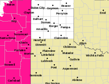
panhandle just can't catch a break
https://www.weather.gov/lub/
https://www.weather.gov/wwamap/png/lub.png
https://radar.weather.gov/lite/N0R/LBB_loop.gif
https://www.weather.gov/lub/
https://www.weather.gov/wwamap/png/lub.png
https://radar.weather.gov/lite/N0R/LBB_loop.gif

A very stubborn trough and ridge is leading to atmospheric instability and conflict in the same place. Almost a summer-like Texas death ridge in the Southeast. Early and the season and east of normal.unome wrote: ↑Fri May 24, 2019 2:14 pm panhandle just can't catch a break
https://www.weather.gov/lub/
https://www.weather.gov/wwamap/png/lub.png
https://radar.weather.gov/lite/N0R/LBB_loop.gif
Windy and muggy here. We were down in Houston yesterday, and it felt a considerably cooler near Hobby than in the Memorial City area or definitely College Station.
I really hate it when the grass starts drying out, yet it still is humid as hell with a dew point approaching the mid 70s! Must. Resist. Watering. However, the probability of rain is low until Thursday. &^*%@#$%!
love the humor & wit of our local NWS
It's been 12 hours since the last time I sat here writing the
forecast discussion, and I'll be honest with you - I spent a brief
moment wondering if I could copy and paste the afternoon AFD and
see if anyone noticed. Anyway, here's some thoughts on the
Memorial Day weekend.
-
Texaspirate11
- Posts: 1278
- Joined: Tue Dec 31, 2013 12:24 am
- Contact:
Luchs is the best writer there
Just because you're disabled, you don't have to be a victim
Be Weather Aware & Prepared!
Barbara Jordan Winner in Media
Disability Integration Consultant
Be Weather Aware & Prepared!
Barbara Jordan Winner in Media
Disability Integration Consultant
-
srainhoutx

- Site Admin

- Posts: 19616
- Joined: Tue Feb 02, 2010 2:32 pm
- Location: Maggie Valley, NC
- Contact:
The pesky upper air pattern that has brought day after day Severe Weather and Flooding across portions of the Plains and the Mid West shows signs of breaking down. It appears we will finally transition from a Western Trough/SE Heat Ridge to that of a more typical quazi zonal flow as May ends.
Wednesday looks to be a bit active across North Texas into Oklahoma as a thunderstorm complex develops and moves E to ESE. A frontal boundary now looks like it will approach SE Texas Wednesday night and a cool pool aloft associated with that dying thunderstorm complex offers a chance of scattered shower and thunderstorms on Thursday. The boundary should wash out on Friday as we end the month and begin June. Time for a new Topic. It's Hurricane Season again!
Wednesday looks to be a bit active across North Texas into Oklahoma as a thunderstorm complex develops and moves E to ESE. A frontal boundary now looks like it will approach SE Texas Wednesday night and a cool pool aloft associated with that dying thunderstorm complex offers a chance of scattered shower and thunderstorms on Thursday. The boundary should wash out on Friday as we end the month and begin June. Time for a new Topic. It's Hurricane Season again!
- Attachments
-
-
-
Carla/Alicia/Jerry(In The Eye)/Michelle/Charley/Ivan/Dennis/Katrina/Rita/Wilma/Humberto/Ike/Harvey
Member: National Weather Association
Facebook.com/Weather Infinity
Twitter @WeatherInfinity
Member: National Weather Association
Facebook.com/Weather Infinity
Twitter @WeatherInfinity
I’ve been monitoring rain chances for Thursday.
They were 40/40/60 (got excited yesterday) and now 50%.
We’ll see...
They were 40/40/60 (got excited yesterday) and now 50%.
We’ll see...
Happy Memorial day to all of the wxinfinity forum members. Let us not forget the sacrifice of our fallen soldiers.
Man, these weather apps are all lousy. One has my rain chances at 80% Tuesday and the other is at 20%. Wednesday they are flipped. Hopefully we at least can get something going. My St Augustine yard has already thrown in the towel.