General Tropical Discussion Thread

Tropical Weather Discussions and Analysis
User avatar
srainhoutx
Site Admin
Site Admin
Posts: 19620
Joined: Tue Feb 02, 2010 2:32 pm
Location: Maggie Valley, NC
Contact:

Have a Yellow in the Gulf now...

000
ABNT20 KNHC 161735
TWOAT
TROPICAL WEATHER OUTLOOK
NWS TPC/NATIONAL HURRICANE CENTER MIAMI FL
200 PM EDT FRI JUL 16 2010

FOR THE NORTH ATLANTIC...CARIBBEAN SEA AND THE GULF OF MEXICO...

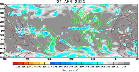
AN AREA OF LOW PRESSURE LOCATED JUST EAST OF SOUTHERN NICARAGUA
CONTINUES TO PRODUCE A LARGE AREA OF DISORGANIZED SHOWERS AND
THUNDERSTORMS. SIGNIFICANT DEVELOPMENT OF THIS SYSTEM IS NOT
EXPECTED DUE TO PROXIMITY TO LAND...HOWEVER HEAVY RAINS WILL
SPREAD OVER PORTIONS OF CENTRAL AMERICA DURING THE NEXT COUPLE OF
DAYS AS THIS SYSTEM MOVES SLOWLY WESTWARD. THERE IS A LOW
CHANCE...10 PERCENT...OF THIS SYSTEM BECOMING A TROPICAL CYCLONE
DURING THE NEXT 48 HOURS.

SHOWERS AND THUNDERSTORMS OVER THE NORTHERN GULF OF MEXICO ARE
ASSOCIATED WITH A TROUGH OF LOW PRESSURE. SURFACE PRESSURES ARE
NOT FALLING SIGNIFICANTLY...AND DEVELOPMENT...IF ANY...WILL BE SLOW
TO OCCUR AS THE SYSTEM MOVES SLOWLY WESTWARD OR WEST-NORTHWESTWARD
OVER THE NEXT COUPLE OF DAYS. THERE IS A LOW CHANCE...10 PERCENT
...OF THIS SYSTEM BECOMING A TROPICAL CYCLONE DURING THE NEXT 48
HOURS.

ELSEWHERE...TROPICAL CYCLONE FORMATION IS NOT EXPECTED DURING THE
NEXT 48 HOURS.

$$
FORECASTER BRENNAN

Image
Carla/Alicia/Jerry(In The Eye)/Michelle/Charley/Ivan/Dennis/Katrina/Rita/Wilma/Humberto/Ike/Harvey

Member: National Weather Association
Facebook.com/Weather Infinity
Twitter @WeatherInfinity
User avatar
wxman57
Global Moderator
Global Moderator
Posts: 2621
Joined: Thu Feb 04, 2010 5:34 am
Location: Southwest Houston (Westbury)
Contact:

Here are a few charts I made. First the current surface analysis with satellite. Definitely shows a surface trof out there and possibly a very weak LLC. However, there is very little convergence in the vicinity of the lower pressure.
Image

Now let's look aloft. Here's a chart with current 500mb heights in 5 meter increments (yellow) and surface pressures in 0.5 mb increments (pink). Definitely a 500 mb trof across the area.
Image

And, finally, the GFS projection for 7PM CDT Saturday (42 hrs from now). Upper-level trof and surface feature moving inland into Texas Saturday night. With minimal convergence now, relatively high pressures offshore and the short time left over water, this system is not likely to develop. Could give us some rain in Texas on Sunday, though.

Image
User avatar
srainhoutx
Site Admin
Site Admin
Posts: 19620
Joined: Tue Feb 02, 2010 2:32 pm
Location: Maggie Valley, NC
Contact:

MJO is looking favorable for the GOM and Caribbean the next 7-10 days.

Image

Image
Carla/Alicia/Jerry(In The Eye)/Michelle/Charley/Ivan/Dennis/Katrina/Rita/Wilma/Humberto/Ike/Harvey

Member: National Weather Association
Facebook.com/Weather Infinity
Twitter @WeatherInfinity
User avatar
srainhoutx
Site Admin
Site Admin
Posts: 19620
Joined: Tue Feb 02, 2010 2:32 pm
Location: Maggie Valley, NC
Contact:

In the 'for what it's worth' department the CMC suggests a storm in the Gulf by hour 144...

Image
Carla/Alicia/Jerry(In The Eye)/Michelle/Charley/Ivan/Dennis/Katrina/Rita/Wilma/Humberto/Ike/Harvey

Member: National Weather Association
Facebook.com/Weather Infinity
Twitter @WeatherInfinity
User avatar
srainhoutx
Site Admin
Site Admin
Posts: 19620
Joined: Tue Feb 02, 2010 2:32 pm
Location: Maggie Valley, NC
Contact:

12Z Para GFS suggests wave currently just W of 50W will make a run at TD/TS status and approach the Bahamas, FL Straits and on into the Eastern Gulf...

Image

Image
Carla/Alicia/Jerry(In The Eye)/Michelle/Charley/Ivan/Dennis/Katrina/Rita/Wilma/Humberto/Ike/Harvey

Member: National Weather Association
Facebook.com/Weather Infinity
Twitter @WeatherInfinity
User avatar
srainhoutx
Site Admin
Site Admin
Posts: 19620
Joined: Tue Feb 02, 2010 2:32 pm
Location: Maggie Valley, NC
Contact:

18Z para GFS suggests a couple of disturbances...

Image
Carla/Alicia/Jerry(In The Eye)/Michelle/Charley/Ivan/Dennis/Katrina/Rita/Wilma/Humberto/Ike/Harvey

Member: National Weather Association
Facebook.com/Weather Infinity
Twitter @WeatherInfinity
User avatar
srainhoutx
Site Admin
Site Admin
Posts: 19620
Joined: Tue Feb 02, 2010 2:32 pm
Location: Maggie Valley, NC
Contact:

TROPICAL WEATHER OUTLOOK
NWS TPC/NATIONAL HURRICANE CENTER MIAMI FL
800 PM EDT SAT JUL 17 2010

FOR THE NORTH ATLANTIC...CARIBBEAN SEA AND THE GULF OF MEXICO...

A BROAD AREA OF LOW PRESSURE...ASSOCIATED WITH A TROPICAL WAVE...IS
CENTERED ABOUT 700 MILES EAST OF THE WINDWARD ISLANDS. THIS SYSTEM
CURRENTLY IS PRODUCING VERY LITTLE SHOWER ACTIVITY...AND
ENVIRONMENTAL CONDITIONS ARE EXPECTED TO BE UNFAVORABLE FOR
SIGNIFICANT DEVELOPMENT FOR THE NEXT COUPLE OF DAYS. THERE IS A
LOW CHANCE...10 PERCENT...OF THIS SYSTEM BECOMING A TROPICAL
CYCLONE DURING THE NEXT 48 HOURS...ALTHOUGH CONDITIONS COULD BECOME
MORE FAVORABLE FOR DEVELOPMENT AFTER THAT.

$$
FORECASTER FRANKLIN

Image
Carla/Alicia/Jerry(In The Eye)/Michelle/Charley/Ivan/Dennis/Katrina/Rita/Wilma/Humberto/Ike/Harvey

Member: National Weather Association
Facebook.com/Weather Infinity
Twitter @WeatherInfinity
User avatar
Paul
Posts: 535
Joined: Wed Feb 03, 2010 11:46 pm
Location: Pearland
Contact:

convection will be there when it gets into the carib. Really soupy attm so should have plenty of moisture to work with. IMO this will be Bonnie by Weds afternoon and entering the GOM thru the Yucatan Channel.
Scott747
Posts: 1489
Joined: Tue Feb 23, 2010 9:56 am
Location: Freeport/Surfside Beach
Contact:

0z parallel is similar to a few of the earlier runs.

Takes it thru the Fla. straits and into the C Gulf and eventually towards the Tx/La. border.
User avatar
Mr. T
Posts: 992
Joined: Wed Feb 03, 2010 4:22 pm
Location: Kingwood
Contact:

Scott747 wrote:0z parallel is similar to a few of the earlier runs.

Takes it thru the Fla. straits and into the C Gulf and eventually towards the Tx/La. border.
let the southerly trend commence!
User avatar
srainhoutx
Site Admin
Site Admin
Posts: 19620
Joined: Tue Feb 02, 2010 2:32 pm
Location: Maggie Valley, NC
Contact:

6Z GFS continues to show development with a track similar to Georges. The area of disturbed weather certainly appears to have a Mid Level Circulation and possibly a LLC as well. NHC has relocated the circulation center to the E of Guadalupe. I suspect we will see an Invest later today or tomorrow. I would not be surprised to see this become our next named storm of the year this week.

Image

Image
Carla/Alicia/Jerry(In The Eye)/Michelle/Charley/Ivan/Dennis/Katrina/Rita/Wilma/Humberto/Ike/Harvey

Member: National Weather Association
Facebook.com/Weather Infinity
Twitter @WeatherInfinity
Hardcoreweather

...
000
NOUS42 KNHC 181515
WEATHER RECONNAISSANCE FLIGHTS
CARCAH, NATIONAL HURRICANE CENTER, MIAMI, FL.
1115 AM EDT SUN 18 JULY 2010
SUBJECT: TROPICAL CYCLONE PLAN OF THE DAY (TCPOD)
VALID 19/1100Z TO 20/1100Z JULY 2010
TCPOD NUMBER.....10-048

I. ATLANTIC REQUIREMENTS
1. NEGATIVE RECONNAISSANCE REQUIREMENTS.
2. SUCCEEDING DAY OUTLOOK: POSSIBLE LOW LEVEL
INVEST NEAR 21.0N 71.5W AT 20/1800Z. BEGIN
6-HRLY FIXES AT 21/0600Z IF SYSTEM DEVELOPS.
User avatar
srainhoutx
Site Admin
Site Admin
Posts: 19620
Joined: Tue Feb 02, 2010 2:32 pm
Location: Maggie Valley, NC
Contact:

18Z para GFS suggests Lafayette to New Orleans...

Image

Image
Carla/Alicia/Jerry(In The Eye)/Michelle/Charley/Ivan/Dennis/Katrina/Rita/Wilma/Humberto/Ike/Harvey

Member: National Weather Association
Facebook.com/Weather Infinity
Twitter @WeatherInfinity
User avatar
srainhoutx
Site Admin
Site Admin
Posts: 19620
Joined: Tue Feb 02, 2010 2:32 pm
Location: Maggie Valley, NC
Contact:

I agree Ed. The Jamaica disturbance appears to have at least some Mid Level Circulation...

Image
Carla/Alicia/Jerry(In The Eye)/Michelle/Charley/Ivan/Dennis/Katrina/Rita/Wilma/Humberto/Ike/Harvey

Member: National Weather Association
Facebook.com/Weather Infinity
Twitter @WeatherInfinity
User avatar
srainhoutx
Site Admin
Site Admin
Posts: 19620
Joined: Tue Feb 02, 2010 2:32 pm
Location: Maggie Valley, NC
Contact:

ZCZC MIATWOAT ALL
TTAA00 KNHC DDHHMM
TROPICAL WEATHER OUTLOOK
NWS TPC/NATIONAL HURRICANE CENTER MIAMI FL
800 PM EDT SUN JUL 18 2010

FOR THE NORTH ATLANTIC...CARIBBEAN SEA AND THE GULF OF MEXICO...

1. A TROPICAL WAVE IN THE VICINITY OF THE LEEWARD ISLANDS CONTINUES TO
PRODUCE DISORGANIZED SHOWERS AND THUNDERSTORMS. ALTHOUGH SURFACE
PRESSURES HAVE FALLEN SLIGHTLY OVER THE AREA...ANY DEVELOPMENT OF
THIS DISTURBANCE IS LIKELY TO BE SLOW TO OCCUR AS IT MOVES WEST-
NORTHWESTWARD AT ABOUT 15 MPH. THERE IS A LOW CHANCE...10
PERCENT...OF THIS SYSTEM BECOMING A TROPICAL CYCLONE DURING THE
NEXT 48 HOURS. REGARDLESS OF DEVELOPMENT...GUSTY WINDS AND LOCALLY
HEAVY RAINFALL ASSOCIATED WITH THIS SYSTEM COULD AFFECT THE LEEWARD
ISLANDS...THE VIRGIN ISLANDS...PUERTO RICO...THE DOMINICAN
REPUBLIC...HAITI...AND THE TURKS AND CAICOS ISLANDS DURING THE NEXT
COUPLE OF DAYS.

2. ANOTHER TROPICAL WAVE IS PRODUCING SHOWERS AND THUNDERSTORMS OVER
PORTIONS OF THE CENTRAL CARIBBEAN SEA. THERE ARE NO SIGNS OF A
SURFACE CIRCULATION IN THIS AREA AND DEVELOPMENT...IF ANY...OF THIS
DISTURBANCE SHOULD BE SLOW TO OCCUR AS IT MOVES GENERALLY WESTWARD
AT 10 TO 15 MPH. THERE IS A LOW CHANCE...10 PERCENT...OF THIS
SYSTEM BECOMING A TROPICAL CYCLONE DURING THE NEXT 48 HOURS.

ELSEWHERE...TROPICAL CYCLONE FORMATION IS NOT EXPECTED DURING THE
NEXT 48 HOURS.

$$
FORECASTER PASCH
Carla/Alicia/Jerry(In The Eye)/Michelle/Charley/Ivan/Dennis/Katrina/Rita/Wilma/Humberto/Ike/Harvey

Member: National Weather Association
Facebook.com/Weather Infinity
Twitter @WeatherInfinity
User avatar
Paul
Posts: 535
Joined: Wed Feb 03, 2010 11:46 pm
Location: Pearland
Contact:

I would not underestimate the SE high building in the long term. This is July after all. The EURO has a pretty stout high at around 196hr in the SE. I am referring to the soon to be Invest near PR. A katrina like track through the straits is not out of the question but not a NGOM issue with a building high.......the one around Jamaica looks like a Alex track....JMO

We wait for the EURO to latch on to developement then we look at track....waiting game...


BTW- good to be back on the Ch11 forum...been taking a break from you guys.... :D
User avatar
srainhoutx
Site Admin
Site Admin
Posts: 19620
Joined: Tue Feb 02, 2010 2:32 pm
Location: Maggie Valley, NC
Contact:

Impressive wave off Africa...

Image
Carla/Alicia/Jerry(In The Eye)/Michelle/Charley/Ivan/Dennis/Katrina/Rita/Wilma/Humberto/Ike/Harvey

Member: National Weather Association
Facebook.com/Weather Infinity
Twitter @WeatherInfinity
User avatar
srainhoutx
Site Admin
Site Admin
Posts: 19620
Joined: Tue Feb 02, 2010 2:32 pm
Location: Maggie Valley, NC
Contact:

Very impressive wave over Central Africa with significant rotation...

Image
Carla/Alicia/Jerry(In The Eye)/Michelle/Charley/Ivan/Dennis/Katrina/Rita/Wilma/Humberto/Ike/Harvey

Member: National Weather Association
Facebook.com/Weather Infinity
Twitter @WeatherInfinity
User avatar
srainhoutx
Site Admin
Site Admin
Posts: 19620
Joined: Tue Feb 02, 2010 2:32 pm
Location: Maggie Valley, NC
Contact:

NHC may throw up a Yellow for the disturbance in the BoC. Certainly looks more organized this afternoon. It should be inland in MX in 24-36 hours...

Image
Carla/Alicia/Jerry(In The Eye)/Michelle/Charley/Ivan/Dennis/Katrina/Rita/Wilma/Humberto/Ike/Harvey

Member: National Weather Association
Facebook.com/Weather Infinity
Twitter @WeatherInfinity
Scott747
Posts: 1489
Joined: Tue Feb 23, 2010 9:56 am
Location: Freeport/Surfside Beach
Contact:

18z GFS parallel still suggests something coming up from the NW Caribbean and heading towards our neck of the woods.

Euro has also been suggesting some disturbed weather in the Caribbean as well during the same time frame.
Post Reply
  • Information
  • Who is online

    Users browsing this forum: No registered users and 56 guests