February Weather Discussion. Wild Winter Storms?

General Weather Discussions and Analysis
User avatar
srainhoutx
Site Admin
Site Admin
Posts: 19616
Joined: Tue Feb 02, 2010 2:32 pm
Location: Maggie Valley, NC
Contact:

Interesting that the PNA continues to rise and not decline...

Image

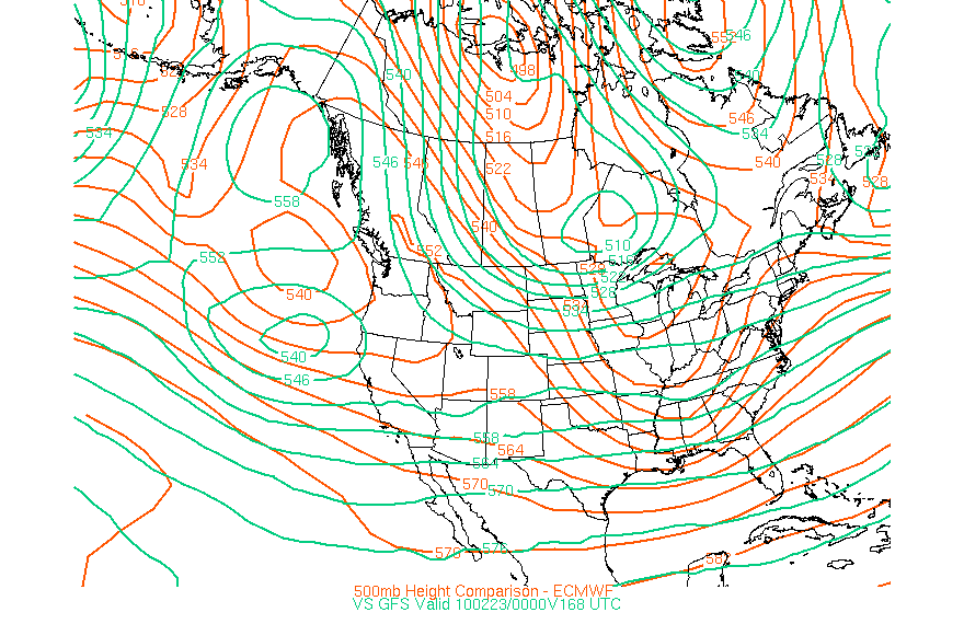
Also note the spread between the GFS and the ECMWF at hour 168...

Image
Carla/Alicia/Jerry(In The Eye)/Michelle/Charley/Ivan/Dennis/Katrina/Rita/Wilma/Humberto/Ike/Harvey

Member: National Weather Association
Facebook.com/Weather Infinity
Twitter @WeatherInfinity
txsnowmaker
Posts: 632
Joined: Wed Feb 03, 2010 4:07 pm
Location: SW Houston (Galleria area)
Contact:

Can someone explain what the latest UKMET model is showing for Texas (especially for our area) early-mid next week? This seems to have generated some interest from Texans in other forums...
User avatar
srainhoutx
Site Admin
Site Admin
Posts: 19616
Joined: Tue Feb 02, 2010 2:32 pm
Location: Maggie Valley, NC
Contact:

txsnowmaker wrote:Can someone explain what the latest UKMET model is showing for Texas (especially for our area) early-mid next week? This seems to have generated some interest from Texans in other forums...
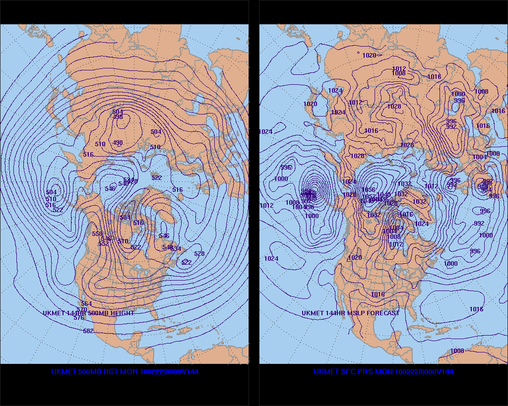
A bit too soon to tell as it only goes out to hour 144. With that said, the the 500mb flow does show a somewhat cross polar flow with an Upper Air disturbance riding S along the lee side of the Rockies in the NW flow aloft. We shall see....

Image
Carla/Alicia/Jerry(In The Eye)/Michelle/Charley/Ivan/Dennis/Katrina/Rita/Wilma/Humberto/Ike/Harvey

Member: National Weather Association
Facebook.com/Weather Infinity
Twitter @WeatherInfinity
User avatar
kayci
Posts: 358
Joined: Thu Feb 04, 2010 10:30 am
Location: Alvin
Contact:

Ed Mahmoud wrote:T'was nippy this morning.


I can remember recent light freezes, even in March, and we may or may not get more cold weather, but I think the window is closing on Winter Weather Miracle season.

one could only hope.....
txsnowmaker
Posts: 632
Joined: Wed Feb 03, 2010 4:07 pm
Location: SW Houston (Galleria area)
Contact:

Thanks for the UKMET analysis srain. Will be interesting to see how the last week in February shapes up.
User avatar
srainhoutx
Site Admin
Site Admin
Posts: 19616
Joined: Tue Feb 02, 2010 2:32 pm
Location: Maggie Valley, NC
Contact:

Ed Mahmoud wrote:Hey, where can I find UK Met data out to 144 hours.


Inquiring minds and all...
http://www.meteo.psu.edu/~gadomski/UKHE ... kloop.html

Also of note is the Pacific RECON scheduled. G-IV from Japan and C-130 from Anchorage. (Issued yesterday)...so there is a lot of interest concerning the 'potential' of a winter storm. ;)

000
NOUS42 KNHC 151745
WEATHER RECONNAISSANCE FLIGHTS
CARCAH, NATIONAL HURRICANE CENTER, MIAMI, FL.
1245 PM EST MON 15 FEBRUARY 2010
SUBJECT: WINTER STORM PLAN OF THE DAY (WSPOD)
VALID 16/1100Z TO 17/1100Z FEBRUARY 2010
WSPOD NUMBER.....09-077

I. ATLANTIC REQUIREMENTS
1. NEGATIVE RECONNAISSANCE REQUIREMENTS.
2. SUCCEEDING DAY OUTLOOK.....NEGATIVE

II. PACIFIC REQUIREMENTS
1. FLIGHT ONE - TEAL 70
A. P29/ 37.5N 146.8W/ 17/1200Z
B. AFXXX 30WSC TRACK29
C. 17/0600Z
D. 18 DROPS ON TRACK
E. AS HIGH AS POSSIBLE/ 17/1800Z

2. OUTLOOK FOR SUCCEEDING DAY:
FLIGHT ONE - TEAL 71
A. P29/ 37.5N 146.8W/ 18/1200Z

FLIGHT TWO - NOAA 49
A. P99/ TBD/ 18/1200Z
JWP
Carla/Alicia/Jerry(In The Eye)/Michelle/Charley/Ivan/Dennis/Katrina/Rita/Wilma/Humberto/Ike/Harvey

Member: National Weather Association
Facebook.com/Weather Infinity
Twitter @WeatherInfinity
User avatar
srainhoutx
Site Admin
Site Admin
Posts: 19616
Joined: Tue Feb 02, 2010 2:32 pm
Location: Maggie Valley, NC
Contact:

Ed Mahmoud wrote:Thanks.


I wonder why the UK Met in the 'regular' part of the e-Wall only goes 72 hours.
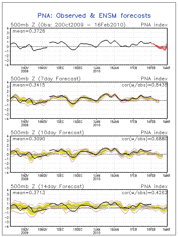
Also of note Ed, is that the UKMET is second in 'verifcation' behind the EC so far this winter.
Carla/Alicia/Jerry(In The Eye)/Michelle/Charley/Ivan/Dennis/Katrina/Rita/Wilma/Humberto/Ike/Harvey

Member: National Weather Association
Facebook.com/Weather Infinity
Twitter @WeatherInfinity
User avatar
srainhoutx
Site Admin
Site Admin
Posts: 19616
Joined: Tue Feb 02, 2010 2:32 pm
Location: Maggie Valley, NC
Contact:

12Z GGEM at hour 144...appears to be some changes in the works...

Image
Carla/Alicia/Jerry(In The Eye)/Michelle/Charley/Ivan/Dennis/Katrina/Rita/Wilma/Humberto/Ike/Harvey

Member: National Weather Association
Facebook.com/Weather Infinity
Twitter @WeatherInfinity
User avatar
wxman57
Global Moderator
Global Moderator
Posts: 2621
Joined: Thu Feb 04, 2010 5:34 am
Location: Southwest Houston (Westbury)
Contact:

Here's a 0-180hr meteogram from the 12Z GFS. Looking like a mild weekend for a change. 54-74 on Sunday would be quite pleasant compared to last Saturday. Long range indicators continue to hint at another major cold outbreak next week, but it's not seen by the operational GFS. Euro does see the cold air in Canada in 6-7 days.

Image
txsnowmaker
Posts: 632
Joined: Wed Feb 03, 2010 4:07 pm
Location: SW Houston (Galleria area)
Contact:

FYI--Channel 13 just mentioned arctic air "fresh from Siberia" making its way south next week all the way into Texas (to which he added, 'we'll see how far south'), with potential record setting lows across much of the US.
User avatar
wxman57
Global Moderator
Global Moderator
Posts: 2621
Joined: Thu Feb 04, 2010 5:34 am
Location: Southwest Houston (Westbury)
Contact:

You can see the Arctic air on this animation of the 850mb ECMWF temperatures. Look at the bright red/orange/yellow air in Canada on the last panel. I see a -36C temperature in there.

http://weather.cod.edu/forecast/loop.ecmwf850t.html
ticka1
Posts: 1265
Joined: Wed Feb 03, 2010 3:02 pm
Location: Baytown/Mont Belvieu
Contact:

Music to my ears Wxman - I just need a weekend with warmer temps and sunshine. I am getting a little stir crazy being inside all the time.

Ancipation for the big cold again at the end of the month....for us in SE Texas.
User avatar
srainhoutx
Site Admin
Site Admin
Posts: 19616
Joined: Tue Feb 02, 2010 2:32 pm
Location: Maggie Valley, NC
Contact:

The 12Z ECMWF now brings some Cold Air S through TX in the 144-168 hour range. Looks like some wintry precip possible for N TX and OK as well...

http://www.meteo.psu.edu/~gadomski/ECMW ... floop.html
Carla/Alicia/Jerry(In The Eye)/Michelle/Charley/Ivan/Dennis/Katrina/Rita/Wilma/Humberto/Ike/Harvey

Member: National Weather Association
Facebook.com/Weather Infinity
Twitter @WeatherInfinity
User avatar
Portastorm
Posts: 800
Joined: Wed Feb 03, 2010 3:04 pm
Location: Southwest Austin/Oak Hill, TX
Contact:

Here's a great line from NWSFO Houston/Galveston's afternoon AFD:

DIDN`T CHANGE MUCH IN THE EXTENDED PORTION YET AS
WE`D PROBABLY JUST BE SWATTING AT FLIES THIS FAR OUT. WOULD PREFER
TO SEE A COUPLE OF MORE CONSISTENT RUN-TO-RUN MODELS FOR CONSISTENCY
SAKE.

:lol:
sleetstorm
Posts: 651
Joined: Thu Feb 04, 2010 12:33 pm
Contact:

As it stands, wintry precip. is not being shown on any of the models to fall in southeast Texas during sometime next week regardless of the feasibility that it could very well come about, right?
User avatar
wxdata
Site Admin
Site Admin
Posts: 1059
Joined: Wed Feb 03, 2010 3:04 pm
Location: Houston, TX
Contact:

If the forecast holds, this would be interesting!
User avatar
wxman57
Global Moderator
Global Moderator
Posts: 2621
Joined: Thu Feb 04, 2010 5:34 am
Location: Southwest Houston (Westbury)
Contact:

Looks like just a deepening trof across Texas from hr 216 to 240, Ed.
User avatar
srainhoutx
Site Admin
Site Admin
Posts: 19616
Joined: Tue Feb 02, 2010 2:32 pm
Location: Maggie Valley, NC
Contact:

sleetstorm wrote:As it stands, wintry precip. is not being shown on any of the models to fall in southeast Texas during sometime next week regardless of the feasibility that it could very well come about, right?
Nothing yet sleet. But you hang in there. Some mighty cold air is expected to build into Canada from Siberia. Who knows, it may just head south before winter’s last gasp. Then it will be time to watch for severe weather as we head into Spring.
Carla/Alicia/Jerry(In The Eye)/Michelle/Charley/Ivan/Dennis/Katrina/Rita/Wilma/Humberto/Ike/Harvey

Member: National Weather Association
Facebook.com/Weather Infinity
Twitter @WeatherInfinity
txsnowmaker
Posts: 632
Joined: Wed Feb 03, 2010 4:07 pm
Location: SW Houston (Galleria area)
Contact:

wxdata wrote:If the forecast holds, this would be interesting!

Thanks wxdata. Someone in another forum commented on this image, saying that it indicates the possibility of wintry precip developing NORTH of the low along the Texas coast, which would leave our area out of the fun. In your opinion, is that an accurate interpretation of this graphic?
User avatar
srainhoutx
Site Admin
Site Admin
Posts: 19616
Joined: Tue Feb 02, 2010 2:32 pm
Location: Maggie Valley, NC
Contact:

00Z's have started. Maybe the 'night crew' will have some input... :mrgreen:

http://wxweb.meteostar.com/models/noaap ... UMBLOOP=10
Carla/Alicia/Jerry(In The Eye)/Michelle/Charley/Ivan/Dennis/Katrina/Rita/Wilma/Humberto/Ike/Harvey

Member: National Weather Association
Facebook.com/Weather Infinity
Twitter @WeatherInfinity
Post Reply
  • Information
  • Who is online

    Users browsing this forum: Ahrefs [Bot], Bing [Bot] and 65 guests