
Hey Aggiebuckeye--where do you pull your information? The models don't verify your forecast. The weather service doesn't seem to agree. The 850 temps don't agree with you and neither does anything else. Maybe an inch in the northern burbs? I'm thinking an inch in the southern burbs...
Welcome to the forum..
February Weather Discussion. Wild Winter Storms?
-
TexasMetBlake
- Pro Met

- Posts: 839
- Joined: Wed Feb 03, 2010 7:03 pm
- Location: Spring/Woodlands
- Contact:
-
srainhoutx

- Site Admin

- Posts: 19616
- Joined: Tue Feb 02, 2010 2:32 pm
- Location: Maggie Valley, NC
- Contact:
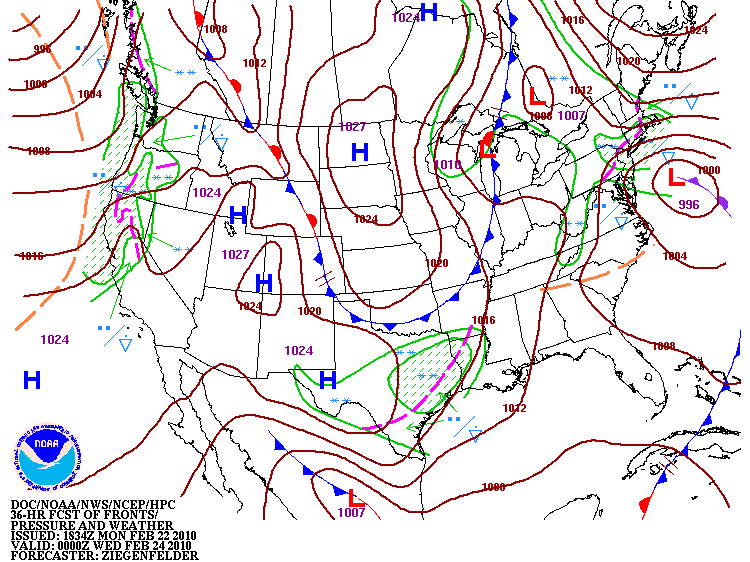
Updated 18Z surface Analysis for 00Z Wednesday...
Carla/Alicia/Jerry(In The Eye)/Michelle/Charley/Ivan/Dennis/Katrina/Rita/Wilma/Humberto/Ike/Harvey
Member: National Weather Association
Facebook.com/Weather Infinity
Twitter @WeatherInfinity
Member: National Weather Association
Facebook.com/Weather Infinity
Twitter @WeatherInfinity
-
tireman4

- Global Moderator

- Posts: 4488
- Joined: Wed Feb 03, 2010 9:24 pm
- Location: Humble, Texas
- Contact:
AggieBuckeye wrote:The speed and *how* early the onset of snow occurs will determine if the Brazos Valley and points north and eastward will receive DFW like snowfall from the last blast.
I really think someone could get lucky and record 6 inches plus from Waco to College Station.
As for Houston, maybe an inch in the northern burbs.
I am thinking that too, (Humble-Kingwood) but as Wxman 57 says.. that can be total snowfall, not just the on the surfaces. I am sure the first few portions of the snowfall well melt.
Not a pro met: Just a weather weenie!!!
-
txsnowmaker
- Posts: 632
- Joined: Wed Feb 03, 2010 4:07 pm
- Location: SW Houston (Galleria area)
- Contact:
srainhoutx wrote:txsnowmaker, mine is for NW Harris County. (DW Hooks)
Thanks srain. Also, I like Candy Cane's thoughts on an inch for the southern suburbs...
-
TexasMetBlake
- Pro Met
- Posts: 839
- Joined: Wed Feb 03, 2010 7:03 pm
- Location: Spring/Woodlands
- Contact:
Keep in mind that I'm just drawing lines. The 1", 2" and 3" line could fall anywhere. But it's ridiculous to think that 1" of snow will be a novelty for the Houston area. Just stop people...txsnowmaker wrote:srainhoutx wrote:txsnowmaker, mine is for NW Harris County. (DW Hooks)
Thanks srain. Also, I like Candy Cane's thoughts on an inch for the southern suburbs...
Last edited by TexasMetBlake on Mon Feb 22, 2010 2:13 pm, edited 1 time in total.

FWIW, the 18z NAM shifted the heaviest snow south yet again...
-
TexasMetBlake
- Pro Met
- Posts: 839
- Joined: Wed Feb 03, 2010 7:03 pm
- Location: Spring/Woodlands
- Contact:
You guys should toggle back and forth between hour 30 at 18z on the NAM and hour 36 on the 12z. The precip and cold have shifted even FARTHER SOUTH!
-
redneckweather
- Posts: 1023
- Joined: Mon Feb 08, 2010 7:29 pm
- Location: Montgomery, Texas
- Contact:
Southward Ho!! 
How much farther southward we talking here?
How much farther southward we talking here?
So where does that put the new winter precip line(s)?
-
TexasMetBlake
- Pro Met
- Posts: 839
- Joined: Wed Feb 03, 2010 7:03 pm
- Location: Spring/Woodlands
- Contact:
Winter Storm Watches extended east into C. Louisiana.
-
txsnowmaker
- Posts: 632
- Joined: Wed Feb 03, 2010 4:07 pm
- Location: SW Houston (Galleria area)
- Contact:
Candy Cane wrote:Keep in mind that I'm just drawing lines. The 1", 2" and 3" line could fall anywhere. But it's ridiculous to think that 1" of snow will be a novelty for the Houston area. Just stop people...txsnowmaker wrote:srainhoutx wrote:txsnowmaker, mine is for NW Harris County. (DW Hooks)
Thanks srain. Also, I like Candy Cane's thoughts on an inch for the southern suburbs...
Snow, even the kind that just floats around and never makes it to the ground, is anything but an everyday (or everyear) occurence around here (especially in and around the loop). I am not trying to pick a fight--I enjoy your posts and respect your opinion. Also, thank you for the NAM update. It sounds like a good one...
Last edited by txsnowmaker on Mon Feb 22, 2010 2:34 pm, edited 2 times in total.
-
TexasMetBlake
- Pro Met
- Posts: 839
- Joined: Wed Feb 03, 2010 7:03 pm
- Location: Spring/Woodlands
- Contact:
36 hour NAM at 12z

30 hour 18z NAM (same time frame)

30 hour 18z NAM (same time frame)
-
srainhoutx
- Site Admin
- Posts: 19616
- Joined: Tue Feb 02, 2010 2:32 pm
- Location: Maggie Valley, NC
- Contact:
FYI: Gale Watch hoisted for S TX (Brownsville) Coastal Waters.
Carla/Alicia/Jerry(In The Eye)/Michelle/Charley/Ivan/Dennis/Katrina/Rita/Wilma/Humberto/Ike/Harvey
Member: National Weather Association
Facebook.com/Weather Infinity
Twitter @WeatherInfinity
Member: National Weather Association
Facebook.com/Weather Infinity
Twitter @WeatherInfinity
-
AggieBuckeye
- Posts: 36
- Joined: Mon Feb 22, 2010 1:44 pm
- Location: Cypress, TX
- Contact:
Candy Cane:
It's called my gut, and it was right with the East TX snowfall albeit a bit light on my end. I look at the models and I take a look at the dew points right now.
Looking at the most recent runs, I think we can start to include the I-10 corridor in the accumulation areas.
I still think the far NW counties of SE Texas are going to get slammed.
lol @ Ed heavily analyzing the 18z NAM
of course it's wrong, as it is the warmest model of all of them. However, the main point to get out of the run is the shift south of QPF again
of course it's wrong, as it is the warmest model of all of them. However, the main point to get out of the run is the shift south of QPF again
Winter weather advisory!
...A WINTER STORM WARNING IS NOW IN EFFECT FOR THE NORTHERN THIRD
OF SOUTHEAST TEXAS...
...A WINTER WEATHER ADVISORY IS IN EFFECT FOR THE CENTRAL PORTIONS
OF SOUTHEAST TEXAS...
.A VIGOROUS UPPER LEVEL DISTURBANCE WILL APPROACH SOUTHEAST TEXAS
ON TUESDAY. THIS SYSTEM WILL BRING A VARIETY OF WINTER WEATHER TO
THE REGION. RAIN WILL DEVELOP TUESDAY MORNING AND QUICKLY CHANGE
OVER TO SNOW. SNOW WILL PERSIST THROUGH TUESDAY EVENING AND END
BETWEEN 11 PM TUESDAY EVENING AND 3 AM WEDNESDAY.
TXZ200-210>213-226-227-230500-
/O.NEW.KHGX.WW.Y.0002.100223T2000Z-100224T1200Z/
AUSTIN-COLORADO-FORT BEND-HARRIS-LIBERTY-WALLER-WHARTON-
INCLUDING THE CITIES OF...BELLVILLE...BROOKSHIRE...CLEVELAND...
COLUMBUS...DAYTON...EAGLE LAKE...EL CAMPO...HEMPSTEAD...HOUSTON...
HUMBLE...KATY...LIBERTY...MISSOURI CITY...PASADENA...PIERCE...
PRAIRIE VIEW...RICHMOND...ROSENBERG...SEALY...SUGAR LAND...
TOMBALL...WEIMAR...WHARTON
259 PM CST MON FEB 22 2010
...WINTER WEATHER ADVISORY IN EFFECT FROM 2 PM TUESDAY TO 6 AM
CST WEDNESDAY...
THE NATIONAL WEATHER SERVICE IN HOUSTON/GALVESTON HAS ISSUED A
WINTER WEATHER ADVISORY FOR A RAIN AND SNOW MIX...WHICH IS IN
EFFECT FROM 2 PM TUESDAY TO 6 AM CST WEDNESDAY.
A VIGOROUS UPPER LEVEL DISTURBANCE WILL APPROACH SOUTHEAST TEXAS
ON TUESDAY. THIS SYSTEM WILL BRING A VARIETY OF WINTER WEATHER TO
THE REGION. RAIN WILL DEVELOP TUESDAY MORNING THEN QUICKLY CHANGE
OVER DURING THE AFTERNOON TO A RAIN SNOW MIX. THIS RAIN SNOW MIX
WILL EXPAND ACROSS THE ADVISORY AREA DURING THE AFTERNOON WITH
MOST AREAS IN THE ADVISORY EXPERIENCING RAIN AND SNOW BEFORE 6 PM.
WITH THE WARM GROUND NO SIGNIFICANT ACCUMULATIONS ARE EXPECTED
DURING THE AFTERNOON...BUT DURING THE EVENING SNOW MAY BEGIN TO
STICK ON GRASSY AREAS AND CAR ROOFS. THE RAIN AND SNOW MIX MAY
CHANGE OVER TO JUST SNOW AFTER MIDNIGHT. ANY ACCUMULATIONS DURING
THE LATE EVENING THROUGH 3 AM TIME FRAME SHOULD RANGE FROM ONE
QUARTER TO ONE AND HALF INCHES AND BE FROM I-10 NORTHWARD. SOME
ELEVATED ROADWAYS AND BRIDGES MAY GET ICY ACROSS THE NORTHERN
PORTIONS OF AUSTIN...WALLER...HARRIS...AND LIBERTY COUNTIES.
THIS IS A DEVELOPING WINTER WEATHER SITUATION AND IF TEMPERATURES
ARE SLIGHTLY COOLER OR SLIGHTLY WARMER THAN FORECAST COULD HAVE
TREMENDOUS IMPLICATIONS ON WHERE SNOW FALLS AND HOW MUCH WILL
ACCUMULATE.
Heh, I can just walk across the creek and I"ll be in the warning 
Awesome:
Who knew we'd see something like this for the second time this winter season? This is easily the best winter of my life living in the Houston area. I don't know how we'll ever beat 09-10.
Who knew we'd see something like this for the second time this winter season? This is easily the best winter of my life living in the Houston area. I don't know how we'll ever beat 09-10.
-
brazoria_county22
- Posts: 61
- Joined: Thu Feb 04, 2010 6:39 am
- Location: angleton,tx
- Contact:
will b razoria county be included in this some time later on? r they just waiting for more info or is it pretty dead for us?Mr. T wrote:Awesome:
Who knew we'd see something like this for the second time this winter season? This is easily the best winter of my life living in the Houston area. I don't know how we'll ever beat 09-10.
What does the purple stand for??Mr. T wrote:Awesome:
Who knew we'd see something like this for the second time this winter season? This is easily the best winter of my life living in the Houston area. I don't know how we'll ever beat 09-10.
-
- Information
-
Who is online
Users browsing this forum: Ahrefs [Bot], Bing [Bot], Semrush [Bot] and 50 guests