brazoria_county22 wrote:
dose that mean brazoria county as well?
It'll be more of a challenge getting any snow to stick around very long after it touches the ground, but I think you have a good chance of at least seeing it falling.
thats cool with us! any idea around what time this would change over..more likely durning the day or n the over night hours?
That looks reasonable. The snow should hang around long enough to be measured. But if the temps are above freezing, then it'll melt soon after the precip ends.
Perhaps I'll use a snowboard (used for measuring snow accumulations). Just maybe we can squeeze out an inch or 2 up here on the NW side which would be more than I saw on December 4th.
Carla/Alicia/Jerry(In The Eye)/Michelle/Charley/Ivan/Dennis/Katrina/Rita/Wilma/Humberto/Ike/Harvey
Member: National Weather Association
Facebook.com/Weather Infinity
Twitter @WeatherInfinity
brazoria_county22 wrote:
dose that mean brazoria county as well?
It'll be more of a challenge getting any snow to stick around very long after it touches the ground, but I think you have a good chance of at least seeing it falling.
thats cool with us! any idea around what time this would change over..more likely durning the day or n the over night hours?
It appears that temps aloft cool down enough for snow to reach the surface by sunset, maybe JUST before sunset.
That looks reasonable. The snow should hang around long enough to be measured. But if the temps are above freezing, then it'll melt soon after the precip ends.
Perhaps I'll use a snowboard (used for measuring snow accumulations). Just maybe we can squeeze out an inch or 2 up here on the NW side which would be more than I saw on December 4th.
I think that where you are you might just see 1-2 inches accumulate before it melts overnight.
Appears the NAM is coming in a bit cooler and 'hinting' of banding from Austin to just N and W of DT Houston and points E. Still a was out and things can change, but this will be a very close call for us in SE TX. Central TX looks good IMHO.
Carla/Alicia/Jerry(In The Eye)/Michelle/Charley/Ivan/Dennis/Katrina/Rita/Wilma/Humberto/Ike/Harvey
Member: National Weather Association
Facebook.com/Weather Infinity
Twitter @WeatherInfinity
Here is my uneducated assumption/question. Most of the recent Houston snow events peaked further south than predicted even up until the day of the event. For example, the December snow was suppose to be a big event for the Northern Burbs but the most significant snow occurred to the South like Pearland area. Is this a similar situation? Areas's to our North are under the gun but as the day progresses the threat shifts further south setting up Houston favorably?
Ed Mahmoud wrote:
I want 4 inches at my house and I want to frolic with the children in my winter wonderland yard.
In 2004, my wife wouldn't let me wake up the babies to see the snow, and this past (2008, not 2009) December, they weren't even asleep yet and she wouldn't let them get dressed and run around outside with me,
That may be a challenge. Where are you (fill out your profile)? I thought you at least worked in the Galleria area. Maybe the kids can just run around in the falling snow catching flakes in their mouths?
HouTXmetro wrote:Here is my uneducated assumption/question. Most of the recent Houston snow events peaked further south than predicted even up until the day of the event. For example, the December snow was suppose to be a big event for the Northern Burbs but the most significant snow occurred to the South like Pearland area. Is this a similar situation? Areas's to our North are under the gun but as the day progresses the threat shifts further south setting up Houston favorably?
I wouldn't be suprised to see that happen seems like every time winter weather is forecast for southeast texas only areas north of I-10 are expected to pick up accumulations, and when it is all said and done the south side of town picks up snow as well, or as in recent memory gets the most of it.
Quick question regarding a potential coastal low developing in conjunction with this system. Are the forecast models still picking up on this/accounting for it in their precip projections? (I am on blackberry and don't have access to the models at the moment). If not, I would assume it is still "in play?"
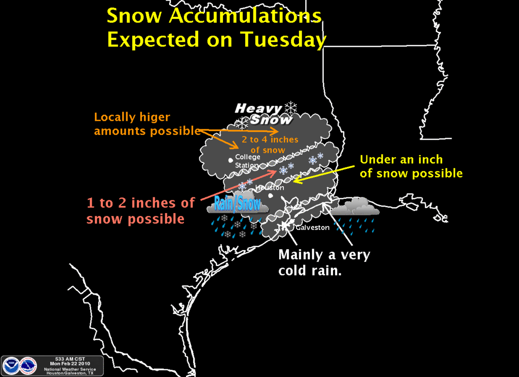
Here's the latest from Houston pro met Jeff Lindner:
Significant Winter Storm event heading for SE TX.
Accumulating snowfall expected Tuesday over portions of SE TX.
Winter Storm Watch issued for the following counties: Brazos, Burleson, Grimes, Washington, Montgomery, Walker, Houston, Madison, Trinity, San Jacinto, and Polk.
Discussion:
Cold air advection in progress this morning behind the late Sunday cold front. Cold arctic dome over the central plains will filter southward today while the next upper level storm noted over NV this morning makes the eastward turn and begins it treck toward TX. Stratus deck this morning may break up some this afternoon, before high clouds begin to arrive from the west. Clouds will thicken and lower tonight as moisture and lift increase.
Tuesday:
Strong upper level storm drops toward the Big Bend area with a developing shield of winter precip. Over much of central TX by morning. Forecast soundings show the air mass over the area dry and cold by Tuesday morning. A dry layer in the 900-800mb level will support some room for evaporative cooling of the air column with the onset of rain/snow Tuesday morning over our NW counties first and then spreading SE during the afternoon hours. Meso scale models continue to point toward a fairly unstable layer in the snow growth area around 700mb over the northern portions of SE TX Tuesday afternoon. Past events and studies with such instability (Dallas 2 week ago, and Victoria in Dec 2004) suggest the formation of meso scale banding and potential for very heavy snowfall rates. 700mb front will also be introduced into the mix to add forcing over our northern counties. May see a band of very heavy snow develop from College Station to Huntsville Tuesday afternoon/evening with significant accumulations.
Tuesday night:
Rain/snow mix will spread toward the coast with a change over to all snow across inland SE TX. At this time it appears the rain will mix with snow by mid afternoon toward Harris County and then change to snow after dark Tuesday as far south as US 59. Surface temperatures will fall toward freezing during the early evening hours as far south as I-10 as accumulating snow pack just to the north advects colder surface air southward. The southward extent of accumulation will likely end up over Austin/Waller/Harris/Liberty counties.
Accumulations:
College Station to Trinity northward:
Models are really pegging this area for some significant accumulations. For now will go all snow Tuesday/Tuesday night with accumulations of 2-4 inches and isolated locations of 6+” possible.
Austin to Brenham to Conroe to Coldspring northward:
Rain/snow mix will begin Tuesday morning and change to all snow Tuesday afternoon. Accumulations of 2-3” is likely with isolated totals of 3-5” possible.
Columbus to Downtown Houston to Liberty northward:
Rain will start the event changing to a rain/snow mix during the mid afternoon and all snow after dark. Accumulations of generally less than 1 inch is likely.
Columbus to Downtown Houston to Liberty southward:
Rain will start the event changing to rain/snow after dark Tuesday and possibly all snow before ending late Tuesday. Most of what falls in this region will melt on contact as surface temperatures struggle to get to freezing.
Impacts:
Surface temperatures are forecast to be in the 32-35 degree range for much of the day Tuesday as the snow falls which indicates a lot will melt on impact, except where heavy snow bands develop. Temperatures will drop Tuesday evening to or below freezing along and N of I-10 where melted snow on bridges and overpasses may begin to freeze. Additionally as surface temperatures fall toward/below freezing Tuesday evening snowfall will begin to accumulate faster mainly on elevated and grassy surfaces. Could see some icing/glazing of bridges and overpasses Tuesday evening into Wednesday morning over the northern ½ of the area.
While confidence is growing in this event, the amount of accumulation and where the rain/snow line ends up remains in some question. Forecasting meso banding location is extremely difficult, but very high impact and much of this will not be known until the event is underway.
Something to watch today is the dew point at IAH. It's currently 43F and it's forecast to stay at 40F or higher until during the day tomorrow. I think the GFS is incorrect there. It'll probably drop into the upper 30s in a few hours and be in the 36-37F range at the start of precip tomorrow. That still makes it marginal for accumulating snow.
Below is the predicted accumulation map from the 12Z (6am CST) NAM run. It's a lot drier than the GFS and a lot warmer for our area. Note that it did poorly with the last event (too warm):
wxman57 wrote:Something to watch today is the dew point at IAH. It's currently 43F and it's forecast to stay at 40F or higher until during the day tomorrow. I think the GFS is incorrect there. It'll probably drop into the upper 30s in a few hours and be in the 36-37F range at the start of precip tomorrow. That still makes it marginal for accumulating snow.
Where can we watch the dewpoints at? Is there a link or is it by location?
wxman57 wrote:Below is the predicted accumulation map from the 12Z (6am CST) NAM run. It's a lot drier than the GFS and a lot warmer for our area. Note that it did poorly with the last event (too warm):
If that graph holds true, what I huge BUST for SE tx...........
wxman57 wrote:Below is the predicted accumulation map from the 12Z (6am CST) NAM run. It's a lot drier than the GFS and a lot warmer for our area. Note that it did poorly with the last event (too warm):
wxman57 wrote:Something to watch today is the dew point at IAH. It's currently 43F and it's forecast to stay at 40F or higher until during the day tomorrow. I think the GFS is incorrect there. It'll probably drop into the upper 30s in a few hours and be in the 36-37F range at the start of precip tomorrow. That still makes it marginal for accumulating snow.
Where can we watch the dewpoints at? Is there a link or is it by location?
Just click the 3-letter identifier of the map region you want to plot (AUS for us). The green numbers to the lower left of the plots are dew points, the red numbers are temps.
wxman57 wrote:Something to watch today is the dew point at IAH. It's currently 43F and it's forecast to stay at 40F or higher until during the day tomorrow. I think the GFS is incorrect there. It'll probably drop into the upper 30s in a few hours and be in the 36-37F range at the start of precip tomorrow. That still makes it marginal for accumulating snow.
Where can we watch the dewpoints at? Is there a link or is it by location?


