
PRELIMINARY LOCAL STORM REPORT
NATIONAL WEATHER SERVICE AUSTIN/SAN ANTONIO TX
207 PM CST TUE FEB 23 2010
..TIME... ...EVENT... ...CITY LOCATION... ...LAT.LON...
..DATE... ....MAG.... ..COUNTY LOCATION..ST.. ...SOURCE....
..REMARKS..
0201 PM SLEET 1 WSW PAIGE 30.21N 97.14W
02/23/2010 U0.0 INCH BASTROP TX EMERGENCY MNGR
THE OVERPASS ON HIGHWAY 21 AT 290 HAS BEEN REDUCED TO
ONE LANE EASTBOUND DUE TO ICING
February Weather Discussion. Wild Winter Storms?
-
srainhoutx

- Site Admin

- Posts: 19616
- Joined: Tue Feb 02, 2010 2:32 pm
- Location: Maggie Valley, NC
- Contact:
Carla/Alicia/Jerry(In The Eye)/Michelle/Charley/Ivan/Dennis/Katrina/Rita/Wilma/Humberto/Ike/Harvey
Member: National Weather Association
Facebook.com/Weather Infinity
Twitter @WeatherInfinity
Member: National Weather Association
Facebook.com/Weather Infinity
Twitter @WeatherInfinity
-
TexasMetBlake
- Pro Met

- Posts: 839
- Joined: Wed Feb 03, 2010 7:03 pm
- Location: Spring/Woodlands
- Contact:
The change over is taking place in The Woodlands. I see the snowflakes mixing in with the rain now.
-
BigNorthSide
- Posts: 39
- Joined: Thu Feb 04, 2010 11:49 pm
- Location: Coldspring, TX
- Contact:
Candy Cane wrote:The change over is taking place in The Woodlands. I see the snowflakes mixing in with the rain now.
My question is will the moisture really continue into tonight like it was first thought??
Yeah, and will there be any "wrap around" affect that we see alot of times with these systems??
-
wxman57

- Global Moderator

- Posts: 2621
- Joined: Thu Feb 04, 2010 5:34 am
- Location: Southwest Houston (Westbury)
- Contact:
Latest RUC indicates rain changing to snow there briefly between 10pm and midnight. So don't expect anything there for a while.snowman65 wrote:Still cloudy in Orange.........tick-tock....tick-tock.........
-
AggieBuckeye
- Posts: 36
- Joined: Mon Feb 22, 2010 1:44 pm
- Location: Cypress, TX
- Contact:
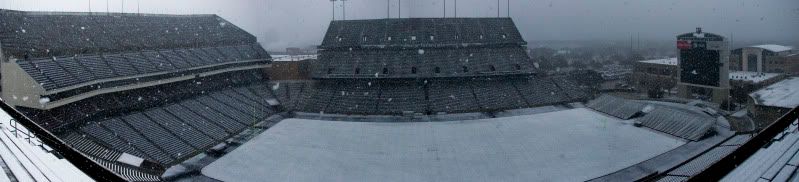
and the Kyle Field Webcam on A&M's campus
Beaumont temp 46 with DP at 35.......
-
BigNorthSide
- Posts: 39
- Joined: Thu Feb 04, 2010 11:49 pm
- Location: Coldspring, TX
- Contact:
Huge flakes mixed in with steady rain here 20 miles East of Lake Conroe on the Montgomery/San Jacinto county line 

sleet in Kingwood
buddy in the Woodlands reporting snow really beginning to fall
buddy in the Woodlands reporting snow really beginning to fall
Oh well, Maybe I will go to bed early.........how BORING..wxman57 wrote:Latest RUC indicates rain changing to snow there briefly between 10pm and midnight. So don't expect anything there for a while.snowman65 wrote:Still cloudy in Orange.........tick-tock....tick-tock.........
-
brazoria_county22
- Posts: 61
- Joined: Thu Feb 04, 2010 6:39 am
- Location: angleton,tx
- Contact:
what dose the latest RUC indicate for time frame for rain to switch over to snow if any for brazoria county
-
TexasMetBlake
- Pro Met
- Posts: 839
- Joined: Wed Feb 03, 2010 7:03 pm
- Location: Spring/Woodlands
- Contact:
Change over really happening now. Definitely see the snow in the air in The Woodlands!

Snow in New Waverly
-
srainhoutx
- Site Admin
- Posts: 19616
- Joined: Tue Feb 02, 2010 2:32 pm
- Location: Maggie Valley, NC
- Contact:
PRELIMINARY LOCAL STORM REPORT
NATIONAL WEATHER SERVICE HOUSTON/GALVESTON TX
249 PM CST TUE FEB 23 2010
..TIME... ...EVENT... ...CITY LOCATION... ...LAT.LON...
..DATE... ....MAG.... ..COUNTY LOCATION..ST.. ...SOURCE....
..REMARKS..
0126 PM SNOW MADISONVILLE 30.95N 95.91W
02/23/2010 E1.0 INCH MADISON TX BROADCAST MEDIA
0240 PM SNOW COLLEGE STATION 30.60N 96.31W
02/23/2010 E1.5 INCH BRAZOS TX TRAINED SPOTTER
QUARTER SIZED SNOW FLAKES SNOW UP TO 1.5 ACCUMULATING ON
GRASSY AREAS
Carla/Alicia/Jerry(In The Eye)/Michelle/Charley/Ivan/Dennis/Katrina/Rita/Wilma/Humberto/Ike/Harvey
Member: National Weather Association
Facebook.com/Weather Infinity
Twitter @WeatherInfinity
Member: National Weather Association
Facebook.com/Weather Infinity
Twitter @WeatherInfinity
-
txsnowmaker
- Posts: 632
- Joined: Wed Feb 03, 2010 4:07 pm
- Location: SW Houston (Galleria area)
- Contact:
Steady rain began a few minutes ago over by the Galleria.
-
TexasMetBlake
- Pro Met
- Posts: 839
- Joined: Wed Feb 03, 2010 7:03 pm
- Location: Spring/Woodlands
- Contact:
I've experienced the same. It mixes and then it doesn't. Right now, the snow has quit.nuby3 wrote:NW woodlands here.. had a few slushy plops earlier but moderate rain sinceMr. T wrote:sleet in Kingwood
buddy in the Woodlands reporting snow really beginning to fall

-
HouTXmetro
- Posts: 78
- Joined: Thu Feb 11, 2010 10:39 pm
- Location: Houston, TX (Medical Center/Reliant Park)
- Contact:
Snow Line really struggling to reach I-10, I'm afaid the moisture might be ending before Houton Proper can transistion into snow 