

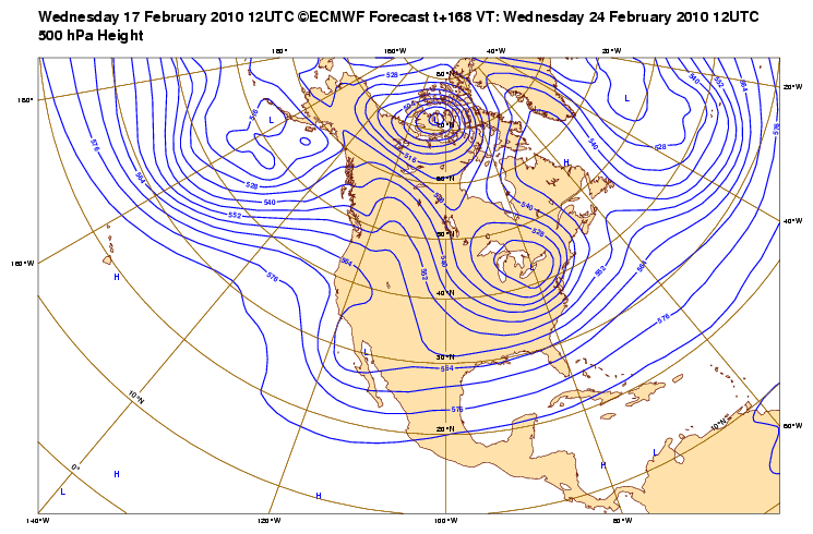
Depending on how much cold air is in placed, si' señor! However if the upper low passed directly overhead, then all bets may be off.txsnowmaker wrote:wxdata wrote:If the forecast holds, this would be interesting!
Thanks wxdata. Someone in another forum commented on this image, saying that it indicates the possibility of wintry precip developing NORTH of the low along the Texas coast, which would leave our area out of the fun. In your opinion, is that an accurate interpretation of this graphic?
February Weather Discussion. Wild Winter Storms?
-
txsnowmaker
- Posts: 632
- Joined: Wed Feb 03, 2010 4:07 pm
- Location: SW Houston (Galleria area)
- Contact:
wxdata wrote:Depending on how much cold air is in placed, si' señor! However if the upper low passed directly overhead, then all bets may be off.txsnowmaker wrote:wxdata wrote:If the forecast holds, this would be interesting!
Thanks wxdata. Someone in another forum commented on this image, saying that it indicates the possibility of wintry precip developing NORTH of the low along the Texas coast, which would leave our area out of the fun. In your opinion, is that an accurate interpretation of this graphic?
Thanks! Hopefully this is the start of a trend that will continue to include a chance for winter weather in Houston sometime next week.

0z GFS shows a pretty decent front at 162hr retreats rather quickly though.

0z Euro looks interesting for sure next week...
-
Portastorm

- Posts: 800
- Joined: Wed Feb 03, 2010 3:04 pm
- Location: Southwest Austin/Oak Hill, TX
- Contact:
Absolutely! If that run verifies ... it is GAME ON for a nice winter weather event (finally!) in my part of the state.don wrote:0z Euro looks interesting for sure next week...
http://www.meteo.psu.edu/~gadomski/ECMW ... floop.html
-
srainhoutx

- Site Admin

- Posts: 19616
- Joined: Tue Feb 02, 2010 2:32 pm
- Location: Maggie Valley, NC
- Contact:
HGX morning AFD took note of the changes overnight and now things look rather interesting if it verifies...
AREA FORECAST DISCUSSION
NATIONAL WEATHER SERVICE HOUSTON/GALVESTON TX
410 AM CST WED FEB 17 2010
.DISCUSSION...
SFC ANALYSIS SHOWS WEAK HIGH PRESSURE OVER MUCH OF TX WITH
ESSENTIALLY CALM WINDS OR PERHAPS A LIGHT NORTH WIND. OUTSIDE THE
HOUSTON METRO AREA AND THE GULF COAST...TEMPS CONTINUE TO DROP
INTO THE LOW 30S/UPPER 20S. HOUSTON AREA REMAINS IN THE UPPER 30S
BUT SHOULD SEE TEMPS DROP A FEW MORE DEGREES UNDER CLEAR SKIES
AND CALM WINDS. AS WAS THE CASE YESTERDAY...SHOULD SEE A NICE
WARM UP TODAY PERHAPS INTO THE LOW 60S AND THEN MID 60S FOR THE
NEXT COUPLE OF DAYS. SFC RIDGE OVER TX WILL SHIFT EAST ALONG THE
N GULF COAST AND THIS WILL ALLOW FOR SFC WINDS TO TURN AROUND TO
THE SE. GULF MOISTURE WILL SLOWLY MOVE BACK INTO SE TX FOR THE
END OF THE WEEK.
THIS MORNINGS WATER VAPOR IMAGERY SHOWS A BROAD UPPER LEVEL
TROUGH OFF THE COAST OF BAJA MEXICO IN THE PACIFIC. THIS SYSTEM
WILL SLOWLY SHEAR OUT AND PULL ACROSS MEXICO INTO S TX BY FRI
MORNING. THERE SHOULD BE ANOTHER NW GULF COASTAL LOW PRESSURE
SYSTEM TO DEVELOP BUT THIS SYSTEM SHOULD REMAIN WELL OUT IN THE
GULF. AS SUCH THE OFFSHORE WATERS WILL LIKELY SEE THE BULK OF ANY
PRECIP BUT WILL STILL KEEP 30/40 POPS FOR THE COASTAL COUNTIES.
THIS SYSTEM WILL MOVE OUT OF THE AREA FRI NIGHT WHICH SHOULD
LEAVE A DRY FORECAST FOR SATURDAY. STILL HESITATE TO REMOVE POPS
AS GULF MOISTURE WILL CONTINUE TO INCREASE OVER THE AREA AS THERE
WILL NOT BE ANY REAL CHANGE IN AIRMASS. PLUS THE GFS/ECMWF
SOLUTIONS BRING A COLD FRONT INTO N TX SO SHOULD SEE A DECENT
MOISTURE AXIS DEVELOP AHEAD OF IT.
THE 00Z GFS/ECMWF ARE MORE CONSISTENT NOW WITH BRINGING THE COLD
FRONT THROUGH SE TX LATE SUN NIGHT INTO MON MORNING. POPS WERE
BUMPED UP TO 40 PERCENT FOR SUN AFTERNOON AND NIGHT AS THE WARM
SECTOR BECOMES UNSTABLE WITH CAPE AROUND 1500-2000 J/KG. IT IS A
LITTLE EARLY TO ASSESS ANY SEVERE POTENTIAL BUT GIVEN THE
INSTABILITY AND MORE THAN ENOUGH DEEP LAYER SHEAR...ORGANIZED
CONVECTION WILL BE POSSIBLE SO SEVERE THUNDERSTORM ACTIVITY
CANNOT BE RULED OUT. MONDAY SHOULD BE MUCH COLDER AGAIN AS A MORE
CANADIAN TYPE AIRMASS MOVES DOWN THE PLAINS INTO SE TX.
MON THROUGH WED...AT THIS POINT MODEL SOLUTIONS DIVERGE IN THE
UPPER LEVELS WHERE THE ECMWF HOLDS BACK A TROUGH OVER THE DESERT
SW WHILE THE GFS IS MORE PROGRESSIVE. A LOT OF THIS DEPENDS ON
HOW THE MODELS HANDLE THE OMEGA BLOCK/SPLIT FLOW PATTERN AND HOW
ANY SHORTWAVES PASS UNDER THE RIDGE OVER THE PAC NW. THIS MAKES
THE EXTENDED FORECAST RATHER TRICKY SO FOR NOW WILL COVER TUE/WED
WITH 20 POPS. THE REAL FORECAST CHALLENGE WILL ALSO BE PRECIP
TYPE. BOTH THE ECMWF AND GFS KEEP A FAIRLY COLD AIRMASS OVER TX
DURING THIS TIME. THE GFS BRINGS A POTENT SHORTWAVE TROUGH ACROSS
SE TX AROUND 12Z TUE WITH MODEL SOUNDINGS INDICATING A TRANSITION
OF RAIN TO SLEET TO SNOW. GIVEN THE UNCERTAINTY IN THE UPPER
LEVEL PATTERN...FORECAST WILL KEEP WITH RAIN BUT SHOULD THE GFS
DEVELOPS SOME RUN TO RUN CONSISTENCY...THE FORECAST WILL NEED TO
BE UPDATED FOR THE POSSIBILITY OF A 6-12 HR PERIOD OF FROZEN
PRECIP DURING TUE MORNING. WITH THAT SAID...PRECIP STILL COULD BE
SHIFTED TO WED IN LINE WITH THE ECMWF. STILL AGAIN WITH A STRONG
SHORTWAVE MOVING ACROSS THE AREA AND THE COLD AIRMASS...COULD SEE
FROZEN PRECIP BEING A POSSIBILITY STILL. THE MAIN POINT OF ALL OF
THIS IS THAT THE MODELS WILL BE CLOSELY MONITORED FOR THE
POSSIBILITY OF A WINTER PRECIP EVENT FOR SE TX NEXT TUE/WED.
39
Also worth posting the night shift HPC Prelim Extended Disco. The day shift should Update shortly...
PRELIMINARY EXTENDED FORECAST DISCUSSION
NWS HYDROMETEOROLOGICAL PREDICTION CENTER CAMP SPRINGS MD
400 AM EST WED FEB 17 2010
VALID 12Z SUN FEB 21 2010 - 12Z WED FEB 24 2010
USED THE 00Z/17 ECMWF FOR THE PRELIMINARY FRONTS AND PRESSURES FOR
DAYS 3-5...WITH AN EVEN BLEND OF THE 00Z/17 ECMWF AND 12Z/16 ECENS
MEAN DAYS 6 AND 7. THE 00Z/17 ECMWF...GEFS MEAN...AND 12Z/16
ECENS MEAN CLUSTER WELL WITH MOST OF THE MAJOR SYNOPTIC FEATURES
THROUGH THE MIDDLE OF THE PERIOD...FAR AND AWAY BETTER THAN THE
DISPARATE SOLUTIONS OF THE 00Z/17 DETERMINISTIC GFS...GEM
GLOBAL...AND TO A LESSER EXTENT THE UKMET. THE UKMET SUPPORTS THE
ECMWF WITH BOTH THE CHUNK OF POLAR AIR PULLED INTO THE SOUTHWEST
DAY 5...AS WELL AS THE MORE SUPPRESSED TRACK OF THE MAJOR WAVE
CROSSING THE EAST LATE DAY 5 INTO DAY 6. BLENDED THE ECMWF WITH
ITS MOST RECENT MEAN THE LAST TWO DAYS TO MITIGATE THE LATITUDE AT
WHICH THE CYCLONE PASSES OFF THE ATLANTIC COAST DAY 6...AS WELL AS
EVEN OUT THE LATITUDE OF THE NEXT WAVE OF PACIFIC ENERGY
APPROACHING NORTH AMERICA DAY 7. THE GFS AND GEM GLOBAL LOOK
SUSPECT WITH THE RUSH OF LOW PRESSURE UP THE OHIO VALLEY MID
PERIOD...CONSIDERING THE BLOCKY FLOW REGIME WHICH HAS HELD MOST OF
THE WINTER. THE SYSTEM CROSSING THE EAST LATE DAY 5 INTO DAY 6
HAS THE POTENTIAL TO HIGHLY IMPACT SOME OF THE AREAS ALREADY HIT
BY MAJOR SNOWSTORMS THIS SEASON.
CISCO
Carla/Alicia/Jerry(In The Eye)/Michelle/Charley/Ivan/Dennis/Katrina/Rita/Wilma/Humberto/Ike/Harvey
Member: National Weather Association
Facebook.com/Weather Infinity
Twitter @WeatherInfinity
Member: National Weather Association
Facebook.com/Weather Infinity
Twitter @WeatherInfinity
-
wxman57

- Global Moderator

- Posts: 2621
- Joined: Thu Feb 04, 2010 5:34 am
- Location: Southwest Houston (Westbury)
- Contact:
The amount of moisture that the GFS is forecasting for next Tuesday is about 0.05", just above a trace. So it's not forecasting any event similar to Dallas a week ago. Just a trace of sleet with temps in the mid to upper 30s. Way too much run-to-run variance to believe the 00Z run. 00Z Euro is a bit colder and wetter with next week's system, so it could be the GFS is off in the "right' way for us to get a shot at some frozen precip.

-
txsnowmaker
- Posts: 632
- Joined: Wed Feb 03, 2010 4:07 pm
- Location: SW Houston (Galleria area)
- Contact:
I am reminded of srain's statement that the EC has been first in "verification" this winter. So if history is any guide, hopefully at this point in time we can take the GFS forecast models for next week for what they are worth (not much) and place our confidence in the colder and wetter Euro. Euro still trending towards a "happy" solution for us. May that continue...
-
wxman57
- Global Moderator
- Posts: 2621
- Joined: Thu Feb 04, 2010 5:34 am
- Location: Southwest Houston (Westbury)
- Contact:
Yes, the EC has been "first" if you're only comparing northern hemisphere 500 mb height forecasts, with the GFS not very far behind. But that doesn't mean the EC was better for specific areas, like SE TX. However, it does appear as though the GFS is lost as far as the pattern beyond 3-4 days, so I'd follow the EC closer for next week's weather.txsnowmaker wrote:I am reminded of srain's statement that the EC has been first in "verification" this winter. So if history is any guide, hopefully at this point in time we can take the GFS forecast models for next week for what they are worth (not much) and place our confidence in the colder and wetter Euro. Euro still trending towards a "happy" solution for us. May that continue...
-
txsnowmaker
- Posts: 632
- Joined: Wed Feb 03, 2010 4:07 pm
- Location: SW Houston (Galleria area)
- Contact:
wxman57 wrote:Yes, the EC has been "first" if you're only comparing northern hemisphere 500 mb height forecasts, with the GFS not very far behind. But that doesn't mean the EC was better for specific areas, like SE TX. However, it does appear as though the GFS is lost as far as the pattern beyond 3-4 days, so I'd follow the EC closer for next week's weather.txsnowmaker wrote:I am reminded of srain's statement that the EC has been first in "verification" this winter. So if history is any guide, hopefully at this point in time we can take the GFS forecast models for next week for what they are worth (not much) and place our confidence in the colder and wetter Euro. Euro still trending towards a "happy" solution for us. May that continue...
Thanks for the explanation, wxman57. Also, glad to see your expert opinion suggests following the EC closer for next week.
-
wxman57
- Global Moderator
- Posts: 2621
- Joined: Thu Feb 04, 2010 5:34 am
- Location: Southwest Houston (Westbury)
- Contact:
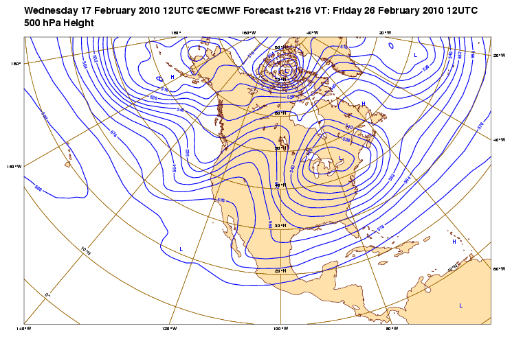
Well, the 12Z GFS still appears lost next week. I think it looks OK for the next 3-4 days, though. Not too bad of a weekend coming up. Notice I've raised the temperature scale from 0-75F to 10-85F. Wishful thinking, maybe, but I can't wait for this winter to end!

Looks like quite a difference in the Feb 24 cold air temps as well........wow. Is the winter weather a washout?
-
redneckweather
- Posts: 1023
- Joined: Mon Feb 08, 2010 7:29 pm
- Location: Montgomery, Texas
- Contact:
What's JB's (not word for word) take on Texas next week?
-
srainhoutx
- Site Admin
- Posts: 19616
- Joined: Tue Feb 02, 2010 2:32 pm
- Location: Maggie Valley, NC
- Contact:
HPC thoughts in the Final Extended Disco...talk about a new wrinkle... 
EXTENDED FORECAST DISCUSSION
NWS HYDROMETEOROLOGICAL PREDICTION CENTER CAMP SPRINGS MD
230 PM EST WED FEB 17 2010
VALID 12Z SAT FEB 20 2010 - 12Z WED FEB 24 2010
OVER THE NEXT WEEK...A STRONG NEGATIVE NAO WILL CONTINUE AT HIGH
LATITUDES...WHILE AN ACTIVE
SRN STREAM ASSOCIATED WITH EL NINO WILL PERSIST AT LOW LATITUDES.
IN BETWEEN IS WHERE THE RUBBER MEETS THE ROAD. IN THE MIDDLE
LATITUDES...COMPLEX INTERACTIONS ARE EXPECTED BETWEEN THE
SUBTROPICAL JET AND POLAR/ARCTIC SYS THAT HAVE BEEN DETOURED S OF
THEIR NORMAL TRACK BY THE PERSISTENT STRONG NEGATIVE NAO. ENSEMBLE
SPAGHETTI PLOTS SHOW THAT THE GREATEST CHALLENGE OF THE DAY WILL
BE HANDLING THE DETAILS OF SRN STREAM SHORTWAVES UNDERCUTTING THE
STRONG MID AND HIGHER LATITUDE RIDGE OVER THE W COAST OF NOAM.
THESE COMPLEX INTERACTIONS HAVE PROVEN TO BE A CHALLENGE FOR THE
DETERMINISTIC MODELS...
ESPECIALLY THE GFS. CONTINUITY BREAKS DOWN IN THE NEW 12Z/17 GFS
RUN FROM ITS 00Z RUN AS EARLY AS SUN DAY 4...WHERE NRN STREAM
ENERGY GETS TUCKED SW UNDER THE SE SIDE OF A BLOCKING HIGH OVER
THE ALASKAN PANHANDLE RATHER THAN DROPPING MORE S INTO THE GREAT
BASIN AS PER 00Z/17 GFS CONTINUITY. THIS RESULTS IN A SUBSEQUENT
DIFFERENT HANDLING OF TWO SRN STREAM SHORTWAVES ...PUTTING THEM
OUT OF PHASE WITH 00Z GFS CONTINUITY BY SUN EVE.
WE WOULD HAVE IGNORED THE NEW 12Z GFS WITH THE WAY IT BROUGHT A
SIGNIFICANT SHORTWAVE ALL THE WAY TOWARDS THE MID MS VLY BY SUN
EVE/EARLY MON...WERE IT NOT FOR THE FACT THAT ALMOST ALL THE
REMAINDER OF 12Z/17 GUIDANCE CLUSTERS FAIRLY WELL ON A 500MB TROF
NEAR OR JUST E OF 90W BY MON MORNING DAY 5. THIS CONSENSUS CLUSTER
LED US TO ACCEPT THE TREND THAT THE 00Z/17 CANADIAN HAD SHOWN IN
MOVING A LOW UP THE OH VLY. IN FACT THE NEW ECMWF ALSO JOINED THE
MAJORITY CLUSTER MOVING A LOW UP THE OH VLY ON DAY 5... WHICH WAS
SIMILAR TO ITS DAY 6 RUN FROM 12Z YESTERDAY.
AWAY FROM OUR ADJUSTMENT OF THE NEW OH VLY/MID ATLANTIC STORM
EARLY NEXT WEEK...FINAL PROGS STAYED WITH THE SAME BLEND THAT WAS
USED IN THE UPDATED PRELIM....A ECMWF GEFS MEAN/ECMWF MEAN DAY 3-5
THAT TAPERED TO ALL GEFS MEAN AND ECMWF MEAN BY WED DAY 7.
CONCERNING THE NEXT POSSIBLE SIGNIFICANT STORM TO AFFECT THE MID
ATLANTIC REGION MON/TUE...
THE HIGHEST POTENTIAL FOR A MAJOR SNOWSTORM APPEARS TO BE N OF
WHERE THE HEAVIEST SNOWS HAVE ALREADY FALLEN THIS YEAR....ACROSS
THE SRN GRT LAKES INTO SRN NEW ENG. THE MID ATLANTIC AREA MAY SEE
MIXED PRECIP AT THE BEGINNING OF THE EVENT BUT CHANGE TO RA FAIRLY
QUICKLY FROM S TO N. THE BEST THREAT OF HVY SNOWFALL APPEARS TO BE
FROM N OF NEW YORK CITY TO BOS AT THIS TIME. SOME LOCALLY HEAVY
RAIN MAY OCCUR ALONG THE TRAILING COLD FRONT OF THIS SYS THRU THE
GULF STATES.
SRN NSTREAM ACTIVITY WILL ALSO BRING GEENROUS PRPECIP TO CA WITH
LESSER BUT STILL SIGNIFICANT AMOUNTS INTO THE SRN ROCKIES.
FLOOD
Carla/Alicia/Jerry(In The Eye)/Michelle/Charley/Ivan/Dennis/Katrina/Rita/Wilma/Humberto/Ike/Harvey
Member: National Weather Association
Facebook.com/Weather Infinity
Twitter @WeatherInfinity
Member: National Weather Association
Facebook.com/Weather Infinity
Twitter @WeatherInfinity
-
srainhoutx
- Site Admin
- Posts: 19616
- Joined: Tue Feb 02, 2010 2:32 pm
- Location: Maggie Valley, NC
- Contact:
Pacific RECON will continue...
000
NOUS42 KNHC 171800
WEATHER RECONNAISSANCE FLIGHTS
CARCAH, NATIONAL HURRICANE CENTER, MIAMI, FL.
0100 PM EST WED 17 FEBRUARY 2010
SUBJECT: WINTER STORM PLAN OF THE DAY (WSPOD)
VALID 18/1100Z TO 19/1100Z FEBRUARY 2010
WSPOD NUMBER.....09-079
I. ATLANTIC REQUIREMENTS
1. NEGATIVE RECONNAISSANCE REQUIREMENTS.
2. SUCCEEDING DAY OUTLOOK.....NEGATIVE
II. PACIFIC REQUIREMENTS
1. FLIGHT ONE - TEAL 70
A. P28/ 35.0N 150.8W/ 19/1200Z
B. AFXXX 33WSC TRACK28
C. 19/0600Z
D. 20 DROPS ON TRACK
E. AS HIGH AS POSSIBLE/ 19/1800Z
FLIGHT TWO - NOAA49
A. P99/ 40.0N 172.0E /19/1200Z
B. NOAA9 34WSW TRACK99
C. 19/0800Z
D. REQUEST 20 DROPS EAST OF 150E
E. 41,000 TO 45,000 FT/ 19/1800Z
F. TRACK: 36.3N 140.6E, 44.8N 166.6E, 43.9N 169.8E,
40.0N 172.8E, 34.1N 170.7E, 36.3N 155.4E,
36.4N 139.7E.
2. SUCCEEDING DAY OUTLOOK: PSBL GIV GLIGHT/
TRACK TBD/ 19/1200Z
3. NOTE: THE TRACK FOR MISSION 31WSC WAS CHANGED BY THE
SDM FROM TRACK 29 TO TRACK 21 FOR 18/1200Z. WVW
Carla/Alicia/Jerry(In The Eye)/Michelle/Charley/Ivan/Dennis/Katrina/Rita/Wilma/Humberto/Ike/Harvey
Member: National Weather Association
Facebook.com/Weather Infinity
Twitter @WeatherInfinity
Member: National Weather Association
Facebook.com/Weather Infinity
Twitter @WeatherInfinity
-
redneckweather
- Posts: 1023
- Joined: Mon Feb 08, 2010 7:29 pm
- Location: Montgomery, Texas
- Contact:
Ok srain, where is the wrinkle? 
-
srainhoutx
- Site Admin
- Posts: 19616
- Joined: Tue Feb 02, 2010 2:32 pm
- Location: Maggie Valley, NC
- Contact:
Well, the Mid Atlantic was preparing for a Major Winter Storm this morning, now all guidance takes that storm much further W instead of affecting the East Coast. They were looking for a snow event and now it is a rain/flooding event. Also, the guidance is suggesting an interesting Upper Air disturbance with some mighty chilly air around the 24th +/- a couple of days for TX. It was a major wrinkle in what the HPC was expecting and may very well be a 'hint' of things to come. Also there is a very deep trough showing up now for the eastern 2/3rd of the CONUS for this time of year and bears watching IMHO.
Carla/Alicia/Jerry(In The Eye)/Michelle/Charley/Ivan/Dennis/Katrina/Rita/Wilma/Humberto/Ike/Harvey
Member: National Weather Association
Facebook.com/Weather Infinity
Twitter @WeatherInfinity
Member: National Weather Association
Facebook.com/Weather Infinity
Twitter @WeatherInfinity
-
TexasMetBlake
- Pro Met

- Posts: 839
- Joined: Wed Feb 03, 2010 7:03 pm
- Location: Spring/Woodlands
- Contact:
Dallas Thoughts:
EYOND MONDAY...GLOBAL GUIDANCE DIVERGES MORE SIGNIFICANTLY. THE
FAVORED ECMWF PINCHES OFF A PIECE OF EASTERN PACIFIC
ENERGY...MERGES IT WITH THE TROF OVER THE WESTERN US AND CLOSES OFF
AN UPPER LOW. THIS IS SIGNIFICANT BECAUSE THERE IS SOME FAIRLY
COLD AIR ASSOCIATED WITH THIS FEATURE ALONG WITH SOME AVAILABLE
MOISTURE. THE EC MAY BE A LITTLE AGGRESSIVE WITH THE MOISTURE BUT
THE GENERAL IDEA IS SHARED BY SEVERAL OF THE GFS ENSEMBLE MEMBERS. THE
OPERATIONAL GFS HANDLES THE EAST PACIFIC ENERGY DIFFERENTLY AND
THEREFORE IS MORE PROGRESSIVE WITH THE WESTERN US TROF LEAVING N
TX DRY. FOR NOW...WILL KEEP SOME COLDER TEMPS IN PLACE BUT WILL
KEEP THE FORECAST DRY UNTIL WE CAN GET A BETTER HANDLE ON THE
UPPER PATTERN.
AND FINALLY...THERE IS SOME VERY COLD AIR ACROSS FAR NORTHERN
CANADA THAT WILL SLIDE SOUTH INTO NORTH CENTRAL CANADA BY THE
WEEKEND. DESPITE SIGNIFICANT MODEL DIFFERENCES...THERE IS A
GENERAL CONSENSUS TO DAMPEN THE WESTERN CANADA RIDGING BY THE
MIDDLE OF NEXT WEEK THEREBY MAKING IT LESS LIKELY THAT A CHUNK OF
THIS VERY COLD AIR WILL BE ABLE TO HEAD SOUTH INTO THE CENTRAL AND
SOUTHERN PLAINS...BUT WILL MONITOR THIS CLOSELY.

BRRRR! I can't take any more cold weather, I'm packin my bags.... I'll check in with yall when I get back from Tahiti.
Someone please pass this to Old Man Winter....."Either **** or get off the pot!!!". Tired of all this teasing....if you are done then LEAVE and lets move on to spring and summer.....
-
- Information
-
Who is online
Users browsing this forum: Ahrefs [Bot], Bing [Bot], don, TexasBreeze and 30 guests